Coastal Management Project - Responding to Climate Change - Coastal Management Options
←
→
Page content transcription
If your browser does not render page correctly, please read the page content below
Coastal Management Project –
Responding to Climate Change

   Coastal Management Options
                       for
 Tasman Bay/Te Tai o Aorere and Golden Bay/Mohua

                  September 2021
For further information on this report or our Coastal Management Project, please contact:

 Coastal Management Project
 Tasman District Council
 c/o 189 Queen Street
 Private Bag 4, Richmond, 7050

 Phone: 03 543 8400
 Email: tasmancoastalmanagement@tasman.govt.nz
 View: tasman.govt.nz/coastal-management

                                                 2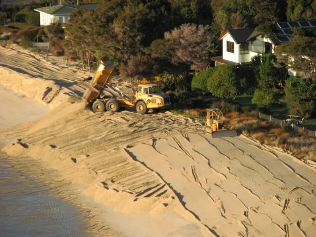
Executive Summary
In July 2019, Tasman District Council launched its ‘Coastal Management Project – Responding to
Climate Change’ initiative which aims to enable our Tasman Bay/Te Tai o Aorere and Golden
Bay/Mohua communities to work towards long-term adaptive planning for coastal hazards and sea
level rise. This project is guided by the recommended good practice set out in the Ministry for the
Environment’s 2017 Coastal Hazards and Climate Change Guidance.
This report sets out a range of high-level options for coastal management in our District to respond
to sea level rise and coastal hazards. Initially, it is important to look at each of the high-level options
at a regional level to understand the range of possible coastal management responses. The options
are grouped into four categories – accommodate, protect, avoid, and retreat. The options relate to
both new development and intensification within existing developed areas.
The range of options listed is not exhaustive and there may be alternative options not identified.
Through our community discussions during this phase of work, we are seeking your feedback to
understand your views on these options or if there are alternative options or ideas for coastal
management that we should consider. This will ensure that we avoid narrowing down the options
too early in the process.
This report does not provide specific recommendations for decision-making. Rather, it provides an
information base to assist in broadening our knowledge of coastal management options to facilitate
better informed decision-making in the future. Next steps in the Coastal Management Project will
consider specific options and recommendations at the local level.
Section 2 sets out the current legislative context for the management of natural hazards and
responding to sea level rise under the Resource Management Act 1991 (RMA 1991), including the
New Zealand Coastal Policy Statement 2010. This section also identifies two key central government-
led pieces of work that will significantly influence future phases of the Coastal Management Project.
These are the current resource management system reform including the development of a Climate
Adaptation Act; and the preparation of a National Adaptation Plan (due by August 2022).
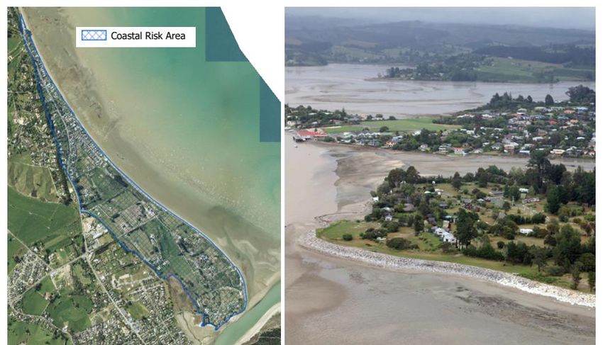
Section 3 identifies that many low-lying parts of our District’s coastline has already experienced
coastal storm inundation and/or coastal erosion. While there is much uncertainty around the rate
and magnitude of sea level rise, we do know that rising sea levels will have increasing implications
for development and infrastructure in coastal areas along with environmental, cultural and societal
effects.
Section 4 highlights that regardless of the uncertainty around the rate and magnitude of sea level
rise, we need to be proactive in our longer-term adaptive planning to ensure our communities are
resilient. The decisions we make today will affect our children, grandchildren and future
communities. This is because many land use planning, asset and infrastructure decisions lead to the
construction of buildings and infrastructure that have long lifetimes. To avoid the risk of ‘locking in’
decisions that cannot be changed if they are no longer fit for purpose, the use of planning tools such
as the dynamic adaptive policy pathways (DAPP) approach can be used to design an adaptive
strategy that is robust over different scenarios into the future.
Section 5 details the four groupings of high-level options, namely:
• Accommodate: These options enable continued use of coastal land but existing development is
adjusted, or new development is designed, to anticipate the hazard risk. Examples include
3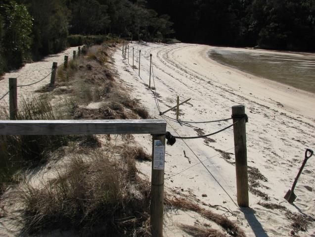
raising ground and/or floor levels of buildings, requiring relocatable houses, or providing
    alternative inundation pathways.
•   Protect: These options ‘hold the line’ and include soft options (e.g. dune and beach
    nourishment, wetland restoration/enhancement) and hard options (e.g. sea walls, groynes,
    stopbanks, tide banks, causeways) to protect coastal areas from the sea.
•   Avoid: This option uses land-use planning measures to avoid further intensification of existing
    built areas or the development of new sites in low lying coastal locations. Examples include
    policies and rules within resource management plans to control the types and densities of land
    uses (via zoning), subdivision and building restrictions, and coastal setbacks.
•   Retreat: This option applies to existing development and involves moving people, assets and
    activities away from the coast. It can take place across a range of scales from individual
    properties (e.g. moving a building further back on a property), to relocating whole communities
    and infrastructure, or enabling ecological migration of coastal species and habitats.

Section 5 also includes case studies that illustrate the range of measures (options) implemented
within our District; and details potential barriers and risks associated with the implementation of the
range of options.

Section 6 recognises there are a number of factors that will motivate and influence the perspectives
of individuals within the decision-making process around the suitability of options. Factors include
differences in risk perception and acceptability of risk; differing values and competing interests;
property values; property insurance; and who pays. Coastal management is a complex, challenging
and emotive topic that impacts on the places we live, work, play and value.

As we work towards long-term adaptive planning for sea level rise and coastal hazards, input will be
required from a range of community interests. Next steps in the Coastal Management Project will
consider options at the local level in discussion with landowners and residents, iwi and our
communities. The outputs of the central government-led work regarding the RMA 1991 system
reform and National Adaptation Plan will inform this work.

                                                   4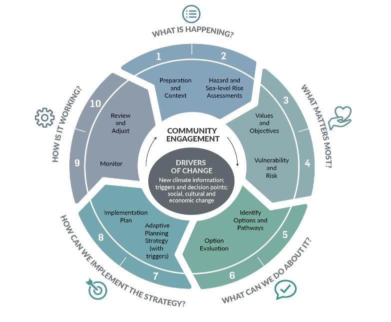
Contents
Executive Summary ................................................................................................................................ 3
1.     Introduction .................................................................................................................................... 7
     1.1      Purpose ................................................................................................................................... 7
     1.2      Background ............................................................................................................................. 7
     1.3      Key Terms ................................................................................................................................ 9
2.     Legislative Framework.................................................................................................................... 9
     2.1      Existing Legislative Framework .............................................................................................. 9
     2.1.1 Resource Management Act 1991 ............................................................................................ 9
     2.1.2 Climate Change Response Act 2002 ........................................................................................ 9
     2.2      Resource Management System Reform............................................................................... 10
3.     Natural Hazards and Sea Level Rise ............................................................................................. 10
     3.1      Vulnerability to Coastal Storm Inundation .......................................................................... 10
     3.2      Vulnerability to Coastal Erosion ........................................................................................... 11
     3.3      The Uncertainty of Sea Level Rise ........................................................................................ 11
     3.4      Other Natural Hazards in the Coastal Area .......................................................................... 12
4.     Planning for the Uncertainty of Sea Level Rise ........................................................................... 12
     4.1      Planning for Uncertainty ...................................................................................................... 12
     4.2      Dynamic Adaptive Policy Pathways (DAPP) ......................................................................... 13
     4.2.1 What is DAPP? ....................................................................................................................... 13
     4.2.2 Using DAPP in Tasman ........................................................................................................... 14
5      Coastal Management Options ..................................................................................................... 15
     5.1      Introduction .......................................................................................................................... 15
     5.2      Accommodate ....................................................................................................................... 16
     5.3      Protect ................................................................................................................................... 18
     5.3.1 Soft protection....................................................................................................................... 19
     5.3.2 Hard Protection ..................................................................................................................... 20
     5.4      Avoid ..................................................................................................................................... 22
     5.5      Retreat................................................................................................................................... 24
     5.6      We Want Your Feedback on These Options ........................................................................ 26
6.     Factors That Influence Our Perspectives in the Decision-Making Process ................................. 28
     6.1      Introduction .......................................................................................................................... 28
     6.2      Differences in Risk Perception.............................................................................................. 28
     6.3      Differing Values and Competing Interests ........................................................................... 29
     6.4      Property Values..................................................................................................................... 29
     6.5      Property Insurance ............................................................................................................... 29

                                                                            5
6.6         Social Vulnerability and Inequalities .................................................................................... 30
     6.7         Who Pays? ............................................................................................................................. 31
7.        Next Steps ..................................................................................................................................... 31
8.        References .................................................................................................................................... 33
APPENDIX A: Key Terms ....................................................................................................................... 35
     1.          Natural Hazards .................................................................................................................... 35
     2.          Risk ........................................................................................................................................ 35
     3.          Climate Change Mitigation ................................................................................................... 36
     4.          Adaptation ............................................................................................................................ 36
     5.          Resilience .............................................................................................................................. 36
APPENDIX B: Legislative Framework ................................................................................................... 37
     1.1         Existing Legislative Framework ............................................................................................ 37
     1.1.1 Resource Management Act 1991 .......................................................................................... 37
     1.1.2 Climate Change Response Act 2002 ...................................................................................... 38
     1.1.3 Other Legislation ................................................................................................................... 38
     1.2         Resource Management System Reform............................................................................... 38
Appendix C: New Zealand Coastal Policy Statement 2010 ................................................................. 40
Appendix D: Tasman District Council’s Coastal Protection Policy ...................................................... 42

                                                                                6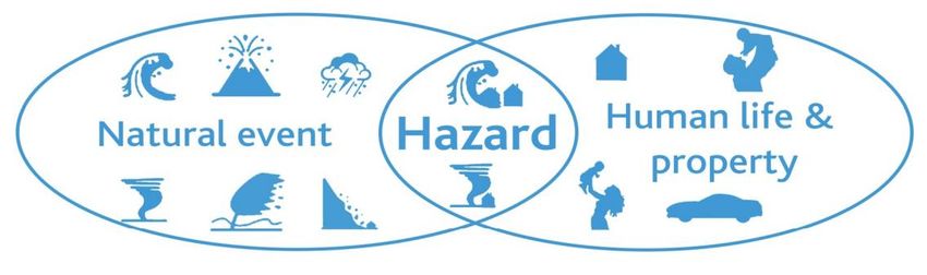
1.    Introduction
1.1 Purpose
In July 2019, Tasman District Council (the Council) launched its ‘Coastal Management Project –
Responding to Climate Change’ initiative which aims to enable our Tasman Bay/Te Tai o Aorere and
Golden Bay/Mohua communities to work towards long-term adaptive planning for coastal hazards
and sea level rise.

This report sets out a range of high-level options for coastal management in our district to respond
to sea level rise and coastal hazards (coastal storm inundation and coastal erosion). Initially, it is
important to look at each of the high-level options at a regional level to understand the range of
possible coastal management responses. This will ensure that we avoid narrowing down the options
too early in the process. Future steps in the Coastal Management Project will consider specific
options and recommendations at the local level, in discussion with landowners and residents, iwi
and our communities.

This report does not provide specific recommendations for decision-making. Rather, it provides an
information base to assist in broadening our knowledge of coastal management options to facilitate
better informed decision-making in the future.

The options are grouped into four categories – accommodate, protect, avoid, and retreat. The
options presented relate to both new development and intensification within existing developed
areas. Potential barriers and risks associated with the implementation of these options are identified
and discussed. A number of case studies are included that illustrate the range of coastal
management measures which are already implemented within our District.

The report is structured as follows:

•    Section 2 – sets out the legislative framework for coastal hazards management
•    Section 3 – summarises what we know about our coastal hazards and rising sea levels
•    Section 4 – discusses the challenges we face of planning for the uncertainty of sea level rise
•    Section 5 – identifies a range of options for coastal management and encourages feedback on
     these options via the Council’s website and feedback forms
•    Section 6 – identifies a number of factors that influence our perspectives in decision-making
•    Section 7 – sets out next steps

The outputs from the Coastal Management Project will be used to inform a number of Council’s core
functions including the development of the new Aorere ki uta, Aorere ki tai - Tasman Environment
Plan (resource management plan), resource and building consent processes, activity management
plans, reserves management plans, and civil defence and emergency management.

1.2 Background
The impacts of climate change affect us all, and in Tasman we continue to experience the effects of
significant weather and storm events. As a Council, we are looking to better prepare our
communities for the effects of ongoing changes to weather patterns and rising sea levels. This
conversation is occurring in coastal communities all around New Zealand.

The Coastal Management Project uses as a guide the recommended good practice set out in the
Ministry for the Environment’s 2017 Coastal Hazards and Climate Change Guidance (MfE 2017
Guidance). The guidance is structured around an iterative 10-step framework, focusing on five key

                                                  7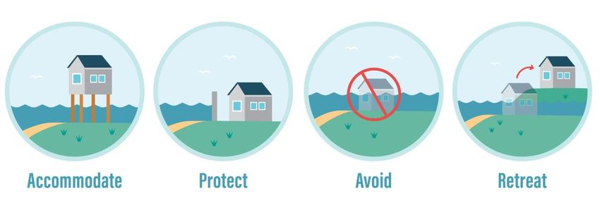
questions, to enable long term strategic planning and decision making for coastal management
(Figure 1, over page).

The Coastal Management Project focuses on the District’s coastline of Tasman Bay/Te Tai o Aorere
and Golden Bay/Mohua. This project currently excludes the west coast of the District from
Kahurangi Point (including Whanganui Inlet) to Farewell Spit and Port Pūponga as there is limited
hazard information, sparse population, limited access and minimal pressure for coastal development
in this area.

          Figure 1: The 10-step decision cycle, grouped around five questions (MfE, 2017)

Phase 1 of the project (July – September 2019) focussed on the key question of ‘What is happening?’
(Steps 1 and 2 in Figure 1). It involved undertaking community engagement focussing on the release
of Council’s coastal hazards map viewer, an online map tool which illustrates increments of sea level
rise up to 2.0 m, coastal storm-tide inundation and coastal erosion hazards. The engagement also
sought to raise awareness amongst our community and develop a common understanding of the
information. Feedback was sought on what the community values that may be affected by sea level
rise and coastal hazards to help inform the Phase 2 project (Step 3 in Figure 1). The coastal hazards
map viewer and associated reports are available on the Council’s website at tasman.govt.nz/coastal-
management.

Phase 2 focussed on the key question of ‘What matters most?’ (Steps 3 and 4 in Figure 1). Along
with the feedback gathered during the 2019 engagement (Step 3), it included preparation of a ‘first-
pass’ risk assessment (Step 4). The risk assessment is used to better understand Tasman Bay/Te Tai
o Aorere and Golden Bay/Mohua’s vulnerability to coastal storm inundation and sea level rise. The
assessment identifies a selection of assets, property, infrastructure and facilities, referred to as
‘elements at risk’, that may be exposed to coastal storm inundation and sea level rise using readily
available datasets. The report ‘Coastal Risk Assessment for Tasman Bay/Te Tai o Aorere and Golden
Bay/Mohua (December 2020)’ is available on the Council’s website using the webpage link above.

                                                 8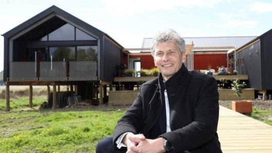
Understanding the values that individuals, iwi and our communities place on the coastal area, and
the vulnerability and risk of these values, will be an ongoing process. This recognises that there will
be other things that are valued by the community which are located at the coast that have not yet
been captured within work completed to date. In particular, there will be a range of special values
that Te Tai Ihu iwi hold for the places, the resources, and the history of the District. The Council will
continue to work in partnership with Te Tau Ihu iwi via the Council’s TEP Partnership Working Group,
set up to facilitate partnership working on development of the Aorere ki uta, Aorere ki tai - Tasman
Environment Plan (TEP), our second generation resource management plan.

Following the MfE 2017 Guidance, this report represents the start of the Phase 3 project focussing
on the key question of ‘What can we do about it?’ (Step 5 in Figure 1).

1.3 Key Terms
The natural hazards and climate change topics are complex and include a wide range of terms and
technical jargon. Appendix A sets out some key terms that used within this report. Understanding
what they mean will help to aid our future discussions on coastal management options. These key
terms are: natural hazards, risk, climate change mitigation and adaptation, and resilience.

2.    Legislative Framework
This section sets out a summary of the current and proposed legislative framework for natural
hazards management and responding to climate change. Appendix B provides further information.
Our legislative requirements set the context for considering high-level options for coastal
management as discussed in Section 5.

2.1 Existing Legislative Framework
2.1.1 Resource Management Act 1991
Under the Resource Management Act 1991 (RMA 1991) councils are required to recognise and
provide for the management of significant risks from natural hazards as a matter of national
importance (s6(h)) and to have particular regard to the effects of climate change (s7(i)).

In addition to these Section 6 and 7 matters, regional policy statements, regional and district plans
are required to give effect to other national directives including the New Zealand Coastal Policy
Statement 2010 (NZCPS). The NZCPS details national objectives and policies for the management of
the coastal environment, including responding to coastal hazards and sea level rise. NZCPS Objective
5 seeks to ensure that the management of coastal hazards is risk based and takes account of climate
change. It requires proactive management: locating new development away from hazard prone
areas; considering managed retreat for existing hazard-prone development; and protecting and
restoring natural defences. This objective primarily gives rise to NZCPS Policies 24 to 27 which are
detailed in Appendix C. The NZCPS provides directive guidance on the appropriateness of some
coastal management options, and this is discussed further in Section 5.

The Council has started work on its second-generation resource management plan, known as Aorere
ki uta Aorere ki tai - Tasman Environment Plan, which will replace the current Tasman Resource
Management Plan. The planning outputs from this Coastal Management Project will be used to
inform the natural hazards and climate change sections of the new plan.

2.1.2 Climate Change Response Act 2002
As required under the Climate Change Response Act 2002 and amendments, the Ministry for the
Environment published the first National Climate Change Risk Assessment for New Zealand

                                                   9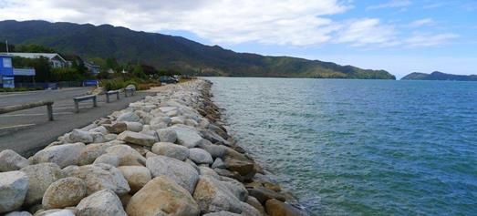
Arotakenga Tūraru mō te Huringa Āhuarangi o Āotearoa in August 2020. It identifies 43 priority risks
from climate change across five value domains (natural environment, human, economy, built
environment and governance) and highlights the 10 most significant risks. The risk assessment will
enable central government to prioritise action to respond to the risks identified, including through
the development of a National Adaptation Plan (MfE, 2020). At the time of writing, MfE is currently
working on the first National Adaptation Plan which will be published by August 2022. It is likely that
councils will play a role in its implementation, which may influence future phases of the Coastal
Management Project.

2.2 Resource Management System Reform
The Government is currently reforming the resource management system and proposes to repeal
the RMA 1991. One of the five objectives of the reform, which is key to this Coastal Management
Project, is to provide new legislation that will enable New Zealand to better prepare for adapting to
climate change and risks from natural hazards, and better mitigate emissions contributing to climate
change. It is proposed that the RMA 1991 will be replaced with three new pieces of legislation:
Natural and Built Environments Act (NBA); Strategic Planning Act (SPA); and Climate Adaptation Act
(CAA).

It is proposed that the NBA and SPA will be passed into law in this parliamentary term (i.e. by the
end of 2022), and the CAA will be progressed in this time too1. This reform proposes significant and
fundamental changes to resource management in New Zealand. The proposed changes are
designed to ensure that the resource management legislative framework is fit for purpose and
ultimately, ensure that our communities are resilient in the face of natural hazards and climate
change risks. The forthcoming legislation will significantly influence future phases of the Coastal
Management Project.

3.    Natural Hazards and Sea Level Rise
This section summarises the natural hazards that may occur within the coastal areas of our District
and the challenges we face with rising sea levels. Understanding these natural hazards (our natural
hazard ‘issues’) provides key context when considering future options for coastal management. This
section should be read in conjunction with the use of the Council’s coastal hazards map viewer
which illustrates increments of sea level rise up to 2.0 m, coastal inundation and coastal erosion
hazards.

3.1 Vulnerability to Coastal Storm Inundation
Many low-lying parts of our District’s coastline have already experienced coastal storm inundation.
For example, ex-tropical cyclone Fehi was a significant storm event that impacted our district on 1
February 2018. The storm surge coincided with a very high spring tide elevating sea levels. Large
waves further elevated sea levels and damaged the coastline and flooded roads, reserves and
nearby properties and houses. Sea level rise will increase the exposure of our coastal land to these
type of storm events, creating new hazards in areas that have not previously been exposed.

With a changing climate the frequency of coastal storm inundation events will increase
(Parliamentary Commissioner for the Environment, 2015). Rising sea levels will further exacerbate
the impacts of such storms.

1
  Ministry for the Environment website, viewed on 12/07/20. (https://environment.govt.nz/what-government-
is-doing/key-initiatives/resource-management-system-reform/overview/#the-way-forward-for-reform).

                                                   10
3.2 Vulnerability to Coastal Erosion
Our sandy beaches and shorelines are subject to natural processes of coastal erosion (sediment loss)
and coastal accretion (sediment gain). Beaches or shorelines will often experience a cycle of erosion
followed by accretion, with the duration of the erosion-accretion phase ranging from weeks (the
period of a storm event and post-storm recovery) to longer periods over a year(s), a decade or
several decades. The Council’s coastal hazards map viewer shows areas of historical coastal erosion
(sediment loss) and accretion (sediment gain), based on a 30+ year record.
How erosion trends or rates will change as sea levels rise into future is uncertain. However, it is
expected that for most localities erosion rates will increase and areas of accretion will begin to
exhibit an erosional trend. While coastal erosion will be exacerbated by sea level rise, it will remain
a localised hazard affecting frontline properties in some locations. As rising sea levels progress,
coastal inundation hazard will remain the more spatially extensive coastal hazard.
3.3 The Uncertainty of Sea Level Rise
Historic sea level rise in New Zealand has averaged 1.78mm per year, with the Port Nelson tide
gauge recording a slightly lower rate than the national average of 1.57mm per year (MfE, 2017). Sea
levels measured at Port Nelson in 2017 (averaged over the period 2008 to 2017) are now 150mm
higher than sea levels measured 75 years earlier in 1942 (averaged over the period 1939 to 1942)
(NIWA, 2018). Much of the observed sea level rise has occurred in the latter part of this period.
Many factors need to be taken into account when considering how future global warming will
contribute to climate change and, ultimately, sea level rise. The scientific consensus is that sea
levels will continue to rise and are likely to rise at an accelerated rate over time. As the earth’s
temperature rises, changes could happen sooner than predicted, or there may be changes to
emission rates that reduce the rate of warming in the longer term. However the future unfolds,
there will be a component of sea level rise caused by the emissions to date. This is despite any
recent or near-future measures to reduce emissions given the amount of greenhouse gases currently
in the atmosphere (from historical emissions) and the ongoing lagged response to sea level rise
(MfE, 2017).
The MfE 2017 Guidance outlines the approximate years, from possible earliest to latest, when
specific sea level rise increments (in metres above 1986-2005 baseline) could be reached for various
projection scenarios of sea level rise for the wider New Zealand region, as shown in Table 1 (over
page).
The representative concentration pathways (RCPs) listed are four comparable scenarios used to
predict how future global warming may contribute to climate change and sea level rise. The lower
scenario (RCP2.6) represents the rise in sea level if the Paris Agreement measures to control
emissions are achieved and keep global average temperatures well below 2° C above pre-industrial
levels, while pursuing efforts to limit the temperature increase to 1.5° C. The upper scenario (RCP8.5
H+) represents continuing high emissions and no effective emissions mitigation, plus runaway
instabilities in polar ice sheet melting. The other two scenarios (RCP8.5 and RCP4.5) are in between
those two different futures. For example, based on current information we may expect 1m sea level
rise by the years 2100 (RCP8.5+), 2115 (RCP8.5), 2170 (RCP4.5) or beyond 2200 (RCP2.6).
Given that the rate and magnitude of future sea level rise is uncertain, all four RCP scenarios should
be considered when developing our long-term adaptive planning approach. The timing of each
increment of sea level rise will depend on the rate of future global warming and climate change.
11Table 1: Approximate years, from possible earliest to latest, when specific sea level rise
increments (metres above 1986-2005 baseline) could be reached for various projection scenarios
of sea level rise for the wider New Zealand region (Source: MfE, 2017 (Table 11))
SLR Year achieved for Year achieved for Year achieved for Year achieved for
(metres) RCP8.5 H+ (83%ile) RCP8.5 (median) RCP4.5 (median) RCP2.6 (median)
0.3 2045 2050 2060 2070
0.4 2055 2065 2075 2090
0.5 2060 2075 2090 2110
0.6 2070 2085 2110 2130
0.7 2075 2090 2125 2155
0.8 2085 2100 2140 2175
0.9 2090 2110 2155 2200
1.0 2100 2115 2170 >2200
1.2 2110 2130 2200 >2200
1.5 2130 2160 >2200 >2200
1.8 2145 2180 >2200 >2200
1.9 2150 2195 >2200 >2200
Note: The Council relies on national sea level rise data provided by the Ministry for the Environment (MfE).
Following the release of the Intergovernmental Panel on Climate Change’s Sixth Assessment Report (August
2021), the Council will update the information contained in Table 1 when updated national sea level rise rates
are released by MfE.
3.4 Other Natural Hazards in the Coastal Area
The coastal area is the interface between land and sea. It is a dynamic environment where a
number of natural hazard processes can occur, either individually or in combination. While the focus
of the Coastal Management Project is on coastal hazards (seawater inundation and erosion) and sea
level rise, there are other natural hazards that may impact coastal areas, including:
• freshwater inundation (river flooding and incident rainfall/stormwater flooding)
• rising groundwater levels
• earthquakes
• seismic liquefaction
• tsunami
The combined effects of these natural hazards (where known) should be considered holistically
when considering coastal management options. Additionally, sea level rise will increase the
exposure of our coastal land to some of these hazards, creating new hazards in areas that have not
previously been exposed. For example, as sea levels rise coastal groundwater levels will also rise,
and depending on the underlying geology, areas susceptible to seismic liquefaction may increase.
The Council’s report ‘Coastal Hazards Assessment in Tasman Bay/Te Tai o Aorere and Golden
Bay/Mohua (July 2019)’ provides further detail on each of these natural hazards within the Tasman
District’s coastal areas.
It is recognised that there are other climate change effects that impact on the marine environment
(e.g. marine heat waves, ocean acidification) which is beyond the scope of this report.
4. Planning for the Uncertainty of Sea Level Rise
4.1 Planning for Uncertainty
New Zealand’s coastal cities and towns developed in the coastal area over time under the
presumption of a stable sea level (e.g. no consideration of changes in sea level). Assets such as
12homes, roads, airports, and three waters2 infrastructure were built based on a historical
understanding of the reach of tides and occasional flooding during storms (PCE, 2015).
While there is much uncertainty around the rate and magnitude of sea level rise, we do know that
rising sea levels will have increasing implications for development and infrastructure in coastal areas
along with environmental, cultural and societal effects. Therefore, regardless of this uncertainty we
need to be proactive in our long-term adaptive planning for sea level rise to ensure our communities
are resilient. The decisions we make today will affect our children, grandchildren and future
communities. This is because many land use planning, asset and infrastructure decisions that are
made today have long lifetimes, as follows:
Houses
Not less than 50 years (Building Act 2004) but more like 80-100+ years
Infrastructure
80 years (average)
Roads
Road – 50 years (average)
Bridge – 100 years (average)
Road corridor – permanent
Subdivision
Permanent
Consideration of coastal hazards and sea level rise has been embedded in the Council’s work
programmes for a number of years, as discussed in the case studies in Section 5.
4.2 Dynamic Adaptive Policy Pathways (DAPP)
4.2.1 What is DAPP?
Given the uncertainty of planning for sea level rise, decision-making processes need to avoid ‘locking
in’ decisions that cannot be changed if they become no longer fit for purpose. The dynamic adaptive
policy pathways (DAPP) approach is one such planning tool that designs strategies that are adaptive
and robust over different scenarios into the future.
DAPP is based on developing a series of actions over time (pathways) and developing triggers to
determine which pathway should be followed (see Figure 2 over page). There is no timeframe
associated with each action but there is an agreed point at which a particular situation is no longer
acceptable. From this, a plan can be developed to enable the preferred option or pathway when a
change is required. An adaptive approach means no investment is required until necessary but it
means we know what will happen if we get there (Auckland Council, 2021; Hurunui District Council,
2020; MfE, 2017). More information on the DAPP approach is set out in Section 9.3.3 and Appendix
G of the MfE 2017 Guidance.
2
Water, wastewater and stormwater infrastructure.
13Figure 2: Example of an adaption pathways map (Source: Auckland Council, 2021)
An example of the DAPP approach using Figure 2, is the scenario of an existing coastal road which
will become inundated every high tide under a 1.0 m sea level rise (current situation). The different
actions (and pathways) could include building a hard protection structure to protect the road (Action
B), raising the height of the road (Action C), or retreating/relocating the road inland (Action A or D).
Trigger points could be at 0.3m and 0.6m sea level rise or frequency of significant road damage
during storm events. At these points either additional or different actions could be taken via an
alternative pathway to avoid reaching the threshold at which the road is no longer useable. Raising
and protecting the road could be short to medium term actions, used individually or in combination.
While the road could be relocated inland at any time, a preference may be given to protect the road
for the near future with an understanding that relocation is the preferred action (pathway) in the
longer term.
The MfE 2017 Guidance incorporates the principles of DAPP in its iterative 10 step-framework (see
Figure 1). While the Guidance’s framework presents an innovative process for coastal management,
with the community at the heart of this decision-making, it also presents a number of challenges. For
example, the process to identify and agree to a set of long-term options that span decades and have
implications for future generations, may be constrained given that current local government
decision-making processes operate under a three yearly cycle and funding decisions are based on a
10 year cycle under the Long Term Plan. Central government has signalled through the reform of
the RMA 1991 that the development of a Climate Adaptation Act will address some of these
challenges, such as the complex legal and technical issues associated with managed retreat and
funding and financing adaptation. Both the RMA 1991 reform and the release of the National
Adaptation Plan (by August 2022) will significantly influence future phases of the Coastal
Management Project (see Section 2 for more information).
4.2.2 Using DAPP in Tasman
As we work towards developing our long-term adaptive planning for sea level rise and coastal
hazards, the use of DAPP will be helpful where it is likely that a combination of options may be
required over time (DAPP pathways) in some of our low-lying coastal areas. Using tools such as
DAPP will enable our adaptive planning to remain robust over different scenarios of future climate
change, and in particular sea level rise. This will ensure that we avoid ‘locking in’ decisions that
cannot be changed if they are no longer fit for purpose. In circumstances where our coastal
management options are limited due to immediate issues with coastal hazards, there may be other
approaches or planning tools that could be more appropriate.
14Next steps in the Coastal Management Project will include identifying the range of options
applicable in specific locations around Tasman, and their respective costs, benefits and potential
adverse effects – and which are acceptable or not. Initially, this work may involve developing a
planning response to limit and/or control further development in high hazard areas, while we
continue to work towards long-term adaptive planning (such as the use of DAPP pathways and
trigger points, or other planning tools). The best way to minimise and reduce coastal hazard risk will
be to avoid areas that are, or will become, exposed to hazards.
The Council is already starting to incorporate the principles of DAPP in its resource and building
consenting processes. For example, in 2019 the Council received an application to subdivide low-
lying coastal land that is zoned light industrial. Given the proximity of the site to the coast and
predicted future sea level rise (as shown on the Council’s coastal hazards map viewer), it was clear
that the site is subject coastal hazards within the next 100 years. A natural hazards assessment
provided by the applicant concluded that whilst the site is suitable for light industrial use over the
medium term as the hazards can be mitigated, long-term managed retreat is required (the preferred
DAPP pathway). The applicant proposed the use of a Consent Notice whereby the title holders of the
subdivided lots no longer have property rights once sea level rises 0.8 metres (the DAPP trigger point
adopted for this site). This requirement facilitates the managed retreat of the occupying businesses
once the trigger point is reached, including the removal of all structures, waste and contaminants,
and site remediation.
5 Coastal Management Options
5.1 Introduction
This section sets out a range of options for coastal management to respond to sea level rise and
coastal hazards. The options are grouped into four categories: accommodate, protect, avoid, and
retreat (Figure 3). Initially, it is important to look at each of these options at a regional level, to
understand the range of possible coastal management responses. There are a range of coastal
management measures (options) implemented within our District, while others may need careful
consideration to understand their suitability. Some potential barriers and risks associated with
implementation of the options are also identified and discussed in this section, including the broader
legislative context.
Figure 3: Coastal management options can be grouped into four high-level categories
15The range of options listed is not exhaustive and it is recognised that there may be alternative
options that are not identified. Through our community discussions during this phase of work, we
want to understand if there are alternative options or ideas for coastal management that we should
consider. This will ensure that we avoid narrowing down the options too early in the process. Next
steps in the Coastal Management Project will include identifying specific options and
recommendations at the local level.
Each option has different costs, implications, effectiveness, and lifespans. Some options may only
provide for a short or medium term response, while others will have greater longevity and will
provide a more permanent solution to the hazard. Some options will be ‘quick wins’ to implement,
while other options, such as retreat, will require significant forward planning. The options presented
relate to both new development and intensification within existing developed areas.
As recommended by the MfE 2017 Guidance, any consideration of options will require input from a
range of community interests including landowners, iwi, council staff and technical experts, and the
wider community. As we have these coastal conversations, it is important that we manage our
expectations. Options that may be preferred by individuals or groups may not be automatically
included in our long-term adaptive planning if they have significant environmental, cultural, or socio-
economic impacts. Any discussions on coastal management options should be framed within the
context of:
• Statutory requirements (e.g. Resource Management Act 1991 and New Zealand Coastal Policy
Statement 2010, or any future legislation)
• Iwi and Māori relationships with the coastal environment and iwi management plans
• Community values and objectives
• Understanding what risk our regional and local communities are willing to live with - acceptable,
tolerable, and intolerable
• Private benefit and costs versus public benefit and costs
• Feasibility and burden of cost (either now and/or in the future) and who pays
The following sub-sections provide a summary of options within each grouping and case studies
from within our District.
5.2 Accommodate
The ‘accommodate’ grouping is a set of options that enable continued use
of coastal land but existing development is adjusted or new development
is designed to anticipate coastal hazards. Examples include raising ground
and/or floor levels of buildings, requiring relocatable houses, or providing
alternative inundation pathways (MfE, 2017). Accommodate options can
make use of new technologies and innovation.
A key issue with some of the accommodate options, particularly raising
floor levels, is that they are unlikely to be viable with progressively rising
sea levels. While houses could continue to be raised above the maximum
expected sea and storm level, infrastructure servicing will become
problematic and costly, particularly road access.
The Council already implements some of these accommodate options through our resource and
building consent processes, as discussed in Case Studies 1 and 2.
16CASE STUDY 1: Nelson Tasman Inundation Practice Note 2019
Council’s Inundation Practice Note provides non-statutory guidance to determine minimum
ground and floor levels for subdivision, new buildings, and major alterations to existing
buildings in inundation prone areas. The practice note provides guidance to support Tasman
District Council and Nelson City Council building and resource consent processes. The
guidance ensures that new buildings and major alterations are built to mitigate a 1% annual
exceedance probability (AEP) inundation ‘design event’ for seawater and/or freshwater
inundation. A 1% AEP inundation event has a 1% chance of occurring in any year.
In coastal locations, the practice note also includes consideration of at least 100 years of
projected sea level rise, following the MfE 2017 Guidance. Application of the practice note
ensures that new buildings and major alterations to existing buildings are designed in a way
that allows buildings to remain resilient from inundation over the expected lifetime of the
building, taking into consideration climate change effects. The Inundation Practice Note can
be viewed on the Council’s website (https://www.tasman.govt.nz/my-council/key-
documents/more/growth/land-development-manual/).
Resource and building consent decisions are made with the most up to date natural hazards
and sea level rise data available at the time they are granted. Consequently, a building
constructed today may have different requirements for minimum ground and/or floor levels in
comparison to a building constructed 15 years ago, because of improved local data (such as
modelling) and updated national sea level rise guidance. There will also be a range of local
factors that will influence site specific minimum ground and/or floor level requirements, which
means comparisons cannot always be made between sites in close proximity, including within
local neighbourhoods. Local factors can include site topography, existing hazard mitigation
works or infrastructure, and the design life of the building. Some resource consents may
include specific conditions to address the hazard risk. Sometimes there will be a time lag
between when a consent is granted and when the consent holder chooses to implement it.
17CASE STUDY 2: Relocatable Houses
In our district there have been a small number of relocatable houses built in coastal
locations in recent years, recognising the site specific natural hazards risks these locations
are subject to over the longer term.
One example is a relocatable house built adjacent to the Coastal Highway and the Moutere
Inlet which featured on the TV programme ‘Grand Designs New Zealand’ (Stuff, 2017). In 2017,
the Council received a resource consent application to construct this house on very low-lying
land. Parts of the site are just at, or slightly above, current mean high water springs (MWHS)
and the setback between the proposed house and MHWS was only 7 metres at the closest
point. As such, the development is subject to seawater inundation and erosion hazard and
required mitigation.
The habitable parts of the house were designed to be relocatable so they can be moved if sea
level rise makes occupation of the site untenable. The foundation of the house is
constructed from durable material to mitigate the effects that inundation will have on the
house in the medium term. Through the building consent process, the Council required that a
hazard notice be placed on the property title (under sections 72 and 73 of the Building Act
2004). This notice warns future property owners of the natural hazard risk which, from a
legal perspective, provides some protection for Council if there is subsequent damage as a
result of the natural hazard.
Grand Designs New Zealand host,
Chris Moller, outside the Moutere
Inlet relocatable house.
(Photo credit: Mediaworks)
5.3 Protect
The ‘protect’ grouping is a set of options that ‘hold the line’. It includes
soft and hard options to protect coastal areas from the sea as discussed
below. The use of soft and/or hard protection signals that there will be
investment to protect an area for longer, at least as an initial part of a
longer-term strategy. This recognises there will likely be a need for
retreat or enhanced or alternative protection at some point in the future
(MfE, 2017).
18From a legislative perspective, the NZCPS provides clear guidance on the suitability of both soft and
hard protection options. The NZCPS discourages the use of hard protection structures (Policy 25) and
promotes the use of alternatives including natural defences/soft protection (Policy 26). In relation to
protecting significant existing development from coastal hazards, Policy 27 prefers strategies that
reduce the need for hard protection structures and similar engineering interventions. Appendix C
sets out NZCPS Policies 25-27.
5.3.1 Soft protection
Soft protection options include a range of measures such as dune and beach
nourishment/replenishment (e.g. sand push-ups) and wetland restoration and enhancement. Soft
protection can assist in reducing the impacts of natural hazards on coastal development while
protecting a number of other values including cultural, coastal habitats and species, landscapes,
public access and recreation. Case study 3 provides examples of soft protection measures
implemented in our District.
Over time, soft protection options may experience erosion as part of natural coastal processes. For
example, a coastal storm tide may erode a sand push-up exposing nearshore coastal land. In such
instances while it may appear that the sand push-up is not working, this is exactly what is intended
as they act as a natural buffer protecting the land behind, rather than the land being eroded.
Following large storm events, push-ups can be undertaken again to reinstate the sand.
CASE STUDY 3: TORRENT BAY SAND PUSH UPS
Soft protection shoreline management is successfully undertaken at a number of locations in
the District through sand push-ups and plantings/Coastcare projects. In recent years, resource
consents for sand push-ups have been granted in areas such as Pakawau, Torrent Bay, and
Little Kaiteriteri in response to coastal erosion.
Torrent Bay beach within the Abel Tasman National Park experiences periodic erosion as a
result of storms and ongoing wave action. The erosion may impact on the back-beach dune
planting, public access routes and ultimately private property. The Council periodically
undertakes replenishment of the beach from the lower foreshore to the upper foreshore.
Beach replenishment work is usually undertaken every 2-3 years on average, depending on the
frequency of storm events. This activity has been undertaken since 2005 and has effectively
mitigated the erosion issues to date. These sand push-ups are funded through a mix of
targeted rates on Torrent Bay landowners and wider Council funding.
19While soft protection measures provide a range of positive environmental benefits, from a hazard
mitigation perspective it is likely that such measures will only be a short to medium term option
providing localised protection for nearshore coastal land. Over the long-term, this option may
become unsustainable as sea levels rise, accelerating coastal processes.
5.3.2 Hard Protection
This option includes hard structural measures such as coastal protection structures, groynes,
stopbanks, tide banks, and causeways. Coastal protection structures can be made out of a range of
materials, which include sloping-faced rock and concrete block revetments, vertical or near-vertical
timber and concrete walls – these are all more commonly referred to as ‘sea walls’. Hard protection
measures modify natural coastal processes on beaches and nearshore coastal land. Their purpose is
to deter or prevent coastal erosion or inundation affecting those coastal areas they are built to
protect (e.g. the built environment and/or coastal land uses) over the short to medium term.
However, they tend to shift these issues to other parts of the coast and this needs to be considered
in their suitability as an option.
For many coastal landowners and communities around New Zealand, a common response to the
increasing risk from coastal hazards and sea level rise is to ‘harden the coasts’ to defend property –
particularly the use of coastal protection structures (e.g. sea walls) (Storey et al, 2020). However,
there can be many environmental and social costs over the longer term in taking this approach. The
location of a hard protection structure, and how coastal processes respond to the placement of that
structure, may result in the degradation of the natural, cultural, ecological, access and recreational
values of beaches (including the loss of the high tide beach). The use of hard protection can also
result in unintended outcomes, adverse environmental effects (including ‘end wall effects’ for sea
walls affecting adjacent properties), implications for liability, and in some circumstances the use
(and/or loss) of public land for private benefit.
Hard protection measures are expensive to build and maintain. Their costs will vary depending on
location and design, but a project may be multi-million dollars for construction, with additional
ongoing maintenance costs. The associated costs must be a key factor in any decision-making
process when considering their use. This is particularly so given that Storey et al (2020) notes that
hard protection measures (such as sea walls) will only delay damage, and are likely to be
counterproductive as they can encourage further intensification of development in vulnerable
coastal areas.
NZCPS Policy 27 sets out strategies for protecting significant existing development from coastal
hazards, focusing on promoting and identifying long-term sustainable risk reduction approaches.
The Policy acknowledges that hard protection structures may provide a role in protecting important
built infrastructure that needs to be at the coast for functional reasons or where there is no viable
alternative (e.g. major infrastructure such as the national electric power transmission grid, state
highways, ports and airports). However, several parts of Policy 27 focus on discouraging the use of
hard protection structures in relation to private property, particularly where it is proposed on public
land and there is no significant public or environmental benefit in doing so. In circumstances where
hard protection structures may be considered necessary, this should form an initial part of a longer-
term strategy, until there is an opportunity for relocation or redevelopment to reduce vulnerability,
which in turn would reduce the need for hard protection structures over time (Department of
Conservation, 2017).
Case Study 4 details examples of hard protection measures used in our District, while Case Study 5
sets out the Council’s current policy approach for the use of hard protection measures.
20CASE STUDY 4: HARD PROTECTION STRUCTURES
Along the Tasman Bay/Te Tai o Aorere and Golden Bay/Mohua coastline, there are a number of
hard protection structures built on both public and private property to protect land, buildings
and/or community assets (roads, parks and reserves, etc.) from coastal erosion and/or
inundation from present day high tides. Council-owned hard protection structures were
historically built to mitigate coastal erosion only (not inundation).
Locations of protection structures include coastal urban areas (e.g. Ruby Bay, Mārahau,
Collingwood), and both farmland and industrial land adjacent to the Waimea Inlet, coastal
farmland near Riwaka, and coastal farmland at Ferntown (near Collingwood). These structures
are built from a variety of materials. At some low-lying rural locations, behind tide banks and
areas where drainage is compromised by high tide levels, pumps are also used to control or
reduce water levels.
Both Council-owned and privately owned hard protection structures that have resource
consents often allow maintenance to occur as required. However, their presence is uncertain
beyond the consent expiry date. There are some privately erected structures along the
coastline that do not have formal authorisation and similarly, there is no certainty that they will
continue to function in a protective capacity into the future. General issues such as the removal
of structures when they are no longer working and who pays (‘end of life costs’) will become
more problematic as sea levels rise.
Between 2003 and 2007, the Council, in conjunction with the local community, completed
substantial coastal protection at Mārahau and Ruby Bay (Broadsea Avenue and Old Mill
Walkway). These have been constructed to protect existing urban development and are built to
a higher standard than earlier works at these locations.
The photo above shows a section of the Sandy Bay-Mārahau Road which has hard protection,
enabling ongoing access to Mārahau and Abel Tasman National Park.
21You can also read