Report to inform Screening for Appropriate Assessment Glanmire Road Improvements and Sustainable Transport Works, Co. Cork - Cork County ...
←
→
Page content transcription
If your browser does not render page correctly, please read the page content below

Report to inform Screening for Appropriate Assessment

Glanmire Road Improvements and Sustainable
Transport Works, Co. Cork

Project Number: 60559532

3 May 2018

Revision 4
Report to Inform Screening for Appropriate Assessment

Quality information
Prepared by                                   Checked by                          Approved by

Robert Fennelly                               Dr Miles Newman                     Dr Eleanor Ballard
Principal Ecologist                           Consultant Ecologist                Associate Director (of Ecology)

Revision History
Revision               Revision date          Details                Authorized   Name                Position

Rev0                   27 Feb 2018            Draft issue for CCC Yes             Robert Fennelly     Principal Ecologist
                                              comment

Rev1                   13 Mar 2018            Minor changes to       Yes          Robert Fennelly     Principal Ecologist
                                              address client
                                              comments

Rev2                   13 April 2018          Revised for Cork       Yes          Robert Fennelly     Principal Ecologist
                                              County Council
                                              comments; version
                                              for planning
                                              purposes

Rev3                   26 April 2018          Revised for            Yes          Robert Fennelly     Principal Ecologist
                                              drainage input
                                              statement

Rev4                   03 May 2018            Minor revisions        Yes          Robert Fennelly     Principal Ecologist
                                              prior to planning
                                              issue

Distribution List
# Hard Copies          PDF Required           Association / Company Name

Prepared for:                                                                                                       AECOM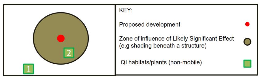
Report to Inform Screening for Appropriate Assessment

Prepared for:
Prepared for:

Cork County Council

Prepared by:
AECOM Ireland Limited
1st Floor, Montrose House
Douglas Business Centre
Carrigaline Road
Douglas,
Co. Cork T12H90H

T +353-(0)21-436-5006
aecom.com

© 2018 AECOM Ireland Limited. All Rights Reserved.

This document has been prepared by AECOM Ireland Limited (“AECOM”) for sole use of our client (the “Client”)
in accordance with generally accepted consultancy principles, the budget for fees and the terms of reference
agreed between AECOM and the Client. Any information provided by third parties and referred to herein has not
been checked or verified by AECOM, unless otherwise expressly stated in the document. No third party may rely
upon this document without the prior and express written agreement of AECOM.

Prepared for:                                                                                          AECOM
Report to Inform Screening for Appropriate Assessment

Table of Contents
1.        Introduction .................................................................................................................................................. 1
          1.1        Purpose of this Report ...................................................................................................................... 1
          1.2        Legal and Planning Context .............................................................................................................. 1
          1.3        European Sites ................................................................................................................................. 1
2.        Project Description ....................................................................................................................................... 3
          2.1.1 River Crossings ................................................................................................................................ 3
          2.1.2 Lighting ............................................................................................................................................. 3
          2.1.3 Drainage ........................................................................................................................................... 3
          2.1.4 Construction Management................................................................................................................ 3
          2.1.5 Avoidance of Instream Work ............................................................................................................. 4
          2.2        Key aspects of individual projects ..................................................................................................... 4
3.        Methodology ................................................................................................................................................ 7
          3.1        Guidance .......................................................................................................................................... 7
          3.2        Desktop and Field Surveys ............................................................................................................... 7
          3.3        Steps in Screening ........................................................................................................................... 8
          3.3.1 Linkages with European Sites .......................................................................................................... 8
          3.3.2 Zones of Influence and Proximity to Identify Relevant Sites ............................................................. 8
          3.4        Scoping of Effects ........................................................................................................................... 12
          3.5        The Precautionary Principle ............................................................................................................ 12
4.        Baseline Description .................................................................................................................................. 13
          4.1        European Sites ............................................................................................................................... 13
          4.2        Habitats .......................................................................................................................................... 15
          4.2.1 Overview......................................................................................................................................... 15
          4.2.2 Terrestrial Habitats .......................................................................................................................... 15
          4.2.3 Wetland Habitats, Surface Waters, and Groundwater .................................................................... 16
5.        Screening Assessment .............................................................................................................................. 17
          5.1        Is AA Screening Required? ............................................................................................................. 17
          5.2        Summary of Information Required .................................................................................................. 17
          5.3        Screening Assessment ................................................................................................................... 18
          5.3.1 Key Findings ................................................................................................................................... 18
          5.4        Summary of Screening Assessment (Proposed Development Alone) ............................................ 23
          5.5        In-Combination Effects ................................................................................................................... 23
          5.5.1 Planning Application Search ........................................................................................................... 23
          5.5.2 Land-use plans ............................................................................................................................... 24
          5.5.3 Pollution .......................................................................................................................................... 24
          5.5.4 Concluding remarks on In-Combination Effects .............................................................................. 24
6.        Overall Screening Conclusion .................................................................................................................... 25
References ............................................................................................................................................................ 26
Appendix A Figures ............................................................................................................................................... 28
Appendix B Complete Screening matrices ............................................................................................................ 29
          B.1        Key to Screening matrices .............................................................................................................. 30

Prepared for:                                                                                                                                                    AECOM
Report to Inform Screening for Appropriate Assessment Graphics Graphic 1. Relationship between zone of influence and QI habitats and plants which are not mobile .................... 9 Graphic 2. Relationship between zone of influence and QI fauna species which are not mobile, ........................... 9 Tables Table 1. Zones of Influence Estimated for potential effects from the proposed development ................................ 10 Table 2Conservation Objectives for Special Areas of Conservation Referenced in AA Screening Report ............ 13 Table 3Conservation Objectives for Special Protection Areas Referenced in AA Screening Report ..................... 14 Table 4. Invasive plant species recorded during site visits .................................................................................... 15 Table 5.Summary of information required to complete Screening assessment ..................................................... 17 Table 6 Key findings of Screening assessment for fauna species ......................................................................... 19 Table 7 Key findings of Screening assessment for habitats and plant species ..................................................... 22 Table 8 Screening assessment for QI fauna species: includes all species for which European sites are designated in Ireland ............................................................................................................................................................... 31 Table 9 Screening assessment for QI habitats and plant species: includes all habitats and plants for which European sites are designated in Ireland .............................................................................................................. 37 Prepared for: AECOM
Report to Inform Screening for Appropriate Assessment
1. Introduction
1.1 Purpose of this Report
AECOM Ireland Limited (hereafter referred to as AECOM) was asked by Cork County Council (hereafter referred
to as ‘the Client’) to produce this Appropriate Assessment (AA) Screening report to inform the Part 8 planning
package for the Glanmire Road Improvements and Sustainable Transport Works. This is hereafter referred to as
‘the proposed development’.
The proposed development is located within the townlands of Dunkettle, Ballinglanna, and Glanmire. This report
will be provided to Cork County Council (CCC) who is the competent authority for making determinations in
relation to Screening for AA under the legislation set out in Section 1.2.
1.2 Legal and Planning Context
Planning Context
The European Communities Habitats Directive 92/43/EEC (“the Habitats Directive”) provides, in Article 6 (3), the
1
legal basis for AA (and by proxy the legal basis for Screening for AA ) at European level. In the context of the
proposed development, the requirement (to screen for) AA under the Habitats Directive is transposed by the Act,
and the Planning and Development Regulations 2010 to 2016.
Under Section 177U (1) of the Planning Acts, a Screening for AA of the proposed development shall be carried
out by the competent authority (in this case, CCC) to assess in view of best scientific knowledge, if that proposed
development, individually or in combination with another plans or projects, is likely to have a significant effect (s)
on any European sites. The term ‘European site’ is defined in Section1.3.
Under Section 177U (5) of the Planning and Development Acts 2000-2010, as amended (‘the Planning Acts’), the
competent authority shall determine that an AA of a proposed development is required if it cannot be excluded
[emphasis added], on the basis of objective information, that the proposed development, individually or in
combination with other plans or projects, will have a significant effect on a European site (s).
Appropriate Assessment
An AA is triggered by an AA Screening determination which significant effects on European sites (defined in
2
Section 1.3) are likely (or more specifically ‘cannot be excluded on the basis of objective information ). If
triggered by Screening, the competent authority must complete an AA to determine whether the project will
adversely affect the integrity of any European site, in light of the site’s Conservation Objectives. The competent
authority’s AA is typically informed by a Natura Impact Statement requested from a technical expert.
Consultation and Publication Requirements
Section 177U (7) states: “A competent authority shall, as soon as may be after making a decision in relation to
the application for consent for proposed development, make available for inspection by members of the public
during office hours at the offices of the authority, and may also publish on the internet—any determination that it
makes under subsection (5), and reasons for that determination”.
1.3 European Sites
3
In the Republic of Ireland, European sites comprise:
Special Areas of Conservation (SAC) designated for habitats, plants, and non-bird species;
1
It is noted that there is, strictly speaking, no stated requirement to conduct Screening for AA in the Habitats Directive. The
requirement for Screening arose from guidance issued by the European Commission (EC, 2001), and was subsequently made
a statutory requirement in Irish law.
2
The’ Waddenzee’ ruling (C-127/02) is an influential judgement of the European Court of Justice (ECJ) which has clarified what
"likely to have a significant effect" means; specifically that, "if it cannot be excluded on the basis of objective information, that it
will have a significant effect on the site" and that unless a significant effect can be objectively ruled-out with certainty, then it is
'likely'.
3
“European site” replaced the term “Natura 2000 site” under the EU (Environmental Impact Assessment and Habitats)
Regulations 2011 S.I. No. 473 of 2011.
Prepared for: AECOMReport to Inform Screening for Appropriate Assessment Special Protection Areas (SPA) designated for bird species and their habitats; and, Candidate sites including ‘cSAC’. The process of designating cSAC as SAC is ongoing in Ireland. The term SAC is used throughout this report for both SAC and cSAC, given they are subject to equal protection. Prepared for: AECOM
Report to Inform Screening for Appropriate Assessment
2. Project Description
The proposed development is one of several initiatives of the Irish government to address significant public
infrastructure deficits, where the lack of infrastructure is considered to have hindered the development of
housing.
AECOM were appointed in November 2017 to provide consulting engineering services to Cork County Council for
the Glanmire Road Improvements and Sustainable Transport Works.
Whilst predominately relating to widening or improvement of existing public pathways and roadways, there are
significant ‘greenfield’ portions of the proposed path/cycleway which will require construction on previously
undeveloped land, in addition to a series of proposed crossings of the Glashaboy River.
The proposed development is divided into 20 individual ‘projects’ which have been illustrated in the overview map
Figure 1.
2.1.1 River Crossings
Project no. 15 would include the construction of a shared pedestrian path and cycle way (3-4 m width; hereafter
‘the cycleway’). These proposed cycleway crossings will require five new bridges:
Immediately north of the existing Glanmire Bridge (P16);
Circa 100m upstream of Glanmire Bridge, onto low-lying undeveloped floodplain to the west of the
Glashaboy River (P15);
Circa 200m upstream of Glanmire Bridge from the floodplain onto poorly drained scrubby grasslands
and gravel to the west of the Riverside Football Club (FC) playing pitches (P15).
Circa 500m upstream of Glanmire Bridge at the northern end of Riverside Football Club (FC) near an
existing weir, across to John O’Callaghan Park (P15);
Circa 300m upstream of the previous bridge, near the meeting of the Butlerstown and Glashaboy Rivers
where both banks are within John O’Callaghan Park (P15);
There will be no instream works in the Glashaboy or Butlerstown Rivers as all bridges will be clear span.
There will be no new structures across the Butlerstown River albeit several projects cross the River by existing
bridges.
2.1.2 Lighting
The design team has advised that lighting would be designed after Part 8 planning determination, subject to
approval, and would be designed in accordance with British Standard Code of Practice for the Design of Road
Lighting (BS 5489).
2.1.3 Drainage
The proposed road drainage will facilitate the efficient collection of surface water while minimising the impact of
runoff on the receiving environment. Where possible, the surface water will be attenuated prior to discharge. The
principle type of drainage system will consist of a piped network with kerb and gullies, which will be integrated
into the existing drainage network. Treatment will be provided in the form of hydrocarbon and silt inceptors. The
drainage will be designed in accordance with TII Standards and the requirements of Cork County Council.
2.1.4 Construction Management
A preliminary outline Construction and Environmental Management Plan (CEMP) has been produced and is
included with the Part 8 planning package. The minimum requirements in the preliminary outline CEMP will be
binding on the appointed contractor, who will develop a detailed CEMP prior to commencing construction.
Relevant measures in the CEMP which will adequately address pollution risks include:
Use of high performance silt fencing (Hy-Tex or similar) shown by independent academic research to be
the highest performing geotextile available as of 2013 (Liddon, 2013);
Prepared for: AECOMReport to Inform Screening for Appropriate Assessment
Installation of silt fencing to best practice published standards (Caraco, 2000);
Monitoring of silt fencing performance during construction to inform repair and improvements as
required.
2.1.5 Avoidance of Instream Work
As stated in the preliminary outline CEMP included in the Part 8 planning package, the design team has
confirmed there will be no instream works for the proposed development;
2.2 Key aspects of individual projects
Full details of the project description (including widths of pedestrian, cycleway, and road alignments, signage/ and
road marking requirements) are included within the Part 8 planning package. Projects may be refined during
detailed design and/or as a condition of planning. A summary of the key aspects of each project is provided
below:
Project No. 1 R639/Church Hill Junction;
Provision of a new right turn lane from the R639. To accommodate the layout the boundary wall of Cólaiste
an Phiarsaigh will be set back. The benefits associated with the proposal include a more efficient junction
which will provide higher levels of service for all users. Pedestrians will be provided with wider footways.
The bus stops will be relocated to provide for more direct connectivity with Cólaiste an Phiarsaigh. A
pedestrian crossing will support safer road conditions. Bus laybys will be provided so the efficiency of traffic
movement on the Glanmire Road is improved.
Project No. 2 Prohibit Right Turn M8 Merge;
This project will remove the right turn from Dunkettle Road onto the M8. The merging of traffic travelling
onto the slip road of the M8 Merge can lead to operational difficulties for traffic travelling on the M8. There is
also evidence that the Dunkettle Road is used a rat run for traffic seeking to get to avoid congestion at the
Dunkettle Interchange.
Project No. 3 Glanmire Bridge/Village;
This project will upgrade the existing road network on the R639, Glanmire Bridge and Glanmire Village. The
aim of the project is to reduce speeds within Glanmire Village to provide a safer road network for all road
users. The project will integrate with other proposals included within the project such as improvements to
R639/Church Hill Junction, the Proposed Greenway, Proposed Pedestrian Bridge and L2999 Dunkettle
Road Upgrades.
Project No. 4 R639/L3010/Old Youghal Road (Riverstown Crossroads);
This project will provide an improved layout at the R639/L3010 junction. The existing junction is a four arm
signalised junction. The proposal involves kerb realignments to increase the length of right turn lanes on
the R639. The layout will include proposals to improve accessibility to O’Callaghan Park with a new
entrance directly to the Park from the junction. This will also increase accessibility to Project No. 15
Proposed Greenway from Glanmire Community College to Cólaiste an Phiarsaigh via O’Callaghan Park.
1.75 m wide cycle lanes will be introduced on the R639 provided through the junction. A pedestrian and
cycle ramp is proposed form the signalised junction to access John O’Callaghan Park.
Project No. 5 R639/Hazelwood Road Junction;
This project will provide an improved layout at the R639/Hazelwood Road junction. The junction will be
signalised. The proposal involves kerb realignments to increase the length of right turn lanes and improved
pedestrians and cyclist facilities at the junction. The proposal provides greater cyclist provision at the
junction and will make it easier to incorporate cyclist improvements to Hazelwood Road.
The provision of 2m footways and 2.4m pedestrian crossings provided on all arms of the junction will
improve the safety of pedestrians through the junction.
Project No. 6 L3010/East Cliff Road Junction;
This project will provide an improved layout at the L3010/East Cliff Road junction. The junction will be
signalised to include for the connection to Project No. 8, a New Link Road from L3010 to Hazelwood Road.
Prepared for: AECOMReport to Inform Screening for Appropriate Assessment
Kerbs and footways will be realigned and resurfaced to improve conditions for pedestrians and cyclists. The
Proposed Greenway will join the carriageway at a new toucan crossing on the L3010.
Project No. 7 Riverstown Bridge;
A preliminary design option assessment report recommends that the existing bridge should be upgraded
with a shuttle system (i.e. a ‘give-way’ system). There will be no instream works required for this proposal.
Project No. 8 New Link Road (L3010 to Hazelwood Road);
This project will provide a new connection between the L3010 and Hazelwood Road. The benefit of this
project is that it will reduce the traffic demand on Riverstown Bridge (Project No.7) by providing an
alternative route from Riverstown Village. As part of Project 6, the junction between East Cliff Road and the
L3010 will be signalised, this new link road will form part of the new signalised junction. Parking will also be
provided along the new link road as minimal parking exists within Riverstown Village.
This project will remove mature trees, referred to through this report as the remnant wooded avenue to the
Riverstown House.
Project No. 9 L2999 Dunkettle Road;
This project will upgrade the L2999 Dunkettle Road. From Glanmire Village to the consented O’Flynn
development a 3m shared use footway/cycleway, a 6.5m carriageway and a 2m footway are provided. From
the O’Flynn Development to Gaelscoil Uí Drisceoil a wider cross section consisting of a 2m footway either
side of the carriageway, a 3m segregated cycle track, a 6.5m carriageway and 1m verge either side of the
carriageway will be provided.
There will be removal of some mature treelines (and demolition of two properties) within existing property
boundaries along the southern/western side of Dunkettle Road. A new cross-section along this improvement
within the Ballinglanna Estate lands, which provides for access to the consented O’Flynn Housing
development, is not included within the proposed development.
Project No.10 Flaring at Tivoli Roundabout;
This project will provide facilities to enable pedestrians and cyclists to safely negotiate Tivoli Roundabout.
Kerb realignment and resurfacing will also be provided to increase the capacity of the roundabout from the
R639 Southbound approach. There will be no instream works or removal of mature vegetation along the
banks of the Glashaboy River for this project.
Project No.12 R639/R615 Junction;
This project proposes a reorganisation of traffic movements at the junction of the R615 and R639. Left
turners from the R639 have significant difficulty making this movement as a consequence of the geometry
and gradient. As a result the proposal involves prohibiting the left turn and providing a right turn lane to
R615. Pedestrian crossing movements will be accommodated through the provision of a controlled
crossing at Project 5, R639/Hazelwood Road junction. Land acquisition will be required from to widen the
carriageway from Glanmire GAA club. The proposed land acquisition will not impact the outline of the
existing football pitch.
Project No.13 Brook Inn Junction
This project proposes formalising the junction between the R639 and the L96391-0. The existing layout
consists of two access roads joining the R639. Formalising the junction will improve safety for vehicular
movements. As part of the works the existing bus layby will be formalised and pedestrian provision
improved. The width of the carriageway on the R639 will be reduced to 6.5m. Reducing the carriageway
width will reduce speeds on approach to Sallybrook and the “Green Space” provides additional areas for
landscaping. The treatment acts as a gateway feature at the entrance point to Sallybrook. Parking will be
provided at the entrance to The Brook Inn, the hardstanding also acts as a delivery area for The Brook Inn.
Project No. 14 Footway Improvements Fernwood to Riverstown;
This project will involve upgrading the footways from the residential estate ‘Fernwood’ along the East Cliff
Road. Street lighting will be provided on footway network from the entrance to Fernwood to Riverstown to
improve the perception of safety on the route and will encourage people to use the improved facility.
Project No. 15 Proposed Greenway;
Prepared for: AECOMReport to Inform Screening for Appropriate Assessment
This project will deliver the primary spine for walking and cycling through the study area. It will connect
Glanmire Community School in the north with Cólaiste an Phiarsaigh in the south, linking residential
developments with facilities and services in Riverstown Village and Glanmire Village.
The existing footpath from Hazelwood Road to Brooklodge Grove, adjacent to Glanmire Community
College, will be widened to a 4m Greenway. Cycle chicanes will be provided at the access points to ensure
cyclists slow down on approach to the junction with the main roads.
The Greenway from Riverstown (East Cliff Road) to Glanmire Bridge will be completely offline (i.e. within the
Glashaboy River corridor) where pedestrians and cyclists have no interaction with vehicular traffic. A new
4m shared use path will be provided from East Cliff Road to John O’Callaghan Park.
The existing path within John O’Callaghan Park will be widened to a 4m shared use path. The construction
of a bridge over Glashaboy River will be required to connect the greenway within John O’Callaghan Park to
an existing path that connects to Riverstown FC grounds. The existing path will be upgraded to a 4m shared
use path.
Just north of Riverstown FC a 4m shared use path will be provided to connect to the new pedestrian/cycle
bridge north of the existing Glanmire Bridge. The shared use path will require the construction of two
bridges over Glashaboy River.
The provision of a 3/4m shared use path from Glanmire Community College to Cólaiste an Phiarsaigh
provides a greenway offering improved pedestrian and cycling connectivity between the two locations.
In total, the project will require construction of three bridges over the Glashaboy River, all of which will avoid
instream works.
Project No. 16 Glanmire Bridge; and,
Glanmire Bridge is a listed structure with poor provision for pedestrians and cyclists. This project will provide
a new bridge north of Glanmire Bridge which will run parallel to the existing bridge. The T-shape plane will
provide connectivity between the R639, East Cliff Road and the Proposed Greenway, Project No. 15.
The proposed cross section will consist of a 2m footway and 3m cycleway and the ramp structure will have
a 1:20 gradient. The T-shape plan will provide connectivity between the R639, East Cliff Road and the
proposed greenway.
The ramp structure will be located on the Irish Water Facility lands which will also allow for the bridge
supports to be outside of the river channel. This option provides the pedestrian and cyclist facilities which
meet the scheme objective and will tie into the existing footways along the R639 and East Cliff Road.
P20 - East Cliff Road Pinch Point;
This project involves the upgrade of a section of East Cliff Road adjacent to the entrance to Riverstown FC.
The existing road contains a pinch point for vehicular traffic and the footway is reduced to approximately
1m. The proposal will improve the alignment of the road at this location. An increased footway width will
provide improved pedestrian facilities.
Prepared for: AECOMReport to Inform Screening for Appropriate Assessment
3. Methodology
3.1 Guidance
The methodology for this Screening report broadly follows that for Screening in the European Commission
guidance (EC, 2001) and guidance published by the Irish Department of Environment, Heritage and Local
Government (DoEHLG, 2010).
The methodology used also draws on, and has evolved from guidance and recommendations from international
AA practitioners (Levett-Therivel, 2009; Chvojková et al., 2013). For instance, in accordance with guidance from
international AA practitioners (Levett-Therivel, 2009): “the precautionary principle should be used within reason
and should be commensurate with the level of risk and the level of uncertainty concerned [and as such] time-
consuming and costly ecological research should be required only in rare circumstances”.
3.2 Desktop and Field Surveys
The assessment was informed by habitat and protected species surveys of the proposed development site on 23
and 24 November, and14 and 15 December 2017 by AECOM ecologists Robert Fennelly MCIEEM CEcol and Dr
Miles Newman MCIEEM.
The surveys assessed the potential for all Qualifying Interests (QIs) of European sites to occur, given their
ecological requirements identified by Balmer et al. (2013) for birds, and the National Parks and Wildlife Service
(NPWS) for all other Qis (NPWS, 2013a, 2013b). Surveys included bespoke checks of suitable habitats for all
highly mobile QI species potentially occurring. For instance the Glashaboy River and Estuary were checked for
the presence of potential common kingfisher Alcedo atthis nest sites, and potential breeding or resting sites of
otter Lutra lutra. Numerous non-breeding QI bird species travel many kilometres from their core areas, and
surveys also assessed potential presence of roosting or feeding sites of such species. Species survey guidance
had regard for sources including the National Roads Authority (2009) Ecological Surveying Techniques for
Protected Flora and Fauna during the Planning of National Road Schemes.
Desktop studies were also carried out, with particular regard for the following sources :
Tabulated lists, in excel format, of all European sites and their QI in Ireland, obtained through a data request
to the NPWS;
Information on ranges of mobile QI populations in Volume 1 of NPWS’ Status of EU Protected Habitats and
Species in Ireland (NPWS, 2013a), and associated digital shapefiles obtained from the NPWS Research
branch;
Mapping of European site boundaries and QI in Conservation Objective mapping for Cork Harbour SPA
published by the NPWS (2014c);
Distribution of mobile QI populations of distant European sites held online by the National Biodiversity Data
4
Centre (NBDC) ;
Data including surface and ground water quality status, and river catchment boundaries available from the
5
online database of the Environmental Protection Agency (EPA) ;
Boundaries for catchments with confirmed or potential freshwater pearl mussel (FWPM) Margaritifera
6
margaritifera populations in GIS format available online from the NPWS ;
Ecological Impact Assessment (EcIA) of Glanmire Road Improvements and Sustainable Transport Works,
Co. Cork. (AECOM, 2018); and,
Environmental Impact Assessment Report (EIAR), Chapter 7 Biodiversity (O’Flynn, 2018).
The assessment of potential disturbance effects to wintering birds in Cork Harbour SPA which adjoins the
proposed development was informed by observations by AECOM ecologists on the availability of wetland bird
roosting and feeding habitats in the Glashaboy River Estuary over four field surveys in November and December
2017, and bird survey data from the NPWS (NPWS, 2014c), and Jacobs Engineering for the Glashaboy River
Estuary during the 2010/2011 winter season.
4
Available from http://maps.biodiversityireland.ie/# Accessed February 2018.
5
Available from http://gis.epa.ie/Envision Accessed February 2018.
6
Available from https://www.npws.ie/maps-and-data Accessed February 2018.
Prepared for: AECOMReport to Inform Screening for Appropriate Assessment
3.3 Steps in Screening
Irish departmental guidance states that “Screening is an iterative process that involves consideration of the plan
or project and its likely effects and of the European sites and their ecological sensitivities, and the likely
interaction between these” (DoEHLG, 2010). In summary, the steps for the Screening follow a protocol to:
1) Determine if the project is directly connected with or necessary to the management of a European site.
2) Describe the project .
3) Assess potential source-pathway-receptor models to determine relevant zones of influence.
4) Describe the baseline environment within relevant zones of influence.
5) Identify any linkages with European sites (defined as ‘relevant’ European sites) having regard for their
Conservation Objectives.
6) Use Screening matrices to determine if LSE could arise due to the linkages with European sites having
regard for:
Source-pathway-receptor models and zones of influence;
Known distribution and ranges of QI;
Likely ranging behaviours of mobile QI beyond their European sites; and,
Potential in-combination effects with other plans or projects.
7) Conclude the assessment with a Screening statement.
A summary of the key information required to complete the above steps is tabulated later in this AA Screening
Report, prior to presenting the Screening matrices in Section 5.4.
3.3.1 Linkages with European Sites
The ‘source-pathway-receptor’ conceptual model is a standard tool in environmental assessment to determine
linkages between sensitive features and sources of effects. In order for an effect to occur, all three elements of
this mechanism must be in place. The absence or removal of one of the elements of the mechanism means there
is no likelihood for the effect to occur. An example of this model is provided below:
Source (s); e.g. Piling;
Pathway (s); e.g. Vibration; and,
Receptor (s); e.g. Underground otter Lutra lutra resting site at risk of disturbance and/or collapse.
The model is focused solely on relevant QI for which European sites are designated. Any Conservation
Objectives referred to in this report are referenced to identify the date of publication and version number.
3.3.2 Zones of Influence and Proximity to Identify Relevant Sites
The construction and operation of the proposed development has the potential to result in a number of
environmental effects. The analysis of these effects, using ‘best available’ scientific knowledge and professional
judgement, leads to the identification of zone of influence. The proximity to the proposed development of
European sites, and more importantly their QI, can be of importance in identifying source-pathway-receptor
models which could result in significant effects. Irish departmental guidance on AA states:
“For projects, the distance could be much less than 15 km, and in some cases less than 100m, but this must be
evaluated on a case-by-case basis with reference to the nature, size and location of the project, and the
sensitivities of the ecological receptors, and the potential for in combination effects ” (DoEHLG, 2010; p.32, para
1).
In this report a conservative approach has been used which minimises the risk of overlooking distant or obscure
effect pathways, whilst also avoiding non-scientific and arbitrary buffer zones (e.g. 15 km) within which all
European sites should be considered. The starting point for this approach is to assess the complete list of all QI
of European sites in Ireland (i.e. potential receptors), obtained in digital from the NPWS, instead of listing
European sites within arbitrary buffer zones.
Prepared for: AECOMReport to Inform Screening for Appropriate Assessment Habitats and plants are not mobile, however fauna species are and their predicted mobility outside European sites (i.e. range) will affect whether they occur within the zone of influence. The range of fauna species varies considerably, from a maximum of several metres (e.g. in the case of whorl snails Vertigo spp.), to hundreds of kilometres (in the case of migratory wetland birds). Whilst habitats and plants are not mobile, these features can still be significantly affected at considerable distances from an effect source; for instance where an instream habitat is located many kilometres downstream from a pollution source. This difference in determining the zone of influence for (mobile) fauna versus (non-mobile) habitats has been illustrated in Graphic 1 and Graphic 2. Graphic 1. Relationship between zone of influence and QI habitats and plants which are not mobile Graphic 2. Relationship between zone of influence and QI fauna species which are not mobile, In response to DoEHLG (2010) guidance, zone of influence were estimated for potentially relevant effects from the proposed development based on the “the nature size and location of the project”. These zones of influence are summarised in Table 1. Prepared for: AECOM
Report to Inform Screening for Appropriate Assessment

Table 1. Zones of Influence Estimated for potential effects from the proposed development

Phase                      Source of            Description of Effect Pathway                                                                       Potential Zone of Influence of Effect                Potential Relevance
                           Potential Effect                                                                                                         (References footnoted for brevity)                   of Effect to AA
                                                                                                                                                                                                         Screening

                   Noise, vibration, lighting   During construction, noise or other construction-related disturbance could reduce the ability of    Varies by species. Generally assessed within         Potential relevance to
                   and human presence           populations of QI species to forage, roost or breed (if QI species are present within the           500 m of the proposed development footprint for      QI fauna of European
                   during movements of          estimated zone of influence).                                                                       wintering birds7. However, distance can be           sites if present
                   vehicles and staff                                                                                                               significantly lower (e.g. 150 m for otter
                   associated with                                                                                                                  underground sites8, or higher (e.g. hen harriers
                   construction activities.                                                                                                         may take flight when nesting at up to 750 m from
                                                                                                                                                    disturbance9).

                   Surface water run-off        Silt, hydrocarbons, or other contaminants (oils, fuels, etc.) could be washed overland into local   No potential for LSE so no zone of influence         Not relevant – scoped
                   carrying suspended silt      watercourses, or migrate laterally through shallow soils and be carried downstream potentially      for this effect.                                     out.
                   or contaminants into         affecting the viability or distribution of aquatic QI species (if present downstream). Instream
                   local watercourses.          works could significantly increase volumes of silt generated.
                                                Due to the proposed development design which excludes instream works and includes
                                                a CEMP, no LSE are predicted and this pathway is scoped out (refer to Section 3.4)
    Construction

                   Disturbance of invasive      If invasive species are present, construction activities could lead to the dispersal of invasive    No potential for LSE so no zone of influence         Not relevant – scoped
                   species during the           species and/or material within and beyond the proposed development site; either via                 for this effect.                                     out.
                   construction of the          machinery, clothing or wild animals including birds, depending on the species concerned.
                   proposed development.        CCC has advised all invasives within the zone of influence will be controlled and/or
                                                removed under existing commitments unrelated to the proposed development. No LSE
                                                are predicted and this pathway is scoped out (refer to Section 3.4)

                   Changes or yield of          Earthworks could interfere with groundwater flow paths, potentially affecting the quality or        The potential zone of influence of effects from      Potential relevance to
                   groundwater associated       distribution of habitats dependent on groundwater supply, if such habitats are present.             earthworks to ground water flow or yield is          QI groundwater
                   with earthworks during                                                                                                           difficult to accurately estimate as it will depend   habitats of European
                   construction.                                                                                                                    on factors including the depth and intrusion of      sites if present
                                                                                                                                                    excavations, and time of year (related to water
                                                                                                                                                    levels). As a precautionary measure, a
                                                                                                                                                    reasonable worst-case spatial zone of influence
                                                                                                                                                    is considered to be 500m from the point of
                                                                                                                                                    excavation; which is a precautionary doubling of
                                                                                                                                                    the 250 m stated as the potential zone of
                                                                                                                                                    influence from intrusive excavations to sensitive
                                                                                                                                                    upland peatland sites (SEPA, 2014).

                   Noise, vibration, lighting   During operation of the development, noise or other disturbance could reduce the ability of         Varies by species. Generally assessed within         Potential relevance to
    Operat

                   and human presence           populations of QI species to forage, roost or breed (if QI species are present within the           500 m of the proposed development footprint for      QI fauna of European
     ion

                   during operation             estimated zone of influence).                                                                       wintering birds7. However, distance can be           sites if present
                                                                                                                                                    significantly lower (e.g. 150 m for otter

7
  Wintering birds collectively considered at risk of disturbance at up to 500 m based on compilation of data from Madsen (1985); Smit & Visser (1993) and Rees et al., (2005).
8
  In accordance with guidance on road construction-related disturbance of underground sites from the National Roads Authority (NRA, 2006).
9
  Hen harrier flush or ‘flight initiation distance’ of 750 m from Whitfield et al., (2008).

Prepared for:                                                                                                                          AECOM
Report to Inform Screening for Appropriate Assessment
Phase Source of Description of Effect Pathway Potential Zone of Influence of Effect Potential Relevance
Potential Effect (References footnoted for brevity) of Effect to AA
Screening
underground sites8, or higher (e.g. hen harriers
may take flight when nesting at up to 750 m from
disturbance9).
Surface water run-off During operation of the proposed road improvements, hydrocarbons, grit, or de-icing salts No potential for LSE so no zone of influence Not relevant – scoped
carrying suspended silt could enter the local road network and be carried downstream into the Glashaboy River for this effect. out.
or contaminants into Estuary potentially affecting the viability or distribution of aquatic QI species (if present there).
local watercourses. Due to the petrol interceptor included in the Dunkettle Road (P9) and having regard for
the existing water quality of receiving watercourses, no LSEs are predicted on
European sites and this pathway is scoped out (refer to Section 3.4)
Prepared for: AECOMReport to Inform Screening for Appropriate Assessment
3.4 Scoping of Effects
Due to the design of the proposed development (Section 2) and as per the zones of influence in Table 1, pollution
effects, direct effects to instream features, and effects from invasive species have been scoped out from this AA
Screening report.
Without undermining the validity of the above assumption regarding pollution, it is informative to note there are no
10
QI aquatic features highly sensitive to siltation (such as FWPM, spawning QI Atlantic salmon Salmo salar,
spawning or QI lamprey Lampetra spp.) within the river catchment downstream of the proposed development
site. These statements are justified with reference to best available scientific evidence in the Screening matrices
in Appendix B.
3.5 The Precautionary Principle
The Precautionary Principle, which is referenced in Article 191 of the Treaty on the Functioning of the European
Union, has been defined by the United Nations Educational, Scientific and Cultural Organisation (UNESCO,
2005) as:
“When human activities may lead to morally unacceptable harm [to the environment] that is scientifically plausible
but uncertain, actions shall be taken to avoid or diminish that harm. The judgement of plausibility should be
grounded in scientific analysis”.
Reasoned application of the ‘Precautionary Principle’ is fundamental to all stages of Screening for AA. In this
report, significant effects would be presumed without evidence to the contrary, where there was evidence of
possible effects on a European site(s) from the proposed development, but uncertainty remained.
10
In this context, ‘highly significant’ to siltation is equated to species or habitats for which siltation is a threat of medium or high
importance according to the NPWS (2013a, b)).
Prepared for: AECOMReport to Inform Screening for Appropriate Assessment 4. Baseline Description This Section describes desktop and field survey results within the zone of influence identified in Section 3.3.2, in order to describe the relevant baseline environment to the proposed development. The relevant baseline environment relates to anything that may be directly or indirectly related to the QI of European sites. 4.1 European Sites All European sites identified in this report are illustrated in Figure 1 (Appendix A). The closest European site to the proposed development is the Cork Harbour SPA (site code 4030), the nearest part of which is located immediately adjacent (and below) the ‘P10’ upgrades to the Tivoli roundabout, in the mouth of the Glashaboy River Estuary where it enters the area of Cork Harbour known as ‘Lough Mahon’. The next nearest European site to the proposed development is the Great Island Channel SAC (site code 1058) which covers the area of tidal mudflat bordered with salt marsh within Cork Harbour c. 2.5 km to the south east and is broadly coincident with a section of the Cork Harbour SPA. The SAC is not downstream of the proposed development. There are no other European sites within 10 km of the proposed development site, or within the surface water catchment in which the proposed development is located. If relevant, more distant European sites will be discussed in the Screening assessment in Section 5. The Conservation Objectives and QIs of the Great Island Channel SAC and Cork Harbour SPA are detailed in Table 2 and Prepared for: AECOM
Report to Inform Screening for Appropriate Assessment

Table 3 respectively. As will become clear in the Screening assessment in Section 5.3, there are no other more
distant European sites of relevance to this AA Screening Report.

Table 2Conservation Objectives for Special Areas of Conservation Referenced in AA Screening Report

Site (Code),      Conservation       Qualifying Interest (s)                Conservation Objective (Maintain or
and distance      Objectives                                                Restore)
from              version
proposed
development

Great Island      Version 1 (                                               To maintain favourable conservation
                                      Mudflats and sandflats
Channel SAC       (NPWS,                                                    condition
(1058)            2014b);
2.5 km from                                                                 To maintain favourable conservation
                                      Atlantic salt meadows
site                                                                        condition

Prepared for:                                                                                               AECOM
Report to Inform Screening for Appropriate Assessment
Table 3Conservation Objectives for Special Protection Areas Referenced in AA Screening Report
Site (Code) and Conservation Qualifying Scientific Name Population Conservation Objective
distance from Objectives Interest (s)
proposed version
development
Cork Harbour Version 1 Tachybaptus
Little grebe Non breeding To maintain favourable conservation condition
SPA (4030) NPWS, ruficollis
SPA is located 2014a;
immediately Great-crested Podiceps
Non breeding To maintain favourable conservation condition
adjacent to the grebe cristatus
existing Tivoli
Phalacrocorax
roundabout (P8) Cormorant Non breeding To maintain favourable conservation condition
carbo
Grey heron Ardea cinerea Non breeding To maintain favourable conservation condition
Shelduck Tadorna tadorna Non breeding To maintain favourable conservation condition
Wigeon Anas penelope Non breeding To maintain favourable conservation condition
Teal Anas crecca Non breeding To maintain favourable conservation condition
Pintail Anas acuta Non breeding To maintain favourable conservation condition
Shoveler Anas clypeata Non breeding To maintain favourable conservation condition
Red-breasted
Mergus serrator Non breeding To maintain favourable conservation condition
merganser
Haematopus
Oystercatcher Non breeding To maintain favourable conservation condition
ostralegus
Golden plover Pluvialis apricaria Non breeding To maintain favourable conservation condition
Pluvialis
Grey plover Non breeding To maintain favourable conservation condition
squatarola
Vanellus
Lapwing Non breeding To maintain favourable conservation condition
vanellus
Calidris alpina Non breeding
Dunlin To maintain favourable conservation condition
alpina
Black-tailed
Limosa limosa Non breeding To maintain favourable conservation condition
godwit
Bar-tailed Limosa
Non breeding To maintain favourable conservation condition
godwit lapponica
Numenius
Curlew Non breeding To maintain favourable conservation condition
arquata
Redshank Tringa totanus Non breeding To maintain favourable conservation condition
Greenshank Tringa nebularia Non breeding To maintain favourable conservation condition
Black-headed Chroicocephalus
Non breeding To maintain favourable conservation condition
gull ridibundus
Common gull Larus canus Non breeding To maintain favourable conservation condition
Lesser black-
Larus fuscus Non breeding To maintain favourable conservation condition
backed gull
Common tern Sterna hirundo Breeding To maintain favourable conservation condition
Wetland and
N/A N/A To maintain favourable conservation condition
waterbirds
Prepared for: AECOMReport to Inform Screening for Appropriate Assessment
4.2 Habitats
4.2.1 Overview
The locale of the proposed development is suburban east Cork City, north of Cork Harbour.
The proposed development encompasses the townlands areas of Glanmire, Riverstown, Brooklodge, and
Dunkettle, and hosts a mix of residential, commercial, and amenity land uses. The Glashaboy River, steep
wooded banks of the Dunkettle and Ballinglanna Estates, and old sandstone/brick walls along road and property
boundaries are a conspicuous feature of the local landscape. The primary road networks (R639, L2999, L3010,
M8 and N8) frame the area.
The individual elements of the proposed development are located adjacent to both upstream freshwater and
downstream estuarine reaches of the Glashaboy River.
4.2.2 Terrestrial Habitats
The footprint of proposed road improvements overlap existing grassland road verges, ornamental shrub borders,
stone and brick walls, one localized area of heavily managed broad-leaved woodland dominated by mature
beech Fagus sylvatica, and (along (along the Dunkettle Road) semi-mature broad-leaved treelines fronting
properties. The footprint of the proposed cycleway has been designed to follow paths and tracks in many
locations (e.g. the Riverside Football Club, the John O’Callaghan Park, and a path west of Glanmire Community
College. However, the proposed cycleway crosses wet grassland, riparian treeline, and seasonally flooded native
wet woodland habitats in the vicinity of the five crossings of the Glashaboy River. None of the terrestrial habitats
within the footprint or wider zone of influence of the proposed development are Annex 1 habitats, and none are
within SAC or SPA.
The invasive plant species identified within the proposed development footprint during site visits, and checks of
records from the ‘National Invasive Species Database’ are listed in Table 4. Two non-scheduled invasives have
been included in Table 4 because of their known impacts to rare species in the locality (winter heliotrope
Petasites fragrans; O’Mahoney, 2015), or their known impacts elsewhere on the island of Ireland (two-spined
acaena Acaena ovalifolia ).
Table 4. Invasive plant species recorded during site visits
Common Name Scientific Name ‘Scheduled’ Species to Impact Rating Frequency within
European (O’Flynn, 2014) Proposed Development
Regulations11 Footprint
Giant knotweed Fallopia Yes High impact Locally dominant in
sachalinensis floodplain near Riverside FC
Japanese knotweed Fallopia japonica Yes High impact Common throughout in
roadsides and hedgerows
Three-cornered leek Allium triquetrum Yes Medium impact Abundant throughout in
roadside verges in
woodlands
Two-spined acaena Acaena ovalifolia No Medium impact Localized to two gravel
banks at the entrance of
Riverside FC
Winter heliotrope Petasites fragrans No Low risk Abundant throughout in
roadside verges in
woodlands
11
Schedule Three to S.I. No. 477/2011 as amended.
Prepared for: AECOMReport to Inform Screening for Appropriate Assessment
However as already stated in Section 3.4, effects from invasive species have been scoped out from the AA
Screening, because:
CCC are already carrying out control of Japanese knotweed within the proposed development footprint;
and,
CCC has committed to control and/or remove all the invasive species populations in Table 4 prior to
commencement of construction of the proposed development.
The potential presence of habitats for QI species within the zone of influence of the proposed development is
discussed in the Screening assessment in Section
4.2.3 Wetland Habitats, Surface Waters, and Groundwater
The proposed development crosses (several times), and is elsewhere located adjacent to the Glashaboy River
and its tributary the Butlerstown River. Both these rivers discharge into the transitional waters of the Glashaboy
River Estuary and eventually Lough Mahon’ in Cork Harbour downstream.
Downstream of Glanmire Bridge (the approximate tidal limit), the Glashaboy River Estuary adjacent to the
proposed development comprises Annex 1 Estuary habitat, which overlies Annex 1 Mudflat habitat exposed at
low tide. Whilst neither of these habitat areas are SAC QI, they are together QI wetland bird habitat of the Cork
Harbour SPA.
As defined under the South Western River Basin Management Plan 2009-2015 (SWRBMP; Water Matters,
12
2010) , the proposed development is within the Glashaboy ‘Water Management Unit’ (i.e. river catchment);
whose overall water quality status was “good” in 2010 at the time the SWRBMP was produced. The most recent
5
water quality status for the Glashaboy River in the EPA’s online database is from 2014, at which time monitoring
of the Glashaboy near Riverstown recorded a water quality status of Q4-5 (“High”). The most recent EPA data for
the quality of transitional waters dates from 2012, at which time the Glashaboy River Estuary was “potentially
eutrophic” and Lough Mahon was of “intermediate” status.
However, as already stated in Section 3.4, water pollution effects from the proposed development been scoped
out from the AA Screening, due to the design of the proposed development (e.g. avoidance of instream works,
and drainage proposals for the Dunkettle Road), and the CEMP included in the Part 8 Planning Package.
According to the SWRBMP, the proposed development is located within the Ballinhassig groundwater catchment
(IE_SW_G_004) whose overall status was “good” at the time the SWRBMP was produced in 2010. There are no
SAC or SPA designated for highly groundwater dependent QI within this groundwater body
12
The first cycle of River Basin Management Plans for Ireland was published in July 2010 and planning for the second cycle is
underway. The second cycle of plans, intended for implementation in 2017, had not been adopted at the time of writing.
Prepared for: AECOMYou can also read