Summerset Waikanae Wetland Ecological Impact Assessment Prepared for Summerset Villages (Waikanae) Limited 31 March 2021 - EPA NZ
←
→
Page content transcription
If your browser does not render page correctly, please read the page content below
Summerset Waikanae
Wetland Ecological Impact Assessment
Prepared for Summerset Villages (Waikanae) Limited
31 March 2021
Document Quality Assurance
Bibliographic reference for citation:
Boffa Miskell Limited 2021. Summerset Waikanae: Wetland Ecological Impact
Assessment. Report prepared by Boffa Miskell Limited for Summerset Villages (Waikanae)
Limited.
Prepared by: Jeremy Garrett-Walker
Ecologist / Professional
Boffa Miskell Limited
Reviewed by: Vaughan Keesing
Senior Ecologist / Partner
Boffa Miskell Limited
Status: Final Revision / version: 4 Issue date: 31 March 2021
Use and Reliance
This report has been prepared by Boffa Miskell Limited on the specific instructions of our Client. It is solely for our Client’s use for
the purpose for which it is intended in accordance with the agreed scope of work. Boffa Miskell does not accept any liability or
responsibility in relation to the use of this report contrary to the above, or to any person other than the Client. Any use or reliance
by a third party is at that party's own risk. Where information has been supplied by the Client or obtained from other external
sources, it has been assumed that it is accurate, without independent verification, unless otherwise indicated. No liability or
responsibility is accepted by Boffa Miskell Limited for any errors or omissions to the extent that they arise from inaccurate
information provided by the Client or any external source.
Template revision: 20180621 0000
File ref:
C:\Users\dym\AppData\Local\Legal Desktop\LDRWDir\4289294 Summerset_Waikanae_WetlandEIA_210331. v4.docx
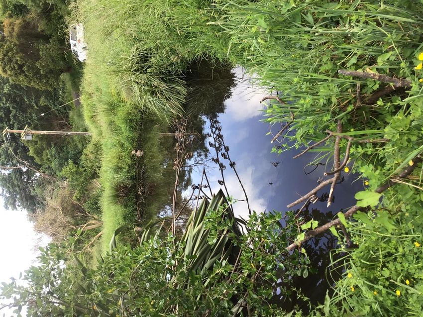
Cover photograph: Natural wetland (pond) habitat within the Trackside area (as identified by Plot A community) © BML 2019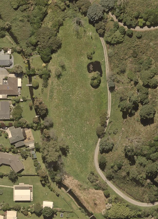
Contents
Executive Summary.................................................................................................................................................... 5

         Introduction ...................................................................................................................................................... 8
   1.1       Scope ............................................................................................................................................................. 8
   1.2       Site Location and Project Description ............................................................................................................ 8

         Methodology..................................................................................................................................................... 9
   2.1       Desktop Investigation ..................................................................................................................................... 9
   2.2    Field Investigation .......................................................................................................................................... 9
     2.2.1     Survey Limitations ................................................................................................................................. 12
   2.3    Assessing Ecological Significance ............................................................................................................... 12
     2.3.1    Wetland habitats - determination and regulation .................................................................................. 12
   2.4    Evaluation of the Level of Ecological Effects ............................................................................................... 13
     2.4.1    Assigning Ecological Value ................................................................................................................... 13
     2.4.2    Assessing Magnitude of Effect.............................................................................................................. 15
     2.4.3    Assessing Level of Impact .................................................................................................................... 16
   2.5       Proposed Natural Resources Plan GWRC .................................................................................................. 16

         Results – Existing Environment ................................................................................................................... 17
   3.1       Site Context .................................................................................................................................................. 17
   3.2    Wetland habitats........................................................................................................................................... 17
     3.2.1    Wetland Descriptions ............................................................................................................................ 17
       3.2.1.1 Trackside ........................................................................................................................................... 19
       3.2.1.2 Roadside ........................................................................................................................................... 26
       3.2.1.3 Carex Wetland ................................................................................................................................... 30
       3.2.1.4 Shed .................................................................................................................................................. 31
     3.2.2    Wetland survey summary ..................................................................................................................... 31
       3.2.2.1 Major community surveys.................................................................................................................. 31
       3.2.2.2 Minor community surveys.................................................................................................................. 33
     3.2.3    Wetland verification and interpretation ................................................................................................. 34
       3.2.3.1 Ecological status ............................................................................................................................... 34
       3.2.3.2 Regulatory status .............................................................................................................................. 35
     3.2.4    Overall summary of results ................................................................................................................... 35

         Ecological Value ............................................................................................................................................ 36

         Assessment of Ecological Effects ............................................................................................................... 37
   5.1    Wetland Environment ................................................................................................................................... 37
     5.1.1    Retention basins within Trackside and Roadside wetland areas ......................................................... 37
       South-west basin ............................................................................................................................................. 39
       North-east basin............................................................................................................................................... 40
     5.1.2    Carex wetland catchment reduction ..................................................................................................... 40
     5.1.3    Sediment Discharge Events.................................................................................................................. 40
     5.1.4    Contaminant Run-Off ............................................................................................................................ 41
   5.2       Impacts on Nearby Ecosites and Wetlands ................................................................................................. 41

         Summary of the Level of Ecological Effects ............................................................................................... 41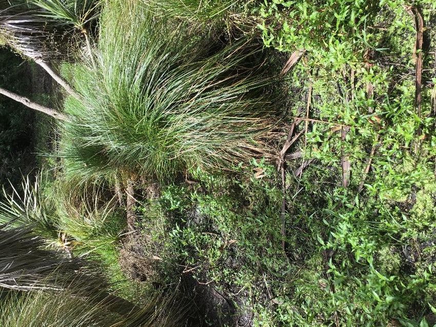
Effects Management Hierarchy – Recommendations ............................................................................... 42
7.1    Avoid, Minimise and Remedy: ..................................................................................................................... 43
  7.1.1    Natural Wetland Environment - Avoidance .......................................................................................... 43
  7.1.2    Natural Wetland Environment - Minimise ............................................................................................. 43
  7.1.3    Natural Wetland Environment - Remedy ............................................................................................. 44
    7.1.3.1 Trackside and Roadside wetlands.................................................................................................... 44
    7.1.3.2 Carex wetland ................................................................................................................................... 44
7.2      Offset: .......................................................................................................................................................... 44
7.3      Biodiversity Gains ........................................................................................................................................ 44

      Conclusion ..................................................................................................................................................... 46

      References ..................................................................................................................................................... 46

      Site Photos .................................................................................................................................................... 48

      Appendices .................................................................................................................................................... 53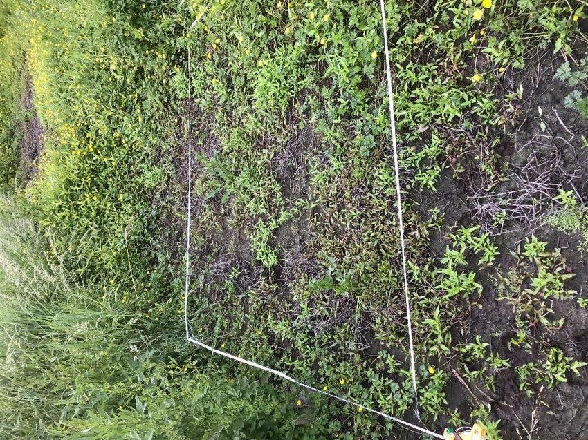
Executive Summary

This assessment considers the potential ecological effects on wetlands of the proposed
Summerset Retirement Village in Waikanae, Kapiti.
After an iterative design process for stormwater management on the site, the proposed
stormwater management system has been designed such that any direct physical works to the
existing natural wetlands have been avoided. Monitoring is recommended along with remedial
actions to ensure this is the case. The retention of the existing wetlands, the wetland-planted
stormwater basins, and the creation of a new large native representative wetland feature
(designed as an ecological gain), is a considerable increase in wetland habitat area and
representativeness and quality on the property. The proposed development has a considerable
net benefit for wetlands (i.e. the retention of the 488m2 and the addition of 700m2).
Project Description
Summerset Villages (Waikanae) Limited owns a 25.5 ha property at 32 Park Avenue, Waikanae
(the project site or site) and is proposing to construct a Summerset Retirement Village on
approximately 8 ha of the site, as well as associated amenities and infrastructure, the
development includes the creation of stormwater retention basins that are in the proximity of
existing wetlands.
Method of assessment

    •   A range of desktop and field investigations (including the NPS-FM recommended
        Clarkson 2018 Wetland delineation protocols) were used to describe the wetland
        habitats present within the project site.

    •   Once described, the significance of each identified wetland habitat was determined
        against the Proposed Natural Resources Plan (‘PNRP’) [appeals version], and
        ecological values were described based on the EIANZ guidelines. An iterative design
        process was undertaken to manage the potential effects. This was followed by an
        assessment of ecological effects using the EIANZ (2018) guidelines.

    •   The assessment followed the PNRP Schedule G1 in order to ensure the mitigation
        hierarchy was adhered to, i.e.: measures to avoid, minimise, remedy and mitigate
        adverse effects are described.
Existing Environment
The proposed Summerset Village project site is within the Foxton Ecological District and is
zoned ‘Ngarara’ under both the operative and proposed Kapiti Coast District Plans which
provides for residential development. The site also includes three natural wetland habitats
(Trackside, Roadside and Carex wetlands). The project site does not contain any KCDC
Ecological Sites (Schedule 3.1 of the District Plan; however, a few are present in the wider
area) or any wetlands with open space wetland buffers as shown in the Ngarara Structure Plan.
The wetland habitats present do not contain Rare or Threatened Species (Schedule 3.3) or Key
Indigenous Tree Species (3.2A).

                          Boffa Miskell Ltd | Summerset Waikanae | Wetland Ecological Impact Assessment | 31 March 2021   5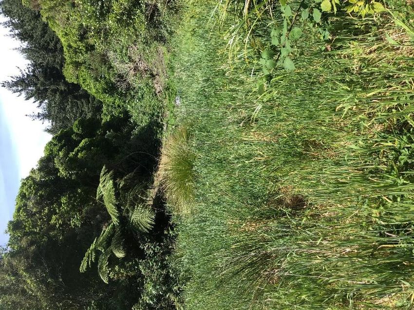
Determination of Significance
    As defined in the PNRP), the three natural wetlands are automatically considered to be
    significant and no additional assessment is required.
    Assessment of Value
    The wetland habitats are, irrespective of being significant by the policy, of Low Ecological Value
    due to the level of modification, dominance of exotic common species, minimal wetland
    functions and lack of integrity and representativeness.
    Assessment of Effects
    Direct effects to three of the natural wetlands have been avoided and hydrological effects
    potentially affecting the Carex wetland have been mitigated and minimised and a remedial
    strategy recommended should related adverse effects be monitored to occur.
    Effects are expected to be low to none for the Carex wetland, with any minimal effects able to
    be remedied through the proposed conditions of consent.
    Potential sediment discharge, contaminant run-off/discharge, and impacts on nearby wetlands
    all have very low or negligible effects (depending on the size of any potential sediment
    discharge).
    Recommendations

    •    Avoid damaging the wetland habitats.

    •    Minimise hydrological changes to the wetlands.

    •    Avoid introducing exotic weed species into the area.

    •    Minimise the effect that reduction of the catchment size of the Carex wetland will have on
         the wetland through felling the slope of pines to reduce the water transpiration take of those
         trees.

    •    Monitor the Carex wetland after works to establish if weed invasion is occurring or whether
         the wetland extent is shrinking. Remediate these effects through weed control and by
         revegetation with better suited native wetland plants if necessary.

    •    To minimise effects from potential discharge events, industry standard erosion and
         sediment controls should be in place and maintained throughout the construction of the
         Village.

    •    Monitor the Trackside and Roadside wetlands through construction and post construction to
         ensure the physical works remain outside of the wetlands and that the hydrology is as
         predicted. Where plant changes are measured to be occurring because of a hydrology
         change (wetter or drier) establish better suited native wetland species.
    Indigenous Biodiversity gains
    The creation of a new wetland (approximately 642 m2) adjacent to the existing Trackside
    wetland, volunteered by the applicant, coupled with the wetland habitat the stormwater basins
    will provide, is a significant wetland gain.
    Overall, post development, we anticipate the site/property to contain the following wetland
    habitats/features:

6   Boffa Miskell Ltd | Summerset Waikanae | Wetland Ecological Impact Assessment | 31 March 2021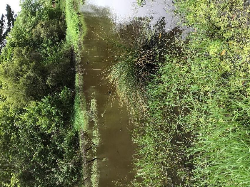
i.      Natural wetlands
            a. Trackside area (existing) - 203 m²
            b. Roadside area (existing) - 99 m²
            c.   Carex wetland (existing) - 1,206 m²
            d. Enhancement wetland (created) - 642 m² (including approximately 303 m²
               perennial wetland and 336 m² ephemeral wetland) + 580 m² of indigenous
               riparian vegetation to help protect and enhance the created wetland habitats
    ii.     Stormwater basins
            a. Southwest stormwater basin that will be planted and provide habitat and
               opportunities for wetland flora and fauna - 1,280 m²
            b. Northeast stormwater basin that will be planted and provide habitat and
               opportunities for wetland flora and fauna - 560 m².
The current approximately 1,508 m² of wetland habitat (including improvements made to
existing wetlands) will increase to approximately 3,990 m² post development (i.e. a 165% gain
in area alone).

                           Boffa Miskell Ltd | Summerset Waikanae | Wetland Ecological Impact Assessment | 31 March 2021   7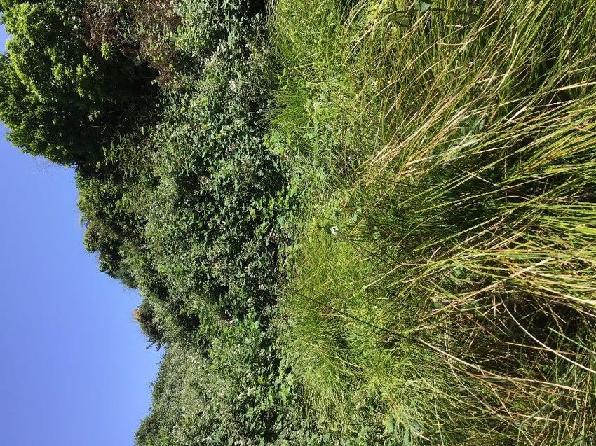
Introduction

    1.1         Scope
    Summerset Villages (Waikanae) Limited engaged Boffa Miskell to prepare a Wetland Ecological
    Impact Assessment (WEIA) as part of a new application under the Covid-19 Recovery (Fast
    Track Consenting) Act. This follows on, and benefits from, stakeholder consultation in
    anticipation of resource consent application, including with Greater Wellington Regional Council,
    to construct and operate Summerset’s Comprehensive Care Retirement Village in Waikanae.
    The objectives of this wetland ecological assessment are to:

         •    Describe the wetland habitats and features potentially affected by the development;

         •    Determine the significance (in terms of section 6(c) of the RMA) and ecological value of
              the wetland habitats and features;

         •    Describe the process and outcome of determining and managing the potential adverse
              effects through the design process, to the application process, and identify any adverse
              effects that remain after the process of avoidance and minimisation;

         •    Follow the PNRP Schedule G1 mitigation hierarchy (which is synonymous with the
              NPS-FM’s effects management hierarchy) processes to manage effects beyond
              avoidance; and

         •    To address residual ecological effects, if any, after the mitigation hierarchy has been
              applied, through ecological offsetting.
    This assessment will outline:

         •    A description of the project and site location (Section 1.2).

         •    A description of the assessment methodology (Section 2.0)

         •    The assessment results, including the determination of ecological significance (Section
              3.0).

         •    An assessment of the ecological values of the wetland habitats (Sections 4.0).

         •    An assessment of the ecological effects (Sections 5.0 and 6.0).

         •    The recommendations to avoid, minimise, remedy and mitigate potential adverse
              ecological effects (Section 7.0),

         •    The conclusions on effects and recommendations (Section 8.0).

    1.2         Site Location and Project Description
    The proposed Summerset Village is located at 32 Park Avenue, Waikanae, on the eastern side
    of the Mackays to Peka Peka Expressway (Appendix 1).
    The total land area of the site is 25.5 ha. It is proposed that an approximately 8 ha retirement
    village platform will be constructed in the middle of the site. The remaining 17.5 ha of balance
    land will be partly used for associated amenities and infrastructure (including stormwater basins
    within the proximity of existing natural wetlands). Significant cut and fill earthworks

8   Boffa Miskell Ltd | Summerset Waikanae | Wetland Ecological Impact Assessment | 31 March 2021
(approximately 300,000 m3) are required to create the village platform and for site access. A
further 4-6 ha of the undeveloped part of the site will be required for cut and fill batters and a
site-specific stormwater management system. The stormwater system will intercept and collect
runoff from the site and convey it, together with road runoff, to two attenuation/retention basins
via pipes and/or swales as outlined in the Civil Infrastructure Report. Stormwater will be
discharged to the Kapiti Expressway stormwater system and Waimeha Stream (up to pre-
development flows).

               Methodology

This assessment follows the EIANZ (2018) EIA methodological process and includes aspects of
the PNRP policies and schedules and the NPS-FM (2020) in relation to wetlands.
To assess the potential effects of the proposed Village on indigenous biota (plants and animals)
and features (habitats) within the project site, information was gathered from relevant published
and unpublished sources through a desktop investigation and field surveys as described below.

2.1            Desktop Investigation
The desktop investigation included a review of scientific literature (published and unpublished),
the District Plan and associated Ecological Site information, and relevant websites.
Ecological databases were also accessed. These included: the LENZ Threatened Environments
Classification (Landcare Research Ltd, 2012), the NIWA-administered New Zealand Freshwater
Fish Database (NZFFD; (National Institute of Water and Atmospheric Research, n.d.)1.
GIS, current aerials and site investigations were used to map the current extent of wetland
habitat. GIS was used to check that the project site does not lie within the open space wetland
buffers of specific wetlands identified within the Ngarara Structure Plan.

2.2            Field Investigation
Field investigations comprised:

        •    Areas of potential wetland habitats were initially identified using topographic maps and
             pre-existing knowledge of the site and surrounds. In total, four potential wetland sites
             were identified which may be affected by the proposed Village (Figure 1), including the
             Trackside, Roadside, Carex, and Shed areas.

        •    An initial reconnaissance visit to the project site was then conducted by Boffa Miskell
             ecologists on 11 October 2019 to view the site and confirm the locations of potential
             wetland habitats.

1
    The NZFFD was accessed on 26 September 2019. The database website is https://nzffdms.niwa.co.nz

                                      Boffa Miskell Ltd | Summerset Waikanae | Wetland Ecological Impact Assessment | 31 March 2021   9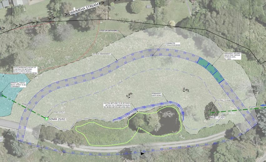
•     Two wetland surveys were then conducted on 06 December 2019 and 25 September
                   2020 by suitably qualified Boffa Miskell ecologists. The surveys conducted are
                   described in further detail below.

     The first survey on 6 December 2019 was to better delineate the potential wetland areas and
     describe their major vegetation community structure. To assist, at least one 2 m x 2 m plot was
     established in each notably different vegetation community within each potential wetland and
     corresponding plant lists were compiled in accordance with the Plot Sampling Procedure
     described in A Vegetation Tool for Wetland Delineation (Clarkson, 2013). This approach is
     directed by the NPS-FM. This process involved identifying all species within the 2 m x 2 m plots
     and estimating their percent cover (based on above-ground live biomass).
     The second survey (25 September 2020) occurred following discussions with Greater
     Wellington Regional Council representatives. As a result of those discussions, the second
     survey included minor community changes in the plot analyses for the Trackside and Roadside
     potential wetland areas due to uncertainty around the wetland boundaries and extents. The
     carex wetland area was not included in the additional surveys as it was agreed the entire area
     provided wetland habitat. This approach diverges from the Clarkson (2013) method (and
     therefore the approach under the NPS-FM) which recommends surveying the major
     communities but was requested by Greater Wellington Regional Council. This requested
     approach limits the ability to consider landscape, context, and topography, so caution was
     applied when using these additional data to alter the extent of wetland habitat originally
     delineated. As such, the minor plot data were required to provide a prevalence score below the
     ambiguous range (
i. Prevalence Test
First, we undertake a prevalence test to determine the vegetation species and their affinity for
water. Vegetation species are allocated to one of the prescribed categories described by
Clarkson (2013) and presented in Table 1.
Table 1: Wetland affinity categories that vegetation species are allocated to based on their affinity and likely occurrence in wetlands.
Affinity category Description Estimated
probability of
occurrence
in wetlands
OBL - Obligate wetland Almost always is a hydrophyte, rarely in uplands >99%
FACW - Facultative wetland Usually is a hydrophyte but occasionally found in 67-99%
uplands
FAC - Facultative Commonly occurs as either a hydrophyte or non- 34-66%
hydrophyte
FACU - Facultative upland Occasionally is a hydrophyte but usually occurs in 1-33%
uplands
UPL - Obligate upland Rarely is a hydrophyte, almost always in uplandsThis assessment included digging at least two holes in the ambiguous area to a minimum of
500 mm to determine if there were indicators of hydric soils (mottles, gley soils, peat,) within the
profile (but below the topsoil). Each soil layer was smelt for signs of “rotten eggs” which can
indicate hydric soils, and the topsoil layer was inspected for any black manganese concretions
in the topsoil.
2.2.1 Survey Limitations
The wetland vegetation plot surveys were limited to potential wetland habitats and their
surrounds identified from topographical maps and/or during the initial site walkover. They did
not include any other areas.
2.3 Assessing Ecological Significance
2.3.1 Wetland habitats - determination and regulation
Our professional view is that the PNRP and NPS-FM are fundamentally flawed. The PNRP
recognises exotic dominated heavily modified wetlands as "significant" irrespective of their low
ecological value or lack of indigenous biodiversity.
The PNRP definition of “natural wetland” includes the following add-on:
“Note that, because of the rarity of wetlands in the Wellington Region, all natural wetlands
will meet the representative and rarity criteria listed in Policy 23 of the Regional Policy
Statement 2013 and therefore meet the definition of significant natural wetland.”
The PNRP defines a “natural wetland” as:
"a permanently or intermittently wet area, shallow water and land water margin that
supports a natural ecosystem of plants and animals that are adapted to wet conditions,
including in the beds of lakes and rivers.”
The meaning of “natural” becomes crucial and is not defined in the PNRP. However, under the
“natural processes” and “natural lake” definitions the suggestion is that the feature is formed by
non-human processes that are the result of the surrounding topography, hydrology, winds, and
other “natural” processes. In essence, it has, or could have, formed and persisted in the
absence of human modification/activity. Irrespective of the lack of a definition of “natural”, the
PNRP acknowledges that natural wetlands do not include damp gully heads or wetted pasture,
or pasture with patches of rushes (there are other exceptions but those relate to the source of
the water).
Policy 23 of the RPS is used to identify significant indigenous ecosystems and habitats as
recognised by Section 6(c) of the RMA. Under this policy, any wetland in the Wellington Region
is considered significant if it is indigenous, and meets specifications in at least one of its five
categories (representativeness, rarity, diversity, ecological context, and tangata whenua
values).
The current PNRP however, states that all features found to be a “natural wetland” are by
default significant (because they would all pass the rarity ‘test’ in Policy 23 of the RPS).
However, Policy 23 is directed to indigenous species and features. It is indigenous dominated
wetlands that are rare and underrepresented. Exotic induced wetlands are not rare.
12 Boffa Miskell Ltd | Summerset Waikanae | Wetland Ecological Impact Assessment | 31 March 20212.4 Evaluation of the Level of Ecological Effects
Acknowledging Policy 40 of the PNRP (the requirement to protect and restore natural wetlands)
and Policy 6 of the NPS-FM, we must still undergo an assessment of value of the feature and
the magnitude of the potential effect to establish the potential level of effect prior to enacting the
mitigation hierarchy. The methodology for assessing the level of the ecological effects on
wetlands associated with the proposed Village follows that in the EIANZ Ecological Impact
Assessment Guidelines (Roper-Lindsay et al., 2018). This is considered to represent the best
practise approach in New Zealand. In summary, this method requires:
• An assessment of the values of the wetland communities, habitats, and ecosystems (Table
2, Table 3, and Table 4);
• An assessment of the magnitude of the effects on these values (based on criteria listed in
Table 5); and
• The application of a matrix (Table 6) which determines the level of effect based on the
ecological value of the site or species assessed and the magnitude of effect.
2.4.1 Assigning Ecological Value
Matters and attributes considered when assigning ecological value to wetland habitats are not
specifically described in the EIANZ guidelines. The determination of a wetland feature as
“natural” and therefore automatically significant (see policy 40), does not also automatically
make the wetland feature of high value. A process to examine the condition, species
assemblage, its representativeness, its integrity, its indigenous / exotic balance etc must still be
undertaken. We have assigned value by considering and utilising appropriate aspects of both
the terrestrial Table 2) and freshwater (Table 3) criteria (including representativeness,
rarity/distinctiveness, diversity and pattern, and ecological context). Each of the four criteria are
subjectively scored “High”, “Moderate”, “Low”, or “Very Low” based on the assessor’s
experience and knowledge of the site. The four scores are then combined to provide a single
score for each wetland habitats which ranges from “Very High” to “Negligible” (Table 4).
Table 2. Attributes to consider when assigning ecological value or importance to a site or area of vegetation/habitat/community (Roper-
Lindsay et al., 2018).
Matter: Attributes to be Considered:
Representativeness Criteria for representative vegetation and habitats:
• Typical structure and composition
• Indigenous species dominate
• Expected species and tiers are present
• Thresholds may need to be lowered where all examples of a type are
strongly modified
Criteria for representative species and species assemblages:
• Species assemblages that are typical of the habitat
• Indigenous species that occur in most of the guilds expected for the
habitat type
Rarity/Distinctiveness Criteria for rare/distinctive vegetation and habitats:
• Naturally uncommon, or induced scarcity
• Amount of habitat or vegetation remaining
• Distinctive ecological features
Boffa Miskell Ltd | Summerset Waikanae | Wetland Ecological Impact Assessment | 31 March 2021 13Matter: Attributes to be Considered:
• National priority for protection
Criteria for rare/distinctive species or species assemblages:
• Habitat supporting nationally Threatened or At Risk species, or locally
uncommon species
• Regional or national distribution limits of species or communities
• Unusual species or assemblages
• Endemism
Diversity and Pattern • Level of natural diversity, abundance and distribution
• Biodiversity reflecting underlying diversity
• Biogeographical considerations – pattern, complexity
• Temporal considerations, considerations of lifecycles, daily or
seasonal cycles of habitat availability and utilisation
Ecological Context • Site history, and local environmental conditions which have influenced
the development of habitats and communities
• The essential characteristics that determine an ecosystem’s integrity,
form, functioning, and resilience (from “intrinsic value” as defined in
RMA)
• Size, shape and buffering
• Condition and sensitivity to change
• Contribution of the site to ecological networks, linkages, pathways and
the protection and exchange of genetic material
• Species role in ecosystem functioning – high level, key species
identification, habitat as proxy
Table 3: Matters that may be considered when assigning ecological value to a freshwater site or area (Roper-Lindsay et al., 2018).
Matter: Attributes to be Considered:
Representativeness • Extent to which site/catchment is typical or characteristic
• Stream order
• Permanent, intermittent or ephemeral waterway
• Catchment size
• Standing water characteristics
Rarity/Distinctiveness • Supporting nationally or locally Threatened, At Risk or uncommon
species
• National distribution limits
• Endemism
• Distinctive ecological features
• Type of lake/pond/wetland/spring
Diversity and Pattern • Level of natural diversity
• Diversity metrics
• Complexity of community
• Biogeographical considerations - pattern, complexity, size, shape
Ecological Context • Stream order
• Instream habitat
• Riparian habitat
• Local environmental conditions and influences, site history and
development
• Intactness, health and resilience of populations and communities
• Contribution to ecological networks, linkages, pathways
• Role in ecosystem functioning – high level, proxies
14 Boffa Miskell Ltd | Summerset Waikanae | Wetland Ecological Impact Assessment | 31 March 2021Matter: Attributes to be Considered:
Ecological Integrity3 • Nativeness – the degree to which an ecosystem’s structural composition
is dominated by the indigenous biota characteristics of the particular
region
• Pristineness – relates to a wide array of structural, functional and
physico-chemical elements (including connectivity), but is not
necessarily dependent on indigenous biota constituting structural and
functional elements
• Diversity – richness (the number of taxa) and evenness (the distribution
of individuals amongst taxa); link to a possible reference condition; the
use abundance weighting; and geographical scale
• Resilience (or adaptability) – quantifying the probability of maintaining an
ecosystem’s structural and functional characteristics under varying
degrees of human pressure or stressors such as climate change.
Table 4: Scoring for sites or areas combining values for the four matters in Table 2 and Table 3 (from Roper-Lindsay et al., 2018)
Matter: Attributes to be Considered:
Very High • Area rates High for 3 or all of the four assessment matters listed in Table 2.
• Likely to be nationally important and recognised as such.
High • Area rates High for 2 of the assessment matters, Moderate and Low for the
remainder, or
• Area rates High for 1 of the assessment maters, Moderate for the remainder.
• Likely to be regionally important and recognised as such.
Moderate • Area rates High for one matter, Moderate and Low for the remainder, or
• Area rates Moderate for 2 or more assessment matters Low or Very Low for the
remainder
• Likely to be important at the level of the Ecological District.
Low • Area rates Low or Very Low for majority of assessment matters and Moderate for
one.
• Limited ecological value other than as local habitat for tolerant native species.
Negligible • Area rates Very Low for 3 matters and Moderate, Low or Very Low for remainder
2.4.2 Assessing Magnitude of Effect
Once the value of the ecosystem components has been determined, the magnitude of the effect
is assessed. Magnitude of effect is a measure of the extent or scale of the impact, its duration,
and the degree of change that it will cause. A typical scale of magnitude ranges from Very High
to Negligible as outlined in Table 5.
Table 5. Criteria for describing magnitude of effect (Roper-Lindsay et al., 2018).
Magnitude Description:
of Effect:
Very High Total loss of, or very major alteration to, key elements/ features of the baseline
conditions, such that the post development character, composition and/or attributes will
be fundamentally changed and may be lost from the site altogether; AND/OR loss of a
very high proportion of the known population or range of the element/feature.
3
In addition to the measure prescribed in Table 2, an additional matter is considered when assigning ecological value to freshwater
environments as described in (Roper-Lindsay et al., 2018). Ecological Integrity is considered as a way of integrating structural and
functional components of freshwater systems into the ecological values matrix. The ‘nativeness’, ‘pristineness’, diversity’, and ‘resilience’
are all considered when determining ecological integrity.
Boffa Miskell Ltd | Summerset Waikanae | Wetland Ecological Impact Assessment | 31 March 2021 15High Major loss or major alteration to key elements/ features of the baseline conditions such
that post development character, composition and/or attributes will be fundamentally
changed; AND/OR loss of a high proportion of the known population or range of the
element/feature.
Moderate Loss or alteration to one or more key elements/features of the baseline conditions such
that post development character, composition and/or attributes of the existing baseline
will be partially changed; AND/OR loss of a moderate proportion of the known
population or range of the element/feature
Low Minor shift away from baseline conditions. Change arising from the loss/alteration will
be discernible but underlying character, composition and/or attributes of existing
baseline condition will be similar to predevelopment circumstances/patterns; AND/OR
having a minor effect on the known population or range of the element/feature.
Negligible Very slight change from baseline condition. Change barely distinguishable,
approximating to the “no change” situation; AND/OR having negligible effect on the
known population or range of the element/feature.
2.4.3 Assessing Level of Impact
The overall level of the effect is determined by applying the following matrix (Table 6), which
combines the ecological value (Table 4) and the magnitude of the effect (Table 5).
Table 6. Criteria for describing the level of effect (Roper-Lindsay et al., 2018).
ECOLOGICAL VALUE
Very High High Moderate Low Negligible
Very High Very High Very High High Moderate Low
High Very High Very High Moderate Low Very Low
MAGNITUDE
Moderate High High Moderate Low Very Low
Low Moderate Low Low Very Low Very Low
Negligible Low Very Low Very Low Very Low Very Low
Positive Net Gain Net Gain Net Gain Net Gain Net Gain
2.5 Proposed Natural Resources Plan GWRC
When effects are assessed, the GWRC PNRP, through Schedule G1, directs an applicant to
manage those adverse effects by, in the first instance, following the mitigation hierarchy (i.e.
avoid, minimise, and remedy), similarly referred to as the effects management hierarchy in the
NPS-FM. Where there remain adverse effects (i.e. the effects are not zero, there is a residual
effect), then Schedule G2 should be consulted and used (principals to be applied when
considering an offset). We have followed this process.
16 Boffa Miskell Ltd | Summerset Waikanae | Wetland Ecological Impact Assessment | 31 March 2021Results – Existing Environment
This section combines the results of the desktop and field investigations to describe the existing
environment within the proposed project site.
3.1 Site Context
The proposed project site is located in the Kāpiti Coast District within the Wellington Region.
Ecologically, the site is on the boundary of the Foxton Ecological District (ED 31.02). The
Foxton ED is described as containing the most extensive sand-dune system in the country.
Sand-dunes along with dune lakes, wetlands and swamps were a major feature of the Foxton
ED, however today only fragments of native vegetation and wetlands remain (McEwen, 1987).
3.2 Wetland habitats
3.2.1 Wetland Descriptions
The following provides descriptions of each potential wetland area (Trackside, Roadside, Carex,
and Shed) as well as descriptions of the subsequent surveyed vegetation communities.
Descriptions of the major communities (Figure 1) are provided for all areas, and then
descriptions of the minor (or sub) communities are provided for subsets of the Trackside (Plot B;
Figure 2) and Roadside (Plot E; Figure 3) areas. As described in the methods above, only minor
communities were included as wetlands where their prevalence scores were between 1 and 2.5
(i.e. they did not return a further ambiguous score) as well as satisfying the other considerations
(dominance test, pasture test).
Boffa Miskell Ltd | Summerset Waikanae | Wetland Ecological Impact Assessment | 31 March 2021 17File Ref: BM19539_Summerset.aprx / BM19539_01_WetlandHabitatOverview_A3L
Mi
y1
rek
ig hwa
te H
S
Sta
tre
et
Roadside
Ar
aH
ia
ah
ere
wak
a
ke
K
A ra
Te
y1
h wa
Hig
te
Sta
Carex Wetland
y 1
h wa Shed
H ig
e
at
St
1
ay
hw
ig
H
ate
St
Te Mo
ana R
Trackside
oad
°
This plan has been prepared by Boffa Miskell Limited on 0 40 m
Site Boundary SUMMERSET WAIKANAE - ECOLOGY
DRAFT
LEGEND
the specific instructions of our Client. It is solely for our
Wetland Habitat Overview
Client's use in accordance with the agreed scope of work.
Any use or reliance by a third party is at that party's own 1:2,000 @ A3 Major communities
risk. Where information has been supplied by the Client Figure 1
or obtained from other external sources, it has been
assumed that it is accurate. No liability or responsibility is Data Sources: Sourced from the LINZ Data Service and licensed for Wetland Date: 25 March 2021 | Revision: 1
accepted by Boffa Miskell Limited for any errors or re-use under the Creative Commons Attribution 4.0 New Zealand Plan prepared by Boffa Miskell Limited
omissions to the extent that they arise from inaccurate licence , BML Non-wetland
www.boffamiskell.co.nz information provided by the Client or any external source. Projection: NZGD 2000 Wanganui Circuit Project Manager: karin.sievwright@boffamiskell.co.nz | Drawn: KMa | Checked: JGa
Raised ground3.2.1.1 Trackside
Trackside major community surveys
This area runs alongside the Waimeha tributary and includes a small pond depression.
Waimeha is spring-fed and subsequently is not a significant flood area. The appearance of
three distinct plant community groups meant three plots were surveyed (Table 7). The riparian
margin of Waimeha Stream is not considered here but was dominated by exotic trees and
shrubs (e.g. willows, poplars, arum lily, etc). This potential wetland area resides within what
appears to be an old braid of Waikanae River and is at the toe of an old terrace (which can be
damp areas due to groundwater resurfacing).
Table 7: Plot data for the major community types in the Trackside area, including vegetation lists and their contributing cover, and the
summary wetland indication indices.
Plot Plot notes Affinity Species and % cover Total affinity
classes class cover
A This plot recorded vegetation most OBL Callitriche petriei - 2% 2%
representative of a natural wetland,
not including the pond area itself. FACW Persicaria maculosa - 26% 27%
At the time of survey, there was no
Persicaria hydropiper - 1%
surface water in this area; however,
the soil was damp with large areas FAC Ranunculus repens - 10% 10%
of bare earth (60% of the plot
area). FACU None present 0%
UPL None present 0%
Prevalence score: 2.225
Dominance test: >50% of dominant species are FAC, FACW, and/or OBL
Exotic proportion: 95%
Pasture cover: 1%
B This plot represents the rush and OBL None present 0%
grass section of the Trackside area
(which includes the northern FACW Juncus edgariae - 25% 26%
approx. 35% of the area). The
Persicaria hydropiper - 1%
dominant cover was not of wetland
species and there were were no FAC Holcus lanatus - 10% 19%
wetland obligate species.
Lolium arundinaceum subsp.
arundinaceum - 5%
Ranunculus repens - 4%
FACU Lolium perenne - 25% 35%
Plantago lanceolata - 10%
UPL Cynosurus cristatus - 20% 20%
Prevalence score: 3.49
Dominance test:Plot Plot notes Affinity Species and % cover Total affinity
classes class cover
C This plot represents the grassland OBL None present 0%
section of the Trackside area which
comprised entirely exotic FACW None present 0%
vegetation species.
FAC Holcus lanatus - 40% 45%
Ranunculus repens - 5%
FACU Lolium perenne - 20% 30%
Dactylis glomerata - 10%
UPL Bromus willdenowii - 25% 25%
Prevalence score: 3.8
Dominance test: 2.5 prevalence score), and none have vegetation
indicative of a permanently wet soil (i.e. no Obligate wetland species identified). Exotic grasses
and buttercup are the dominant feature throughout the entire area, with occasional patches of
Carex lessoniana (native) and Juncus effusus (exotic) spread throughout. C. lessoniana and
very low occurrences of Cyperus ustulatus were the only native species recorded in the
sampled areas.
Table 8: Plot data for the minor community types found within the Plot B area of the originally surveyed major community types in the
Trackside area, including vegetation lists and their contributing cover, and the summary wetland indication indices.
Plot Plot notes Affinity Species and % cover Total affinity
classes class cover
1 The vegetation community in the OBL None present 0%
Plot 1 area is dominated by
grasses and creeping buttercup. FACW Carex lessoniana - 10% 12%
The area is small, and blackberry
Juncus effuses - 2%
(which made up 4% of the plot) is
beginning to extend from the trees FAC Ranunculus repens - 35% 93%
at the northern margin. No surface
water was present at the time of Lolium arundinaceum subsp.
survey and soil underfoot was not arundinaceum - 30%
noticeably soft.
Holcus lanatus - 25%
20 Boffa Miskell Ltd | Summerset Waikanae | Wetland Ecological Impact Assessment | 31 March 2021Plot Plot notes Affinity Species and % cover Total affinity
classes class cover
Lotus pendunculatus - 2%
Rumex crispus - 1%
FACU Rubus fruticosus - 4% 4%
UPL None present 0%
Prevalence score: 3.19
Dominance test: >50% of dominant species are FAC, FACW, and/or OBL
Exotic proportion: 90%
Pasture cover: 57%
2 Plot 2 was placed in an area OBL None present 0%
distinguished from Plot 1 by a slight
increase in Juncus, and the FACW Juncus effusus - 7% 9%
replacement of pasture grasses by
Carex lessoniana - 2%
creeping buttercup. As with Plot 1,
soil did not feel soggy underfoot. FAC Ranunculus repens - 70% 90%
Holcus lanatus - 15%
Lotus pendunculatus - 5%
FACU Platago lanceolata - 1% 2%
Convolvulus sp4. - 1%
UPL None present 0%
Prevalence score: 2.96
Dominance test: >50% of dominant species are FAC, FACW, and/or OBL
Exotic proportion: 98%
Pasture cover: 21%
3 This area was a small subset within OBL None present
the Plot 2 community which was
characterised by its increased C. FACW Carex lessoniana - 25% 35%
lessoniana coverage. Other than
Juncus effusus - 8%
this, the community did not differ
markedly, if at all, from the Cyperus ustulatus - 2%
surrounding community.
FAC Ranunculus repens - 35% 70%
Holcus lanatus - 30%
Lotus pendunculatus - 5%
FACU Plantago lanceolata - 1% 2%
Rubus fruticosus - 1%
UPL None present 0%
Prevalence score: 2.88
4
Note the convolvulus sp. was not flowering at the time of survey. Furthermore, convolvulus species are not included in the list of plants
with corresponding affinity scores in (Clarkson, 2013), so we have conservatively considered it a facultative upland species due to
knowledge of its preferred habitat/growing conditions.
Boffa Miskell Ltd | Summerset Waikanae | Wetland Ecological Impact Assessment | 31 March 2021 21Plot Plot notes Affinity Species and % cover Total affinity
classes class cover
Dominance test: >50% of dominant species are FAC, FACW, and/or OBL
Exotic proportion: 73%
Pasture cover: 36%
4 This community adjoins the Plot 2 OBL None present 0%
community and was distinguished
by its reduction in J. effusus (3%), FACW Juncus effusus - 3% 4%
C. lessoniana (1%), and increases
Carex lessoniana - 1%
in blackberry (4%) and Yorkshire
fog (40%). FAC Ranunculus repens - 50% 92%
Holcus lanatus - 40%
Zantedeschia aethiopica - 2%
FACU Rubus fruticosus - 4% 5%
Convolvulus sp. - 1%
UPL None present 0%
Prevalence score: 3.04
Dominance test: >50% of dominant species are FAC, FACW, and/or OBL
Exotic proportion: 99%
Pasture cover: 40%
5 This community was located along OBL None present 0%
the base of a dry bund bordering
the pond and differed from the Plot FACW Carex lessoniana - 25% 45%
2 and Plot 4 communities by an
Juncus effusus - 20%
increase in C. lessoniana and a
reduction in creeping buttercup. FAC Holcus lanatus - 26% 54%
Ranunculus repens - 25%
Lolium arundinaceum subsp.
arundinaceum - 3%
FACU Anthoxanthum odoratum - 1% 1%
UPL None present 0%
Prevalence score: 2.56
Dominance test: >50% of dominant species are FAC, FACW, and/or OBL
Exotic proportion: 75%
Pasture cover: 30%
6 Plot 6 was dominated by pasture OBL None present 0%
and contained the most Facultative
Upland species of all the plots. FACW Juncus effusus - 20% 20%
FAC Lolium arundinaceum subsp. 33%
arundinaceum - 28%
Ranunculus repens - 3%
Holcus lanatus - 2%
22 Boffa Miskell Ltd | Summerset Waikanae | Wetland Ecological Impact Assessment | 31 March 2021Plot Plot notes Affinity Species and % cover Total affinity
classes class cover
FACU Anthoxanthum odoratum - 45% 49%
Plantago lanceolata - 2%
Convulvulus sp. - 1%
Rubus fruticosus - 1%
UPL None present 0%
Prevalence score: 3.35
Dominance test: >50% of dominant species are FAC, FACW, and/or OBL
Exotic proportion: 100%
Pasture cover: 77%
7 The Plot 7 community was based in OBL None present 0%
an exotic grassland community with
100% exotic cover, and 94% FACW None present 0%
pasture cover.
FAC Lolium arundinaceum subsp. 92%
arundinaceum - 85%
Holcus lanatus - 4%
Ranunculus repens - 3%
FACU Anthoxanthum odoratum - 5% 9%
Rubus fruticosus - 3%
Convolvulus sp. - 1%
UPL None present 0%
Prevalence score: 3.12
Dominance test: >50% of dominant species are FAC, FACW, and/or OBL
Exotic proportion: 100%
Pasture cover: 94%
8 Neighbouring Plot 7, the Plot 8 OBL None present 0%
boundary was identified by an
increase in C. lessoniana (40% FACW Carex lessoniana - 40% 50%
cover) and a reduction in tall fescue
Juncus effusus - 10%
(40% cover), which was the only
pasture species present. FAC Lolium arundinaceum subsp. 48%
arundinaceum - 40%
Ranunculus repens - 8%
FACU Rubus fruticosus - 1% 2%
Convolvulus sp. - 1%
UPL None present 0%
Prevalence score: 2.52
Dominance test: >50% of dominant species are FAC, FACW, and/or OBL
Exotic proportion: 60%
Boffa Miskell Ltd | Summerset Waikanae | Wetland Ecological Impact Assessment | 31 March 2021 23Plot Plot notes Affinity Species and % cover Total affinity
classes class cover
Pasture cover: 40%
9 Plot 9, also adjoining area 7, OBL None present 0%
differed by its J. effusus presence
(15%), and replacement of tall FACW Juncus effusus - 15%
fescue with creeping buttercup
FAC Ranunculus repens - 55% 75%
(55%)
Holcus lanatus - 20%
FACU Anthoxanthum odoratum - 10% 16%
Dactylis glomerata - 5%
Convolvulus sp. - 1%
UPL None present 0%
Prevalence score: 3.19
Dominance test: >50% of dominant species are FAC, FACW, and/or OBL
Exotic proportion: 75%
Pasture cover: 35%
Trackside Conclusion
The majority of the flood plain is not wetland, an area along the eastern side adjacent to the
track and hill toe is (Plot A; Figure 2), although largely exotic.
24 Boffa Miskell Ltd | Summerset Waikanae | Wetland Ecological Impact Assessment | 31 March 2021File Ref: BM19539_Summerset.aprx / BM19539_02_Trackside_Wetland_A3P
Plot 1
Plot 3
Plot B
Plot 2
This plan has been prepared by Boffa Miskell Limited on the specific instructions of our Client. It is solely for our Client's use in accordance with the agreed scope of work. Any use or reliance by a third party is at that party's own risk. Where information has been supplied by the Client or obtained from other external sources, it has been assumed that it is accurate.
Plot 4 Raised
ground
Plot 5
Plot 8
Plot A
Plot 9
Plot 7
Plot C
Plot 6
No liability or responsibility is accepted by Boffa Miskell Limited for any errors or omissions to the extent that they arise from inaccurate information provided by the Client or any external source.
°
0 10 m Site Boundary SUMMERSET WAIKANAE - ECOLOGY
LEGEND
Major communities
1:500 @ A3 Trackside wetland
Minor communities Figure 2
Data Sources: Sourced from the LINZ Data Service and licensed for Date: 25 March 2021 | Revision: 0
re-use under the Creative Commons Attribution 4.0 New Zealand
licence , BML Plan prepared by Boffa Miskell Limited
www.boffamiskell.co.nz Projection: NZGD 2000 Wanganui Circuit Project Manager: karin.sievwright@boffamiskell.co.nz | Drawn: KMa | Checked: JGa3.2.1.2 Roadside
Roadside major community surveys
The Roadside area is within a dune slack area, which are common on the Kāpiti Coast, but
dune slacks with herbfields are naturally rare ecosystems (Wiser et al., 2013). The “dune slack
area” surveyed does not have the expected herbaceous native vegetation which would make
the feature rare and special. It has dense blackberry (Rubus fruticosus) surrounding
approximately 80% of the margin, with the remaining 20% open (likely due to the presence of
an old track) and largely bare ground and dry grasses. There were occasional wetted/damp
areas underfoot. Two different vegetation types were present with a corresponding vegetation
plot undertaken in each (Table 9).
Table 9: Plot data for the major community types in the Roadside area, including vegetation lists and their contributing cover, and the
summary wetland indication indices.
Plot Plot notes Affinity Species and % cover Total affinity
classes class cover
D This plot represented OBL Carex secta - 60% 60%
approximately 25% of the wetland
area and was confined to the FACW Juncus edgariae - 10% 10 %
western corner.
FAC Holcus lanatus - 5% 10%
Ranunculus repens - 5%
FACU Rubus fruticosus - 20% 20%
UPL None present 0%
Prevalence score: 1.9
Dominance test: >50% of dominant species are FAC, FACW, and/or OBL
Exotic proportion: 30%
Pasture cover: 5%
E This plot represented the remaining OBL None present 0%
approximately 75% of the wetland
area and was dominated by Holcus FACW Juncus edgariae - 15% 20%
Ianatus (Yorkshire fog (70%))
Cyperus eragrostis - 5%
FAC Holcus lanatus - 70% 75%
Ranunculus repens - 5%
FACU Rubus fruticosus - 5% 5%
UPL None present 0%
Prevalence score: 2.85
Dominance test: >50% of dominant species are FAC, FACW, and/or OBL
Exotic proportion: 85%
Pasture cover: 70%
26 Boffa Miskell Ltd | Summerset Waikanae | Wetland Ecological Impact Assessment | 31 March 2021Roadside minor community surveys (within Plot E)
The previously sampled Plot E Roadside area was split into minor vegetation communities
following commentary from GWRC on more survey in the areas we initially determined not to be
wetland due to the prevalence of pasture species. Each minor community was sampled with a
plot (Table 10; Figure 3). At the time of survey, there were areas of open water throughout the
roadside area, most of which covered live Yorkshire fog or buttercup (indicating non-
permanence of the water). The area has been heavily grazed by rabbits, though at wetter
margins there was a slight increase in species diversity compared to the large central area,
which then dissipates into blackberry. The central area and the margins not already defined as
wetland were sampled with representative plots where minor changes in vegetation structure
could be observed. Creeping buttercup or Yorkshire fog were dominant in all sampled plots
aside from Plot 11 which was dominated by ungrazed C. lessoniana.
Table 10: Plot data for the minor community types found within the Plot E area of the originally surveyed major community types in the
Roadside area, including vegetation lists and their contributing cover, and the summary wetland indication indices.
Plot Plot notes Affinity Species and % cover Total affinity
classes class cover
10 Some open water was present in OBL Persicaria decipens - 2% 2%
Plot 10, covering a mostly
Yorkshire fog groundcover (70%) FACW Juncus effusus - 30% 31%
which was heavily grazed by
Carex lessoniana - 1%
rabbits.
FAC Holcus lanatus - 70% 70%
FACU Rubus fruticosus - 1% 1%
UPL None present 0%
Prevalence score: 2.78
Dominance test: >50% of dominant species are FAC, FACW, and/or OBL
Exotic proportion: 97%
Pasture cover: 70%
11 A small subset (14m2) of the OBL None present 0%
Roadside area is dominated by C.
lessioniana (80%) and contains FACW Carex lessoniana - 80% 90%
other native species.
Juncus pallidus - 4%
Cyperus ustulatus - 3%
Juncus effusus - 3%
FAC Ranunculus repens - 5% 10%
Holcus lanatus - 3%
Lotus pedunculatus - 2%
FACU None present 0%
UPL None present 0%
Prevalence score: 2.1
Dominance test: >50% of dominant species are FAC, FACW, and/or OBL
Boffa Miskell Ltd | Summerset Waikanae | Wetland Ecological Impact Assessment | 31 March 2021 27You can also read