NATURE CONSERVATION MANAGEMENT PLAN 2015-2020
←
→
Page content transcription
If your browser does not render page correctly, please read the page content below
NATURE CONSERVATION MANAGEMENT
         PLAN 2015-2020

            FOR LAND OWNED BY

   LINCOLNSHIRE COUNTY COUNCIL
                       IN

LINCOLNSHIRE COASTAL COUNTRY PARK

                 Jeremy Fraser
                  March 2015

           Lincolnshire Wildlife Trust
              Banovallum House
              Manor House Street
                 HORNCASTLE
                    Lincolnshire
                      LN9 5HF
              Tel: 01507-526667
         E-mail: jfraser@lincstrust.co.uk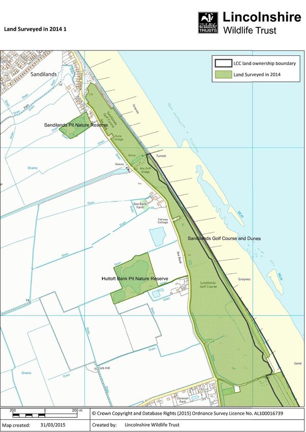
CONTENTS

                                                                                                     Page

1    Introduction ...................................................................................... 1

2    Lincolnshire Coastal Country Park ................................................... 2

3    The Study Area ................................................................................ 2

4    Surrounding Land ............................................................................ 2

5    Sources of Information ..................................................................... 3

6    Statutory Sites of Nature Conservation Importance.......................... 4

7    Non-Statutory Sites of Nature Conservation Importance .................. 4

8    Agri-Environment Schemes and Management Plans ....................... 5

9    Species Protection and Action Plans ............................................... 6

10   Local Wildlife Site Survey Techniques ............................................. 7

11   Overview of Habitats ........................................................................ 8

12   Site Descriptions .............................................................................. 9

13   Habitat Management...................................................................... 13

14   Further Management Issues .......................................................... 16

15   Threats .......................................................................................... 17

16   Management Objectives ................................................................ 19

17   Management Prescriptions ............................................................ 19

18   Work Plan ...................................................................................... 22

19   Measures of Success..................................................................... 22

20   Costs ............................................................................................. 23

21   Further Management Proposals ..................................................... 24

22   References .................................................................................... 25

23   Acknowledgements ........................................................................ 26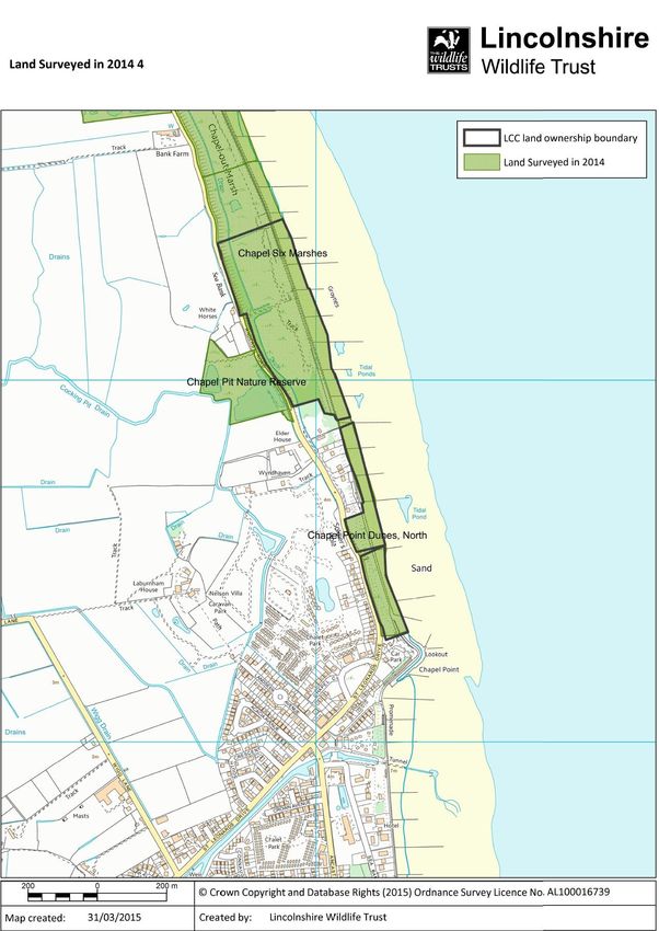
APPENDICES
Page
Map 1 Lincolnshire Coastal Country Park Boundary ................... 29
Map 2 Lincolnshire County Council Ownership Boundary........... 31
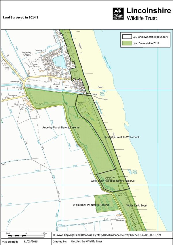
Map 3a Land Surveyed in 2014 (1) ............................................... 33
Map 3b Land Surveyed in 2014 (2) ............................................... 35
Map 3c Land Surveyed in 2014 (3) ............................................... 37
Map 3d Land Surveyed in 2014 (4) ............................................... 39
Map 4a Nature Conservation Areas (1) ........................................ 41
Map 4b Nature Conservation Areas (2) ........................................ 43
Map 4c Nature Conservation Areas (3) ........................................ 45
Map 5a Habitat Areas (1).............................................................. 47
Map 5b Habitat Areas (2).............................................................. 49
Map 5c Habitat Areas (3).............................................................. 51
Map 5d Habitat Areas (4).............................................................. 53
Map 6a Management Areas (1) .................................................... 55
Map 6b Management Areas (2) .................................................... 57
Map 6c Management Areas (3) .................................................... 59
Map 6d Management Areas (4) .................................................... 61
LINCOLNSHIRE COASTAL COUNTRY PARK
LINCOLNSHIRE COUNTY COUNCIL LAND
NATURE CONSERVATION MANAGEMENT PLAN 2015 to 2020
1. INTRODUCTION
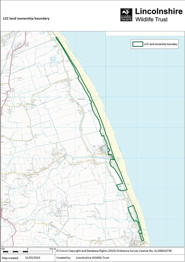
1.1. The Lincolnshire Coastal Country Park (LCCP) is a 35 square kilometre area on the
North Sea coast of Lincolnshire between Sandilands in the north and Chapel St
Leonards in the south (see Map 1 & Section 2). Much of the seaward edge of the
park is owned by Lincolnshire County Council (LCC), where important coastal
habitats are visited by large numbers of tourists and local residents every year (see
Map 2). This management plan refers primarily to the area shown on Map 2, but
also considers neighbouring land to the west.
1.2. Major aims of this document are to describe the habitats present and to outline
realistic management objectives over five years, with the aim of benefitting the flora
and fauna and accommodating the need for continued substantial public access.
1.3. Relevant reports, data and background information considered during compilation
of this management plan are outlined in Section 5. The author also carried out field
surveys (primarily botanical) in 2014, with the dual purpose of informing the
management plan and providing data to allow selection of Local Wildlife Sites
(LWSs), where appropriate (see Sections 7, 10, et al).
1.4. Most of the sites shown on Map 2 are not currently managed, although there is
some recently created wetland. Management is undertaken more widely on
adjacent and nearby land, including Lincolnshire Wildlife Trust (LWT) nature
reserves and Sandilands Golf Course.
1.5. Two neighbouring sites in the coastal strip are known as Chapel Six Marshes. To
minimise confusion, the northern area, which is an LWT nature reserve, is hereafter
referred to as Chapel Six Marshes (LWT), whereas the southern area is referred to
as Chapel Six Marshes (LCC).
2. LINCOLNSHIRE COASTAL COUNTRY PARK
2.1. Following several years of planning and discussions, the LCCP came into being in
the late 2000s, when a Strategic Business Plan for 2009-12 was produced
(Tarttelin, 2009). Led by LCC, the other project partners are East Lindsey District
Council, Environment Agency (EA), LWT, Lindsey Marsh Drainage Board, Natural
England, National Farmers Union and National Trust.
2.2. The vision for LCCP refers to the creation of a dynamic and extensive area
providing high quality facilities for people and better protection for wildlife. A wide
range of inter-connected targets lie at the heart of the vision, which have been
grouped into the following four Strategic Aims:
A sustainable, varied and attractive coastal landscape, rich in wildlife and
attractive to visitors and residents in every season;
1
A new green tourism destination with high quality accessible natural green
space and opportunities to experience the area’s cultural and natural
heritage;
An associated visitor or heritage centre, observatories and interpretation
points; and
A vibrant, diverse and sustainable local community.
2.3. Funding up to the end of 2014 has come from a variety of sources, including LCC,
LWT, EA, Heritage Lottery Fund, WREN, Rural Development Programme for
England and Agri-Environment Schemes.
2.4. Some projects already completed within the park are: land purchase at Huttoft
Marsh (funded by LWT, LCC and EA) and Anderby Marsh (funded by WREN, LWT
and LCC); a new permissive path from Wolla Bank to Anderby Creek; an all-ability
path and wetland creation at Chapel Six Marshes (LCC); several refurbished car
parks; production of a series of walking leaflets; development of interpretation
facilities at main coastal sites; and production of an annual events programme.
3. THE STUDY AREA
3.1. As Map 2 shows, the land under consideration in this plan (hereafter referred to
usually as ‘the study area’) lies entirely east of the coast road, measuring 20m to
200m wide and 7.3km long. It is aligned approximately north-by-west to south-by-
east, parallel to the North Sea coast, with three very short breaks and one major
gap of 575m. Wolla Bank Reedbed nature reserve is owned by LCC, but did not
form part of the study area at LCC’s request, because it is managed by LWT.
3.2. Public usage dominates the coast here, and there are five car parking areas
accessed from the nearby coast road. One is in Anderby Creek, while further north
a large number of vehicles and visitors can be accommodated on the seaward side
of the dune ridge at Huttoft Car Terrace and on the landward side of the dune ridge
at Marsh Yard. To the south of Anderby Creek, there is a small car park at Wolla
Bank and a much larger area for cars at Chapel Six Marshes (LCC), both of which
are immediately inland of the dune ridge. Toilet blocks are present at all these car
parks, with the exception of Wolla Bank. From these and other access points,
visitors wander along the whole length of the LCC holding. Dog walking is a very
popular pursuit.
3.3. Two topographical features found almost throughout are a low fixed dune ridge and
a strip of shallowly sloping upper beach further east. In some locations actively
forming foredunes are present between beach and fixed dunes. The latter were
subject to re-modelling and subsequent shrub planting in the 1980s in order to
strengthen their sea defence capability.
3.4. Few further landscape features are present at the very narrow northern end of the
site. Further south the site widens, encompassing shallow landward dune slopes
that in places incorporate wetland, much of which has been recently created or
restored with nature conservation in mind.
4. SURROUNDING LAND
4.1. Many of the sites mentioned below are shown on Maps 4a, 4b and 4c.
2
4.2. Land to the east of the coast road, but outside the study area, comprises, in north to
south order:
Sandilands Golf Course LWS;
Huttoft Marsh nature reserve;
Arable fields;
Anderby Creek settlement, including a fishing lake;
Anderby Marsh nature reserve;
Wolla Bank Reedbed nature reserve, which is part of Sea Bank Clay Pits
Site of Special Scientific Interest (SSSI);
Wolla Bank South LWS;
Chapel Six Marshes (LWT) nature reserve. This land, together with Chapel
Six Marshes (LCC) has just become Chapel Six Marshes LWS;
Private houses and grounds.
4.3. Other nearby land immediately west of the coast road is mostly arable fields, plus
the settlement of Chapel St Leonards in the far south, but areas of nature
conservation interest, again in north to south order, are:
Sandilands Pit nature reserve (part of Sea Bank Clay Pits SSSI);
Huttoft Bank Pit nature reserve (part of Sea Bank Clay Pits SSSI);
Moggs Eye Sea Bank Ponds LWS;
Wolla Bank Pit nature reserve (part of Sea Bank Clay Pits SSSI);
Ridge-and-furrow grazing marsh field;
Chapel Pit nature reserve (part of Sea Bank Clay Pits SSSI).
4.4. The majority of the sites listed in Sections 4.2 & 4.3 were surveyed in 2014,
exceptions being:
All arable fields;
All settlements, private houses and grounds;
Moggs Eye Sea Bank Ponds LWS, surveyed in 2004;
Anderby Creek fishing lake;
Ridge-and-furrow field west of Chapel Six Marshes (LCC & LWT). This was
clearly worth investigation, but unfortunately the owner was unwilling to
permit entry.
5. SOURCES OF INFORMATION
5.1. In 2010, ESL (Ecological Services) Ltd carried out some wildlife surveys east of the
coast road in the Moggs Eye and Chapel Six Marshes (LCC) areas, with emphasis
on protected species (ESL, 2010). Management recommendations were also put
forward, some of which were incorporated into the major improvements that took
place in 2012. Some elements of the ESL final report have been used in this plan.
5.2. Lincolnshire Environmental Records Centre was asked to provide species data for
the study area, but unfortunately a general lack of precise location information
severely reduced the value of those records. Another problem was how to interpret
long lists of invertebrate data, many of which were not of recent origin.
5.3. Systematic ornithological surveys took place throughout the LCCP area over the
period 2008-12, forming part of a wider investigation organised by the Lincolnshire
Coastal Grazing Marshes Partnership (Tarttelin, 2013). Breeding and wintering
birds were surveyed to provide baseline data regarding density, numbers and, to
some extent, trends in the key bird species using the area. Furthermore, the work
allowed a meaningful assessment of habitat conditions and site management on the
3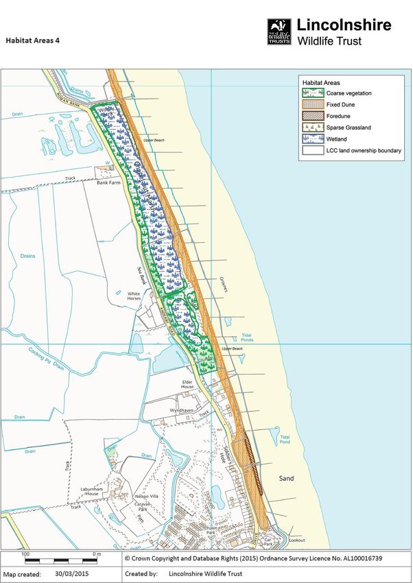
grazing marshes. One key finding was the importance of Higher Level Stewardship
       schemes and high-level water table management regimes for breeding waders and
       wildfowl. Although there is no grazing marsh owned by LCC between Sandilands
       and Chapel St Leonards, there is some immediately adjacent adding to the value of
       the coastal fringe from an environmental point of view.

5.4.   A detailed study of damselflies and dragonflies on or near the LCC land has taken
       place since 2012 (Bottomer & Bottomer, 2012, 2013 & 2014). Visits have been
       made to all the sites every weekend between the beginning of May and the end of
       October, except during two weeks in June and one in September, when the
       recorders were unavailable. The six recording areas are Huttoft Pit (SSSI),
       Anderby Creek to Wolla Bank, Wolla Bank Reedbed (SSSI), Wolla Bank Pit (SSSI),
       Chapel Six Marshes (LCC) and Chapel Pit (SSSI). A summary of the findings at
       Anderby Creek to Wolla Bank and Chapel Six Marshes (LCC) are included in
       Sections 12.1.4 and 12.1.5, below.

5.5.   LWT reserves staff and volunteers also provided useful information about reserves
       in and near the study area.

6.     STATUTORY SITES OF NATURE CONSERVATION IMPORTANCE

6.1.   National and international nature conservation designations protect the northern
       Lincolnshire coast (Humber Estuary and Saltfleetby-Theddlethorpe Dunes) and the
       southern Lincolnshire coast (The Wash and Gibraltar Point). However, the only
       biological SSSI near the study area is Sea Bank Clay Pits, which comprises five
       separate borrow pit areas totalling 16.8ha in size (see Maps 4a, 4b and 4c). These
       pits were excavated to provide clay to repair sea defences after the storm surge on
       31 January 1953. Since then, they have become flooded and colonised by a rich
       wetland flora; now all are LWT nature reserves. These reserves are all beside the
       coast road and comprise Sandilands Pit, Huttoft Bank Pit, Wolla Bank Reedbed,
       Wolla Bank Pit and Chapel Pit.

6.2.   Chapel Point to Wolla Bank is a geological SSSI (see Maps 4b and 4c) of
       importance for inter-tidal sediments that record sea level change in the early
       Holocene. The western edge of this site overlaps with upper beach sections of
       Chapel Six Marshes (LCC) and Chapel Point Dunes, North.

7.     NON-STATUTORY SITES OF NATURE CONSERVATION IMPORTANCE

7.1.   Before 2006, the non-statutory biological designation used by most local authorities
       in Lincolnshire was the Site of Nature Conservation Importance (SNCI), one of
       many equivalent names (see glossary in Greater Lincolnshire Nature Partnership,
       2013 and Annex A of Defra, 2006).

7.2.   At that time, selection of land for SNCI designation was mostly based on subjective
       opinions, but it was clear that more objectivity was required. Consequently,
       selection guidelines were published by the Lincolnshire Biodiversity Action Plan
       Partnership (now Greater Lincolnshire Nature Partnership) in line with national
       guidance (Defra, 2006). The Defra document introduced the name Local Site for
       application nationwide, instead of SNCI and all equivalent existing names. Every
       Local Site is either an LWS, where the interest is biological, or a Local Geological
       Site (LGS), where the interest is geological (see Section 7.5).

                                           4
7.3. Now in its 3rd edition, the selection guidelines (Greater Lincolnshire Nature
Partnership, 2013) provides the basis for selection of all LWSs in Lincolnshire.
7.4. From 2005 onwards, surveys have been commissioned throughout Lincolnshire to
reassess the value of SNCIs and, in some cases, to assess newly recognised sites
of nature conservation value. Subsequent selection or rejection as LWS has
resulted in a progressive reduction in number of SNCIs. However, in early 2014
most of the coastal LCC land in LCCP had not been fully assessed and was either
SNCI or had been identified as potentially of LWS quality. All of these areas have
now been assessed following the 2014 surveys, leaving only LWSs in the study
area.
7.5. Two SNCIs remain adjacent to the study area: Main Drain and two separate parts of
Huttoft Bank Dunes (see Maps 4a and 4b). Main Drain SNCI was last surveyed in
2004 and therefore needs to be reassessed as soon as possible; it is a large
canalised watercourse flowing eastwards along the northern boundary of Anderby
Marsh nature reserve. Some of Huttoft Bank Dunes SNCI has become LWS,
leaving Huttoft Marsh nature reserve (see Section 8.4.1) and part of an arable field
between Marsh Yard and Moggs Eye. The status of the nature reserve will be
reviewed by the LWS Panel in a few years when new habitats there have time to
settle down, whereas a decision on the arable land is expected before the end of
2015.
7.6. While the geological equivalent of LWS is LGS (see Section 7.2), the equivalent of
SNCI is Regionally Important Geological/Geomorphological Site (RIGS). Two RIGS
(which are to be re-assessed in 2015) are relevant to the study area: Huttoft Bank
Foreshore RIGS includes upper beach within Huttoft Car Terrace to Marsh Yard;
and Wolla Bank Foreshore RIGS includes upper beach within Anderby Creek to
Wolla Bank.
8. AGRI-ENVIRONMENT SCHEMES AND MANAGEMENT PLANS
8.1. No agri-environment schemes relate to the study area. This section describes
Environmental Stewardship agreements on adjacent land, at both Entry Level (ELS)
and Higher Level (HLS).
8.2. One HLS agreement applies to all LWT nature reserves in or near the study area,
including the five constituent parts of Sea Bank Clay Pits SSSI. These
predominantly wetland sites are subject to the following management prescriptions:
restoration and maintenance of reedbeds; cutting of wetland; restoration of species-
rich grassland; and maintenance of successional areas and scrub. Management
plans have not been produced, because all relevant matters form part of the HLS
agreement, which began in August 2010 and expires in July 2020.
8.3. Currently within the same HLS agreement is Anderby Marsh nature reserve, 23ha
of improved pasture and arable land purchased by LWT in September 2009.
Grassland has since been established throughout and water levels have risen as a
result of de-commissioning an Internal Drainage Board sluice at the northern end of
a south-north drain near its junction with Main Drain SNCI (see Section 7.5). HLS-
funded options here are: permanent grassland with very low inputs; maintenance of
grassland for wintering waterfowl and waders; creation of wet grassland for
breeding waders; and grazing supplement for cattle. To fulfil these requirements,
the main management tools used are cattle grazing and topping of vegetation. As
5explained in Section 8.2, LWT does not produce a separate management plan
where an HLS agreement is in force.
8.4. Two further nature reserves adjacent to the study area are being incorporated into
the Sea Bank Clay Pits HLS agreement at the time of writing. These are Huttoft
Marsh and Chapel Six Marshes (LWT), neither of which has a separate
management plan.
8.4.1. Huttoft Marsh was purchased in 2012 by LWT and LCC jointly, when it mostly
comprised unmanaged grassland, with some short-mown grass and several drains.
Towards the end of 2014 the site was subject to various drainage works, including
creation of shallow lagoons; it will now be managed under HLS to restore the
grassland for wintering waterfowl and waders.
8.4.2. The only management at Chapel Six Marshes (LWT) nature reserve in recent years
has been some scrub removal and occasional light grazing, plus the digging of a
trial pond in 2012 when major wetland creation was taking place to the north and
south. From now on, it will be managed by grazing from September to November to
fulfil the HLS option of restoration of sand dune systems.
8.5. The privately owned area south of Wolla Bank Reedbed and east of Wolla Bank Pit
nature reserve is referred to here as Wolla Bank South. As a result of recent
excavation there are now extensive reedbeds and areas of water, but with scope for
some rough grazing. HLS funded management comprises reedbed creation works,
as well as restoration of wet grassland, a grazing supplement for cattle and a
wetland grazing supplement. The agreement began in October 2011 and expires in
September 2021.
8.6. ELS agreement land adjacent to the study area occupies all the fields east of the
coast road between Huttoft Marsh nature reserve in the north and Anderby Creek in
the south. Here, the old sea defence, which is known as Roman Bank, is managed
as permanent grassland with very low inputs, but everything else is still arable with
4m buffer strips. The agreement began in January 2011 and expires in December
2015.
8.7. Details of the next generation of agri-environment schemes (Countryside
Stewardship) have not yet been finalised.
9. SPECIES PROTECTION AND ACTION PLANS
9.1. This section provides an outline of species protection at European level and
nationally. The relevance of Lincolnshire Biodiversity Action Plan is also
considered. All species mentioned are known to be present in the study area, or
have been recorded in the area or nearby in recent years, or could occur in the
area. Depending upon the species involved, the level of protection may vary from
comprehensive to far less so; for example common frog, common toad and smooth
newt are only protected with regard to sale.
9.1.1. Strongest protection is afforded to European Protected Species, which are listed on
Schedule 2 of The Conservation of Habitats and Species Regulations (2010).
These include otter, great-crested newt and all bats.
9.1.2. Domestic legislation covers the same group of species, plus a lot more. Under the
Wildlife and Countryside Act (1981, as amended), additional species listed on
6Schedule 5 are adder, grass snake, slow-worm, common lizard, smooth newt,
common frog, common toad, water vole and brown hare. Birds on Schedule 1 are
bittern, marsh harrier, hen harrier, bearded tit and Cetti’s warbler, which must not be
disturbed while breeding and are protected at all other times by special penalties.
9.1.3. Wild birds in general, as well as their eggs and nests, are protected under Part 1,
Section 1(1) of the Wildlife and Countryside Act. This means that habitat
management work between the beginning of March and the end of August can only
go ahead if an experienced ecologist confirms that there are no active nests in the
area, having first carried out a thorough search.
9.1.4. The Natural Environment and Rural Communities Act (2006, as amended) protects
further ‘Species of principal importance for the purpose of conserving biodiversity’.
These animals are listed under Section 41 of the Act, and include European eel,
turtle dove, skylark, linnet, yellowhammer, reed bunting, grasshopper warbler, song
thrush, dunnock, starling and house sparrow.
9.1.5. Protection of habitats and sites at European and national level is referred to in
Section 6.1.
9.1.6. The 3rd Edition of the Lincolnshire Biodiversity Action Plan (LBAP) is a non-statutory
publication concerned with sustainable conservation and enhancement of the
county’s biodiversity (Collop, 2011). It contains a series of locally focussed action
plans, each one relevant to a significant Lincolnshire habitat, species or group of
species. These action plans incorporate targets and actions, which were drawn up
with the intention that they would be SMART, ie specific, measureable, achievable,
realistic and time-limited.
9.1.7. LBAP habitat action plans of significance in the study area relate to Coastal Sand
Dunes and Reedbeds. Relevant LBAP Species Action Plans are those for Bats,
Farmland Birds, Newts and Water Vole.
9.1.8. The study area is also used by badgers, and under the Protection of Badgers Act
(1992) it is an offence to kill, injure or take a badger, and to recklessly interfere with
a sett.
9.1.9. Natural England must be contacted before carrying out any activities that may
impact upon protected species, as a licence may be needed.
10. LOCAL WILDLIFE SITE SURVEY TECHNIQUES
10.1. A document usually referred to as the Selection Guidelines (Greater Lincolnshire
Nature Partnership, 2013) is used when surveying, assessing and selecting
candidate LWSs. Key elements of that approach are described below, all of which
were followed in the 2014 surveys.
10.2. Once funding for surveys has been secured, the first step is to contact relevant
owners and occupiers to obtain permission for entry to their land. A letter is sent at
this stage, providing written evidence that the scope and possible implications of the
survey have been clearly explained. Then a survey is carried out within each
logical recording unit, which in some cases is a whole site and in others is part of a
site, ie a single field or a 1km stretch of linear habitat. It is normal to complete the
survey during one visit.
710.3. Botanical recording forms the major part of the survey, because many of the LWS
selection criteria require botanical data to allow assessment of habitat quality.
Typically, a qualifying site must support more than a threshold number of key plant
species listed in the Selection Guidelines, although a few criteria allow selection of
all acceptable examples of a particular scarce and valuable habitat.
10.4. In addition to plant identification, the standard survey involves incidental recording
of any fauna that can be quickly identified, ie birds, butterflies, day-flying moths,
dragonflies, damselflies and occasionally some distinctive members of other
groups. Survey of protected animal species is not normally carried out.
10.5. A wide range of other data is collected, for instance concerning the value and
condition of habitats present, topographical features, species frequency/abundance,
evidence of habitat management, and anything relevant about surrounding land. A
sketch map is often produced, perhaps annotated with useful information supplied
by the land manager/owner.
11. OVERVIEW OF HABITATS
11.1. The study area comprises: shallowly sloping sandy beach, foredunes (absent in
many places), fixed dunes and then low-lying areas inland of the dunes. The main
habitats present are sparse grassland, coarse grassland with scrub and trees, and
wetland. Maps 5a, 5b, 5c and 5d show where most of these features and habitats
occur, which are described below.
11.1.1. The extensive, gently sloping, sandy beaches on this part of the Lincolnshire coast
are mostly east of the study area, but some of the uppermost parts are included.
Although the bare sand is of little obvious botanical interest, Sections 12.1.5 and
12.1.6 refer to a geological SSSI near Chapel Point.
11.1.2. In many places, the next feature is a line of low fixed dunes, usually behind a
concrete sea wall and pathway. Much of this ridge is dominated by dense
vegetation, comprising species such as sea couch, marram, lyme-grass, common
reed, sea buckthorn, elder, dewberry, bramble, and in places plantations of pine
and other trees. Good grassland habitat is very scarce, largely because there is no
stock grazing and almost no cutting. However, hairy violet, lady’s bedstraw,
common knapweed, cat’s ear, oxeye daisy, tufted vetch and sand sedge were
located in the occasionally mown edge of a few tees on the eastern margin of
Sandilands Golf Course.
11.1.3. Between the beach and fixed dunes, immediately east of the sea defences, sand
has built up in places to form low foredunes. These are a younger stage in dune
formation, and consequently the vegetation cover is much lower than on the older
fixed dunes. Marram is one of the first species to colonise, but before long the
substrate becomes suitable for a number of associated species that only occur on
sparsely vegetated coastal sand, such as sea-holly, sea sandwort, prickly saltwort,
sea rocket, frosted orache and sand couch.
11.1.4. Shallow and fairly dry slopes landward of the dunes are dominated by coarse,
competitive plants. However, a short and sparse sward is able to survive where
visitor pressure is high, particularly in car parks and along paths. The diverse flora
here includes a large population of the localised strawberry clover, plus hare’s-foot
clover, buck’s-horn plantain, common cudweed, thyme-leaved sandwort, common
stork’s-bill, small-flowered crane’s-bill and fern-grass.
811.1.5. Wetland habitats are largely restricted to low lying areas west of the dunes between
Anderby Creek and Chapel St Leonards, some of which is considered by Natural
England to be a type of dune slack. Common reed is abundant along drains,
beside recently excavated water bodies, and in areas of wet and drier reedbed. A
wide range of other wetland plants include spiked water-milfoil, common fleabane,
angelica, meadowsweet, toad rush and greater pond-sedge. Further species
indicate brackish water conditions, such as brackish water-crowfoot, sea club-rush,
saltmarsh rush, sea-milkwort, lesser centaury and parsley water-dropwort.
11.1.6. Trees and scrub are prominent in many places, both wet and dry. While the lack of
grazing and cutting has allowed woody vegetation to colonise and spread naturally,
much scrub has developed after planting to stabilise dunes for sea defence
purposes. Tree planting has also occurred in places, most obviously inland of the
dune ridge.
12. SITE DESCRIPTIONS
12.1. The study area was divided into six compartments, each of which was surveyed
separately according to the LWS selection guidelines. Descriptions of each
recording unit are given below, starting at the northern end of the LCC land and
progressing southwards. Maps 3a, 3b, 3c and 3d show all areas surveyed in 2014.
12.1.1. Boy Grift Drain to Huttoft Car Terrace. This eastern part of Sandilands Golf
Course and Dunes (see Maps 3a and 5a) is a 1.5km stretch of beach and dune
varying in width from 20m to 70m. The site comprises, from west to east: parts of a
low ridge of fixed dunes; a concrete seawall and associated pathways; a parallel
strip of lower foredune in the southern half of the site; and shallowly sloping bare
sand at the top of the beach. It also includes the northern end of Huttoft Car
Terrace car park. The inland ownership boundary does not follow an obvious line
on the ground, thus including parts of the adjacent golf course in some places and
excluding much of the dune ridge in others.
The present morphology and vegetation of the fixed dunes was influenced by
landscaping and subsequent shrub planting in the 1980s, with the aim of improving
sea defences. Most of the planting was with sea-buckthorn, gorse and wild privet,
and these species are still prominent today, forming dense thickets, especially in
parts of the south. In spite of very little management, there are substantial scrub-
free areas, and although most of these support coarse grassland, there is also a
good selection of much more interesting plants, again mainly in the south. A flora
typical of good neutral grassland includes common bird’s-foot-trefoil, lady’s
bedstraw, hairy violet, common knapweed, tufted vetch, cat’s-ear, oxeye daisy,
lesser trefoil, yarrow, smooth hawk’s-beard and smooth meadow-grass. More
specialist coastal and dune plants are also present, such as hound’s-tongue, prickly
saltwort, sea rocket, sand sedge, marram, lyme-grass, sea couch and sea fern-
grass, the latter being very scarce in Lincolnshire and here found on the edges of
surfaced tracks. Further woody species include elder, bramble, dewberry and
woody nightshade.
The foredunes are between 5m & 20m wide and appear to be extending
northwards, because they become progressively narrower, lower and more sparsely
vegetated from south to north. It is the middle section which is of most botanical
interest, where a good range of plants have had time to establish, but the more
competitive species have not yet taken over. Many of the coastal species already
mentioned are present here, but plants restricted to the open sandy sward are
9around 25 specimens of sea-holly, as well as sea sandwort, frosted orache and
sand couch.
Butterflies and moths were conspicuous during the LWS survey, including ringlet,
gatekeeper, meadow brown, small & Essex skipper, common blue, small copper,
peacock, green-veined white, shaded broad-bar, yellow-tail and cinnabar. Some of
the birds seen were swallow, house martin, linnet, goldfinch, wren and starling.
12.1.2. Huttoft Car Terrace to Marsh Yard. This is a 1.2km long stretch of coast to the
south of Sandilands Golf Course and adjacent to Huttoft Marsh nature reserve (see
Maps 3a, 3b, 5a and 5b). It comprises: bare sand on the upper beach with some
botanically-poor foredunes; a concrete pathway and linear car parking area at the
top of the beach; a line of low, fixed dunes and flatter ground inland supporting
much unmanaged vegetation, dominated by dense scrub and trees in central and
northern parts, with larger amounts of grassland further south; and a gravel car
parking area inland of the dunes at the southern end of the site, characterised by a
short, open sward.
Woody vegetation on the fixed dunes includes pine, sycamore, sea-buckthorn,
elder, hawthorn, woody nightshade, bramble and dewberry. Other robust or weedy
plants here are marram, lyme-grass, common reed, sea couch, false oat-grass,
creeping & spear thistle, hedge & large bindweed, curled dock and amphibious
bistort. Species found in less vegetated sandy areas include prickly saltwort, sand
couch, hound’s-tongue, procumbent pearlwort, sea fern-grass and sand sedge.
The most interesting flora on site is typical of neutral soils. It is largely restricted to
the vicinity of the southern car park and along a track that extends northwards.
Present here are hare’s-foot & strawberry clover, lesser & hop trefoil, buck’s-horn
plantain, common bird’s-foot-trefoil, tufted vetch, meadow vetchling, yarrow, smooth
hawk’s-beard, autumn hawkbit, cat’s-ear, black medick, silverweed and smooth
meadow-grass. Damper habitat west of the car park supports dense willow scrub,
while further north of that there is much common reed.
Birds, butterflies and moths seen during the LWS survey included common
whitethroat, reed bunting, swallow, Sandwich tern, Essex skipper, painted lady, red
admiral and cinnabar.
12.1.3. Marsh Yard to Anderby Creek. This is a 1.75km long stretch of coast to the north
of Main Drain in Anderby Creek (see Maps 3b, 3c, 5b and 5c). Eastern parts of the
site comprise: bare sand on the upper beach with some young dunes; and a line of
low, fixed dunes supporting much coarse grassland and plentiful woody vegetation,
including many garden escapes in the south. Habitats inland of the dunes include
planted and naturally occurring trees and scrub on both dry and damp land,
grassland, sparsely vegetated car parking areas, a track and a little bare sand.
The northern end of the site is notable for supporting a huge population of the rather
scarce strawberry clover throughout a linear car park. A track extends south from
this to Moggs Eye, where a large patch of open grassland occurs. Few competitive
plants grow in these habitats and therefore the flora is rich in species typical of good
neutral grassland, such as common bird’s-foot-trefoil, cat’s-ear, lady’s bedstraw,
dove’s-foot & small flowered crane’s-bill, black medick and smooth meadow-grass.
Sparsely vegetated sandy areas here or on the dunes hold common cudweed,
annual pearlwort, common stork’s-bill, viper’s-bugloss, thyme-leaved sandwort,
fern-grass and sand sedge.
10Many parts of the dune ridge are dominated by coarse vegetation, such as marram,
lyme-grass, sea & sand couch, common reed and dewberry. Other weedy species
are hogweed, weld, red valerian, rosebay willowherb, fat hen, large bindweed,
creeping & spear thistle, hedge mustard and pineappleweed. Trees and shrubs
include white poplar, hybrid black poplar, pine, ash, buckthorn, sea-buckthorn,
buddleia, wild & garden privet, elder, hawthorn and ivy. South of Moggs Eye there
is a plantation of sycamore, with pine and horse chestnut. Damp areas, particularly
inland in the north, support osier, grey sallow, woody nightshade, comfrey,
amphibious bistort and silverweed.
Birds and invertebrates seen during the LWS survey included migrating whimbrel,
reed bunting, house martin, common blue, brown argus, meadow brown,
gatekeeper, peacock and common darter.
12.1.4. Anderby Creek to Wolla Bank. This is a 1.1km long stretch of coast on the
seaward side of Anderby Marsh and Wolla Bank Reedbed nature reserves (see
Maps 3c, 5c and 5d). It varies in width from 55m to 200m and comprises bare sand
on the upper beach; a line of fixed dunes; and substantial gentle slopes inland in
the north. Due to lack of management, most places support coarse and weedy
vegetation, with substantial cover of scrub and trees. Good open dune vegetation
is very limited in extent.
Extensive areas of woody vegetation on dry ground include large populations of
sea-buckthorn, elder, garden privet, bramble and dewberry, plus sycamore, apple,
woody nightshade and wild clematis. Also abundant is common reed, with
creeping, spear & welted thistle, prickly, smooth & perennial sow-thistle, common &
hoary ragwort, field & hedge bindweed, bristly oxtongue, common nettle, hemlock,
weld and soapwort. Other robust plants typical of sand dunes are sand & sea
couch, marram and lyme-grass.
Relatively small areas have much less coarse vegetation, particularly along well-
used paths and towards the outer edge of the dunes. This flora includes thyme-
leaved sandwort, dove’s-foot crane’s-bill, oxeye daisy, meadow vetchling, tufted
vetch, common bird’s-foot-trefoil, cat’s-ear, lady’s bedstraw, black medick and sand
sedge. Damper land is largely restricted to the western edge of the site, which is
adjacent to linear water bodies almost throughout. Here can be found common
fleabane, angelica, meadowsweet, sea club-rush, false fox-sedge, greater pond-
sedge and more common reed.
Fauna noted during the LWS survey were reed bunting, reed warbler, swallow,
wren, wood pigeon, speckled wood and common darter. Surveys by ESL in late
summer 2010 revealed two common lizards, but no evidence of water voles and
great crested newts. Also present are breeding Cetti’s warbler, willow warbler and
common whitethroat, plus wall brown butterfly and a large, active badger sett.
Detailed studies (Bottomer & Bottomer, 2012, 2013 & 2014) showed that there are
large populations of common blue, blue-tailed & azure damselfly, and common &
ruddy darter. Smaller numbers of migrant hawker, emperor, four-spotted chaser,
black-tailed skimmer and hairy dragonfly are also present. However, there is very
little open water on site and many of the dragonflies are likely to be breeding in
Wolla Bank Reedbed, where there is plenty of open water and good amounts of
surface vegetation.
12.1.5. Chapel Six Marshes (LCC). This is a 0.5km long stretch of coast north of Chapel
St Leonards, bounded to the west by Anderby Road and to the north by Chapel Six
11Marshes (LWT) nature reserve (see Maps 3d and 5d). In the east is the upper part
of a shallowly-sloping sandy beach, which is within Chapel Point to Wolla Bank
geological Site of Special Scientific Interest. The adjacent sand dune ridge is also
included, west of which are visitor facilities and two recently created wetland areas.
Habitats present are bare sand, short vegetation in car parking areas, coarse
grassland, a little open water, much reedbed, and varying cover of trees and scrub.
The resulting flora is diverse and interesting.
In contrast to all other parts of the study area, this site was subject to major
improvements during the period 2011-12, comprising both habitat works and
upgrading of visitor facilities. In habitat terms, the main result is many new inter-
connected linear waterbodies to north and south of the entrance road. Although
now largely obscured by vigorous reed growth, the huge increase of water’s edge
habitat was designed to augment wetland biodiversity in areas that had previously
been much drier.
Dense common reed restricted opportunities to survey the aquatic flora, but spiked
water-milfoil, water-crowfoot and duckweed were recorded. Other wetland species
were toad & saltmarsh rush, sea club-rush, parsley water-dropwort, wild celery,
angelica and common fleabane.
Common reed also occurs on the sand dune ridge, with marram, lyme-grass, sand
& sea couch, sand sedge, sea sandwort, dewberry and plentiful sea buckthorn.
Woody vegetation is prominent at the southern end of the site, on the embankment
along the entire western boundary, and in wetter central areas. Here species
include pine, white poplar, goat, white & crack willow, osier, grey sallow, blackthorn,
hawthorn, ivy, wild & garden privet, elder, dog-rose, bramble and woody
nightshade.
Recent improvements for visitors have included creation of a circular path in the
southern half of the site. This has provided opportunities for colonisation by
grassland plants, although most of the interesting flora is associated with the
landward slope of the dune ridge and the open sward in car parking areas. Some
of the neutral grassland species in these places are common knapweed, meadow
vetchling, tufted vetch, oxeye daisy, autumn hawkbit, meadow buttercup, yarrow,
smooth tare and red fescue. Opportunists of open and disturbed ground include
buck’s-horn plantain, common stork’s-bill, small-flowered & dove’s-foot crane’s-bill,
black medick, wild mignonette, sticky groundsel, silverweed and annual meadow-
grass. Coarse grassland comprises species such as creeping & spear thistle,
hogweed, rosebay & great willowherb, comfrey, cow parsley, hedge & large
bindweed, curled dock, Yorkshire-fog, common couch, wood small-reed and false
oat-grass.
Fauna noted during the LWS survey were moorhen, migrating whimbrel, wood
pigeon, green-veined white, small tortoiseshell and common darter. Surveys by
ESL in late summer 2010 revealed three common lizards, plenty of evidence of
water voles and no great crested newts. Also present are breeding Cetti’s warbler
and sedge warbler, little grebe in winter and wall brown butterfly; otters have been
seen nearby and signs noted within the site.
Detailed studies (Bottomer & Bottomer, 2012, 2013 & 2014) showed that there are
large populations of common blue & blue-tailed damselfly, four-spotted chaser, and
common & ruddy darter. Smaller numbers of small red-eyed damselfly, migrant
hawker, broad-bellied chaser, emperor, black-tailed skimmer and hairy dragonfly
are also present. Although the recent habitat improvement works created much
12open water, the great majority of this is now dominated by common reed, and that is
limiting the suitability of the site for both damselflies and dragonflies.
12.1.6. Chapel Point Dunes, North. This 0.62km long stretch of coastline (see Maps 3d
and 5d) comprises two main elements. In the east is the upper part of a shallowly-
sloping sandy beach, which is within Chapel Point to Wolla Bank geological Site of
Special Scientific Interest. Elsewhere, in central and southern parts, there are
heavily scrubbed-up fixed dunes, which also support some coarse grassland.
Plants of good quality dunes are few in number, but include marram, lyme-grass,
sea & sand couch, hound’s-tongue, sea bindweed, prickly saltwort and sand sedge.
Neutral grassland species also occur sparsely, and are represented by common
bird’s-foot-trefoil, autumn hawkbit, lady’s bedstraw, meadow vetchling, yarrow,
silverweed and black medick. In contrast, plants typical of unmanaged sand dunes
near habitation are abundant, such as horse-radish, creeping thistle, hedge
bindweed, ground-elder, cow parsley, field horsetail, common ragwort, ivy, Russian-
vine, hogweed, amphibious bistort, common reed and false oat-grass. Woody
vegetation includes sea-buckthorn, elder, hawthorn, grey sallow, cultivated rose,
bramble, dewberry and honeysuckle.
Fauna noted during the LWS survey were common blue, ruddy darter and common
darter.
13. HABITAT MANAGEMENT
13.1. Habitat management in the study area is currently minimal. Some commonly used
management techniques that could be adopted are: stock grazing; removal of
vegetation by flail collector or by hay-making; flailing and leaving cut material;
planting of trees and scrub; removal of trees and scrub by cutting; use of herbicide;
and periodic excavation of existing and new waterbodies. Merits and drawback of
each of these are discussed below, and then Section 14 goes on to explore five
additional issues that have particular local significance.
13.1.1. Appropriate grazing is one of the most valuable means of maintaining a botanically-
rich sward in grassland areas. Generally, any grazing is better than none at all,
because unmanaged grassland becomes increasingly dominated by competitive
and robust plants that are common and widespread in the wider countryside.
Grazing reduces the vigour of this coarse vegetation and provides opportunities for
short-sward and sparse-sward species to survive, especially if there is also some
ground disturbance from hooves. In many cases, low to moderate grazing pressure
can result in a habitat mosaic of bare patches, short and longer grassland,
scattered and perhaps denser scrub, and a few trees. Such mosaics can be
excellent habitat for a range of invertebrates and other fauna. Grazing by cattle is
preferable to sheep, because the former are less discriminating, so take more of the
coarse vegetation and leave more of the shorter species, plus their hooves create
more bare ground. Un-vegetated patches are good if scarce species germinate, but
less good if the weed flora is encouraged! The highly selective grazing of equines,
their tendency to create highly nutrient-rich latrine areas and ability to encourage
ragwort and other weeds need very careful husbandry if the outcome is to be
sufficiently beneficial. Rabbit grazing has positive and negative aspects, but there
is usually a net benefit, especially in the absence of other management.
13.1.2. If grazing is not feasible, another means of counteracting scrub encroachment and
encouraging a diverse sward is by mechanical removal of vegetation. This is more
13effective than grazing in reducing soil fertility, but has an adverse effect on
invertebrate populations. The traditional approach is to make hay annually in late
summer, which takes several days if the weather is good, or longer if it is not.
Another option is to use a flail collector that cuts and removes in one operation, with
obvious advantages of greater speed and lower cost, plus a need for only one day
of good weather. However, this technique is far more harmful to invertebrates than
hay-making and therefore is perhaps most appropriate for occasional use on very
coarse vegetation with little invertebrate interest, or to prepare for (re-)introduction
of grazing. If the aim is to manage coarse vegetation annually, it would be
appropriate to use a flail collector at first, with the intention of switching to hay-
making if the sward improves.
13.1.3. Reduction of soil fertility will be minimal if cut vegetation is left on the surface,
because most of the nutrients released by the rotting process will return to the soil.
Another disadvantage of leaving cut vegetation is the covering up of bare ground
that would otherwise be suitable for successful germination of many desirable
species. In addition, arisings can smother and adversely affect the basal parts of
plants that have had most of their above surface parts severed. Thus, in many
cases occasional cutting and not removing arisings is a worse option than no
cutting at all. However, if cutting occurs frequently throughout the growing season,
some of the negative impacts are minimised, and on sandy soil a restricted range of
desirable plants will be able to survive, such as the rarer clover species.
13.1.4. Generally, planting of woody vegetation on grassland, heathland, wetland or other
semi-natural habitat that normally supports few trees and shrubs should be strongly
discouraged. Such planting impedes mowing, reduces grazing opportunities, casts
shade, changes soil characteristics and can cause the replacement of scarce and
valuable habitat by common shade-tolerant and nutrient-loving species. Of even
greater concern, is the planting of trees and shrubs that are not native or are not
suited to the location.
13.1.5. Removal of trees and shrubs from previously open habitats is an often used
management technique, although it is more beneficial for some species than others,
and for many can be a disadvantage. Some difficulties associated with removing
woody vegetation include:
A felling licence is required from the Forestry Commission before significant
amounts of tree felling take place (this is relevant to Prescription 8, Section
17.1.8). On dunes, a felling licence may be difficult to obtain, because
Forestry Commission may consider that a ‘change of character’ would
result.
Removing trees and scrub is likely to lead to a profusion of woody regrowth,
unless there is considerable investment in ongoing appropriate
management, such as immediate stump treatment with herbicide followed
by adequate levels of grazing or further cutting in succeeding years;
Even if there is follow-up management, clearance of well-established scrub
and woodland is likely to result in regrowth of undesirable vegetation in the
enriched soil, such as willowherb, nettles, docks and thistles;
Scrub is an excellent habitat for breeding warblers and other fauna that
require shade, shelter, etc;
Scrub is a vital source of food for many species, for example thrushes
feeding on berries in the autumn and winter;
Removal of scrub on sand dunes that perform a sea defence role may be
considered undesirable by EA;
There may be public disquiet at the ‘destruction of habitat’.
14Some reasons for removing woody vegetation are:
In an ideal state, the study area would support few trees, and all of those
would be native species appropriate to the situation, such as willows in
wetlands and ash on damp and fairly fertile soils. In addition, the dunes
would be treeless, with a scatter of scrub, and would support much
botanically-rich dune grassland. Today this stretch of coast is dominated by
scrub, trees and coarse grassland;
Scattered young scrub is unlikely to cause significant changes to the soil in
which it is growing, so there is a good chance that desirable grassland
species will re-colonise promptly once the scrub has gone;
Scattered young scrub may be cheaper and easier to remove than
established clumps;
Dense old scrub is worth removing in order to prevent further scrub
encroachment into adjacent species-rich grassland;
Dense old scrub is also worth removing if this facilitates other management,
ie provides access for grazing animals;
Some scrub supports large numbers of the brown-tail moth on the
Lincolnshire coast, which cause health problems in humans if hairs on the
larvae are inhaled or make contact with the skin;
Trees and scrub attract a range of predators (particularly corvids) and wood
pigeons. This is highly unfortunate because major efforts are taking place in
the vicinity to encourage birds and other fauna that are highly susceptible to
predation. Examples of groups under threat here are breeding waders and
wintering waterfowl in the Huttoft Marsh and Anderby Marsh nature
reserves, plus the fauna of reedbeds in Chapel Six Marshes (LWT & LCC).
13.1.6. Carefully targeted herbicide application can be a very useful tool for minimising
regrowth after woody vegetation has been cut, particularly when it takes the form of
stump treatment immediately after cutting. Spot treatment or weed-wiping are also
acceptable in certain circumstances, but it is best to avoid any techniques that may
adversely affect non-target flora and fauna.
13.1.7. Ponds, lakes, marshes, fens and reedbeds are subject to natural successional
change if no management is carried out. This means that over a period of perhaps
several decades the area and depth of water gradually decreases, leading to the
loss of aquatic species, then loss of other water plants, and eventually the site
ceases to be wetland. In order to maintain a good range of wetland types in an
area, one approach is to excavate a new wetland every ten years or so and do
nothing else to interfere with natural processes. Alternatively, relatively small scale
excavation can be carried out relatively frequently on an existing wetland, on
rotation, with the aim of retaining a range of habitat types indefinitely. Other actions
that can hold back succession include minimising tree cover, and cutting and
removing reeds.
Major excavation works at Chapel Six Marshes (LCC) in 2012 have been extremely
successful in creating significant areas dominated by common reed. While reedbed
is an important habitat, on this site the numerous linear water bodies were created
to produce a mosaic of wetland types, far richer in flora and fauna than a
monoculture of reeds. Indeed, the ESL report envisaged an outcome of 25-30%
open water, 40-50% wet reed, 15-25% drier reed and 5% scrub (ESL, 2010).
Therefore, there is an urgent and ongoing need to manage the reeds by rotational
cutting and removal of cut material. This would maintain a mixture of: reedbed;
shallow edges where sunshine can penetrate to the water’s surface, supporting a
15diverse wetland flora and fauna; and open water with plentiful aquatic plants and
animals.
14. FURTHER MANAGEMENT ISSUES
14.1. The future of the study area will also be affected by factors of more local relevance,
namely: establishment of the National Coast Path; the conservation of sea-
buckthorn; re-wetting of land south of Anderby Creek; beach nourishment or other
flood risk management measures; and cabling coming ashore from Triton Knoll
wind farm.
14.1.1. Plans are advancing to create a path around the entire coast of England, with the
section between Boston and Cleethorpes planned for completion in 2020. The
precise route will soon be finalised, but impacts on the coastal strip will depend on
whether it follows the dune top, the landward dune foot or the seaward dune foot. If
a view of the sea is important then the landward option would not be appropriate,
but all three options are problematic. If the path is to have a hard surface wide
enough to accommodate walkers, cyclists and horse riders, then construction on
the dune top would have a considerable footprint in order to maintain sea defence
capability. It might be feasible to utilise existing hard surfaces on the seaward foot
of the dunes, but this location is vulnerable to high tides and storm surges. Another
drawback of the inland option is the significantly increased threat of disturbance
(particularly by dogs) to breeding birds and other fauna associated with dune scrub,
grassland and reedbeds in the vicinity. There is already increased disturbance
along the route of the new permissive path south of Anderby Creek, where the only
practical solution appears to be fencing of sensitive areas to exclude walkers, plus
provision of signage requesting that dogs are kept under control and not allowed to
enter the fenced compartments (see also Section 21.1.6).
14.1.2. Sea-buckthorn is considered to be native on eastern coastal dunes from East
Sussex (Dungeness) north to Dunbar in East Lothian (Dargie, 2002), but elsewhere
it has been widely introduced, primarily to encourage dune stabilisation. The
species is invasive and has increased in extent greatly in recent decades as grazing
pressure from livestock and rabbits has decreased, particularly since myxomatosis
appeared in the 1950s. This has occurred in areas where the plant is native as well
as where it is not native, with a consequent loss of species-rich dune grassland. As
a result, considerable resources have been expended in trying to control or
eradicate sea-buckthorn throughout its current range. However, this approach
should be questioned where the plant has not been artificially introduced, because
the EU Habitats Directive identifies sea-buckthorn scrub as a unique and special
component of the habitat mosaic in dune systems. Furthermore, the main site
identified as a Special Area of Conservation (SAC) in the UK on account of its sea-
buckthorn habitat is Saltfleetby-Theddlethorpe Dunes and Gibraltar Point SAC (a
Natura 2000 site). Thus, although the study area lies outside the SAC, it is in the
middle of the 25km gap between its northern and southern parts. Therefore, it
would seem prudent to not advocate wholesale sea-buckthorn removal in the study
area. However, one complication is that sea-buckthorn was definitely planted along
the dunes north of Huttoft Car Terrace – see Section 12.1.1.
14.1.3. Under an HLS agreement, LWT would like to raise water levels substantially on
Anderby Marsh Nature Reserve to create/improve wetland and grazing marsh
habitat, and to benefit breeding and wintering birds. So far, a modest amount of re-
wetting has been achieved by installation of a tilting weir on the decommissioned
drain flowing north into Main Drain. Re-positioning of the weir could raise water
16You can also read