Implementation Advisory Committee - Feasibility Study for the Belmont Community Path - Town of ...
←
→
Page content transcription
If your browser does not render page correctly, please read the page content below
Feasibility Study for the

  Belmont Community Path

          Submitted to:
    Belmont’s Community Path
Implementation Advisory Committee

  Prepared November 2017 by
TABLE OF CONTENTS

       DESCRIPTION                                  PAGE

       Executive Summary                              1

       Introduction                                   3

              Project History                         3

              Purpose                                 4

              Process                                 5

       Site Understanding                             7

              Safety Review                           8

       Public Engagement                              9

              Public Input                            10

              Design Guidelines                       11

       Alternative Development                        13

       Evaluation                                     40

              Cost Estimating                         43

              Recommended Route                       48

              Funding                                 50

       Moving Forward                                 51

              Next Steps for Belmont                  51

              Future Decisions                        54

   i   Belmont Community Path – Feasibility Study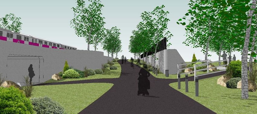
Appendices

     Appendix A        Crash Data

     Appendix B        PEP Plan/Formal Presentations

     Appendix C        Public Input

     Appendix D        Crime, Economic Impact and Safety of Multi‐Use Paths

     Appendix E        Matrix Definitions/Completed Matrix

     Appendix F        Alternative Costs

     Appendix G        Property Impacts

     Appendix H        Funding Coordination

ii   Belmont Community Path – Feasibility Study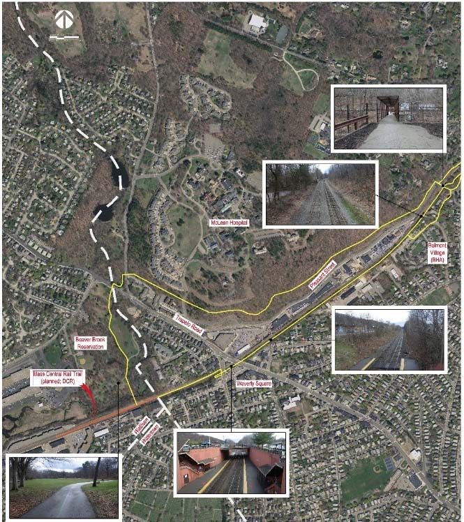
EXECUTIVE SUMMARY
The Town of Belmont, a densely settled urban area, suffers from worsening traffic congestion
unbalanced with a desire to advance healthy living initiatives. A multi‐use path will provide
opportunities for healthy recreation, an alternate mode of transportation for short commutes
and great connections to existing transit stations for longer commutes.
After 20 years of independently pursuing a multi‐use path, the Town of Belmont has procured
a formal feasibility study aimed at identifying a recommended route for the path to move
forward to design and construction. The following represents an account of the process and
findings of this Feasibility Study.
The essence of the proposed multi‐use path is to create a designated space for non‐motorized
activity along an alignment that meets the Americans with Disabilities Act (ADA) guidelines
for access and use. The project limits extend over two miles from the border with Waltham
to the border with Cambridge, running adjacent or in close proximity to the active Fitchburg
commuter rail line operated by the Massachusetts Bay Transportation Authority (MBTA).
While many potential routes advanced from efforts of the antecedent Community Path
Advisory Committee (CPAC), additional routes were added as part of this feasibility study,
particularly in areas where previously defined alignments were likely infeasible based on
state, MBTA or ADA requirements.
To ensure the proposed path could serve the greatest user base, potential users needed to be
identified. As noted, the path is intended for recreational use as well as commuting. Thus,
potential users include all Belmont residents as well as residents and users from adjacent or
connected communities. The path will immediately connect to the existing Fitchburg Cutoff
path in Cambridge, providing access to the Alewife Station and points beyond along the
Minuteman Bikeway and Alewife Greenway Path. It is likely that upon opening the path would
connect to points westward as well, including portions of the Mass Central Rail Trail (MCRT)
in Waltham and Weston, which are currently in the design phases.
Primary components of the multi‐use path include connections to major town amenities,
other recreational uses and transit. More specifically, key points identified for connection
within town include the Beaver Brook Reservation, Waverley Square, Belmont Center,
Waverley Station, Belmont Center Station, schools and amenities along Concord Avenue such
as the library, pool and music school.
To advance from the various potential alternatives to a single recommended route, a process
was established to identify and rank the feasibility of each alternative and to justify the
combination of alternatives into an overall route. The process included:
site understanding, using a combination of GIS mapping and field visits;
public engagement, to elicit and consider input from the town and all potential users;
design, to provide conceptual representation of what each alternative would entail;
evaluation, via a matrix style approach that evolved with the project;
cost, to provide anticipated construction costs in current dollars for each alternative;
1 Belmont Community Path – Feasibility Study
funding, to identify potential sources and establish a path forward; and
recommendations, for the primary path route and contingency routes, as well as
future funding, phasing and spurs.
Ultimately, the recommended route would: begin on the north side of the rail at the
Waltham/Belmont town line; continue along the north side of the rail to the Waverley Square
station, where a “box‐over” park would be constructed; continue along the south side of the
rail, through the DPW site, to the west side of the Housing Authority office building; cross the
rail on a bridge structure; continue along the north side of the rail to Alexander Avenue,
utilizing the existing Concord Avenue overpass structure; cross under the rail at Alexander
Avenue via a depressed, retained path; and then proceed along the south side of the rail on
the Belmont High School property, and subsequently the Purecoat North/Crate Escape
property, to an at‐grade crossing of Brighton Street and the Fitchburg Line.
This route carries a total estimated construction cost of $27.9 Million, not inclusive of right‐
of‐way costs that will be required for agreements and/or partial acquisitions. This route
utilizes the greatest extent of town owned and operated property, and would allow for future
spur connections to all identified points not included within the initial route. It is also the
most direct route, which has been identified as ideal for maximizing state funding. While this
is the recommended route, deemed most feasible by the study, there are a few obstacles that
the town will need to work out internally in order to implement. Should any of these obstacles
become insurmountable, contingent routes have been identified.
Ideally, the recommended route would be endorsed by the Community Path Implementation
Advisory Committee (CPIAC) and relayed to the Board of Selectmen (BOS), who will make the
final decision on the path route. Following the BOS decision, the project can proceed to design,
permitting, funding and right‐of‐way (ROW) agreements and acquisitions, as necessary. If all
elements continue to move forward with minimal delay, the proposed path could be
constructed as early as 2022.
2 Belmont Community Path – Feasibility Study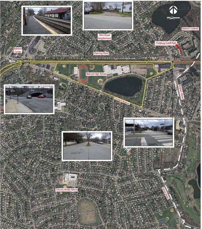
INTRODUCTION
The Belmont Community Path is envisioned to be a shared‐use resource for basic modes of
transportation like walking, jogging, bicycling, in‐line skating, and other non‐motorized
forms of mobility. This Community Path would connect Belmont into a growing network of
walking and cycling routes present and developing in the nearby communities, including the
existing Fitchburg Cutoff and Minuteman paths, and the planned Mass Central Rail Trail
(MCRT). A Community Path offers a wide range of possible benefits, such as providing a safe
place for healthy activities by people of all ages and abilities, improving air quality, helping to
relieve traffic congestion, stimulating local businesses, and enhancing Belmont as a place
where people want to live, work, and shop.
This proposed path is a key component of the Town’s future economic and transportation
viability as outlined in Belmont’s 2010 “Comprehensive Plan.” The development of a multi‐
use path through Town, with immediate connections eastward towards Boston and
surrounding communities, and additional planned connections to the west, as well as
connections to Belmont’s bus and commuter rail stations, will provide opportunity for those
travelling within or commuting through Belmont to seek an alternate transportation mode,
reducing vehicular use within Town. Identified as a priority by both the Town and the
regional planning agencies, including the Metropolitan Area Planning Council (MAPC) and the
Central Transportation Planning Staff (CTPS) of the Boston Region Metropolitan Planning
Organization (MPO), this piece of the MCRT is a critical link to connecting all areas outside of
District 6 with the Boston area.
PROJECT HISTORY
This feasibility study is the culmination of over 20 years of studies and planning associated
with the Belmont Community Path. Below is a brief summation of the key components of the
path’s history:
1994: With potential for federal funding, the Town’s Board of Selectmen (BOS)
formed the Bikeway Planning Committee.
1997: Proposal for a multi‐use path through Belmont started to advance as part of the
Mass Central Rail Trail (MCRT) planning process. Belmont was included (at the
Town’s request) in the 1997 CTPS MCRT feasibility study.
1997: The Wallace Floyd Group prepared the Belmont Bikeway Preliminary
Feasibility Analysis.
1998: MCRT progression stalled due to lack of funding and lack of participation from
some communities along the route; a few communities, including Cambridge,
proceeded independently.
3 Belmont Community Path – Feasibility Study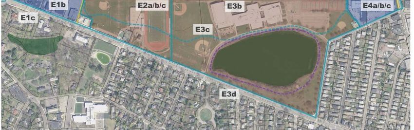
2010: Construction began on the Fitchburg Cutoff Path, which stretches from the east
side of Brighton Street in Belmont to the Massachusetts Bay Transportation
Authority’s (MBTA) Alewife Station in Cambridge.
2010: DCR signed a 99‐year lease for the abandoned Central Massachusetts Railroad
(CMRR) corridor from Beaver Street in Waltham westward to Berlin.
2012: The “Belmont/Waltham Community Trail Alignment Study” was published by
the Metropolitan Area Planning Council (MAPC).
2012: The BOS appointed a Community Path Advisory Committee (CPAC), consisting
of volunteer Belmont residents and a local business owner, to review previous efforts,
obtain public input and recommend alignments (below) for the Community Path.
ROUTES ADVANCING FROM CPAC
2014: CPAC delivered its final report and recommendations to the Town.
2015: BOS appointed the Community Path Implementation Advisory Committee
(CPIAC), consisting of volunteer residents and one local business owner, to prepare a
request for proposals (RFP) and select a qualified consultant to identify and evaluate
feasible routes for a Belmont Community Path, including evaluation of the 2014 CPAC
recommendations.
PURPOSE
The purpose of the Belmont Community Path Feasibility Study is to: recommend to the
Community Path Implementation Advisory Committee (CPIAC) a preferred alternative for a
4 Belmont Community Path – Feasibility Study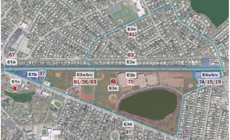
non‐motorized, multi‐use community path through Belmont that will serve the Town’s
    residents as well as “fill the gap” along the Mass Central Rail Trail (MCRT) between Waltham
    and Cambridge, using the alignments from the Community Path Advisory Committee (CPAC)
    as a base, while also considering new solutions to the most vexing path segments; develop,
    with public input, an evaluation process that ensures the selected alternative is justified;
    develop all alternatives and associated cost estimates to a conceptual level; and begin
    coordination regarding funding of the path to enable the Town to continue moving forward
    efficiently through design and construction.

    PROCESS

    The feasibility study for the Belmont Community Path included several important phases,
    namely: site understanding; public engagement; design; evaluation, including cost estimating
    and funding; and recommendations. These stages were not exclusively independent, and
    frequently overlapped.

    The site understanding phase consisted of extensive field walks, a compilation of
    information from GIS databases, data collection and review, as well as the assessment of
    existing conditions from both an engineering and landscape architecture perspective.
    Inherent in the data collection and review portion of this stage was a thorough review of all
    previous documentation related to the path, as well as ongoing coordination with the Town
    regarding Town characteristics that may impact any given alternative.

    The public engagement phase was initiated by determining the entirety of stakeholders,
    including Town departments and committees, the Town’s residents, the potential path users
    from neighboring communities, local businesses and state agencies such as the MBTA and
    DCR. This phase also entailed defining for the project the level of collaboration anticipated
    for the identified stakeholders as well as presenting information to and obtaining feedback
    from the stakeholders through the development and implementation of a robust public
    engagement plan.

    Design for all alternatives of the path, both carried forward from CPAC and developed as
    alternates, was done preliminarily with AutoCAD Civil 3D software. This allowed the design
    to evolve in a manner that accounted for compliance with the Americans with Disabilities Act
    Accessibility Guidelines (ADAAG). With many of the alignments under consideration being
    rail‐with‐trail, where the path will abut the Fitchburg line of the active MBTA commuter rail,
    the design also accommodated appropriate setbacks from the rail, as established through
    review of Massachusetts’ guidelines, including the MassDOT Project Development and Design
    Guide (PDDG), as well as coordination with the MBTA.

    The design of each alternative was completed to a conceptual level that would allow for the
    evaluation and comparison of each alternative. A matrix, containing 23 criteria, was
    developed, iterated and utilized as the primary evaluation tool. These criteria stemmed from

5   Belmont Community Path – Feasibility Study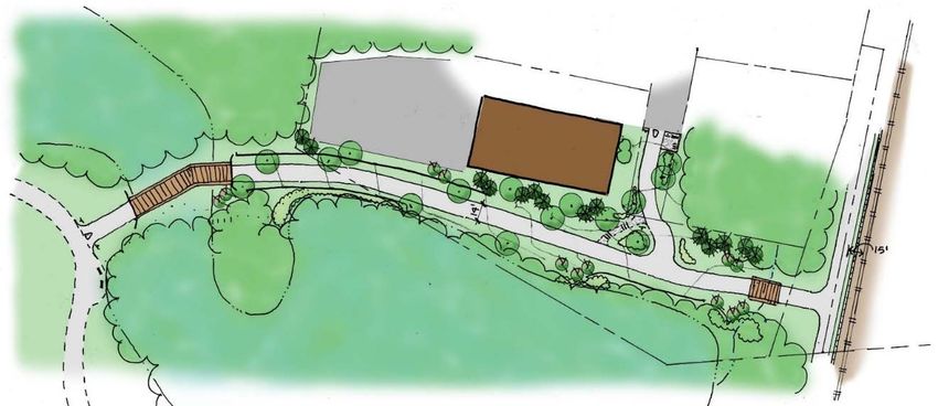
a combination of experience on similar feasibility and/or path projects and stakeholder input.
    Two key criteria included in the matrix, and essentially sub‐phases in the process, were
    construction cost and potential for funding.

    The cost estimating for each alternative consisted of, to the extent possible, unit costs based
    on typical cross sections. However, many structural and landscape components required
    more detailed analysis and quantification.

    The potential to garner funding was initially assessed within the matrix based on previous
    experience, focusing primarily on the type of property each alternative traversed, its level of
    consistency with the alignment planned for the MCRT and its potential for positive impacts
    on existing traffic congestion. As the study progressed, conversations were initiated with the
    state agencies most likely to contribute or administer funding, including MassDOT, MBTA and
    the MPO/MAPC. These conversations led to the recommendations for the Town.

6   Belmont Community Path – Feasibility Study
SITE UNDERSTANDING

       All potential path routes through Belmont will require impacts, temporary and permanent,
       to residents and/or privately owned commercial entities within Town, as well as to Town
       owned parcels. An initial inventory was completed of all existing land uses along the
       previously established alignments. In addition, a base map was developed using a
       combination of GIS and field collected data.

       To ensure the study results were as accurate as possible, for the goal of enabling the Town to
       move forward expeditiously with design, the first imperative of the project was to develop an
       encompassing base map. This base map was compiled using a combination of GIS data from
       both Town and State databases, field collected data as well as information gathered from the
       public via the Workshop.

       GIS data extracted included: topography, allowing for the extraction of 2‐foot contours;
       historical properties and structures; wetland limits; property, street and building
       boundaries; assessor’s information, focusing on property owner type; and rail lines.

                                            SAMPLE GIS MAPPING

       Field data collected over the course of several field walks, both with and without the public,
       were added to the GIS base map to expand the level of understanding. Elements added from
       field work included: Town resources and amenities, such as recreational areas and facilities,
       schools and restaurants; Town owned facilities, such as the DPW, Police Station and Light
       Building; and measurements in key locations, both vertical and horizontal, for verification of
       GIS data.

       Following completion of the initial base map, it was presented to the public at the Kick‐Off
       meeting, as well as reproduced for online consumption. Input gathered from all interested

   7   Belmont Community Path – Feasibility Study
stakeholders regarding constraints and opportunities were adjusted within the mapping as
necessary and/or considered during the subsequent alternative development.
With the base map developed to this level, the alternative development was able to utilize
AutoCAD Civil 3D to create alignments, profiles and cross sections. These computer‐drafted
objects became the foundation for all typical sections, running grade and cross slope
production and assessment to analyze offsets, impacts and ADA compliance.
In addition to providing information for verifying and expanding upon the base map, the field
visits were used to gather the existing conditions of the landscape in the areas proposed for
the various path alignments. The landscape of Belmont includes significant changes in
elevation resulting in some relatively steep slopes, most of which are wooded. The areas
along the proposed alignments that are currently open consist of both park lawn spaces and
more commonly low‐value natural landscape.
SAFETY REVIEW
To assist in comparing various alignments, crash data was extracted from the MassDOT Crash
Portal for the most recent five (5) year period available, from January 2010 through
December 2014. This data was assessed with regard to crash frequency and incident type.
This assessment assisted in the comparison of alternatives, particularly with respect to
identifying areas of existing safety concerns that may be worsened by the path’s
development. Mitigation, such as signalization or traffic calming, was considered, as
appropriate, based on the safety analysis.
In general, the data showed a high frequency of incidents over the five (5) year period:
along Trapelo Road, with 161 incidents between Waverley Oaks Road and Lexington Street;
and along Concord Avenue, with 91 incidents between Common Street and Underwood
Street. The majority of incidents were angle and rear‐end, which tend to be less severe in
nature than other crash types. A summary of the crash data and location diagrams can be
found in Appendix A.
8 Belmont Community Path – Feasibility StudyPUBLIC ENGAGEMENT
To initiate this study, a scoping meeting was held with the Town’s Planning Department and
the CPIAC to identify the overall approach and assessment for the project as well as to
establish the level of coordination and participation required for the project by key
stakeholders and the general public. The level of engagement for key stakeholders, including
town departments and committees, the MBTA and the general public, was deemed to be
collaborative, meaning the study would work directly with all stakeholders throughout the
process to ensure that perspectives were consistently understood, considered and reflected
in project decisions. To do so, a robust Public Engagement Plan (PEP) was developed,
including: 10 public meetings; three (3) intercept events, consisting of attendance and
interaction at the Meet Belmont event and two (2) public field walks of the study alignments;
meetings with Town departments and committees, as necessary; and ongoing coordination
with the MBTA to establish design guidelines and maintain communication regarding design
progress.
In accordance with state open meeting laws, all public meetings, as well as meetings with
entities of the Town and/or the CPIAC, were conducted in accessible venues with notice to
the public made available in advance. Below is a list of meetings held as part of the study. The
full PEP plan and all formal presentations are included in Appendix B.
Public Engagement Schedule
Intercept Event #1: Meet Belmont – August 30,2016
Public Meeting #1: Kick-off/Workshop – September 21, 2016
Intercept Event #2: Walk the Trail (West End to Downtown) – October 15, 2016
Public Meeting # 2: Alternative Development (Western End) – October 26, 2016
Intercept Event #3: Walk the Trail (East End to Downtown) – October 29, 2016
Public Meeting # 3: Alternative Development (Central Area) – November 9, 2016
Public Meeting # 4: Alternative Development (Eastern End) – November 16, 2016
Public Meeting #5: Hot Topics/Matrix (From Meetings 2 to 4) – December 7, 2016
Public Meeting #6: Alignment Costs and Matrix (Western End) – February 8, 2017
Public Meeting #7: Alignment Costs and Matrix (Central Area) – February 15, 2017
Public Meeting #8: Alignment Costs and Matrix (Eastern End) – March 8, 2017
Public Meeting #9: Routes/Costs/Funding (From Meetings 6 to 8) – April 26, 2017
Public Meeting #10: Formal Recommendation – November 2, 2017
All meetings began at 7:00 p.m., with materials available 30 minutes prior.
9 Belmont Community Path – Feasibility StudyPUBLIC INPUT
The first public meeting commenced with a short presentation by the study team, followed
by an interactive workshop consisting of three (3) stations for the public to review and
provide input. The first station focused on the existing conditions and constraints along the
potential path routes. At this station, individuals were asked to review the GIS based mapping
developed for the project, as well as the callouts and images compiled by the study team, and
note any areas that they felt required further investigation or attention. Preliminary concerns
were also noted on this base map. The second station focused on the importance of various
assessment criteria, with public participants indicating the level of importance to them of 45
potential elements. The third station focused on design preferences, seeking to identify the
intended uses of the path, as well as the desired design and aesthetics of the path.
WORKSHOP STATIONS AT KICK‐OFF PUBLIC MEETING
Following the workshop, the materials of all three stations were replicated and made
available online through SurveyMonkey. This allowed those who missed the meeting to
provide the same input sought for consideration in this study. Initial feedback was collected
for two weeks following the kick‐off meeting; however, the online feedback collector
remained live until two weeks after Public Meeting #9, which was the last meeting that
elicited public feedback pertaining to the design and evaluation of alternatives. The results of
the workshop, received in person and online, can be found in Appendix C.
At all subsequent public meetings, the agenda ended with open discussion, encouraging those
present to provide feedback and input on the progression of the alternatives’ design and
evaluation. All individuals who were unable to attend meetings, as well as those in attendance
who preferred not to speak in public, were asked to email their feedback and input to Jeffrey
10 Belmont Community Path – Feasibility StudyWheeler, Town Planner and Project Manager. This information was forwarded to the design
team for review. Meeting memos summarizing the discussion from Public Meetings #2
through #10, along with the feedback received via email are also included in Appendix C.
Public input received throughout the study was used to inform its advancement. Many
elements included in the conceptual design stemmed from this input, as outlined below.
DESIGN GUIDELINES
The multi‐use path through Belmont was defined from the outset as an ADA compliant, paved
path. These decisions were made with long‐term funding in mind. The MassDOT, which is
anticipated to be the primary funding source for construction, has these set requirements for
the construction of any multi‐use path. The design guidelines that were established, in part,
from the outcome of the workshop and public input are the elements of the design that go
above and beyond these rudimentary characteristics.
Path Width ‐ The first notable design guideline that stemmed from the workshop and survey
results, as well as continued public input, was the path width. Originally recommended to be
a 14‐foot minimum based on anticipated user volumes, this was increased to a 16‐foot
minimum. The increase in a recommended minimum width was due to extensive public input
that the only drawback to the existing Fitchburg Cut‐off path to Alewife is the lack of
separation of avid cyclists and slower‐paced users. A 16‐foot width allows for an 8‐foot wide,
two‐way cycle track, delineated from an 8‐foot wide pedestrian space.
Lighting ‐ The next element of design that is recommended for consideration based on the
workshop and survey results is potential path lighting. This feature continues to be an
ongoing discussion for the Town, but results showed a clear intention of users to be on the
path before dawn and after dusk, particularly in the winter months. This study has identified
lighting as an extra cost, not inherent within any individual alternative, but for the length of
the overall route. Wired and solar options were investigated, the latter being slightly more
cost effective than the prior, for both installation and maintenance costs. Discussion also
arose, and needs to be considered if the Town does opt to light the path, as to whether lighting
should be motion‐activated.
Parks versus Parking ‐ It was important to stakeholders for available space to be utilized
primarily for parks, not parking.
Structures – It became preferable that structures be designed based on grade, in other words
driven by the elevation of properties adjacent to the rail compared to the rail itself, with
underpasses proposed where abutting properties sit below the rail and overpasses used
where abutting properties are above the rail bed. In addition to minimizing visual impact of
structures, this approach minimizes length and therefore cost.
11 Belmont Community Path – Feasibility StudyAlignment – The path is preferred to meander where possible within given constraints, rather
than developing a completely straight alignment, and should seek connectivity to
neighborhoods and resources.
Buffers – The public generally indicated a taller chain link fence, or similar, be included on the
side of the rail tracks. Preference was shown to use a split‐rail or wood fence of a shorter
height in some locations along private properties. The preferred preference of all fencing was
to be located near the property line and not directly adjacent to the path. The preference for
the use of berms for separation was not significant. In certain residential areas, some
neighbors expressed interest in walls between the path and private property.
Planting – There was a strong preference for planting along the path. The landscape design
should include shade trees at regular intervals for respite; plants kept low in height for clear
sight‐lines and to avoid hidey‐holes; and vertical plantings (trees) kept at a distance from the
path to avoid dangerous conditions should a fast‐moving bicycle leave the path. Additionally,
all plantings should be chosen from a list of native, non‐invasive species, be hardy in nature
and be easily maintained.
Wayfinding – The need for adequate signage is apparent, with opportunities to enrich the
community path experience with kiosks and interpretive signs. There was a strong interest
from the pubic to include additional elements to aid in wayfinding that are of particular
assistance to those of varying age and abilities. These include, but are not limited to: striping
along the path in a contrasting color from the paving material; the inclusion of vertical
elements that indicate entrances/exits along the path; mile markers; and potentially signs for
nearby streets and iconic destinations for orientation. At crossings, the inclusion of specialty
pavement crosswalks, low plantings for good sightlines, preceding rumble strips, and in‐road
pedestrian‐crossing pylons were all recommended to increase awareness and security.
Other – Additional path features that were desired include emergency call stations, frequently
spaced benches and shade and drinking fountains with bottle fillers.
12 Belmont Community Path – Feasibility StudyALTERNATIVE DEVELOPMENT
An array of alternatives developed by the CPAC were further evaluated in this study.
Additionally, variations of those alternatives, as necessary, were developed by this study. To
maintain a reasonable duration of public meetings, the full extent of alternatives could not be
discussed in detail at one time. Therefore, the project was divided into three distinct areas:
the Western End, the Central Area and the Eastern End.
REVISED AREAS ESTABLISHED FOR FEASIBILITY STUDY
As recommended by the consultant team, it was agreed that each previously established
segment would be divided into reasonable break points based on typical cross section,
resulting in a series of alternatives. Each alternative would be conceptually designed to depict
a typical cross section, necessary structures (i.e. boardwalks, bridges, underpasses and
retaining walls) and extent of landscaping. In any location where the previously established
alignment seemed infeasible, due to topographical constraints, inability to meet
MassDOT/MBTA required offsets/criteria (next page) or extent of impacts, the consultant
team would seek additional alternatives for the same relative location, making the same end
connections back to the original alignment. All topography, obstacles and impacts were to be
assessed using the GIS produced base map.
Another element of the alternatives that should be defined is the difference between lengths
and links. As part of the public process, these were explained as follows: length, an alternative
that stretches for several hundred feet with the same typical section; and link, a short
alternative that functions to connect two adjacent lengths. The distinction between these is
important, because links are required to form the seam between lengths. As anticipated, the
links within the potential routes became more costly than many of the lengths, even though
they cover a much shorter distance, due to the structural components included.
13 Belmont Community Path – Feasibility StudyMASSDOT/MBTA DESIGN CRITERIA
Finally, the level of detail for the alternatives development effort was identified for the project
as conceptual. All alternatives were deigned to a level that would allow for estimation of costs
and impacts necessary to evaluate and vet the range of alternatives.
Western End Alignments
14 Belmont Community Path – Feasibility StudyAlternative W1a – one of the original CPAC alignments, this alternative spans approximately
700 feet from the northern side of the MBTA Fitchburg rail line northward, making a
connection to the existing walking paths within the Beaver Brook Reservation. The
alignment is technically west of the Waltham/Belmont town line, and requires a fairly
extensive wetland crossing.
ALTERNATIVE W1A WETLAND CROSSING ALTERNATIVE W1B WETLAND CROSSING
Alternative W1b – due to the extensive wetland crossing required for alternative W1a,
combined with the fact that it technically lies outside of Belmont, this alignment was
developed as an alternate. Similarly, this alternative spans approximately 700 feet from the
northern side of the MBTA Fitchburg rail line northward, making a connection to the existing
walking paths within the Beaver Brook Reservation. However, this alternative is just east of
the Waltham/Belmont town line and requires a shorter wetland crossing. This alternative
also lies closer to the Agassiz residential neighborhood, allowing for a direct connection
between the community and the path via Moraine Street.
CONNECTION TO MORAINE STREET/AGASSIZ NEIGHBORHOOD
Throughout the study, this connection from the north side of the rail at the Waltham/Belmont
town line to the Beaver Brook Reservation was identified as a potential element that would
15 Belmont Community Path – Feasibility Studybenefit the Town, even if the ultimate path route does not itself continue through the Beaver
Brook Reservation. This would be the first potential spur of the path.
Alternative W2 – one of the original CPAC alignments, this alternative spans approximately
1,100 feet from the northern end of either W1a or W1b northward through the Beaver Brook
Reservation towards Trapelo Road. This alternative would most likely widen the existing
paved walkway through the reservation land. There was public concern about this alternative
crossing park space that is frequently used as an unleashed dog park.
Alternative W3a – an
alternate to the CPAC
alignment W3b, this
alternative would remain in
the Beaver Brook
Reservation until reaching
the signalized intersection of
Trapelo Road with Waverley
Oaks Road (Route 60). The
signal phasing and timing
would be modified to SAMPLE OF SIGNALIZED CROSSING FEATURES
accommodate a signalized
pedestrian movement across the southern leg of the intersection. This would provide a highly
visible and safe crossing for path users, with controllable impact on traffic operations. This
alternative does require a short boardwalk over Beaver Brook on the east side of Trapelo
Road.
Alternative W3b – one of the original CPAC alignments, this alternative crosses Trapelo Road
midblock (not at an intersection) between Mill Street and Waverley Oaks Road (Route 60).
As indicated at public meetings, this location has poor sight lines due to vertical curvature of
the roadway. This is also a low point in Trapelo Road, leading to drainage issues. Some
mention was made by the Town of putting the path under the roadway, by reconstructing the
existing culvert for Beaver Brook to be wide enough to accommodate the path. However, as
the culvert fills with water, so would the path unless extensive and costly measures were
taken to drain the path portion of the culvert.
Alternative W4 – one of the original CPAC alignments, this alternative extends approximately
1,750 feet southeasterly from the existing Mill Street crosswalk to the eastern end of
Olmstead Drive. This alternative would pass between the Waverley Woods Apartments and
the Woodlands at Belmont Hill Condos, and then run parallel to Olmstead Drive on the north
side. This alternative would require knee walls between Mill Street and its crossing with
16 Belmont Community Path – Feasibility StudyOlmstead Drive. The topography as the alternative continues along Olmstead Drive would
require retaining walls, increasing in height to an approximate 8‐foot maximum.
Alternative W5a – one of the original CPAC
alignments, this alternative continues
approximately 2,350 feet through the Lone
Tree Hill forested area, a few hundred feet
north of Pleasant Street. Though it follows
the general alignment depicted by CPAC, it
has been modified, based on assessment of
the existing ground profile, to maintain
ADA acceptable running slopes of no more
than 5 percent. This alternative requires an
approximate 30‐foot swath removal of
mature woodland to accommodate a
retained path. It is recommended that a
path in this area contain one wall on the
ALTERNATIVE W5A CROSS SECTION southern edge of the path and tie into the
existing forested landscape at the northern
edge of the path. In addition to mature tree removal, this alternative would impede existing
wildlife movement, as well as carry a considerable cost for the construction of a 12‐foot
retaining wall for an approximate half mile distance. Further, this alternative raised concern
with the Town’s fire and safety departments, due to the limited/difficult access. In addition
to being relatively difficult to access the path, its location in the middle of the forested slope
could impede fire hose access from Pleasant Street to points farther up the embankment. If
carried forward into design, this alternative would likely require the installation of a water
line under or along the path itself.
Alternative W5b – as an alternate to W5a, this
alternative was developed to move the
alignment along the east side of Olmstead
Drive and then along the north side of
Pleasant Street. This alternative would
maintain the existing knee wall that exists off
Pleasant Street. The path in this location
would have less impact to mature woodlands,
would likely not impede any wildlife
movement and would carry a much lower
cost compared to alternative W5a. This
alternative was identified as needing further
ALTERNATIVE W5B CROSS SECTION
17 Belmont Community Path – Feasibility Studydrainage assessment if it moves into design, since the knee wall currently assists in the overall
drainage of the area.
Alternative W6 – one of the original CPAC
alignments, this alternative would continue
eastward approximately 900 feet from the
Waltham/Belmont town Line along the north side
of the Fitchburg rail line and connect directly to the
ALTERNATIVE W6 CROSS SECTION: WALTHAM LINE
Waverley station. This alternative would
require some retaining wall as the path
approaches the station. It is recommended
that this alternative provide a split ramp
ALTERNATIVE W6 CROSS SECTION: NEARING STATION
that ascends to Lexington Street and
descends to meet the outbound station platform. This alternative would provide an accessible
connection from the Lexington Street elevation to the outbound platform. This alternative
crosses a portion of unused land on one private property.
ALTERNATIVE W6 SPLIT: LOOKING EAST ALTERNATIVE W6 SPLIT: LOOKING NORTHWEST
Alternative W7a – one of the original CPAC ALTERNATIVE W7A:
alignments, this alternate would carry the path ELEVATED PATH OVER PLATFORM
from where alternative W6 meets Lexington Street, parallel to the existing Lexington Street
bridge over the Fitchburg rail line, descend via a switchback ramp to an elevated platform
over the existing inbound station platform and then ascend back to grade on the south side
of rail on the east side of Trapelo Road. This alternative could only accommodate a 10‐foot
wide path inside the depressed Waverley station box. Additionally, it would require solid
separation between the path and the station space. These constraints were identified as great
concern to the Town's fire and safety departments. This alternative may also be infeasible if
MBTA elects full‐high platforms when making the station accessible.
18 Belmont Community Path – Feasibility StudyAlternative W7b – since
alternative W7a may be
infeasible due to MBTA
constraints with potential
conversion to full‐high
platforms, alternates were
considered that could cross
Waverley square at grade. This
alternative would utilize the
ramp‐up to Lexington Street,
develop a box over the existing
Waverley station and create a
ALTERNATIVE W7B: BOX OVER parks space atop that box.
Pedestrian crosswalks with
bump‐out treatments and signalization would be developed at Lexington Street and Trapelo
Road. To avoid an increase in the number of signals along each of these streets, the adjacent
existing crosswalk to the south would be shifted to these locations. This alternative would
continue to the east on the south side of the rail. This alternative includes access to the station
platforms, specifically elevators to both the inbound and outbound platforms, as well as
various amenities. Also possible with this alternative is conversion to one‐way traffic along
Church Street, which would allow for maintenance of the number of spaces currently in the
Waverley station parking lot, but with closer proximity to the Waverley Square retailers. This
alternative, though costly, is considered a great value added to the Town, as well as a benefit
to the MBTA station.
Alternative W7c – this second alternate to alternative W7a is developed as a lower‐cost option
compared to W7b. Bump‐outs and signalized crossings would still be developed at Lexington
Street and Trapelo Road; however, the Waverley station box would remain open‐air as it is
today, and the path would utilize a shared space with the existing sidewalks, crossing at a
perpendicular the pedestrian movement between the Waverley station the existing parking
lot. Though a much lower cost option, this alternative had great concerns for safety as the
pedestrian crossing space may be less visible and the shared space presents additional
conflicts.
19 Belmont Community Path – Feasibility StudyAlternative W8 – one of the
original CPAC alignments, this
alternative spans approximately
500 feet from the east side of the
Waverley Square station along
the south side of the Fitchburg
rail line, with terminus near the
end of White Street. This
alternative does require an
approximate 10‐foot high ALTERNATIVE W8 CROSS SECTION
retaining wall to maintain a
level path area adjacent to the commercial property east of Waverley station. This alternative
is favorable to the commercial property owner east of Waverley station who may seek
connection to the path with the future development of the parcel.
Alternative W9a – developed as an alternate
to the CPAC alignment, this alternative
would utilize a paper Street on the north
side of the Fitchburg rail line, constructing a
short bridge, approximately 60 foot span,
over the rail, touching down near the
parking lot for Star Market, crossing
Pleasant Street with a new fully‐signalized
traffic and pedestrian controlled
intersection and continuing to run along the
north side of Pleasant Street connecting to
the previously defined alternative W5b.
ALTERNATIVE W9A PLAN VIEW
This alternative has concern due to the
location of the required Pleasant Street crossing being on a horizontal curve. Additional
advanced signage and/or signalization may be needed if this alternative continues to design.
Alternative W9b – one of the original CPAC alignments, this alternative would span
approximately 2,000 feet from White Street to the eastern end of the Town’s DPW lot along
the south side of the Fitchburg rail line. Similar to alternative W8, this alternative would
require an approximate 6‐foot high retaining wall to maintain the path area level with the
abutting properties, including residential parcels along Grant Avenue and at the ends of A
Street and B Street.
20 Belmont Community Path – Feasibility StudyALTERNATIVE W9B CROSS SECTION: ALTERNATIVE W9B CROSS SECTION:
SINGLE WALL DOUBLE KNEE‐WALL
In addition to pursuing this path, the town is also planning to redevelopment or rehabilitate
building on the DPW parcel, which may involve a reconfigured layout. As the reconfiguration
of the site is still to be determined, the Town will need to give priority to the path to move
forward at this point or quickly determine the space needs for the DPW site and assess the
remaining available space for the path.
In this western section there are essentially two independent routes, which traverse very
different terrain and do not connect: one to the north of the rail, stringing together some
combination of alternatives W1 through W5; and the other predominantly along the rail,
stringing together some combination of alternatives W6 through W9. Input from the public,
as well as state agencies, specified a preference for directness. This preference coincides with
experience that the most direct route is the most used route, and therefore the most feasible
from a cost/benefit perspective.
Central Area Alignments
21 Belmont Community Path – Feasibility StudyAlternative C1a – one of the
original CPAC alignments, this
alternative extends eastward
approximately 1,000 feet to the
existing Clark Street pedestrian
bridge. This alternative could
extend from either W5a or W5b.
The 500 feet at the west end
would match whichever ALTERNATIVE C1A PLAN VIEW
alternative is stemmed from,
while the 500 feet at the east end would utilize a knee‐wall along the north side of Pleasant
Street, similar to alternative W5b. At the eastern terminus, this alternative requires a
signalized crossing of Pleasant Street. It is recommended that the signalized crossing include
modifications to the Snake Hill Road alignment, providing more of a perpendicular
intersection with Pleasant Street and decreasing the approach grade of Snake Hill Road from
approximately 20 percent to approximately 12 percent. This crossing would be on a tangent
section of Pleasant Street, and therefore does not carry the same concerns as the crossing
near the Star Market.
Alternative C1b – one of the original CPAC alignments,
this alternative would span approximately 1,150 feet
from the east end of the DPW site to the Clark Street
pedestrian bridge along the south side of the rail. This
alternative would run along the Housing Authority
parking lot and office building, as well as residential
properties on Clark Lane. Implementing the MBTA
defined minimum offset of 15 feet, combined with a
minimum acceptable path width of 8 feet, results in
ALTERNATIVE C1B CROSS SECTION direct impacts to existing residential dwellings.
Alternative C1c – one of the original CPAC alignments, this alternative would span
approximately 1,350 feet from the east end of the DPW site to the Clark Street pedestrian
bridge by traversing the Housing Authority parking lot and then running along the north side
of Pearson Road and the south side of Clark Lane. The path along Pearson Road and Clark
Lane would consist of a 14‐foot and 10‐foot sidewalk respectively. At the eastern end of the
alternative, the Clark Lane grade approaching Clark Street is approximately 12 percent,
which cannot accommodate an ADA accessible path without the construction of a switchback
ramp. Due to limited width along Clark Lane itself, this ramp system would be constructed at
the rear of the 104 Clark Street property.
22 Belmont Community Path – Feasibility StudyALTERNATIVE C1C CROSS SECTIONS
This alternative raised several concerns, specifically: the Housing Authority was not
amenable to a path impacting the number of spaces in the existing parking lot; private
property owners were opposed to loss or significant impact to residential dwellings; Clark
Lane is currently a private road and would require variance in use as well as property
acquisition to be used for the path; and the enhanced sidewalks directly abutting roadways
were viewed as being less safe than a path route that would be more separated from vehicular
traffic.
23 Belmont Community Path – Feasibility StudyAlternative C1d – developed as an alternate to
alternatives C1b and C1c, this alternative seeks to avoid
impacts to residential dwellings and private property
takes by following a more circuitous route around the
Housing Authority to the south. This alternative would
continue down the eastern edge of the DPW site,
connecting to the end of Midland Street; it would then
proceed as a widened, approximately 12‐foot wide
sidewalk along the west side of Midland Street. Once
intersecting with Waverley Street, it would continue
eastward along the north side of Waverley Street and
then northward along the west side of Thomas Street
and Clark Street, all as widened, approximately 11‐foot
wide sidewalks. A second option was developed for this
alternative, which would convert Waverley Street and
Beech Street to a one‐way couplet, with Beech Street
running eastbound and Waverley Street running
westbound. This option would allow for additional
street plantings, or possibly on street parking. ALTERNATIVE C1D PLAN VIEW
ALTERNATIVE C1D CROSS SECTION
This alternative, though opposed by some due to its circuitous and indirect nature, as well as
close proximity to the front of several residential dwellings, simultaneously gained interest
due to its potential community connections. On the south side of Waverley Street, just across
from Midland Street, are the Beech Street Community Center and Town Field. If not selected
as the primary route for the path itself, the component of this alternative traversing along the
east side of the DPW site and west side of Midland Street was identified as the second
potential spur for increasing access to the path.
24 Belmont Community Path – Feasibility StudyAlternative C1e – developed as another
alternate to alternatives C1b and C1c,
this alternative seeks to avoid impacts
to residential dwellings and private
property by bypassing the Housing
Authority to the north. This alternative
would run along the north side of the
Housing Authority parking lot between
the DPW site and the Housing ALTERNATIVE C1E CROSS SECTION:
Authority office building, would then BHA PARKING LOT
cross over the Fitchburg rail line and
touch down along the south side of
Pleasant Street to the east of the existing
commercial properties; it would then
continue to run along the south side of
Pleasant Street to the existing Clark Street
pedestrian bridge. Though more costly
than alternative C1d this alternative
continues to hug the rail line, providing
ALTERNATIVE C1E CROSS SECTION: the most direct route without impacts to
SOUTH SIDE PLEASANT STREET private property. This alternative also
allows for future connections to Town Field and the Beech Street Center, as well as potential
future development on Pleasant Street.
ALTERNATIVE C1E PLAN VIEW
Alternative C2a – one of the original CPAC alignments, this alternative connects alternatives
on the north side of the rail west of the Clark Street pedestrian bridge to alternatives on the
north side of the rail east of the bridge; therefore, this alternative can only be considered in
conjunction with alternatives C1a and C1e, as previously defined. This alternative would
construct the path on an approximately 12‐foot high retaining wall adjacent to the existing
sidewalk on the south side of Pleasant Street, and would cross the northern approach to the
Clark Street pedestrian bridge.
25 Belmont Community Path – Feasibility StudyAlternative C2b – one of the original CPAC
alignments, this alternative would enable the
path to cross the rail from the north side to the
south side or vice versa by reconstructing the
existing Clark Street pedestrian bridge. This
alternative would need to raise the existing
structure by approximately 5 feet to meet the
MBTA defined vertical clearance of 22 feet 6
inches from top of rail to bottom of structure.
This elevation change could be made up on the
north side of the structure with the distance
between the bridge and Pleasant Street;
however, it cannot be made up on the south side
of the bridge, leaving a 4‐foot elevation
differential between the structure and Clark
Street. This differential would be overcome with
the construction of a retaining wall, which would ALTERNATIVE C2B PLAN VIEW
then allow for a few parking spaces, which could prove beneficial to the path, but would
primarily be intended to maintain access to 104 Clark Street, needed for disabled residents.
Alternative C2c – one of the original CPAC alignments, this alternative would connect
alignments on the south side of the rail west of the Clark Street pedestrian bridge with
alignments on the south side of the rail east of the Clark Street pedestrian bridge. This
alternative would do so utilizing an underpass, tunneled behind the existing abutment of the
Clark Street Bridge. Though it was CPAC’s original intention to abut the rail bed on the
northern side of the abutment, this would not meet the MBTA required minimum offset.
ALTERNATIVE C2C/C2D PLAN VIEW
26 Belmont Community Path – Feasibility StudyAlternative C2d – a variation of alternative C2c, this alternative would similarly connect from
the south side of the rail west of the Clark Street Bridge to the south side of the rail east of the
Clark Street Bridge. However, this alternative would make the connection across the Clark
Street Bridge by constructing ramps from the parking lot grade behind 104 Clark Street up to
the Clark Street pedestrian bridge elevation, crossing the southern approach to the Clark
Street bridge, and then constructing a ramp back down to grade on the east side of the Clark
Street Bridge.
Alternative C3a – one of the original
CPAC alignments, this alternative
spans approximately 1,150 feet from
the Clark Street pedestrian bridge to
the Belmont Center station along the
north side of the rail. As such, this
alternative must continue from
alternative C2a or C2b only, and
connects to alternative C4a and C4b
only. This alternative runs adjacent to
three residential properties on the
ALTERNATIVE C3A CROSS SECTION:
south side of Pleasant Street before EAST OF CLARK STREET
passing behind the Police Station and
the Municipal Light Building parcels. Through future development and reconstruction of
these latter two sites, there is potential for direct community connections to the path.
ALTERNATIVE C3A CROSS SECTION:
POLICE STATION/LIGHT BUILDING
27 Belmont Community Path – Feasibility StudyAlternative C3b – one of the original CPAC
alignments, this alternative spans approximately
1,200 feet from the east side of the Clark Street
pedestrian bridge to the Belmont Center Station via
the Royal Road Woods. Due to the presence of
wetlands within the Royal Road Woods this
alternative would require some extent of
boardwalk structure, to be determined in the
design phase. This alternative would have impacts
on mature woodlands and potentially existing SAMPLE BOARDWALK THROUGH WOODED AREA
wildlife movement.
ALTERNATIVE C3B CROSS SECTION
Alternative C3c – developed as an alternate to alternative C3b, this alternative spans
approximately 1,200 feet from the east side of the Clark Street bridge to the Belmont Center
station along the south side of the Royal Road Woods, slightly offset from the northern edge
of Royal Road. This alternative would have less impact on mature woodland and wildlife and
may not require the construction of boardwalk structures.
Alternative C4a –
this alternative
connects to C3a
and runs along the
north side of the
rail across the
existing Concord
Avenue bridge in
the space where
the previous
Central
Massachusetts
Railroad right‐of‐
ALTERNATIVE C4A PLAN VIEW way still exists.
28 Belmont Community Path – Feasibility StudyThis alternative would make direct connection to the Belmont Center Station outbound
platform. It is also recommended that this alternative include park space in the Belmont
Center area with ADA accessible ramps to and from Leonard Street and Concord Avenue. This
would provide compatible access to the Belmont Center Station that does not currently exist.
It would also provide a safe pedestrian crossing of Leonard Street and Concord Avenue grade‐
separated from vehicular traffic.
Alternative C4b – this alternative connects C3a to the southern side of the rail, either along
the rail bed itself or along Concord Avenue. This is accomplished by utilizing ramps down
from the outbound platform to the Belmont Center area and then widening the existing
sidewalk under the Concord Avenue bridge to accommodate both pedestrians and bicyclists.
Alternative C4c – one of the original CPAC
alignments, this alternative would connect
from the south side of the rail to Concord
Avenue via a signalized crossing at the
intersection of Royal Road, Common Street
and Concord Avenue. Signalization of this
intersection has been considered various
times in the past for previous projects and
was always considered an infeasible
solution. Concern regarding this alternative
ALTERNATIVE C4C PLAN VIEW
was also raised by the public with respect to
conflicts with the heavily trafficked and congested intersection, combined with health and
comfort concerns associated with the close proximity to fumes and noise.
Alternative C4d – one of the
original CPAC alignments,
this alternative would make a
connection from either
alternative C3b or C3c to the
north side of the rail by
widening and reconstructing
the existing pedestrian
underpass located at the
Belmont Center Station. After
passing under the active rail
line, a ramp would ascend to
the level of the existing
ALTERNATIVE C4D PLAN VIEW
Concord Avenue bridge, and
cross the existing structure similar to alternative C4a. In reconstructing the pedestrian
29 Belmont Community Path – Feasibility Studyunderpass, it is also recommended that it be shortened considerably at the north end, since
it no longer needs to extend under the area previously occupied by the abandoned railroad.
Alternative C4e – one of the original
CPAC alignments, this alternative
would continue from either alternative
C3b or C3c and proceed to the south
side of the rail. To do so, a double
switch back would need to be
constructed directly east of the
Belmont Center Station/Lions’ Club
building. A new bridge structure
ALTERNATIVE C4E PLAN VIEW would need to be built parallel to the
existing Concord Avenue bridge due to the historic character and classification of that
existing structure. This alternative is still considered to have negative impacts on historic
elements because it would obstruct views of the existing bridge. The double switchback
would also utilize the space currently used by the Belmont Lions Club, a local non‐profit, for
its annual Christmas tree sale and therefore also has a private impact.
Unlike the western end, the central area does not have any distinct route. At both link
locations, C2 and C4, the path could either continue on one side of the rail or switch to the
alternate side of the rail. Therefore, the number of potential routes increases significantly in
this section.
30 Belmont Community Path – Feasibility StudyYou can also read