Regulatory barriers to uptake of farm-scale diffuse pollution mitigation measures - An assessment of Regional Plan requirements and regional ...
←
→
Page content transcription
If your browser does not render page correctly, please read the page content below
Regulatory barriers to uptake of
  farm-scale diffuse pollution
     mitigation measures
An assessment of Regional Plan requirements and
          regional council incentives

        A report prepared for DairyNZ and MBIE

                      April 2020
Prepared by:
Juliet Milne
Jordan Luttrell

For any information regarding this report please contact:
Juliet Milne
Resource Management Scientist
+64-4-386 0901
juliet.milne@niwa.co.nz

National Institute of Water & Atmospheric Research Ltd
Private Bag 14901
Kilbirnie
Wellington 6241
Phone +64 4 386 0300

NIWA CLIENT REPORT No:        2019131HN
Report date:                  April 2020
NIWA Project:                 DNZ19205

 Revision                Description                                                             Date

 Original 1.0                                                                                    30 April 2020
                         Minor addition to text (p27) to incorporate a brief
 Version 2.0                                                                                     8 September 2020
                         comment on damming of surface water runoff.

 Quality Assurance Statement

                                      Reviewed by:                          Dr Neale Hudson

                                      Formatting checked by:                Juliet Milne

                                      Approved for release by:              Dr Scott Larned

Cover photo: Small scale constructed wetland on a Waikato dairy farm. [Chris Tanner, NIWA]

Recommended citation:
Milne, J.R., and Luttrell, J. (2020) Regulatory barriers to uptake of farm-scale diffuse pollution
mitigation measures: An assessment of Regional Plan requirements and regional council incentives.
NIWA Client Report 201913HN prepared for DairyNZ and MBIE.

© All rights reserved. This publication may not be reproduced or copied in any form without the permission of the
copyright owner(s). Such permission is only to be given in accordance with the terms of the client’s contract with NIWA.
This copyright extends to all forms of copying and any storage of material in any kind of information retrieval system.
Whilst NIWA has used all reasonable endeavours to ensure that the information contained in this document is accurate,
NIWA does not give any express or implied warranty as to the completeness of the information contained herein, or that it
will be suitable for any purpose(s) other than those specifically contemplated during the Project or agreed by NIWA and the
Client.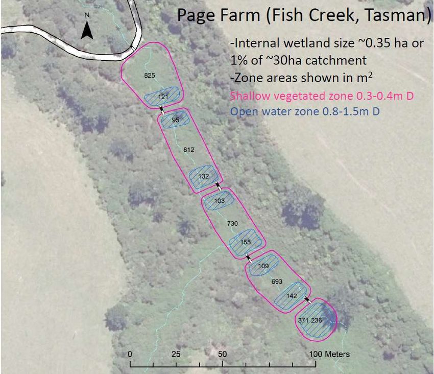
Contents
Executive summary ............................................................................................................. 5
1 Introduction .............................................................................................................. 8
1.1 Scope......................................................................................................................... 8
1.2 Approach................................................................................................................... 9
1.3 Report outline ......................................................................................................... 10
2 Overview of mitigation types ................................................................................... 12
2.1 Constructed wetland .............................................................................................. 12
2.2 Denitrification bioreactor ....................................................................................... 13
2.3 Detainment bunds .................................................................................................. 14
2.4 Riparian buffers ...................................................................................................... 15
3 Regulatory requirements ......................................................................................... 16
3.1 Activity status.......................................................................................................... 16
3.2 Key terms ................................................................................................................ 17
3.3 Rules for different activities associated with farm-scale mitigations..................... 20
3.4 Synthesis ................................................................................................................. 30
4 Case study mitigations and regulatory requirements ................................................ 32
4.1 Te Ahuriri constructed wetland, Canterbury .......................................................... 32
4.2 Awatuna constructed wetland, Taranaki ................................................................ 36
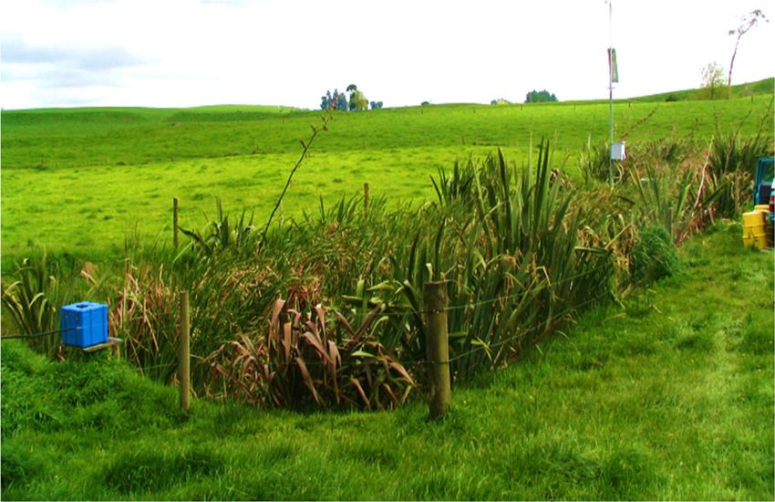
4.3 Page constructed wetland, Tasman........................................................................ 38
4.4 Permeable reactive barrier – Silverstream Reserve, Canterbury ........................... 39
4.5 Roberts Farm detention dam, Northland ............................................................... 42
4.6 Synthesis ................................................................................................................. 43
5 Incentives for installing edge-of-field, farm-scale mitigations .................................... 45
5.1 Financial incentives ................................................................................................. 45
5.2 Non-financial incentives ......................................................................................... 48
5.3 Additional comments.............................................................................................. 48
6 Discussion ............................................................................................................... 49
6.1 Regional differences ............................................................................................... 49
6.2 Specific planning provisions and guidance for mitigation measures ..................... 49
6.3 Core information needs for regulatory assessment ............................................... 51
6.4 Incentives for installing edge-of-field, farm-scale mitigations ............................... 53
Regulatory barriers to uptake of farm-scale diffuse pollution mitigation measures 3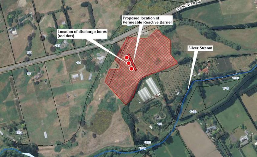
7    Conclusions ............................................................................................................. 54

8    Acknowledgements ................................................................................................. 56

9    References............................................................................................................... 57

Appendix A                 Regional Plan references .................................................................. 59

4                                  Regulatory barriers to uptake of farm-scale diffuse pollution mitigation measures
Executive summary
A growing number of mitigation initiatives are being explored and trialled across rural New Zealand
to reduce the impact of intensive land use on freshwater quality. Examples include planted riparian
buffers, constructed wetlands and woodchip denitrification filters. While the evidence base for the
technological efficacy of these mitigation initiatives continues to grow, a wide range of
social/behavioural, cultural, economic and regulatory barriers may limit their adoption by
landowners. Assessing some of these barriers forms part of the scope of the NIWA-led and MBIE-
funded “Doubling on-farm diffuse pollution mitigation” research programme on next generation
nutrient filter technologies.

In March 2019, NIWA partnered with DairyNZ to assess regional plan requirements likely to apply to
common mitigation initiatives intended to reduce farm-scale diffuse nutrient pollution. Landowners
may be reluctant to invest in these (and other) mitigation initiatives if the regulatory requirements
are uncertain, ambiguous, costly or overly constraining. At the request of DairyNZ, we also compiled
a summary of existing incentives (e.g., subsidies) available from regional councils to assist with
mitigation uptake.

Regulatory barriers
The scope of assessment was limited to a review of regional plan1 requirements relevant to the
construction, operation and maintenance of edge-of-field, farm-scale mitigation technologies. The
evaluation focussed primarily on the following edge-of-field mitigations: constructed wetlands,
seepage wetlands, riparian buffers, N-bioreactors, P-filters, detainment bunds, two-stage ditches,
bank re-battering, silt traps and in-channel remediation works (e.g., wood or woodchip addition).
Such mitigations generally involve activities – such as earthworks, stream diversions, stream bed
disturbance and discharges to land or water – that may trigger the need for resource consent(s) in
accordance with regional plans prepared under the Resource Management Act 1991. Activities such
as land disturbance may also trigger the requirement for consent(s) under other regulation, notably
city or district plans and the Building Act 2004. Requirements for consents under other regulation
were not reviewed in this report.

The review was desktop-based and involved summarising relevant permitted activity rules in regional
plans across New Zealand to identify the common conditions associated with these rules. Resource
consent applications and officer reports were reviewed for five mitigation projects, and face-to-face
meetings were also held with one or more regulatory and/or land/catchment management staff
across four councils to establish how rules were interpreted. Greater Wellington Regional Council,
Environment Canterbury, Waikato Regional Council and Bay of Plenty Regional Council were selected
as a subset of councils known to have had recent experience with the types of farm-scale diffuse
nutrient pollution mitigation measures addressed in this report.

We found that a very wide range of activities associated with the construction, operation and
maintenance of edge-of-field, mitigation measures could potentially trigger the requirement for
resource consent(s) under regional plan rules. These activities relate to the use of land
(e.g., earthworks to construct a wetland), disturbance of river (or lake) beds (e.g., for planting or
construction of a culvert or dam), the taking, use, damming or diversion of water, and the discharge
of contaminants to land or water (e.g., stormwater during earthworks or agrichemicals from
spraying). Although permitted activity rules exist for most of these activities, deposition of

1Including the relevant provisions of unitary plans or district plans of the six unitary councils (e.g., Auckland Council, Tasman District
Council) that have the responsibilities, duties and powers of a regional council. For the purposes of this report, these councils are referred
to as regional councils.

Regulatory barriers to uptake of farm-scale diffuse pollution mitigation measures                                                                5
woodchips into land and associated leachate discharges are not authorised by permitted activity
rules nor are, in many regions, construction of monitoring bores. Moreover, most permitted activity
rules are accompanied by lengthy lists of conditions. Failure to meet one or more of these conditions
will trigger the need for resource consent.

An important step is determining whether the proposed mitigation will interact with a river or
stream, as defined under the RMA (i.e., includes modified rivers and streams). By avoiding
construction in, or modification/disturbance of, the bed or banks of a river, stream, lake or natural
wetland, the likelihood that a resource consent will be required is reduced. The volume of
earthworks, dimensions of structures, timing of instream activities such as planting and construction
of structures, and the amount of water to be taken are also key factors in determining consent
requirements.

There is commonality across many of the standard conditions attached to permitted activity rules in
regional plans. The provision of fish passage and avoidance of works during fish spawning are almost
universal requirements across most permitted activity rules involving the disturbance of the beds of
rivers and lakes or the taking, using, damming or diversion of water. Other common conditions
include minimising the amount and effects of sediment release to surface water, avoiding or
remedying any erosion or scouring of stream banks, and avoiding impeding flood flows and flooding
of any neighbouring property.

When it comes to the more specific conditions of permitted activity rules, such as the maximum
upstream catchment areas and design criteria for construction of new structures (e.g., culverts and
dams), significant regional variation exists. Variation was also found with regard to the use and
definition of specific terms in plans. For example, some plans defined a drain while others referred to
a drainage canal, a farm drainage canal or a land drainage canal. In a few regions a modified river
was distinguished from a highly modified river, with the latter defined as one that had been
sufficiently modified and channelled to the extent that it has the characteristics of a drain.
Implementation of the recently introduced National Planning Standards will provide for greater
consistency in the definitions of many terms used in regional plans (and regional policy statements
and district plans), as well as greater consistency in plan structure and layout.

Examination of five recent edge-of-field diffuse pollution mitigation projects across four regions
indicated that it is difficult to meet many of the conditions associated with permitted activity rules. In
some cases, conditions were not met on technical grounds (e.g., a permitted activity rule for
disturbance of a riverbed did not authorise such disturbance for the purposes of wetland
construction) or there was no relevant permitted activity rule that applied to an activity
(e.g., depositing woodchips into land in a manner that may result in contaminants entering
groundwater). In three of the projects, the overall regional plan rule classification for the suite of
activities associated with the resource consent application defaulted to discretionary and, in one
project, non-complying. This occurred even though the mitigation projects had the primary or sole
purpose of environmental enhancement.

It is unlikely that implementation of many diffuse pollution mitigation measures could be catered for
through permitted (or even controlled) activity rules, particularly those located in or adjacent to
waterbodies. This is because the construction, operation and maintenance of most mitigations have
at least the potential to create short-term adverse effects that are easier to manage through more
restrictive classes of rules. Mitigation design and implementation must be customised to address
specific site and environmental requirements, making it more difficult to establish a single set of
standard conditions that could be applied to a permitted or controlled activity rule.

6                            Regulatory barriers to uptake of farm-scale diffuse pollution mitigation measures
Although it may be inevitable that a resource consent will be required to construct or implement a
mitigation in or near the beds of rivers and other natural waterbodies, it might be possible to
streamline the consenting process. New restricted discretionary rules that specifically target the suite
of activities associated with implementing mitigations could be developed as part of plan
change/review processes. Researchers and experienced practitioners could provide information to
assist policy makers with the development of these rules, including:
an overview of common mitigation measures, evidence of the scale and extent of their
environmental benefits, and any knowledge gaps around their performance, and
standard design requirements and recommended best management practices to
avoid, remedy or mitigate potential adverse effects associated with their construction,
operation and maintenance.
This information could also serve as guidance to assist council staff with their assessment of resource
consent applications, thereby further streamlining the consenting process.
Incentives
We assessed the incentives available to landowners to assist with implementation of farm-scale
diffuse pollution mitigation measures. After an initial review of regional council websites for relevant
funding or subsidy schemes we spoke to relevant staff at each council to identify or clarify eligibility
criteria, application requirements and the application process. We met with staff where visits were
scheduled with councils to discuss regulatory barriers. We were also given access to email responses
to an informal and independent survey of regional council grants and funding undertaken through
the regional sector’s Land Managers Special Interest Group in mid-2019.
All but one regional council made financial grants or other funds available for environmental
enhancement projects, including implementation of diffuse pollution mitigation measures. Although
riparian planting and fencing remain the most commonly funded activities, almost half of the
councils made available financial or other support (e.g., provision of free or subsidised plants,
assistance with consenting and monitoring) for a wider suite of initiatives specifically intended to
improve water quality. Further, while some councils have traditionally engaged with any landowner
or group interested in environmental enhancement, in some regions funding of projects in
catchments with degraded or declining water quality is now prioritised, alongside biodiversity
enhancement or protection. Implementation of the National Policy Statement for Freshwater
Management, notably the requirement to maintain or improve freshwater, is a key driver behind
this, as evidenced by Bay of Plenty Regional Council establishing a new Environmental Programme
Grants Policy in 2019.
The availability of regional council funding and assistance to landowners interested in mitigation
projects varies from region to region, along with the eligibility criteria and application process. Some
of this information is not easy to locate on council websites and staff from several councils indicated
a degree of flexibility exists with regard to assessing mitigation projects. It is therefore in the interest
of the landowner to contact the council – probably a land or catchment management officer in the
first instance – to discuss their individual situation and to identify what type(s) of funding and other
assistance may be available.
Regulatory barriers to uptake of farm-scale diffuse pollution mitigation measures 7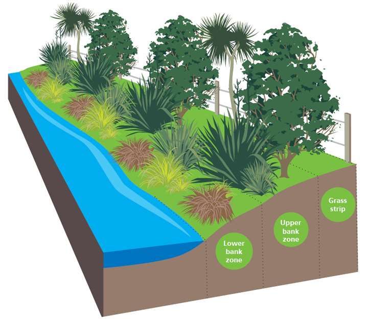
1 Introduction
A growing number of mitigation tools are being explored and trialled across rural New Zealand to
reduce the impact of intensive land use on freshwater quality. Examples include planted riparian
buffers, constructed wetlands, and woodchip denitrification filters. While the evidence base for the
technological efficacy of these mitigation initiatives continues to grow, a wide range of
social/behavioural, cultural, economic and regulatory barriers may limit their potential adoption by
landowners. Understanding some of these barriers forms part of the scope of the NIWA-led and
MBIE-funded “Doubling on-farm diffuse pollution mitigation” research programme on next
generation nutrient filter technologies.
1.1 Scope
In March 2019, NIWA partnered with DairyNZ to assess regional plan requirements that apply to
common mitigation initiatives designed to reduce diffuse nutrient pollution at the farm-scale.
Landowners may be reluctant to invest in these (and other) mitigation initiatives if the regulatory
requirements are uncertain, ambiguous, costly or overly constraining. At the request of DairyNZ, we
also compiled a summary of existing incentives (e.g., subsidies) available from regional councils to
assist with mitigation uptake.
The project was limited to a review of regional plan2 requirements relevant to the construction,
operation and maintenance of edge-of-field, farm-scale mitigation technologies, particularly when
sited close to or within waterways and drains. The evaluation considered the following edge-of-field
mitigations: constructed wetlands, seepage wetlands, riparian buffers, N-bioreactors, P-filters,
detainment bunds, two-stage ditches, bank re-battering, silt traps and in-channel remediation works
(e.g., wood or woodchip addition). Implementation of such mitigations generally involves activities
such as earthworks, stream diversions, stream bed disturbance, and discharges to land or water.
These activities may trigger the need for resource consents in accordance with regional plans
prepared under the Resource Management Act 1991 (RMA). Some of these activities, particularly
land disturbance and construction of structures such as dams, may also trigger the requirement for
consents under other regulation, notably city or district plans and the Building Act 2004. The
requirement for consents under other regulation is not reviewed here.
In accordance with the project brief, this review has considered:
The types of resource consents required (e.g., land use permit to dam or reclaim,
water permit to take or divert from a water body, discharge permit to discharge
contaminants to land or water), including any variation in regional plan rule
requirements:
− according to whether a watercourse is natural, modified or artificial (and where
possible, how councils determine the watercourse ‘status’),
− arising from the proximity of mitigation measures to a water body, including
instream vs out of stream, and
− related to the dimensions of structures (e.g., dam wall heights, impoundment
volumes or catchment areas, wetland surface area/volume).
2Including the relevant provisions of unitary plans or district plans of the six unitary councils (e.g., Auckland Council, Tasman District
Council) that have the responsibilities, duties and powers of a regional council. For the purposes of this report, these councils are referred
to as regional councils.
8 Regulatory barriers to uptake of farm-scale diffuse pollution mitigation measures
When fish passage would become an issue, and what sort of assessment of effects
might be required.
Existing council programmes that may assist with mitigation uptake, and the potential
for mitigation initiatives to act as an offsetting mechanism (e.g., credits in N budgets).
The core set of information needs, from a regional council perspective, that would
likely support a resource consent application(s).
1.2 Approach
1.2.1 Regulatory barriers
The review was desktop-based and involved tabulating a summary of relevant permitted activity
rules contained in regional plans across New Zealand, to identify the common conditions associated
with these rules. Conditions common to several regional plans may signal areas where particular
attention will be needed when developing guidance to assist with policy development or consenting.
Resource consent applications and officer reports were then reviewed for five mitigation projects to
identify which specific activities triggered a requirement for a resource consent. Face-to-face
meetings were also held with one or more regulatory and/or land/catchment management staff
across four councils to check interpretation of rules: Greater Wellington Regional Council,
Environment Canterbury, Waikato Regional Council and Bay of Plenty Regional Council. These
councils were selected as a subset of those that were known to have had recent experience with the
types of farm-scale diffuse nutrient pollution mitigation measures considered in this report.
1.2.2 Incentives
The assessment involved an initial review of regional council websites to identify potentially relevant
funding or subsidy schemes, followed by telephone calls to each council to identify or clarify
eligibility criteria, application requirements and the application assessment process. In most cases,
calls were made to a council land management officer. Opportunities to speak with staff face to face
were taken where visits were scheduled with councils to discuss regulatory barriers. In addition,
following a meeting with land management staff at Bay of Plenty Regional Council in September
2019, we were provided with a suite of individual council email responses on incentives canvassed
via the regional sector’s Land Managers Special Interest Group (this was undertaken independently
of this project).
1.2.3 Caveats and limitations
Although the review of regional plans focused primarily on rules rather than objectives
and policies, all components are applicable when evaluating some proposed activities
(e.g., one that triggers a non-complying rule, see Figure 3-1).
Many regions are in the process of updating their regional plans to give effect to
‘rolling’ amendments to the National Policy Statement for Freshwater Management
(NPS-FM) and the requirements of other recently introduced national legislation. As a
result, the status of plans across councils varies from draft to proposed to fully
operative, with some regions operating under parts of existing (generally ‘dated’) plans
as well as parts of proposed plans. A pragmatic approach was taken to focus on
capturing the most recent thinking around rules, even if the plan was not yet operative
(i.e., preference was given to review of draft and proposed plans rather than dated
existing plans).
Regulatory barriers to uptake of farm-scale diffuse pollution mitigation measures 9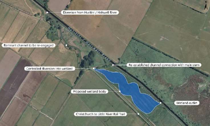
Rules in five regional plans were reviewed between March and May 2019, with the
remaining 11 plans reviewed in March 2020. Due to the highly evolving nature of
current regional planning, details of some rules have already changed (e.g., following
the release of decisions on Greater Wellington Regional Council’s Proposed Natural
Resources Plan in July 2019). With a new draft NPS-FM and a new Proposed National
Environmental Standard for Freshwater Management released for consultation in
September 2019, more changes to plan rules will follow. It was beyond the scope of
this report to evaluate changes made in response to very recently released draft and
proposed national regulations.
The structure and content of regional plans vary across regions, with potentially large
numbers of rules to check and cross reference. The assessment of permitted activity
rules in Section 3 is therefore intended to be indicative, rather than definitive or
exhaustive, of the rules most relevant to implementing diffuse pollution mitigation
measures.
Many regional plans now contain both region-wide and sub-regional (catchment-
specific) provisions, with potentially up to 10 sub-regional plans at various stages of
preparation (e.g., the Canterbury region is divided into 10 zones). For the purposes of
this exercise, it was not possible or necessary to review all sub-regional plan rules; the
types of activities involved with the construction, operation and maintenance of edge-
of-field, farm-scale mitigation technologies tend to be addressed under regionwide
plan rules. In reality, if a resource consent was being applied for, the provisions of any
relevant sub-regional plan would need to be reviewed to check for additional or
specific location-based restrictions or caveats on activities.
As noted in Section 1.1, there is regulation beyond regional plans that should be
checked when considering implementation of edge-of-field, farm-scale mitigation
technologies. Examples include district plans, the Building Act 2004 and the Freshwater
Fisheries Regulations 1983.
The discussions held with regional council staff helped to clarify both regulatory
barriers and council incentives, but were not in-depth and do not constitute formal
council advice for adoption or consenting of specific mitigation measures. As our
review of incentives was limited to readily accessible information, it is possible that
additional financial or other incentives may exist to those summarised in Section 5.
1.3 Report outline
This report comprises seven sections:
Section 2 briefly outlines several common edge-of-field, farm-scale mitigation
measures to set the scene for the types of activities associated with their construction,
operation and maintenance that might require resource consent (Section 3).
Section 3 summarises the findings from the assessment of regional plan permitted
activity rules for common activities associated with the the construction, operation
and maintenance of mitigations. It includes an overview of definitions in the RMA and
various regional plans that are critical when determining the applicability of regional
plan rules.
10 Regulatory barriers to uptake of farm-scale diffuse pollution mitigation measures Section 4 outlines five recently consented mitigation projects, including the specific
activities that triggered the requirement for a resource consent.
Section 5 summarises our collation of existing incentives offered by regional councils
that might assist with uptake of edge-of-field, farm-scale mitigation measures.
Section 6 discusses the key findings from Sections 3 to 5 and makes a case for the
development of specific planning provisions and guidance for mitigation measures.
Key information required to support a resource consent application is also
summarised.
Section 7 presents conclusions drawn from the project findings.
Regulatory barriers to uptake of farm-scale diffuse pollution mitigation measures 112 Overview of mitigation types In this section we briefly outline several edge-of-field and farm-scale mitigation measures; constructed wetlands, denitrification bioreactors, detainment bunds and riparian buffers. This overview sets the scene for the types of activities associated with their construction, operation and maintenance that might require resource consent (Section 3). 2.1 Constructed wetland A constructed wetland (CW) is a treatment system that uses natural processes involving wetland vegetation, soils, and their associated microbial assemblages to improve water quality. In the context of this report a CW is an artificial wetland designed to remove sediment and nutrients from agricultural runoff or drainage water that is passed through them. Section 4 of this report includes examples of constructed surface-flow wetlands which comprise shallow channels planted with tall emergent wetland plants (Figures 2-1 and 2-2). These types of wetland remove nitrate-nitrogen (N) through microbial denitrification, supplemented by plant uptake and accretion in sediments. Denitrification is promoted by close contact with organic sediments and wetland plants that provide anoxic conditions and organic matter (e.g., through decomposing plant litter) for denitrifying microbes. Anoxic conditions can also be created or maintained through the addition of other organic material such as woodchips or sawdust (Tanner et al. 2020). Surface-flow wetlands also remove phosphorus (P), principally particulate-associated P, primarily through settling in deeper and vegetated parts of the wetland (Tanner et al. 2020). Phosphorus removal can also be promoted using P-sorbing media, including iron- and calcium-rich materials (Ballantine and Tanner 2010), although these materials generally have a finite life and will need to be replaced when saturated. Wetlands can be constructed off-line or in-stream and generally require significant earthworks. Off- line wetlands generally only intercept a proportion of the flow, and so receive and remove less contaminant (Tanner et al. 2020, Woodward et al. 2020). Figure 2-1: Cross section schematic of a surface-flow constructed wetland.Source: Tanner et al. (2010). 12 Regulatory barriers to uptake of farm-scale diffuse pollution mitigation measures
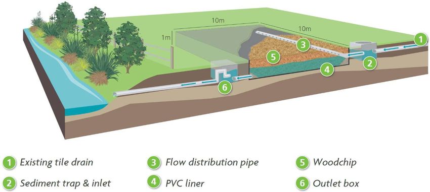
Figure 2-2: Small scale constructed wetland intercepting tile drainage on a Waikato Dairy Farm.Photo: Chris
Tanner (NIWA).

2.2     Denitrification bioreactor
A denitrification bioreactor is a woodchip denitrification wall or a denitrifying permeable reactive
barrier (PRB) but also goes by other names; woodchip bioreactor, denitrifying wall, bioreactor wall,
denitrifying bed, and bioreactor bed. These technologies involve placing woodchips or other solid
porous organic substrate within the ground below the water table or in a surface water body such as
a farm drain. They can also be used to treat subsurface drainage (e.g., tile or mole drains). The
organic material provides organic carbon, which stimulates microbial activity that in turn removes
nitrate from groundwater or surface water passing through the wall. Similar to constructed wetlands,
bioreactors operate under anoxic conditions, favourable to the conversion of nitrate to nitrogen gas.
An example of a PRB inserted in a shallow gravel aquifer system is shown Figure 2-3 and outlined as a
case study in Section 4.4.

Figure 2-3: Cross section schematic illustrating how a subsurface PBR intercepts and treats nitrate in
groundwater.Source: Farmers Weekly (2017).

Regulatory barriers to uptake of farm-scale diffuse pollution mitigation measures                         13
Bioreactors can be installed either in-line (within a drain, Figure 2-4) or off-line (water is diverted into
the bioreactor via an offtake). Inlet and outlet structures are required, with excess flow bypassed. A
sediment trap is also required upstream to prevent clogging of the bioreactor bed (Schipper et al.
2010).

Over time the performance of a bioreactor performance will decline. The expected life is 10-20 years
depending on the location and the type of carbon source. After this time the carbon source will need
to be added to or replaced (Schipper et al. 2010).

Figure 2-4: In-line bioreactor bed.Source: Tanner et al. (2010).

2.3     Detainment bunds
A detainment bund (DB) is a low (~2 m high) earthen dam with a decanting outlet control. It is
constructed to intercept and temporarily hold large quantities of surface runoff from pasture (Levine
et al. 2019, Figure 2-5). A DB essentially operates as a sedimentation basin; it works by slowing the
velocity of the runoff water, allowing time (~3 days) for fine sediment particles to settle, along with
attached P.

Figure 2-5: Sediment detention bund schematic.Image courtesy of John Paterson (Bay of Plenty Regional
Council).

14                             Regulatory barriers to uptake of farm-scale diffuse pollution mitigation measures
Numerous DBs are in place in the Lake Rotorua catchment. While initially installed to target sediment
and particulate P, research has now extended to the capture of dissolved reactive P (DRP). Two
approaches are relevant: natural retention of DRP by adherence to sediment whilst held in the DB
pond, and enhanced detention following treatment of the pond inflow with a non-toxic flocculant
(Dorner et al. 2018). The second approach is still to be assessed in a field-trial.

Detainment bunds require earthworks to create the excavated settling pond/storage area. However,
unlike sediment traps which target coarser sediment particles, desilting of the DB to remove
accumulated sediment is only infrequent required.

2.4     Riparian buffers
Riparian buffers are vegetated “buffer strips” commonly used to stabilise stream banks and capture
and filter sediment, nutrients and other contaminants moving in overland and subsurface flow
(Figure 2-6). Riparian buffers can also remove nutrients in shallow groundwater via assimilation in
the root zone and denitrification. In addition to improving water quality of adjacent waterbodies,
buffer strips provide multiple other benefits (e.g., habitat and shade, increased biodiversity, wildlife
corridors).

Figure 2-6: Schematic of a riparian buffer, illustrating three different zones.Image from DairyNZ website
(https://www.dairynz.co.nz/environment/waterways/planting-waterways/ accessed 20 May 2019).

Regulatory barriers to uptake of farm-scale diffuse pollution mitigation measures                           15
3 Regulatory requirements
The edge-of-field, farm-scale mitigation measures outlined in Section 2 involve one or more activities
(e.g., excavation of land, diversion of water) that may require resource consent from regional
councils under Sections 9, 13, 14 and 15 in Part 3 of the RMA:
Section 9: Restrictions on the use of land
Section 13: Restrictions on certain uses of beds of lakes and rivers
Section 14: Restrictions relating to the taking, using, damming or diversion of water
Section 15: Discharge of contaminants
Consent requirements are determined by examining the relevant regional plan(s) to verify the status
of the activity. This section summarises the provisions of relevant regional plan permitted activity
rules and associated conditions. If the permitted activity conditions can’t be met, a resource consent
will be required.
3.1 Activity status
Sections 77A and 87A of the RMA provide for six different classes (status) of activity (Figure 3-1). The
rules in a Regional Plan determine the status of a particular activity such as discharging drainage
water into another waterbody or constructing a culvert. Many of the activity classes are subject to
associated conditions, permissions or requirements that must be met in order for that activity status
to apply.
As outlined in Section 3.3, although many of the activities associated with farm-scale mitigations
potentially qualify as permitted activities, generally multiple conditions must be satisfied. If this is not
possible, the activity status defaults to one that requires resource consent (e.g., a controlled or
discretionary activity). Moreover, as illustrated in Section 4, where multiple resource consents are
required for a mitigation proposal to proceed, the activities tend to be ‘bundled’ into one application
with the most restrictive activity classification applied to the overall proposal. This highlights the
importance of understanding and, where possible, working within the constraints of permitted
activity rules.
Permitted Controlled Restricted Discretionary Non-complying Prohibited
Discretionary
Resource consent Resource consent is
Resource consent is
is required and Resource consent is required and can only
required and the
always granted required and the be granted if the
No resource Council has restricted No resource
with the Council Council has retained consent application
consent is the exercise of its to consent will
limiting its control its discretion as to meets RMA threshold
required grant to a range of be granted
to matters whether it will grant criteria and the
matters listed as part
specified as part of resource consent objectives and policies
of the relevant rule
the rule of the Regional Plan
Figure 3-1: Summary of the different classes (status) of activity under the RMA and addressed in regional
plans.
16 Regulatory barriers to uptake of farm-scale diffuse pollution mitigation measures3.2 Key terms
Many rules in regional plans contain key terms with associated definitions. These definitions must be
checked when assessing whether a proposed activity complies with a particular rule. For example, it
may be a permitted activity to discharge drainage water into an artificial watercourse but not into a
stream. In this instance, it is necessary to check what is meant by “drainage water”, “artificial
watercourse” and “stream”. Although some terms – such as water and river – are defined under the
RMA, there are currently few universal definitions that are used across all regional plans. Each
regional plan needs to be checked on a case-by-case basis to interpret rules for various activities.
Table 3-1 summarises some key terms relevant to assessing the status of activities associated with
the construction, operation and maintenance of common edge-of-field mitigations. Across the 16
Regional Plans that were reviewed, just seven defined a drain, with most (10) defining an artificial
watercourse and seven defining a modified watercourse or a highly modified watercourse.
Intermittent and ephemeral (watercourses) were defined in six and seven plans, respectively.3 Bay of
Plenty’s Regional Natural Resources Plan (RNRP) contained the most terms relating to drains and
different types of watercourses, and was one of seven regional plans to differentiate between a
modified and an artificial watercourse. The RNRP also contained a comprehensive description of
what does and does not constitute a wetland, accompanied by photographs and a useful diagram
(Figure 3-2) that illustrates what constitutes a wetland on land vs a wetland on the bed of a river or
lake; this is important because, as illustrated in Section 4, construction of the latter will nearly always
require a resource consent.
Figure 3-2: Illustration of a wetland on land vs a wetland on the bed of a river or lake.Reproduced from Bay of
Plenty Regional Council's Regional Natural Resources Plan.
Although the definitions for common terms vary between regional plans, a modified watercourse is
consistently differentiated from an artificial watercourse and a drain by being defined as a river or
stream that has undergone some form of modification (e.g., channel straightening). This is (required
to be) consistent with the definition of a river under the RMA:
“A continually or intermittently flowing body of fresh water; and includes a stream and modified
watercourse; but does not include any artificial watercourse (including an irrigation canal, water
supply race, canal for the supply of water for electricity power generation, and farm drainage
canal).”
3Note that some regional plans defined terms indirectly via the definition of a related term. For example, Taranaki Regional Council’s Draft
Soil and Water Plan defines a drain as any artificial watercourse and includes references to different types of drains. Similarly, the RMA’s
definition of a river also include reference to intermittent rivers.
Regulatory barriers to uptake of farm-scale diffuse pollution mitigation measures 17Table 3-1: Selected terms defined in various regional plans of relevance when assessing the status of activities associated with the construction, operation and maintenance of
edge-of-field, farm-scale diffuse source pollution mitigation measures. Excludes terms defined or referenced indirectly under other terms (e.g., in the RMA an intermittent river is
referred to within the definition of river). Refer to Appendix A for regional plan references.
Drainage Land Intermittent Riparian
Drainage Modified Artificial Water Ephemeral Vegetation
Drain / Land Drainage Watercourse River Bed Groundwater Bore Area /
Canal Watercourse Watercourse Race Stream Clearance
Drainage Scheme /River Margin
RMA
Northland RC
Auckland C 7
Waikato RC 1
Bay of Plenty RC 2
Gisborne DC
Hawke’s Bay RC
Taranaki RC 8
Horizons RC 6
Greater Wellington RC 5
Tasman DC 1
Nelson CC
Marlborough DC
West Coast DC 8
Environment Canterbury 4
Otago RC
Environment Southland
1
Farm Drainage Canal, 2 Land Drainage Canal, 3 Drainage system, 4 Drainage channel, 5 Highly modified river or stream, 6 Active bed, 7 Vegetation alteration or removal,8 Vegetation disturbance.
18 Regulatory barriers to uptake of farm-scale diffuse pollution mitigation measuresAn artificial watercourse has a wider definition than a drain in regional plans and tends to cover one
or more of man-made channels, irrigation and drainage canals, water supply races, and roadside
drains (Figure 3-3). In contrast, a drain is typically defined as an artificial watercourse used for land
drainage purposes; it can be a surface drainage channel (Figure 3-3), an open race or sub-surface
pipe, a tile or mole drain, or a roadside drain.
Figure 3-3: Examples of watercourses that are not defined as a river under the RMA.Clockwise from top
left: An irrigation channel, a water supply race, an artificially constructed drain, an artificially constructed drain
lacking surface flow, a hydro canal and a farm drain. Photos: Otago Regional Council4.
Determining if a waterway is a river or stream may require a discussion with the relevant regional
council. The factors the council will consider generally include:
If the watercourse is shown on a topographical map,
If the source of the water course is from hills/ranges, etc.,
If the watercourse has a defined bed or pathway,
If the watercourse is in an original natural channel,
Whether or not water flows all or part of the time,
If the watercourse is ‘named’ or goes by a local name,
If the watercourse supports aquatic life, and
If there are historic structures (e.g., bridge) over the watercourse.
Most of the regional plans define a riparian area (or riparian margin) and what constitutes
vegetation clearance (Table 3-1).
4 What is a river guide sheet 05112015, accessed 20 May 2019 from: https://www.orc.govt.nz/media/4408/what-is-a-river.pdf
Regulatory barriers to uptake of farm-scale diffuse pollution mitigation measures 193.3 Rules for different activities associated with farm-scale mitigations
This section outlines regional plan permitted activity rule requirements relevant to common activities
associated with edge-of-field, farm-scale mitigations. Activities have been grouped as follows:
Earthworks, vegetation clearance and soil disturbance,
Plant introduction and removal,
Channel realignment, deepening, widening or cleaning,
Construction and use of culverts and intake and discharge structures,
Taking/diverting or discharge of water,
Dams and damming water, and
Discharge of contaminants to land and water.
Brief commentary is also provided on the establishment of monitoring bores and monitoring stations
owing to the significant research and monitoring requirements associated with many newly
established or proposed edge-of-field mitigations.
The above list of activities is not considered in relation to natural wetlands because, with the possible
exception of specific types of planting and monitoring structures, they are not provided for under
permitted activity rules.
3.3.1 General permitted activity conditions
Activities such as construction of culverts, drain maintenance and the introduction or removal of
instream plants usually involve disturbance of the bed of a river, stream or artificial waterway. Many
regional plans contain a set of general conditions that apply to all bed disturbance activities as well as
further conditions that relate to the specific activity. For example, the Horizons One Plan permitted
activity rule for planting comprises five conditions, one of which is that the activity must meet the
general conditions listed in Section 17.3 of the Plan. Some of the conditions summarised in Tables 3-2
to 3-4 frequently appear as general conditions (e.g., maintenance of fish passage). Note that not all
of the general conditions have been included in these tables (e.g., avoiding disturbance of
archaeological or waahi tapu sites).
Where activities occur in or near waterways specified in a regional plan as being managed for flood
protection purposes, additional bylaws (e.g., Canterbury Regional Council Flood Protection and
Drainage Bylaw 2013) or conditions may apply (e.g., prior approvals or notification from the relevant
council scheme operator, seasonal restrictions).
3.3.2 Earthworks, vegetation clearance and soil disturbance
Most regional plans make provision for small-scale earthworks, vegetation clearance and soil
disturbance as permitted activities near waterways in ‘low risk’ areas (e.g., on stable land). Table 3-2
indicates that conditions placed on permitted activity rules often restrict the area of land or volume
of earthworks that can occur within the riparian margin, with the specified area or volume varying
between regions. Minimum setback distances often also apply to vegetation clearance (e.g., 5 m in
Hawke’s Bay region for any permanently flowing river or any other river over 2 m wide), with the
distance varying in some regions depending on location (e.g., whether inside an area of high soil
erosion risk) and land slope. Common general conditions require any direct discharges of sediment to
water to be avoided, and that no significant change in water colour or clarity exists after reasonable
mixing, or that instability, subsidence or erosion of land does not occur as a result of the activity.
20 Regulatory barriers to uptake of farm-scale diffuse pollution mitigation measuresTable 3-2: Summary of typical permitted activity conditions in regional plans relating to earthworks, vegetation clearance (excluding forestry) and soil disturbance
undertaken in close proximity to surface waterbodies (excluding natural wetlands).Not every PA condition is listed. Refer to Appendix A for regional plan references.
Conditions to be satisfied
Region
No resulting land
Specific restrictions on area of land or Minimum setback distance Vegetation/soil No resulting significant change in Site stabilisation
instability,
volume of earthworks within the from streams for vegetation prevented from colour/clarity of adjacent water body upon completion of
subsidence or
riparian margin clearance entering surface water (or other s107 effects) works
erosion
Northland 200 m2 exposed earth 10 m
Auckland 1,000 m2 20 m
Soil disturbance and vegetation clearance are not provided for as a
Waikato Suspended sediment criteria apply Within 6-12 months
permitted activity in any ‘high risk erosion area’
5-25 m, depending on land
Bay of Plenty Max. exposed land area 400 m2 a Within 3 months
slope & location
Gisborne
Hawke’s Bay 5m Within 18 months
Taranaki < 8 ha, 24,000 m3 soil disturbance Within 6 months
Manawatu- (2,500 m2 earthworks per property per
5m
Whanganui 12-month period)
(3,000 m2 earthworks per property per
Wellington Within 6 months
12-month period)
10-20 m depending on land
Tasman Within 12 months
slope and vegetation type b
Nelson 5m Within 6 months
Marlborough 1,000 m2 per 24-month period 8m Within 24 months
West Coast 25 m3
Canterbury 500 m2 or 10% of the area 5m Suspended sediment criteria apply
Otago No relevant permitted activity rules exist
Southland No relevant permitted activity rules exist
a 10 m for designated wetlands, trout spawning sites and other sites of significance. For streams >3 m average bed width.
b
Regulatory barriers to uptake of farm-scale diffuse pollution mitigation measures 21Environment Canterbury’s Land and Water Regional Plan (LWRP) has a specific permitted activity rule
for earthworks undertaken over aquifers. This rule requires:
over coastal confined aquifer systems – more than 1 m of undisturbed material
between the deepest part of the excavation and the first aquifer, with a setback
distance of 50 m from any surface waterbody where more than 100 m3 of material is
to be excavated, and
over unconfined and semi-confined aquifers – a maximum of 100 m3 of material to be
excavated unless there is more than 1 m of undisturbed material between the deepest
part of the excavation and the seasonal high water table level and the distance from
any surface waterbody is at least 50 m.
We did not identify any relevant permitted activity rules for earthworks or vegetation clearance in
regional plans for Otago or Southland.
3.3.3 Stream or drain channel realignment, deepening, widening or cleaning
Channel realignment, deepening or widening and removal of bed material (e.g., sediment) as part of
channel maintenance are generally only provided for as permitted activities in artificial watercourses
such as drains. A few regions (e.g., Wellington, Southland) extend permitted activity status to include
maintenance activities in modified or highly modified rivers – which are essentially defined as those
that have been modified and channelled to the extent that they have the characteristics (in form or
function) of an artificial farm drainage canal.
The standard conditions associated with permitted activity rules for alteration or maintenance of
drains are similar to those listed for other activities that involve bed disturbance. Conditions include,
for example:
minimising the amount and effects of sediment release,
no resulting erosion or scour of the banks, or flooding of any neighbouring property,
seasonal restrictions on the timing of works (e.g., to avoid fish spawning), and
maintenance of fish passage.
Environment Southland’s Proposed Water and Land Plan also requires all reasonable steps to be
taken to immediately return to water any fish captured or stranded by the maintenance activity. This
is consistent with the Freshwater Fisheries Regulations 1983 which require that fish be immediately
returned to a waterbody if they are removed incidentally or intentionally by activities such as the
cleaning of drains.
3.3.4 Culverts and intake/discharge structures
Most regional plans make provision for the use, installation or alteration of a culvert – including the
associated disturbance of the bed of a lake or river (and therefore any sediment discharge or deposit
of materials related with construction) and take, discharge or diversion of water – as a permitted
activity subject to various conditions. The conditions vary across regional plans (Table 3-3) but tend
to relate to:
avoiding waterbodies in designated schedules (e.g., sites of ecological significance,
designated trout/salmon spawning site),
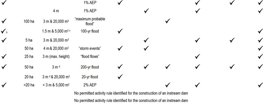
22 Regulatory barriers to uptake of farm-scale diffuse pollution mitigation measuresTable 3-3: Summary of typical permitted activity (PA) conditions in regional plans relating to the use, erection, alteration of a culvert in, on over the bed of rivers, lakes and
artificial watercourses.In most cases this activity also permits any associated bed disturbance, discharge of water or sediment, water diversion and deposit of substances in/on
the bed. Not every PA condition is listed. AEP = annual exceedance probability. Refer to Appendix A for regional plan references.
Conditions to be satisfied
Region Sediment-related
Max. Not in a Culvert Seasonal restrictions on Maintain
Location Flood event Other design- No increase in erosion discharge or receiving
upstream permanently dimensions construction (e.g., during fish
restrictions design criteria related criteria or flooding water standards to be
catchment flowing stream apply inanga or trout spawning) passage
met
Northland 300 ha 1% AEP
Auckland 10% AEP (narrative)
2% AEP unless
Waikato 100 ha
spillway
Bay of Plenty
Gisborne 20% AEP (narrative)
Hawke’s Bay 150 ha
Taranaki (narrative)
Manawatu- 5% AEP unless
Whanganui spillway
Wellington 5% AEP
Tasman 2% AEP
Nelson 10 ha 2% AEP (narrative)
Secondary
Marlborough
flow path
West Coast (narrative)
Canterbury 5% AEP
Otago
Southland (narrative)
Regulatory barriers to uptake of farm-scale diffuse pollution mitigation measures 23 a maximum upstream catchment area that must not be exceeded (e.g., 100 ha in
Waikato),
maximum dimensions of the culvert,
a design for a minimum-sized flood event (e.g., 1 in 50 year) that avoids any increase in
upstream water levels which causes flooding on neighbouring properties,
a minimum set-back distance from a dam, weir, bridge, network utility pole, defence
against water, etc.,
avoiding works in flowing water,
avoiding excess release of sediment – often with associated instream visual clarity or
suspended sediment criteria,
the erection or placement of the culvert not causing any downstream erosion, scour or
sediment deposition,
avoiding works during designated fish spawning periods (e.g., May to September in
Hawke’s Bay), and
maintaining existing fish passage both upstream and downstream of the culvert or
intake/discharge structure.
Some regional plans contain additional requirements for culvert design or construction. For example,
Environment Canterbury’s LWRP requires that excavated areas are left with battered slopes not
steeper than a 3:1 slope angle.
The erection and use of intake and/or discharge structures is generally provided for as a permitted
activity. The conditions associated with the permitted activity rule are similar to those that apply to
culverts.
3.3.5 Plant introduction and removal
Most regional plans permit plant introduction or disturbance of the beds of rivers or lakes without
requiring a resource consent. Table 3-4 summarises some of the relevant permitted activity
conditions where plants are introduced into, or removed from, the beds of rivers or lakes. Almost all
plans restrict the type or species of plants that can be planted (notably pest plants). Seasonal
restrictions are also common conditions, particularly with regard to plant removal, which has to
occur outside of common fish spawning or migration periods. In rivers with specified fish values, this
limits the window of time available to undertake works to just a few months of the year (e.g.,
November to February in the Bay of Plenty region).
Many plans seek to protect existing indigenous flora and some also promote new plantings of such
flora for the specific purpose of environmental enhancement. For example, permitted activity rule 83
in Taranaki Regional Council’s Draft Soil and Water Plan promotes planting or removal of existing
vegetation or debris for environmental enhancement purposes.
Other conditions associated with permitted activity rules for plant introduction or removal are
standard conditions commonly listed for any activities that involve bed disturbance (e.g., no
significant erosion or scour of stream banks, maintenance of fish passage).
24 Regulatory barriers to uptake of farm-scale diffuse pollution mitigation measuresYou can also read