Proposed Development Scheme - Caloundra South Urban Development Area - For consultation - not government policy
←
→
Page content transcription
If your browser does not render page correctly, please read the page content below
For consultation - not government policy

                                                           Caloundra South
                                                    Urban Development Area
                                           Proposed Development Scheme

                                                                 April 2011
For consultation - not government policy
Contents

Caloundra South Urban Development Area Development Scheme

Introduction............................ 1   Introduction................................. 1                             3.3 UDA-wide criteria........................................... 8
                                                                                                                             3.3.1 Neighbourhoods.................................. 8
                                             1.1   The Urban Land Development Authority.......... 1
Strategic Context..................... 2     1.2   Urban Development Area................................ 1                   3.3.2 Centres............................................... 10
                                             1.3   Purpose of the development scheme.............. 1                          3.3.3 Housing diversity and affordability..... 10
Land Use Plan......................... 6     1.4   Elements of the development scheme............. 1                          3.3.4 Employment opportunities................. 11
                                             1.5   Acknowledgements......................................... 1                3.3.5 Movement network............................. 11
Infrastructure Plan............... 27
                                                                                                                              3.3.6 Greenspace network........................... 11
                                             Strategic Context.......................... 2
Implementation Strategy...... 32                                                                                              3.3.7 Community facilities........................... 12
                                             2.1 Background.................................................... 2
                                                                                                                              3.3.8 Natural values.................................... 12
Schedules.............................. 37   2.2 Vision............................................................. 2
                                                                                                                              3.3.9 Community safety and development
                                             Land Use Plan.............................. 6                                          constraints.......................................... 13
                                             3.1 Operation of the land use plan....................... 6                      3.3.10 Service infrastructure......................... 14
                                                 3.1.1 UDA development requirements......... 6                                3.3.11 General requirements......................... 14
                                                   3.1.2 Levels of assessment........................... 6               3.4 Zone provisions............................................. 20
                                                   3.1.3 Meaning of development..................... 6
                                                                                                                         Infrastructure Plan.................... 27
                                                   3.1.4 Schedules............................................ 6
                                                                                                                         Infrastructure Plan.............................................. 27
                                             3.2 Development assessment.............................. 7
                                                 3.2.1 Development consistent with the land                              Implementation Strategy........... 32
                                                       use plan............................................... 7
                                                                                                                         Implementation Strategy.................................... 32
                                                   3.2.2 Development approval........................ 7
                                                   3.2.3 Infrastructure agreements................... 7                  Schedules................................... 37
                                                   3.2.4 Consideration in principle.................... 7                Schedule 1: Exempt development....................... 37
                                                   3.2.5 Development application..................... 7                  Schedule 2: Definitions....................................... 39
                                                   3.2.6 Context plans....................................... 7          Schedule 3: Self-assessable provisions.............. 45
                                                   3.2.7 Plan of Development........................... 7
                                                   3.2.8 Notification requirements.................... 8
                                                   3.2.9 Interim use.......................................... 8
                                                   3.2.10 Relationship with local government
                                                          planning scheme and other legislation.8
                                                   3.2.11 Land not included in a zone................. 8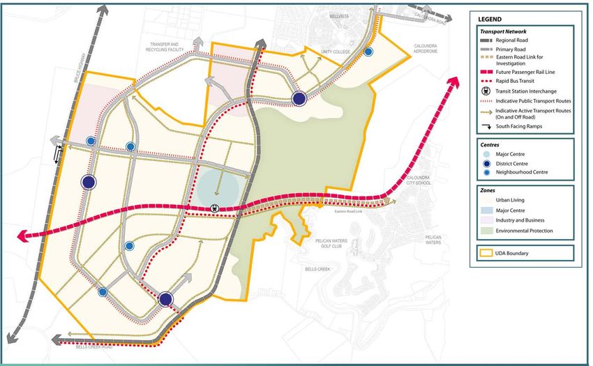
For consultation - not government policy
                                                                                                                                                     Introduction                             1.0

 1.1 The Urban Land                                1.2 Urban Development                           1.4 Elements of the                              1.5 Acknowledgements
     Development                                       Area                                            development scheme                           The scheme draws on the extensive planning
     Authority                                     The Caloundra South Urban Development           The scheme consists of:
                                                                                                                                                    work that has been undertaken in the
                                                                                                                                                    preparation of the Caloundra South Structure
                                                   Area (UDA) was declared by regulation on 22
 The Urban Land Development Authority                                                              ÈÈ a vision                                      Plan by Sunshine Coast Regional Council, in
                                                   October 2010.
 (ULDA) is a statutory authority under the                                                         ÈÈ a land use plan                               collaboration with the landowner and key
 Urban Land Development Authority Act
 2007 (the Act) and a key element of the
                                                   1.3 Purpose of the                              ÈÈ an infrastructure plan                        State agencies.

 Queensland Housing Affordability Strategy.            development scheme                          ÈÈ an implementation strategy.                   Prior to the declaration of Caloundra South,
                                                                                                   The vision for the UDA seeks to achieve the      Sunshine Coast Regional Council undertook
 The role of the ULDA is to facilitate:            The Caloundra South UDA Development                                                              public consultation on a draft Structure Plan
                                                   Scheme (the scheme) has been prepared in        purposes of the Act and provides the basis
 (i) the availability of land for urban purposes                                                   for the land use plan, infrastructure plan and   for Caloundra South. Submissions on the
                                                   accordance with the Act and is applicable                                                        draft Structure Plan have been considered in
 (ii) the provision of a range of housing          to all development on land within the           implementation strategy.
                                                                                                                                                    the preparation of the scheme.
      options to address diverse community         boundaries of the UDA. It is a statutory        Map 2 - Vision represents how Caloundra
      needs                                        instrument and has the force of law.            South may develop over time to meet the
 (iii) the provision of infrastructure for                                                         vision in the scheme.
                                                   The purpose of the scheme is to:
       urban purposes
                                                   ÈÈ establish the vision for the UDA             The land use plan regulates development
 (iv) planning principles that give effect                                                         and states the preferred form of development
      to ecological sustainability and best        ÈÈ regulate development to achieve the
                                                                                                   in the UDA.
      practice urban design                           vision
                                                   ÈÈ identify infrastructure and other            The infrastructure plan details the
 (v) the provision of an ongoing availability
                                                      strategies and mechanisms to achieve         infrastructure necessary to support the land
     of affordable housing options for low to
                                                      the vision.                                  use plan for the UDA.
     moderate income households.
                                                   From the date of approval under a regulation,   The implementation strategy describes other
 The ULDA works with local and state
                                                   the scheme replaces the Caloundra South         strategies and mechanisms that the ULDA
 governments, community, local landowners
                                                   Urban Development Area Interim Land Use         will use to complement the land use plan and
 and the development industry to deliver
                                                   Plan which commenced upon declaration.          infrastructure plan to achieve the outcomes
 commercially viable developments that
                                                                                                   for the UDA.
 include diverse, affordable, sustainable
 housing and use best-practice urban
 design principles.

                                                                                                                               Caloundra South Urban Development Area Proposed Development Scheme   1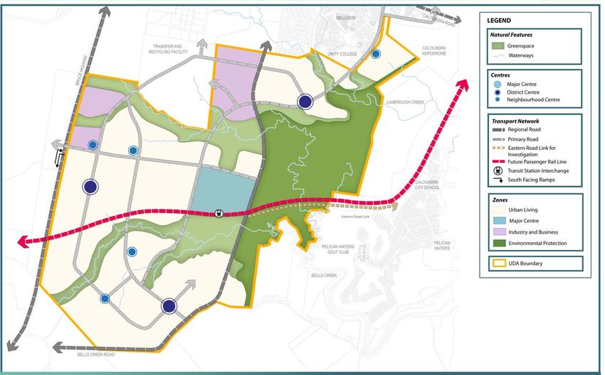
For consultation - not government policy
    2.0           Strategic Context

     2.1 Background                                 in the Sunshine Coast local government area     Map 1: Caloundra South UDA boundary
                                                    by 2031. Caloundra South UDA provides an
     Caloundra South is located at the southern     opportunity to provide approximately 20,000
     limit of the Sunshine Coast Region,            dwellings to accommodate a population of                   1.   Caloundra Aerodrome
     immediately south of Caloundra. Caloundra      approximately 50,000 persons.                              2.   Lamerough Creek
     South UDA comprises approximately 2310                                                                    3.   Pelican Waters
                                                    While most of the UDA has been cleared for                 4    Bellvista                                              4
     hectares generally defined by:
                                                    previous land uses including forestry and                       Urban Development Area boundary
                                                                                                                                                                                            1
     ÈÈ Caloundra Aerodrome, Bellvista              grazing, stands of remnant vegetation remain                    Bruce Highway

        residential estate, the Sunshine Coast      in waterway corridors and some peripheral
        Regional Industrial Park and the northern   areas. Views south-west towards the Glass                                                                          2

        branch of Bells Creek in the north;         House Mountains are possible from the site.
     ÈÈ Caloundra Conservation Park, Bells          Pumicestone Passage is a significant
        Creek and the western edge of the           environmental feature within the Sunshine
        Golden Beach and Pelican Waters             Coast sub-region. Wetlands associated with
        neighbourhoods in the east;                 Pumicestone Passage, to the south east of
     ÈÈ Bells Creek Road in the south; and          the UDA, are recognised as being of national
     ÈÈ Bruce Highway in the west.                  and international significance.

     The UDA is characterised by a predominantly    The UDA is serviced by a number of existing
     flat to gently undulating topography which     and future regional transport linkages. The
     reflects its location on the margins of the    Bells Creek Road intersection on the Bruce

                                                                                                          AY
                                                                                                     HIGHW
     coastal plain. The land slopes generally       Highway provides opportunity for the future
     from west to east with a ridgeline along the   provision of an interchange to access the

                                                                                                    BRUCE
                                                                                                                                                                                   3

     southern boundary. The site is traversed       UDA and provide linkages to west of the
     by Lamerough Creek and the northern and        highway.
     southern arms of Bells Creek which all drain
     east to Pumicestone Passage.
                                                    2.2 Vision
     The South East Queensland Regional
     Plan 2009-2031 (Regional Plan)                 A vibrant community
     identifies Caloundra South as a Regional
     Development Area to be developed as a          ÈÈ Caloundra South provides attractive
                                                                                                                                     Bells Creek Road
     compact community supported by public             lifestyles for up to 50,000 residents and
     transport, housing choice and affordability,      approximately 15,000 jobs, in a variety of
     employment opportunities and facilities and       neighbourhoods, mixed-use centres and
     services. The Regional Plan identifies an         industrial areas.
     additional 98,000 dwellings will be required

2    Caloundra South Urban Development Area Proposed Development Scheme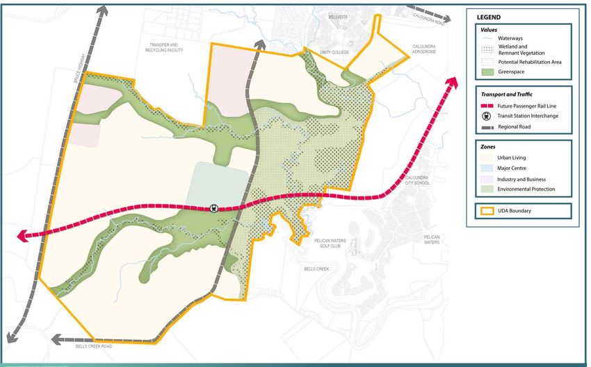
For consultation - not government policy
                                                                                                                                         Strategic Context                                     2.0

 ÈÈ Caloundra South is a significant              ÈÈ Residential uses, work from home             An accessible community                         A connected community
    community within the Sunshine Coast              opportunities and non-residential uses
                                                                                                  ÈÈ Caloundra South is a compact, well           ÈÈ Caloundra South is serviced by an
    and the South East Queensland region.            to serve the community needs will be
                                                                                                     planned community with higher density           integrated transport infrastructure
    It achieves the potential identified in the      provided within well designed, walkable
                                                                                                     residential development within and              network which supports transit oriented
    Regional Plan, providing a wide range            neighbourhoods.
                                                                                                     adjacent to centres and major transport         development, promotes pedestrian,
    of housing choices and employment             ÈÈ The natural contours and features               nodes to enhance accessibility to services      bicycle and public transport modes over
    opportunities, supported by community            provide an integrated and linked                and facilities, and reduce demand for           private vehicle use, provides for the
    services and a variety of transport modes.       greenspace network that provides safely         travel by private vehicle.                      integration between public transport
 ÈÈ Caloundra South is serviced by a network         linked nodes of open space to all parts of                                                      modes and connects Caloundra South to
                                                                                                  ÈÈ Caloundra South is serviced by an
    of centres, the major centre being the           the community.                                                                                  the sub-regional transport network.
                                                                                                     integrated public transport system that
    Caloundra South Major Regional Activity
                                                                                                     connects neighbourhoods and centres,         ÈÈ High quality and frequent public
    Centre (MRAC). The network of centres         An inclusive community
                                                                                                     linking with the future bus rapid transit       transport services are provided that
    within Caloundra South complements
                                                  ÈÈ Each neighbourhood provides a diversity         and rail service to provide good access to      connect Caloundra South to other
    the hierarchy of centres that supports
                                                     of housing, including affordable and            work, education and other opportunities         parts of the Sunshine Coast and the
    Maroochydore as the Principal Regional
                                                     accessible housing, to cater for a              elsewhere in the region.                        rail line that connects to Brisbane and
    Activity Centre and nearby Caloundra as
                                                     variety of households and changing           ÈÈ Caloundra South has been designed for           other destinations within South East
    a MRAC.
                                                     requirements as the community matures.          walking and cycling. It has a network           Queensland.
 ÈÈ The Caloundra South MRAC will
                                                  ÈÈ Caloundra South meets the social,               of pathways built around several major       ÈÈ The road network provides for convenient
    serve a sub-regional catchment and
                                                     community, recreational and                     off-road spines along the greenspace            movement for residents between their
    develop as a high quality town centre
                                                     entertainment needs of residents                corridors including Bells and Lamerough         homes, employment, recreation, leisure,
    providing a diverse range of retail,
                                                     through the provision of new services in        Creeks, and along major roads.                  retail and community facilities and takes
    business and commercial, civic, health,
                                                     accessible locations, including multi-          These spines are supplemented by a              account of the topography, natural
    community, educational, recreational and
                                                     purpose community facilities located in         comprehensive network of smaller links          vegetation and where possible views and
    entertainment facilities in conjunction
                                                     centres throughout the UDA.                     and safe, legible street layouts that link      vistas to the Glasshouse Mountains.
    with more intensive residential
                                                  ÈÈ There is a wide range of community              to and between centres, parkland and         ÈÈ The road network provides an efficient
    development. This will be supported by
                                                     groups catering for a variety of                other community facilities.                     system where the function of streets is
    district and neighbourhood centres that
    provide a focus for the community.               activities and interests, and providing                                                         clearly identified.
                                                     opportunities for life-long learning and                                                     ÈÈ A greenspace network will follow the
 ÈÈ Residents live in neighbourhoods which
                                                     recreation.                                                                                     Bells and Lamerough Creek systems.
    have a discernable identity and sense
    of place, and are designed around a           ÈÈ People have a multitude of opportunities                                                        The network includes an integrated
    community focal point which may be a             for social interaction in the centres                                                           pedestrian and cycle network linking
    local park or neighbourhood centre.              and parks that provide the focus for                                                            neighbourhoods, community facilities,
                                                     communities throughout Caloundra                                                                public transport nodes and places of
                                                     South.                                                                                          employment to the greenspace network.

                                                                                                                             Caloundra South Urban Development Area Proposed Development Scheme      3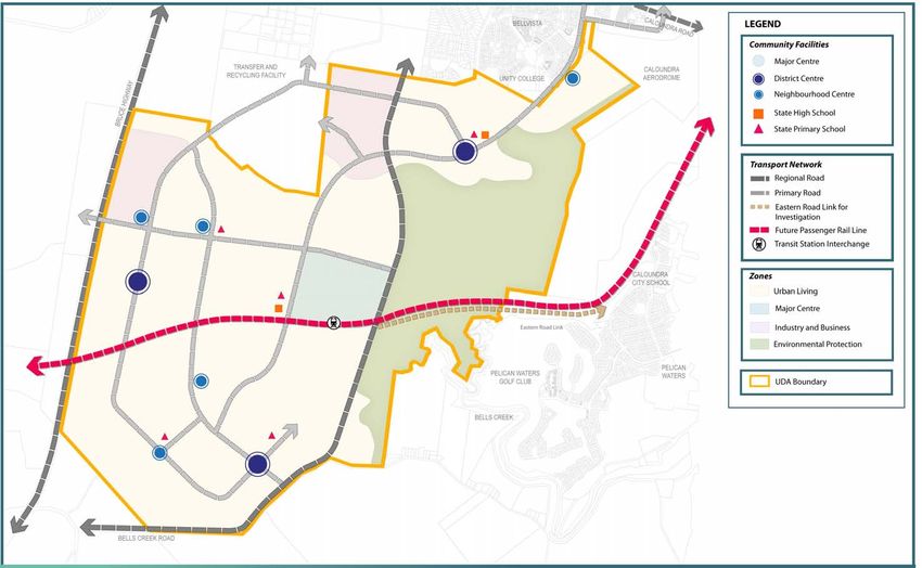
For consultation - not government policy
    2.0           Strategic Context

     A prosperous community                           ÈÈ The majority of land to the east of
                                                         Kawana Arterial along Lamerough Creek,
     ÈÈ A mix of land uses facilitates the delivery
                                                         Bells Creek North and Bells Creek South
        of jobs that contribute to a high level of
                                                         are protected and rehabilitated.
        self containment within the Sunshine
        Coast region. This is promoted through        ÈÈ Integrated water cycle management
        the provision of local employment                contributes to the water quality values of
        opportunities through a network of               the Pumicestone Passage and the Bells
        centres and the development of industrial        and Lamerough Creek riparian corridors
        areas which contributes to a resilient           and their tributaries.
        economy.                                      ÈÈ Buildings and other development
     ÈÈ Caloundra South provides opportunities           respond positively to the key
        for a wide range of employment activities        environmental issues of climate
        to establish in the community, including         change, energy efficiency and waste
        work-from-home opportunities and start-          management.
        up opportunities for local entrepreneurs.     ÈÈ A comprehensive greenspace network
     ÈÈ Caloundra South's wide range of                  ensures important ecological and scenic
        education and training opportunities             values are protected and enhanced,
        means that the community is well                 and adequate parks and recreation
        equipped to compete in the global                opportunities are provided.
        economy.                                      ÈÈ Residents take advantage of
                                                         opportunities to move around using
     A sustainable community                             active and public transport, thus reducing
     ÈÈ Development protects and supports the            private motorised travel and its impacts
        regional and national biodiversity values        on the environment.
        external to the UDA in the Pumicestone        ÈÈ Cultural and community services, open
        Passage.                                         space, sport and recreational facilities
     ÈÈ Development within Caloundra South               meet the needs of the community and
        provides for the enhancement of local            encourage active, healthy lifestyles.
        and regional natural ecosystems               ÈÈ Development provides a visual and
        and biodiversity values through the              acoustic buffer adjacent to the Bruce
        protection of ecologically important areas       Highway ensuring the character and
        and the establishment of buffers to these        visual values of this gateway to the
        areas.                                           Sunshine Coast are sustained.
                                                      Map 2 - Vision represents how Caloundra
                                                      South may develop over time to meet the
                                                      vision in the scheme.

4    Caloundra South Urban Development Area proposed Development Scheme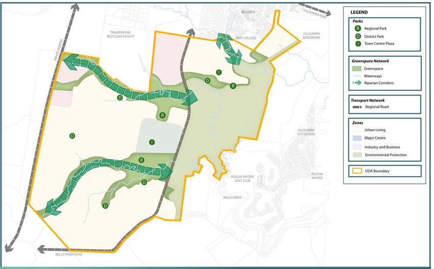
For consultation - not government policy
                                                      Strategic Context                                                                             2.0

 Map 2 - Vision

                                                                 Produced by the Urban Land Development Authority (ULDA) 2011
                                                                 Map is intended for illustration purposes only and unless stated is not to scale

                                           Caloundra South Urban Development Area Proposed Development Scheme                                             5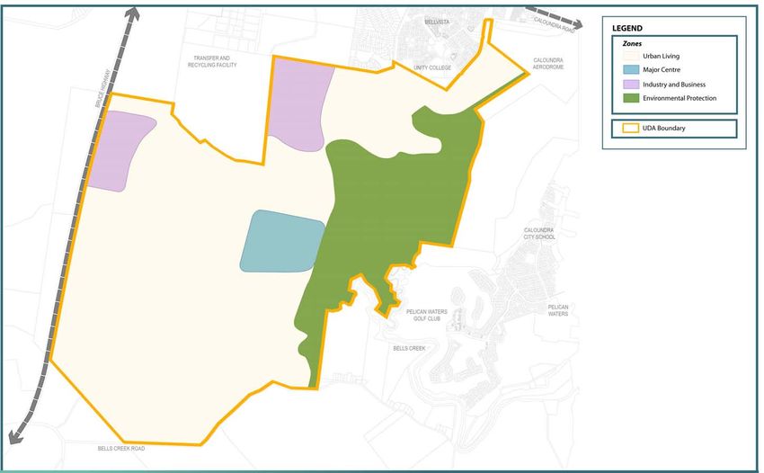
For consultation - not government policy
    3.0            Land Use Plan:                      Context

     3.1 Operation of the                            (ii) UDA self assessable development            Figure 1: Components of the land use plan and their relationship
                                                          (column 2)
         land use plan                               (iii) UDA assessable development which is
     The land use plan establishes the UDA                 permissible (column 3A)                                                               Vision
     development requirements which regulate
                                                     (iv) UDA assessable development which is
     development to ensure the achievement of
                                                          prohibited (column 3B).
     the vision for the UDA.
                                                                                                                                  UDA development requirements
                                                     3.1.3 Meaning of development
     3.1.1   UDA development requirements
                                                     Development is as defined under the
     The UDA development requirements are
                                                     Sustainable Planning Act 2009 (SPA), section
     expressed as:
                                                     7 and 10.                                                    UDA-wide criteria                                 Zone Provisions
     (i) UDA-wide criteria
                                                     For the purposes of administering the              ÈÈ Neighbourhoods                                 ÈÈ Zone intents
     (ii) zone provisions                            scheme in relation to an environmentally           ÈÈ Centres                                        ÈÈ Zone Plan
     (iii) self-assessable provisions.               relevant activity (ERA), material change of
                                                                                                        ÈÈ Housing diversity and affordability            ÈÈ Levels of assessment table
                                                     use of premises for an ERA also has the
     Refer to Figure 1.                                                                                 ÈÈ Employment opportunities
                                                     meaning in the SPA, section 10, material
     The UDA development requirements apply to       change of use (b) - (e).                           ÈÈ Movement network
     all UDA assessable development in the UDA                                                          ÈÈ Greenspace network
     to the extent relevant.                         3.1.4 Schedules                                    ÈÈ Community facilities
     The zone provisions consist of:                                                                                                                                      Schedules
                                                     Schedule 1 identifies development that is          ÈÈ Natural and cultural values
                                                     exempt from assessment for the whole UDA.                                                            ÈÈ UDA-wide exempt development
     ÈÈ the zone plan                                                                                   ÈÈ Community safety and development
     ÈÈ a zone intent for each zone                  Schedule 2 provides the use and                       constraints                                    ÈÈ Definition
                                                     administrative definitions required to             ÈÈ Service infrastructure                         ÈÈ Self-assessable provisions
     ÈÈ a level of assessment table for each zone.
                                                     interpret and apply the scheme.
                                                                                                        ÈÈ General requirements
     The ULDA has prepared a number of
                                                     Schedule 3 sets out the specific requirements
     guidelines providing more detail regarding
                                                     applying to self-assessable development and
     how to achieve the UDA development
                                                     are referenced in the levels of assessment
     requirements. The guidelines are available
                                                     table.                                                                                ULDA guidelines
     on the ULDA website at www.ulda.qld.gov.au

     3.1.2 Levels of assessment
     The levels of assessment prescribes for each
     zone:
     (i) UDA exempt development (column 1)

6    Caloundra South Urban Development Area Proposed Development Scheme
For consultation - not government policy
                                                                                                                                  Land Use Plan:                        Context                  3.0

 3.2 Development                                 3.2.2 Development approval                        The ULDA, when considering a development             way consistent with the vision and UDA
                                                                                                   application:                                         development requirements
     assessment                                  Identification of development as UDA
                                                                                                                                                    ÈÈ is consistent with existing, approved or
                                                 assessable development does not mean              (i) is not bound by any decision
                                                 that a UDA development approval (with or              made regarding an application for               proposed development in the vicinity.
 3.2.1 Development consistent with the
                                                 without conditions) will be granted.                  consideration in principle                   However, a context plan may not be required
       land use plan
                                                 UDA assessable development requires a UDA         (ii) may give such weight as it considers        where, in the opinion of the ULDA, the
 UDA self-assessable development must                                                                   appropriate to the decision in respect      proposed development will not compromise
 comply with the applicable provisions.          development application to be lodged with
                                                 the ULDA for assessment and decision.                  of the application for consideration in     the UDA development requirements and will
 UDA assessable development is consistent                                                               principle.                                  not unreasonably prejudice the opportunities
 with the land use plan if:                      Approval is required for UDA assessable                                                            for development of the remaining area.
                                                 development to be undertaken.                     3.2.5 Development application
 (i) the development complies with the UDA                                                                                                          A context plan is part of the supporting
     development requirements, or                3.2.3 Infrastructure agreements                   To the extent the UDA development                information for a UDA development
 (ii) the development does not comply with                                                         requirements are relevant, they are to be        application and will not form part of any
                                                 A UDA development condition may require           taken into account in the preparation of         development approval.
      one or more of the UDA-wide criteria, or
                                                 the land owner to enter into an infrastructure    a UDA development application and the
      zone intents but:                                                                                                                             For further advice on preparing a context
                                                 agreement, under section 97 of the Act, to        assessment of the application by the ULDA.
    a. the development does not conflict         address the provisions and requirements of                                                         plan refer to the applicable ULDA Practice
       with the UDA vision, and                  the infrastructure plan and implementation        The infrastructure plan and implementation       Note available on the ULDA website.
    b. there are sufficient grounds to           strategy.                                         strategy may include further information
       approve the development despite the                                                         which should be taken into account in            3.2.7 Plan of Development
       non compliance with the UDA-wide          3.2.4 Consideration in principle                  the preparation, design and feasibility of
                                                                                                                                                    A Plan of Development (PoD) may accompany
       criteria and zone intents.                                                                  development proposals.
                                                 A request may be made to the ULDA for                                                              an application for a material change of use
 Otherwise, the UDA assessable development       consideration in principle for proposed                                                            or reconfiguring a lot and may deal with
                                                                                                   3.2.6 Context plans
 is inconsistent with the land use plan and      development.                                                                                       residential or non-residential development
 must be refused.                                                                                  The ULDA may require an applicant to submit      as well as operational work.
                                                 In considering the request, the ULDA may          a context plan as part of a UDA development
 In this section 'grounds' means matters of      decide to:                                                                                         A PoD is prepared by an applicant and
                                                                                                   application.
 public interest which include the matters                                                                                                          may include maps, graphics and text
 specified as the main purposes of the Act as    (i) support all or part of the proposed           A context plan may be required to ensure a       that collectively demonstrate how future
 well as:                                            development, with or without                  proposed development:                            development (i.e. lot and building design)
                                                     qualifications that may amend the                                                              will contribute towards the achievement of
 (i) superior outcomes                               proposed development                          ÈÈ contributes towards the achievement
                                                                                                                                                    the vision and be consistent with the relevant
 (ii) overwhelming community need.                                                                    of the vision and UDA development
                                                 (ii) oppose all or part of the proposed                                                            UDA development requirements.
                                                                                                      requirements
 'Grounds' does not include the personal              development
 circumstances of an applicant, owner or                                                           ÈÈ does not prejudice the ability for
                                                 (iii) give no indication of either support or
 interested third party.                                                                              surrounding land to be developed in a
                                                       opposition to all or part of the proposed
                                                       development.
                                                                                                                                Caloundra South Urban Development Area Proposed Development Scheme     7
For consultation - not government policy
3.0 Land Use Plan: UDA wide criteria
The PoD can not include land beyond the 3.2.9 Interim use 3.2.10 Relationship with local 3.3 UDA-wide criteria
boundary of the land the subject of the government planning scheme
An interim use is a land use that, because 3.3.1 Neighbourhoods
application, but may cover only part of the and other legislation
of its nature, scale, form or intensity, is
land the subject of the application. Development delivers neighbourhoods that:
not an appropriate long term use of the This scheme may apply a provision of a
Development approved in accordance with land. Interim land uses may occur where planning instrument, or a plan, policy or ÈÈ are compact and walkable, comprising
a PoD requires no further development appropriately developed and operated code made under the Sustainable Planning the area within a 5 minute walk (400
approval under the scheme. and where located in areas which will not Act 2009 (SPA) or another Act. However, metre radius) of a community focal point.
compromise the zone intent in the long term. the scheme prevails to the extent of any A cluster of neighbourhoods supports a
For further advice on preparing a PoD,
Possible interim uses are identified in the inconsistency with those instruments. neighbourhood centre
refer to the applicable ULDA Practice Note
zone provisions.
available on the ULDA website. Other legislation ÈÈ have a highly permeable, legible street
The ULDA may approve an interim use where pattern designed to promote walking and
3.2.8 Notification requirements it can be demonstrated that the interim use In addition to assessment against the
cycling as the primary modes for local
will not preclude or delay an appropriate scheme, development may require
A UDA development application will require movement
long term use or intensity of development. assessment against other legislation
public notification if the application includes: including for example the Plumbing and ÈÈ contain a variety of dwelling types
Information to support an application for an including affordable and accessible
ÈÈ a proposal for development which does interim use may include: Drainage Act 2002 and SPA.
housing
not comply with one or more of the UDA-
ÈÈ a context plan 3.2.11 Land not included in a zone ÈÈ are designed to respond to local site
wide criteria or zone intents
ÈÈ a schedule of land supply and projected characteristics, settings, landmarks
ÈÈ development which, in the opinion of This section applies to land which is not
take-up rates and views, and use natural features to
the ULDA, may have undue impacts on shown in the land use plan as being included
provide local identity and character
the amenity or development potential of ÈÈ plans showing how the development in a zone (unallocated land).
adjoining land under separate ownership, could transition from the proposed ÈÈ have a centrally located focal point
interim use to an appropriate longer term Where the unallocated land adjoins land in a which must comprise of at least a
including development for a non-
use1. zone, the unallocated land is deemed to be neighbourhood park but which can
residential use adjacent to land approved
included in that zone. also include a public transport stop,
for or accommodating a residential use in The ULDA may impose a condition of
the urban living zone. Where the unallocated land adjoins land community facility, local shop or similar
approval that limits the duration of an
interim use. included in different zones, the unallocated ÈÈ are interconnected and provide good
The ULDA may require public notification
land is deemed to be included in those zones access to public transport, parks, schools
in other circumstances if the development Interim uses will only be approved where it
with the centreline of the unallocated land and other community facilities and
application is for a use, a size or nature can be demonstrated that the use will not
being the boundary between the zones. neighbourhood centres
which, in the opinion of the ULDA, warrants prejudice the achievement of the vision for
public notification. ÈÈ provide a safe environment through the
the UDA.
application of Crime Prevention Through
Environmental Design (CPTED) principles
1 The applicable ULDA guideline provides examples of such as passive surveillance of public
how this might be achieved.
spaces, and a legible street network that
minimises traffic impacts on residential
areas
8 Caloundra South Urban Development Area Proposed Development SchemeFor consultation - not government policy
Land Use Plan: UDA wide criteria 3.0
Table 1 - Height, gross floor area and density provisions
Zones Urban living zone Major centre zone Industry and
business zone
Neighbourhoods Neighbourhood District centre District centre District centre Core Frame
centres (each) north south west
Maximum building 2 storeys (9m) 3 storeys 5 storeys 5 storeys 5 storeys 10 storeys 6 storeys Area adjacent to
height Bruce Hwy - 11m
Area adjacent to
Kawana Arterial -
15m *
Minimum net 15 25 35 35 35 60 40 N/A
residential density
Indicative Gross Floor Area
ÈÈ Retail and N/A 1,500m2 8,000m2 5,000m2 5,000m2 70,000m2 **
entertainment
ÈÈ Commercial N/A 1,000m2 4,000m2 2,000m2 2,000m2 50,000m2 ***
Total 120,000m2 650,000m2
Community 500-1,800m2 3,000-8,000m2 3,000-8,000m2 3,000-8,000m2 10,000 - 30,000m2
services****
(indicative GFA)
*Greater heights in the Industrial and Business Zone adjacent to the Kawana Arterial may be considered where unable to be seen when travelling on the Kawana Arterial and by residential neighbourhoods, within and external to the UDA boundary.
**Does not include low intensity uses such as showrooms and outdoor sales.
***Greater commercial gross floor area will only be supported post 2031 if the following can be demonstrated:
a. The additional commercial floorspace does not compromise Maroochydore as the Principal Regional Activity Centre for the Sunshine Coast.
b. Transport infrastructure can service the future development and not jeopardise the road hierarchy and movement network.
c. The additional commercial floor space contributes to self containment within the Sunshine Coast sub region providing opportunities for economic growth and increased employment opportunities.
****Includes community facilities as well as privately delivered services such as health, child care, aged care and respite services, sport and recreation and youth services
Caloundra South Urban Development Area Proposed Development Scheme 9For consultation - not government policy
3.0 Land Use Plan: UDA wide criteria
ÈÈ locates higher density residential close ÈÈ are commensurate with their role in ÈÈ locate higher density development, Small scale shop or office activities with
to centres, transit nodes, local parks and the Regional Plan and the UDA centres including residential, and key community an aggregate gross floor area of 250m2
green corridors, or along busier streets network facilities in the core of the centre. The or less are acceptable outside a centre
that lead directly to centres ÈÈ comprise of major, district and core is the area within the 400 metre where the development will not constitute
ÈÈ are designed to promote optimum solar neighbourhood centres. Centres are focal primary walking catchment of the major an incremental expansion to a designated
access and use of prevailing breezes points for their catchments and provide a transit node or central focal point centre, and will not have a detrimental
wide range of services and facilities ÈÈ the frame and district centres can also impact on residential amenity.
ÈÈ locate urban neighbourhoods around
transport nodes and higher order centres ÈÈ respond to local site characteristics, include urban neighbourhoods with Map 3 - Centres and transport network
to maximise accessibility settings, landmarks and views, and higher density residential development indicates the general distribution of centres
ÈÈ appropriately interface with existing use natural features to provide specific ÈÈ contain commercial, retail and other uses within the UDA.
residential development adjoining the identity and character which require high levels of accessibility.
Centres are designed to achieve:
UDA boundary, by ÈÈ are active places characterised by a high The major centre is the focal point of the
quality public realm and safe, attractive ÈÈ the principles and design standards set
ÈÈ considering densities through community. It will provide a wide range of
pedestrian areas out in the applicable ULDA guideline
minimum lot sizes and the location of facilities and services, including most higher-
ÈÈ have a park, plaza or square as a central order services. It has the greatest mix of ÈÈ the specific requirements in Table 1.
property boundaries
focal point for community activities uses and the highest development densities
ÈÈ access arrangements 3.3.3 Housing diversity and
ÈÈ are located to maximise accessibility. within the UDA.
ÈÈ uses affordability
They provide a focus for linear The staging and timing of the delivery of the
ÈÈ height. greenspace and the road network, and Development delivers:
major centre must not prejudice the delivery
Neighbourhoods are designed to achieve: act as hubs for feeder public transport of the Maroochydore centre. ÈÈ housing choice and diversity to meet the
and walking and cycling networks needs of the community, through a mix
ÈÈ the standards set out in the applicable The highest density of activities and key
ÈÈ ensure higher order centres are designed of densities, types, designs, tenures and
ULDA guideline community facilities are in the core of the
around planned public transport services. levels of affordability, to cater for a range
ÈÈ the minimum net residential densities major centre close to the major transit node.
Public and active transport is given of lifestyles, incomes and life cycle needs
and specific requirements in Table 1. priority within centres District centres are the intermediate tier in ÈÈ residential development that
ÈÈ have a permeable road network that the centres hierarchy and provide a wide complements or enhances the character
3.3.2 Centres provides vehicle access into centres range of goods and services with relatively of the neighbourhood and streetscape,
through a network of low-speed urban high densities. and contributes to the creation of an
Development delivers centres that:
streets Neighbourhood centres provide a range of attractive and safe environment
ÈÈ are for knowledge, community and
ÈÈ contain a core and frame in the major services and activities to meet day-to-day ÈÈ dwellings that provide appropriate levels
commerce, accommodating a range
centre, where the core accommodates needs. Neighbourhood centres are located of amenity and privacy, and adequate
of employment, education, cultural
the highest order mixed use activities. on collector or higher order roads with good outdoor areas and car parking to meet
and community, retail, open space,
The frame accommodates lower intensity access by public and active transport. varying household needs
entertainment, sport and recreational
facilities which meet the needs of the and car dependent uses (i.e. showrooms)
community, encourage community on the periphery of the centre to support
interaction and active, healthy lifestyles the core
10 Caloundra South Urban Development Area Proposed Development SchemeFor consultation - not government policy
Land Use Plan: UDA wide criteria 3.0
ÈÈ energy efficient, climatically responsive ÈÈ an appropriate height of buildings, ÈÈ the provision of a public transport Map 3 - Centres and transport network
design including appropriate solar structures and advertising devices that network that is readily accessible to the identifies the preliminary road and public
orientation, shading, cross ventilation, does not impact upon the amenity of community (90% of all dwellings should transport network for the UDA.
natural lighting and passive cooling the area, in particular the visual amenity be within 400 metres of a potential public
The applicable ULDA guideline provides
techniques. of the Bruce Highway as an important transport service), and provides effective
additional information to assist in achieving
gateway to the Sunshine Coast links to centres, the rail station, public
The ULDA's applicable guidelines provide these criteria.
ÈÈ a road network that does not provide transport interchange and key external
additional information on how to achieve
direct access from the primary road destinations
these criteria. 3.3.6 Greenspace network
network nor encourage industrial traffic ÈÈ the delivery of a future rail line
through residential neighbourhoods. which follows the protected corridor Development contributes to natural green
3.3.4 Employment opportunities
is integrated into the urban fabric. space areas by:
Development delivers: The applicable ULDA guideline provides
Opportunity to slightly move the corridor ÈÈ retaining where possible locally
additional information on how to achieve
ÈÈ a diverse range of employment and will only be considered where it does not significant wetlands, remnant vegetation
these criteria.
training opportunities that complement compromise the geometry and operation and habitat for fauna
and reinforce the Sunshine Coast of heavy rail
3.3.5 Movement network ÈÈ protecting important landscape and
Industrial Park to the north of the UDA ÈÈ The transit station interchange will visual quality values
and contributes towards self containment Development contributes to: be integrated into the major centre,
ÈÈ enhancing wetland communities as part
in the Sunshine Coast Region ÈÈ an effective, efficient and integrated greenspace network and pedestrian cycle
of stormwater management
ÈÈ low and medium impact industry movement network that provides a network, creating an important focal
point for residents, workers and visitors ÈÈ providing ecological corridors and
including research and technology high level of safety and accessibility,
to Caloundra South linkages, including to areas outside the
facilities, service industry and maintains residential amenity and
neighbourhood or community.
warehouses promotes the use of public and active ÈÈ a comprehensive active transport
ÈÈ an appealing industrial and business transport particularly for local trips (walking and cycling) network based Development delivers parks that:
environment providing a high level of ÈÈ a major road network that provides around major active transport spines,
ÈÈ contribute to the achievement of a
amenity effective links between centres and the supplemented with local links and a safe
network of greenspace that caters
neighbourhoods they serve, and to the and permeable street network within
ÈÈ non-industrial uses which are limited for a variety of recreation functions
external road network neighbourhoods. The active transport
in scale and type to those uses that are and experiences to meet the needs of
ÈÈ a road network that accommodates a network provides safe and direct links to
compatible and able to demonstrate residents and visitors
range of users including cars, service key destinations including centres, public
a nexus with industrial uses. Non- ÈÈ are accessible for users
vehicles, pedestrians, cyclists and public transport stops, parks and schools
industrial uses are not to duplicate
ÈÈ elements of the movement network ÈÈ provide for multiple purposes and
commercial or retail uses intended for the transport
should be delivered generally in uses including recreational, sporting,
centres network ÈÈ a road network that has a functional
accordance with Map 3 - Centres and ecological and stormwater management
ÈÈ appropriate transitioning of land hierarchy, facilitates longer travel functions
movements, provides multiple access transport network.
uses at the interface with residential
neighbourhoods routes to and through neighbourhoods
and minimises traffic impacts on
residential areas
Caloundra South Urban Development Area Proposed Development Scheme 11For consultation - not government policy
3.0 Land Use Plan: UDA wide criteria
ÈÈ incorporate existing natural features and linear habitat. Fauna refuge areas are to for community development and enhance 3.3.8 Natural values
where possible and are landscaped to be located adjacent to Bells Creek North and community wellbeing
Caloundra South UDA is located within the
assist in creating neighbourhood identity Bells Creek South to provide a safe haven ÈÈ a range of services and community uses catchment that connects to the Pumicestone
and wayfinding for fauna during heavy rainfall. For land in such as schools, child care centres and Passage and the internationally recognised
ÈÈ retain existing significant vegetation to the northern part of the UDA in the vicinity medical facilities that are accessible RAMSAR wetlands. Pumicestone Passage is
the greatest extent practicable of Lamerough Creek, a Flora and Fauna and appropriate to the needs of the a significant environmental feature within
Management Plan is required to address the community
ÈÈ are shaped and embellished to suit their the region and forms part of the Moreton Bay
Acid Frog habitat and management of flora
anticipated use ÈÈ services and community uses where State Marine Park.
values.
ÈÈ support the community's recreational accessibility to the facility's target market
Development responds to the natural
needs and provide opportunities for Development adjacent to the greenspace is maximised though good access to
features of the land and delivers:
community and special events. network which contains or is within close public transport, pedestrian and cycle
proximity to valuable ecological features, paths ÈÈ protection of significant environmental
The riparian corridors are a sufficient width to such as the Blackbutt Forest in the north and ecological values
ÈÈ a hierarchy of services and community
protect and improve the ecological function east of the site, must address potential uses in neighbourhood, district and major ÈÈ minimal emissions to land, water and
of these corridors and includes: edge effects. This will vary dependent upon centres. Neighbourhood level community atmosphere
ÈÈ approximately 100m across Bells Creek the nature of the ecological feature but facilities and services are located within ÈÈ efficient use of land and resources.
South may include a variety of treatments such walking distance for most residents, meet
as additional planting, linear open space, everyday needs and are provided early The design, siting and layout of
ÈÈ approximately 200m across Lamerough
boulevard streets and larger lots. The in development. District level community development:
Creek
appropriate response will be determined at facilities and services serve a broader
ÈÈ approximately 200m across Bells Creek ÈÈ avoids and/or offsets development
the development application stage. population catchment, reflect the diverse
North recognising that part of the corridor impacts on areas of biodiversity value
The greenspace networks are distributed needs of the population and are provided
is located outside the UDA boundary ÈÈ maintains and improves ecological
generally in accordance with Map 4- in response to population growth
The outer edges of these corridors away from connectivity in the local urban context
Greenspace network. thresholds. Major level of services and
the creek top of bank may include: community uses are of a higher order and ÈÈ incorporates landscaping with endemic
Greenspace networks are located and accessed by a sub-regional population. species that contribute to the bushland
ÈÈ stormwater management devices
designed to achieve the principles and character and flora and fauna habitat,
ÈÈ fauna refuge areas design standards set out in the applicable Map 5 - Community facilities. indicates the and fauna movement
ÈÈ pedestrian / cyclist paths ULDA guideline. general distribution of community facilities
ÈÈ minimises adverse impacts on natural
ÈÈ passive open space. within the UDA.
landforms and the visual amenity of the
3.3.7 Community facilities Community facilities are designed to achieve site
The riparian corridors will be subject to
extensive rehabilitation works to enhance Development facilitates the delivery of: the principles and standards set out in the ÈÈ maintains the ecological health and
flora and fauna habitat values. Vegetated applicable ULDA guideline. environmental values of surface and
ÈÈ sustainable communities with a strong
buffers will extend from the creek top of groundwater, including wetlands and
community identity and access to
bank. The corridors will contain a diversity of waterways in and adjacent to the UDA
services and community facilities that
habitat types to provide wildlife connectivity ÈÈ maintains the functioning and
meet diverse needs, maximise potential
12 Caloundra South Urban Development Area Proposed Development SchemeFor consultation - not government policy
Land Use Plan: UDA wide criteria 3.0
characteristics of the hydrological In order to protect the ecological condition The adoption of the formal Water Quality 3.3.9 Community safety and
network, including surface and of the Pumicestone Passage, Bells Creek Objectives for Pumicestone Passage development constraints
groundwater and Lamerough Creek, development is necessitates the adoption of water treatment
to incorporate best practice stormwater Development ensures that people and
ÈÈ incorporates total water cycle measures that are more stringent than
management, water management property are safe from potential hazards and
management and water sensitive urban those required elsewhere in South East
solutions and sediment and erosion control disturbances including landslip, bushfire,
design principles to appropriately Queensland for other catchments and
techniques2. noise and flooding4 including the predicted
manage floodwater and stormwater developments.
effects of climate change.
ÈÈ manages air quality, noise and hazardous A water quality monitoring program must Protection of Groundwater Resources
Future residents are to be provided with
materials according to current standards be developed at the outset of development,
Development incorporates best practice a level of amenity that addresses noise
ÈÈ occurs in accordance with best practice except for the provision of community
groundwater management which: sources. Sensitive uses to nearby noise
techniques for the management of acid infrastructure located south of Bellvista. This
ÈÈ substantially maintains the regional sources such as the Caloundra Aerodrome
sulphate soils is to be endorsed by the ULDA and set out
(large scale) flow paths and water quality and the Bruce Highway are to be protected.
requirements and processes for water quality
ÈÈ promotes innovative and efficient use of The preferred means to control noise impacts
monitoring including, but not limited to: of groundwater;
energy and water will be determined at the development
ÈÈ setting monitoring program objectives ÈÈ protects downstream groundwater
ÈÈ maximises recycling opportunities and application stage.
dependent ecosystems; and
reduces waste generation. ÈÈ identification of appropriate monitoring
locations ÈÈ provides for artificial groundwater
Protection of Water Quality in Pumicestone recharge infiltration systems that involve 4 The Queensland Floods Commission of Inquiry
Passage, Bells Creek and Lamerough Creek ÈÈ specification of parameters for
passive engineering solutions, such as is investigating the January 2011 flood disaster,
monitoring including a review of existing provisions relating to
Development protects the water quality of seasonal wetlands where necessary, flooding and flood risk mitigation.
ÈÈ designing an effective sampling program to avoid any adverse impacts of
surface and groundwater and the ecological Consequently the provisions of this development
(including frequency and dry/wet development.
condition of the Pumicestone Passage, scheme with respect to the management of flooding
weather monitoring) and flood risk mitigation may be subject to change
Bells Creek and Lamerough Creek and their Development complies with a Groundwater at the direction of the Queensland Government in
tributaries. ÈÈ undertaking data analysis the near future.
Management Plan, established at the outset,
ÈÈ reporting. documenting measures to comply with the This should be taken into account by applicants
and assessment managers when considering
groundwater management criteria stated development in this UDA. Applicants are advised
2 This includes the site achieving: above. to make relevant enquiries regarding the status of
the provisions relating to flooding to the time of
(i) Water Quality Objectives for Basin No. 141 in
the Pumicestone Passage Environmental Values Map 6 - Natural values shows the key natural lodgement.
and Water Quality Objectives set by DERM, and the and cultural values in the UDA.3
Environmental Protection (Water) Policy 2009, in
particular the area within Basin No. 141 designated
as area PLE - Pumicestone Passage North (Enclosed 3 The information contained within these maps is
Coastal/Lower Estuary) and may be subject to review. Applicants should check
Sunshine Coast Regional Council's planning scheme
(ii) Regional Plan Implementation Guidelines No. 7,
for the most up to date information.
Water sensitive urban design: Design objectives for
urban stormwater management (November 2009) by
the Department of Infrastructure and Planning.
Caloundra South Urban Development Area Proposed Development Scheme 13For consultation - not government policy
3.0 Land Use Plan: UDA wide criteria
Development adjoining the Bruce Highway Development located near the Caloundra Flooding and Flood Management 3.3.10 Service infrastructure
Aerodrome ÈÈ Development occurs in areas that
A buffer is to be provided between the limit The UDA delivers efficient and effective use
of development and the Bruce Highway, Development located near the Aerodrome are flood free or filled to achieve an of infrastructure and services.
fulfilling the following: must not prejudice the ongoing operations of acceptable flood event8.
Development ensures infrastructure and
the Aerodrome6. Nearby future development ÈÈ Development ensures that stormwater
ÈÈ provision of a predominantly landscaped services are:
that has the potential to receive intrusive run off at the site's boundaries does
treatment that achieves a natural and
noise is required to address the following: not exceed that which presently exists, ÈÈ provided in a timely, orderly, integrated
rural edge as viewed from the Bruce
and there is 'no net worsening' of flood and coordinated manner to support
Highway ÈÈ justify that the proposed land use is
conditions at the site's boundaries. urban uses and works
ÈÈ provision of visual separation between suitable based on the extent of noise
at the subject site and information Any seasonal wetlands installed for ÈÈ available or capable of being
development and the highway. Acoustic
about future noise projections from stormwater management purposes are to made available (including key
walls are not visually prominent and do
the Sunshine Coast Airport Corporation be subject to a maintenance arrangement infrastructure such as roads, public
not result in a continuous, monotonous
comprising both fixed wing aircraft between ULDA and the land owner and active transport, water supply,
stretch of acoustic wall along the length
movements and helicopter movements. confirming the maintenance obligations. sewerage, drainage, park network,
of the site's frontage to the Bruce
This will include information about: community facilities, medical facilities
Highway Map 7 - Development constraints shows and GP services, electricity and
ÈÈ inclusion of a variety of techniques at ÈÈ areas forecast to be exposed to the key community safety and development telecommunications)
different locations including separation between 20 and 50 noise events a constraints affecting the UDA.
day exceeding 70 dB(A) ÈÈ designed to allow for future
distances, mounding, landscaping, noise
developments in information technology
attenuation measures and recreational ÈÈ any available Transparent Noise
and providing access to technology in
opportunities Information Package (TNIP) to
8 As identified on Map 7, parts of the UDA are subject neighbourhood facilities
ÈÈ compliance with the applicable noise generate N70 contours to inundation by a Q100 flood event. For information
about how to address potential flooding, refer to: ÈÈ located and designed to maximise
standards and requirements5. ÈÈ inclusion of a variety of techniques
efficiency and ease of maintenance
including separation distances, i) the Queensland Coastal Plan
mounding, landscaping and other noise ii) Sunshine Coast Regional Council for habitable
ÈÈ located and designed to consider total
5 This includes the Department of Transport and Main floor levels life-cycle costs.
Road Traffic Noise Management: Code of Practice attenuation measures
with respect to external road traffic noise levels and ÈÈ provision of suitable levels of indoor iii) State Planning Policy 1/03 and associated
Infrastructure is designed to achieve the
the Queensland Development and Section MP 4.4 guideline for siting requirements for key elements of
'Buildings in a Transport Noise Corridor'. residential amenity to comply with the community infrastructure and principles and standards set out in the
applicable Australian Standard7 iv) the applicable ULDA guideline addressing applicable ULDA guideline.
ÈÈ provision of suitable levels of outdoor flooding.
residential amenity.
6 It is possible that investigations will show that
certain areas around the aerodrome are not suitable
for residential development. In this instance non-
residential uses, not impacted by aircraft noise and
consistent with the vision, will be required instead.
7 Refer to AS 2021 : 2000 "Acoustics - Aircraft Noise
Intrusion - Building Siting and Construction
14 Caloundra South Urban Development Area Proposed Development SchemeFor consultation - not government policy
Land Use Plan: UDA wide criteria 3.0
3.3.11 General requirements End of trip facilities for pedestrians and
cyclists, including secure undercover bicycle
Site area and landscaping:
storage facilities, showers and lockers are
ÈÈ sites have sufficient dimensions to to be provided as part of development in
accommodate buildings, parking, access accordance with the relevant requirements
and circulation areas and landscaping of section MP 4.1 Sustainable Buildings of
ÈÈ landscaping is provided to enhance the Queensland Development Code.
visual amenity of the locality. Advertising devices10:
Sub-tropical design measures ÈÈ cater for the needs of display homes and
Development provides built forms that businesses to clearly identify the location
respond to the subtropical environment, and the goods or services which are
including eaves, roof overhangs and sun supplied to the public
shading devices. ÈÈ are consistent with the scale and design
of existing buildings and other works
Parking and end of trip facilities:
on the site and in the locality, and
Parking is provided in accordance with the complement the local streetscape
rates and standards set out in the planning
ÈÈ where appropriate, reflect the character
scheme9. The ULDA will consider proposals
of the area
for a reduced number of car parking spaces
ÈÈ are sited and provided on premises
where it can be justified due to factors
having regard to safety and amenity.
including:
ÈÈ availability of on-street car parking
ÈÈ public transport accessibility
ÈÈ overall accessibility, including, for
residential development, location within
or adjoining a centre
ÈÈ potential for sharing car parking spaces
by different uses and activities
ÈÈ target markets for residential
development.
9 Refer to Sunshine Coast Regional Council's Planning
Scheme
10 Refer to Sunshine Coast Regional Council's Planning
Scheme
Caloundra South Urban Development Area Proposed Development Scheme 15You can also read