CAPE TOWN GLOBAL FUTURE CITIES PROGRAMME - Prosperity Fund
←
→
Page content transcription
If your browser does not render page correctly, please read the page content below
Prosperity Fund
GLOBAL FUTURE CITIES PROGRAMME

        CAPE
       TOWN
           CITY CONTEXT REPORT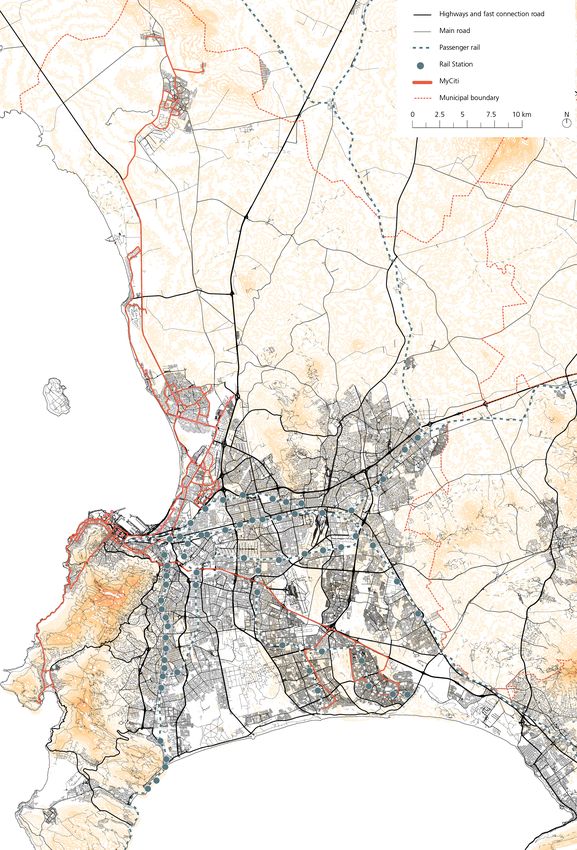

Prosperity Fund
GLOBAL FUTURE CITIES PROGRAMME

          CAPE
         TOWN
           CITY CONTEXT REPORT
                    December 2018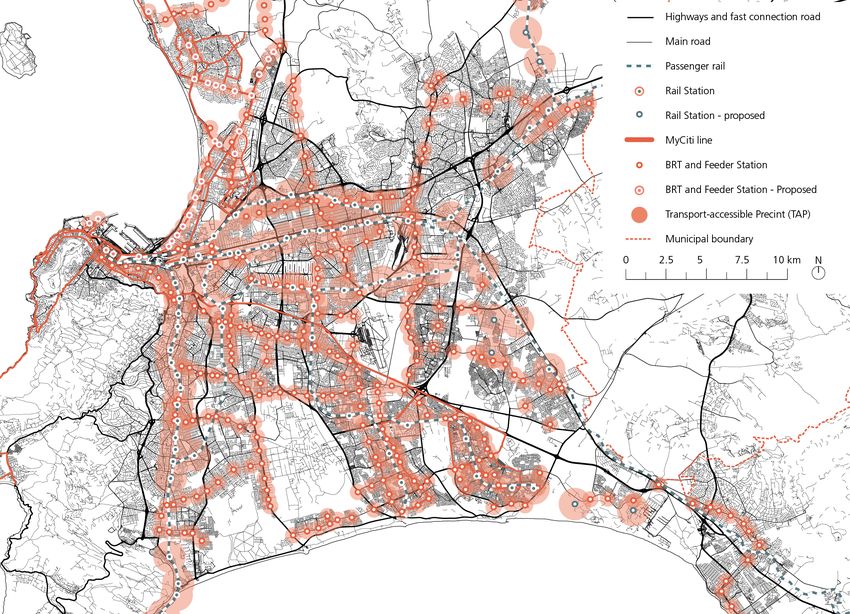
Global Future Cities Programme
CAPE TOWN
City Context Report

UNITED NATIONS HUMAN SETTLEMENTS PROGRAMME
P.O. Box 30030, Nairobi 00100, Kenya
www.unhabitat.org

Funded by: United Kingdom Foreign and Commonwealth Office (UK FCO)
Lead executive agency: UN-Habitat: Urban Planning and Design Lab
Academic partner: International Growth Center (IGC)
Professional partner: United Kingdom Built Environment Advisory Group (UKBEAG).

Disclaimer
The designations employed and the presentation of material in this report do not imply the expression of any opinion
whatsoever on the part of the Secretariat of the United Nations concerning the legal status of any country, territory,
city or area or of its authorities, or concerning the delimitation of its frontiers or boundaries, or regarding its economic
system or degree of development. The analysis conclusions and recommendations of this publication do not necessarily
reflect the views of the United Nations Human Settlements Programme or its Governing Council or its member states.
Reference of this publication of any specific commercial products, brand names, processes, or services, or the use of
any trade, firm, or corporation name does not constitute endorsement, recommendation, or favouring by UN-Habitat
or its officers, nor does such a reference constitute an endorsement of UN-Habitat.

Acknowledgments

City context report coordinators (Cape Town): Dongni Niu, Francesco Tonnarelli (UN-Habitat)

United Kingdom Foreign and Commonwealth Office (UK FCO)

Project Management         					Elizabeth Milsom
Pretoria Office		          					Mosima Maake

United Nations Human Settlements Programme (UN-Habitat)

Project Coordination 						Laura Petrella
Project Manager      					Rogier van den Berg
Project Supervisors						Klas Groth, Naomi Hoogervorst

Local City Specialist						Johan Oliver, Walter Fieuw

Urban Planning and Design LAB
Niina Rinne, Jonathan Weaver, Sara Thabit, Gabriela Aguinaga, Dongni Niu, Riccardo Maroso, Charlotte Mohn,
Ban Edilbi, Jean-Noé Landry, Katherine Cashman, Princesse Samba, Yabework Kifetew, Nadia Mourid, Yumi Neder,
Stephanie Gerretsen, Shegufta Nawaz, Helen Yu, Francesco Tonnarelli

The International Growth Center (IGC)

Project Coordination 						Astrid Haas

Contributors
Priya Manwaring, Victoria Delbridge, Michael Blake, Oliver Harman, Shah Rukh, Sebastian Kriticos

United Kingdom Built Environment Advisory Group (UKBEAG)

Project Coordination and Strategic Advisor			Peter Oborn
Project Lead							Adrian Mallesom
City Visiting Expert						Adrian Malleson
CONTENTS

GLOBAL FUTURE CITIES PROGRAMME                                                 4
  Introduction                                                                 4
     About The Global Future Cities Programme
     Intervention Development and Validation
     The City Context Report
  Cape Town                                                                    9
     General Overview
     Problem Statement
     Support of the implementation of the City of Cape Town’s Data Strategy

URBAN ANALYSIS                                                                12
  Spatial Analysis                                                            12
     Urban Form and Spatial Structure
     Mobility System
     Environmental Context and Resilience
     Spatial Strategies
  Financial Analysis                                                          18
     Municipal Financial Capacity
     Financing Mechanisms for Data
  Legal Analysis                                                              20
     Governance Structure
     Legal Context for Spatial Planning
     Open Data Landscape
     Data Governance

INTERNATIONAL ALIGNMENT AND TECHNICAL RECOMMENDATIONS                         22
   Potential Impact of the Interventions                                      22
      Short-Term Outcome
      Mid-Term Outcome
      Long-Term Potential Impact
   Contribution to Sustainable Urban Development                              24
      2030 Sustainable Development Goals
      New Urban Agenda Alignment
      Cross-Cutting Issues and Prosperity Fund
   Success Factors                                                            27
      Building and Managing Data Systems for Urban Planning
      Applying Data System for Urban Planning
      Financial Considerations
      Legal Considerations

ENDNOTES                                                                      30
4   CAPE TOWN - City Context Report

    GLOBAL                                                      and collectively provide further evidence for the overall
                                                                programme.

    FUTURE CITIES                                               The Programme builds upon a coherent series of
                                                                targeted interventions in 19 cities across 10 countries,
                                                                to support and encourage the adoption of a more

    PROGRAMME                                                   sustainable approach to urban development. In general,
                                                                the proposed interventions aim to challenge urban
                                                                sprawl and slum developments, thereby promoting more
                                                                dense, connected and inclusive cities that in combination
                                                                contribute to prosperity, achieving the Sustainable
                                                                Development Goals (SDGs) and implementing the New
    Introducti on                                               Urban Agenda (NUA).

                                                                The Global Future Cities Programme builds upon three
                                                                integrated pillars, that will address key barriers to
    ABOUT THE GLOBAL FUTURE CITIES PROGRAMME                    prosperity, in selected cities:

    In 2015, the UK government created a new Cross-             •   Urban planning – technical assistance for
    Government Prosperity Fund worth £1.3 billion from              spatial restructuring (Public space, Heritage
    2016-2021, in order to help promote economic growth             and urban renewal, Urban strategies and plans,
    in emerging economies. Its broad priorities include             Data systems for integrated urban planning);
    improving the business climate, competitiveness and         •   Transportation – technical assistance to
    operation of markets, energy and financial sector               support cities to develop integrated transport
    reform, and increasing the ability of governments to            systems (Multi-modal mobility strategies and
    tackle corruption.                                              plans, Data systems for multi-modal mobility);
                                                                •   Resilience – technical assistance to develop
    Emerging Economies still face considerable challenges           strategies to address the impact of climate
    such as uncontrolled urbanisation, climate change and           change and ensure development is sustainable
    high and persistent inequality which can lower long-            (Flood management plans and systems).
    term growth prospects. The Prosperity Fund supports
    the broad-based and inclusive growth needed to              In order to capitalize on the proposed interventions
    build prosperity and reduce poverty, but also make          and to ensure sustainability and impact in a longer-
    development overall more sustainable through the            term perspective, the programme has a strong focus on
    strengthening of Institutions and Improvement of the        technical support and institutional capacity development.
    global business environment.
                                                                In many of the interventions, there is a particular focus
    The Global Future Cities Programme (GFCP) is a specific     on the potential of embedding smart/digital technology
    component of the Prosperity Fund which aims to carry        and data analysis platforms in urban governance and
    out targeted interventions to encourage sustainable         management processes. Integrating smart technologies
    urban development and increase prosperity whilst            is recognized as an instrumental area that significantly
    alleviating high levels of urban poverty. The programme     can improve the efficiency in the provision of key
    will also create significant short and long-term business   infrastructure services, enhance urban resilience, support
    opportunities in growing markets, forecast to be regional   evidence-based plans and strategies and promote
    growth hubs, including for UK exporters who are world       integrated planning approaches across sectors.
    recognised leaders in urban innovation.
                                                                INTERVENTION DEVELOPMENT AND VALIDATION
    The overall strategy of the Global Future Cities
    Programme is to deliver the Programme in two phases;        Based on initial scoping studies and government-to-
    a strategic development phase (2018), followed by           government engagement carried out by UK FCO, the
    an implementation phase (2019-2021). UN-Habitat,            UN-Habitat team worked with partner local authorities
    in collaboration with the International Growth Centre       and wider stakeholders to corroborate their city
    (IGC) and the UK Built Environment Advisory Group           development strategies, and to confirm, enhance and
    (UKBEAG), has been mandated by the UK Foreign               develop the intervention proposals.
    and Commonwealth Office (UK FCO) to develop and
    undertake the strategic development phase. This in          In each city, a Local City Specialist, supported by the
    turn, will inform and shape the implementation phase,       national and regional country offices of UN-Habitat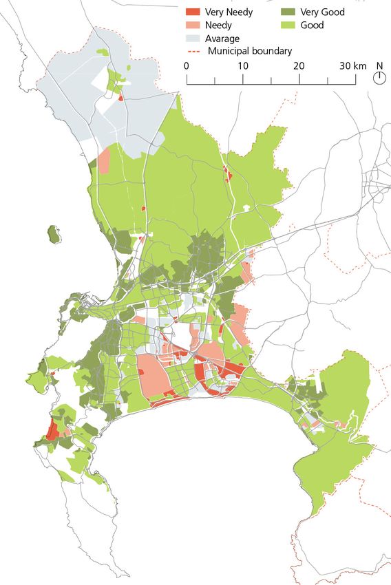
INTRODUCTION     5

and in liaison with the FCO local posts, took the             in a set of City Context Reports as well as an analysis of
lead in identifying stakeholders in a series of bilateral     the technical viability of the interventions. The analysis
meetings, interviews and focal group discussions. This        aimed at both informing the development of the Terms
has collectively gathered information and provided            of Reference and the future implementation phase of
more detailed knowledge and information on the City’s         the Programme.
visions and goals.
                                                              THE CITY CONTEXT REPORT
Based on this initial phase, a Charrette (planning
workshop) involved high-level decision-makers from            Objectives
the public and private sectors together with civil            A City Context Report is provided for each city of the
society representatives. This facilitated discussion on       Global Future Cities Programme. It serves as a tool to
the proposed and possible alternative interventions,          frame the proposed Programme interventions within
related individual interests, technical opportunities and     the characteristics and pre-conditions of each city.
constraints, as well as political objectives. The outcome
of the Charrette provided clarity on where stakeholders       The Report targets a variety of stakeholders in the
stand in relation to the strategic potential of the           Programme: administrators, city managers, policy
discussed projects and it allowed for the mobilisation        makers, legislators, private sector actors, donors, and
of support.                                                   local as well as international researchers and knowledge
                                                              generators. The Reports also provide UKFCO the
At the same time, the Charrette allowed for the technical     contextual setting of each proposed intervention, and
teams to proceed with the development of a Terms of           can in addition, be used by the Service Providers as an
Reference, outlining the specific scope and activities of     entry point for the implementation phase.
each intervention. A final Validation Workshop assured
consensus on the proposed projects and document’s             By addressing the specific challenges facing each city, the
endorsement by the authorities.                               Report illustrates how the interventions can work towards
                                                              inclusive prosperity and sustainable urban development.
Parallel to preparing the Terms of Reference, an              The benefits of each intervention, however, cannot be
evaluation of the interventions was initiated, aiming to      achieved without certain enabling conditions to ensure
address its feasibility within the local strategic context,   its success. Therefore, critical aspects for the delivery
identify potential impact on prosperity barriers and to       of the proposed interventions and its success from a
explore the optimal delivery models. This process resulted    long-term perspective are outlined. Using thematic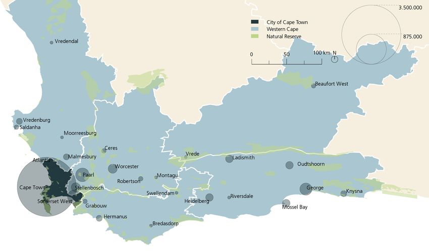
6   CAPE TOWN - City Context Report

    best practices and evidence from global learnings and          can either facilitate or hinder the implementation and the
    research, contextualised recommendations are provided          long-term sustainability of the proposed interventions in
    on the conditions necessary for the intervention to be         transport, resilience and urban planning.
    viable and to reach a maximum impact.
                                                                   This framework follows UN-Habitat’s three-pronged
    Essentially, the City Context Report serves to ensure that     approach, recognising the three essential components
    all actors within the Global Futures Cities Programme          for a successful and sustainable urbanisation: 1. urban
    are aware of the specific conditions to be considered in       planning and design; 2. urban economy and municipal
    the delivery of the proposed interventions, on a case-by-      finance; 3. urban legislation, rules and regulations.
    case basis.
                                                                   Firstly, the spatial analysis describes the existing urban
    Set-up and Scope                                               context specific to the intervention. Urban mobility
    The first part of the City Context Report (General             systems, vulnerability of the built environment, spatial
    Overview) provides an overview of the Global Future            form and trends are considered as possible challenges in
    Cities Programme and introduces the city from the              urban management that the intervention can address.
    perspective of the urban challenge which the proposed
    intervention intends to address.                               Secondly, the financial analysis aims to identify the
                                                                   mechanisms in place by which the intervention could
    The second part of the Report (Urban Analysis) more            be sustainably financed in the long-run. This section
    critically and technically analyses a selection of factors     outlines the city’s municipal capacity, existing regional,
    which need to be considered or to be in place for              national and international financial ecosystem and
    the intervention to succeed, addressing its feasibility,       existing financing mechanisms at the municipal level.
    potential impact on prosperity barriers from a long-term
    perspective.                                                   Thirdly, from a legal perspective, the Report critically
                                                                   analyses how the intervention could be facilitated or
    The third part of the Report (International Alignment          challenged by the vision of the city and its governance
    and Technical Recommendations) presents short–and              hierarchy. Enablers and obstacles resulting from any
    mid-term expected outcomes as well as long-term                relevant legislation, as well as sectoral frameworks
    potential impacts. It further elaborates the contribution      (e.g. strategies, policies, planning frameworks and
    of the intervention to the achievement of the SDGs and         development plans, detailed plans of relevance) are also
    the implementation of the New Urban Agenda as well             described.
    as the programme objectives of the Prosperity Fund.
                                                                   This approach aims to offer implementing partners,
    As the City Context Report is tailored directly to             stakeholders and donors a general context of the city
    the Programme interventions, the analysis does not             and, with it, demonstrate the appropriateness of the
    aim to comprehensively present all aspects of urban            intervention from a spatial, financial and legal point of
    development. It does not elaborate on long term                view, while at the same time informing about potential
    planning and transformation strategies, the effectiveness      barriers and enablers for its implementation.
    of policy or urban legislation, nor the entire municipal
    financial system. As such, it also excludes urban policy       Potential Impact to the Program Objectives and the
    recommendations.                                               SDGs

    However, the Report has the scope to illustrate the            The Report also outlines the potential impact of the
    general capacity of the city for project delivery, and         interventions, based on the specific activities and
    in this regard, make recommendations to support                outputs proposed. Impact can arise from a complex
    implementation of the interventions and reaching set           interaction of context-specific factors, rather than as
    goals. The City Context Reports will be part of knowledge      result of a single action, which makes it difficult to
    management for the Programme to generate local                 empirically quantify longer-run effects that go beyond
    information and data on the cities as well as identify         the identification of program outputs. An empirical,
    gaps in knowledge, systems or governance.                      comprehensive impact assessment is therefore not part
                                                                   of the scope of this report.
    Methodology
                                                                   Nevertheless, the report outlines potential benefits
    Urban Analysis                                                 that are only achievable under certain preconditions
                                                                   and activities. Thereby, short-, medium- and long-term
    The City Context Report provides a general analysis of         outcomes are defined with reference to a project-cycle
    the spatial, financial and legal conditions in the city that   approach, which considers all the project phases from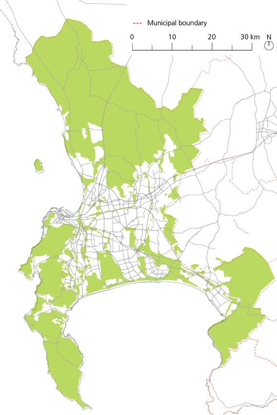
INTRODUCTION      7

                                                            The City Context Reports further connect potential
                                                            impacts to the Programme’s objectives, taking into
                                                            account also the Cross-cutting issues at the core of
                                                            UN-Habitat’s mandate from the UN General Assembly.
                                                            Consequently, the Programme’s objectives are
                                                            summarized into five principles:

                                                            •    Climate Change;
                                                            •    Gender Equality;
                                                            •    Human Rights;
                                                            •    Youth;
                                                            •    Sustainable and Inclusive Economic Growth.

                                                            Cross-cutting issues are addressed with explicit reference
                                                            to the 2030 Sustainable Development Goals (SDGs) and
                                                            the New Urban Agenda, in an attempt to ensure that
                                                            the proposed interventions are in line with the design,
                                                            implementation, review and success of the 2030 Agenda
                                                            for Sustainable Development. Consistent with UN-
                                                            Habitat’s mandate, the SDG 11 Sustainable Cities and
                                                            Communities is linked with the urban dimension of the
                                                            other 16 goals as an essential part of the localisation of the
                                                            SDGs. In this way, interventions can support localisation
                                                            processes, to support local ownership and ensure SDG
                                                            integration in sub-national strategies and plans.

                                                            Technical Recommendations and International Best
                                                            Practices

                                                            The interventions proposed in the various cities of the
                                                            Global Future Cities Programme were grouped into
                                                            clusters according to their thematic entry-point, as an
                                                            elaboration of the thematic pillars of Urban Planning,
                                                            Transport and Resilience.

                                                            These clusters are:

                                                            •    Public space
                                                            •    Heritage and urban renewal
Planning and Design through Building, to Operating and      •    Urban strategies and plans
Maintaining.                                                •    Data systems for integrated urban planning
                                                            •    Multi-modal mobility strategies and plans
Short-term outcomes are directly achieved through the       •    Data systems for multi-modal mobility
implementation of the technical assistance support,         •    Flood management plans and systems
within the 2-3 years scope of the Global Future Cities
Program.                                                    Combining the international experience in urban policy
                                                            and project implementation of UN-Habitat and the
Mid-term outcomes are only realised once the                leading academic research of IGC, each cluster was
intervention is executed through either capital             analysed to offer evidence-based recommendations for
investment, implementation of pilot projects or             a successful Implementation and a maximised impact
the actual enactment of legal documents, plans or           of the intervention. Specific reference was given to
masterplans, within a possible timeframe of 3 to 7 years.   implemented plans and international best practices.

The broader long-term impact of the interventions           The recommendations inform the Planning and Design
is linked to the sustainability of the interventions in a   phase which coincides with the timeframe of the Global
7-15 years timeframe and relates to the operation and       Future Cities Programme, and always aim for long-term
maintenance phase of the project cycle.                     sustainability of the interventions.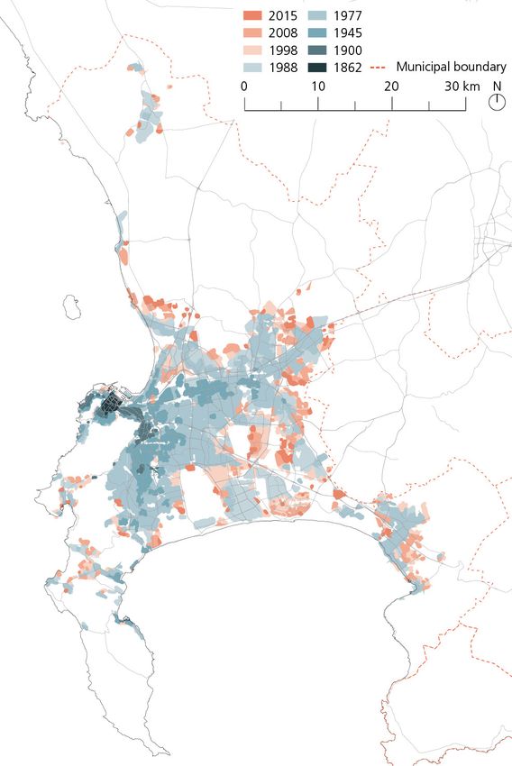
8 CAPE TOWN - City Context Report
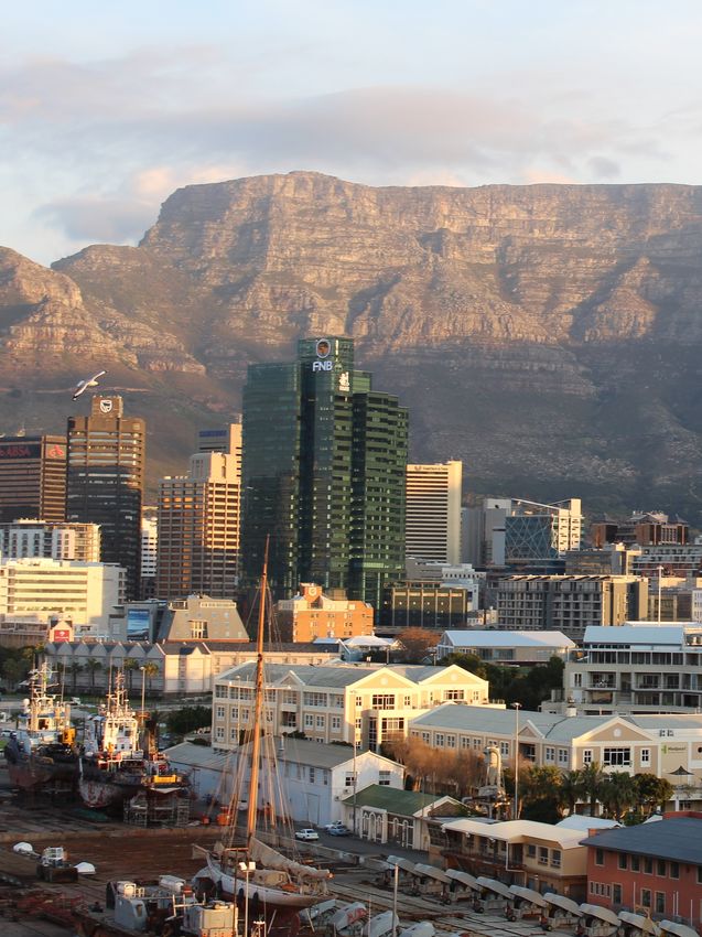
Fig. 1. Table Mountain from City Bowl, Cape Town (Source: pixabay.com)INTRODUCTION 9
C ape Town oldest part and its thriving commercial business district
with a grid-like street pattern founded by the Dutch
East India Company (VOC) in 1652 as a freshwater and
GENERAL OVERVIEW produce supply station for Dutch ships sailing to East
Africa, India and the Far East.
Cape Town is the legislative capital of South Africa1,
hosting the Parliament, and is the provincial capital of The city expands southwards along Atlantic Seaboard
the Western Cape. At the last national census in 2011, towards the Southern Peninsula but its growth is
the population of Cape Town was 3,740,025.2 Based constrained by the mountain range to the east (including
on the latest revision of the UN World Urbanization the famous Table Mountain) and the ocean to the west.
Prospects, Cape Town’s population is currently estimated
at 4,430,367,3 indicating an average annual population Cape Town continues further east to the low-density
growth of 2.4 per cent, much higher than the national neighbourhoods of the Northern Suburbs, Helderberg
one over the same period, 1.5 per cent.4 Like many and the Eastern Suburbs.
South African cities, Cape Town is characterised by low
urban densities of 1,629 people per square kilometre Low-income neighbourhoods are mainly concentrated
(city size: 2 461 km2) at nett density of 17 dwelling units in Mitchells Plain and Khayelithsa, a large township
per hectare. consisting of mostly government housing projects and
informal areas. This zone is also known as the Cape
Although a report compiled by the United Nations found Flats, and was created by the Nationalist Party in the
that Cape Town is the most equal city in South Africa5, 1950s to enforce spatial Apartheid through the Group
like other cities in the country the city is struggling to deal Areas Act of 1950.
with its apartheid spatial legacy, which is characterised
by high levels of unemployment and highly inefficient The city has a high environmental profile but increasing
urban form. urbanisation and climate change make it extremely
vulnerable. The city faces big environmental challenges,
The wealthy neighbourhoods are concentrated in the affected by flooding problems as well a limited access
western part of the City. The City Bowl is Cape Town’s to water.
Fig. 2. Western Cape Province, Cape Town, South Africa district capital by population10 CAPE TOWN - City Context Report
Fig. 3. Western Cape and municipalities by population, and Cape Floral Kingdom Protected Areas highlighted
PROBLEM STATEMENT SUPPORTING THE IMPLEMENTATION OF THE CITY OF
CAPE TOWN’S DATA STRATEGY
In the past two decades, City of Cape Town Metropolitan
Municipality (CCT) has made remarkable progress in The main objective of the intervention proposed by
certain aspects of human development, including access the Global Future Cities Programme is to support
to water, electricity, basic education and healthcare. and supplement the City of Cape Town’s Data
However, a large number of Capetonians still live chronic Strategy, part of the Evidence-Led Decision-Making
stresses such as high unemployment, poverty, crime and Programme (Integrated Development Plan 2017-2022)6,
lack of availability of affordable housing. transforming City data into meaningful and relevant
business information which can effectively support
The City aims to be a forward-looking, resource- decision-making.
efficient and integrated city that delivers quality
services to its residents. To realise this aim, the city More specifically, the intervention intends to:
needs to plan appropriately to respond quickly and • Develop application case study, data quality
effectively to challenges. Data plays a critical role in how standard and metrices to improve data
evidence-based decisions are made and how evidence- collection at various sources
based policies, strategies, plans and implementation • Improved data sharing within CCT and with
programmes are developed. external partners for accurate, evidence-based
strategic planning uses related to each case
The City of Cape Town Organisational Development study
Transformation Plan (ODTP) and Integrated Development • Develop data models, tools and applications,
Plan (IDP) commits the city to enhanced service delivery techniques, capacity and systems for ongoing
objectives through methods including a customer- evidence building and analysis to support
centric model and an operations system that is led by decisions linked to each data and application
strategy and driven by data and evidence. However, case study
there is insufficient technical capacity within the city to • Investigate more integrated outcomes in
inform key decisions around the planning for and design response to the application study fields/
of newer and more integrated data systems (in particular themes that will need co-ordinated planning
big data systems), architecture and infrastructure, and implementation in order to effectively and
including data storage and computing processing for efficiently manage the city’s capital, operational
the analysis of big data. and natural resourcesINTRODUCTION 11
• Improve data security. The resilience assessment
(100RC) of the City of Cape Town identified
a cyber security attack.7 Data security is a top
priority as the City seeks to further advance its
‘open data policy’.
Key outputs of the intervention will be:
Data Capabilities
• Institutionalise data analytics capabilities to
support a data driven and evidence-based
organization, including enhanced economic
analysis.
• Develop capability for Predictive and
Prescriptive, to deliver actionable results,
insights and enhanced outcomes and impacts.
Data Architecture
To build a sustainable and enabling structure that is
Forward Looking and able to support the growing need
for new environments (both internal and external) for
data sharing and analytics, both within CCT and for
external users.
Data Governance
To ensure better quality, more reliable and trustworthy
data and the protection the data assets of CCT.
Data Application Use Cases
Propose data use and application case study data
governance mechanisms in line with the overall Data
Strategy proposals. Areas of focus should be: Main Stakeholder
• Informality
• Transport Data Coordinating Committee (Dcc)
• Resilience (Health and Safety) Organizational Policy And Planning Department
• Human Settlements
• Urban Planning Possible Project Partners
• Asset Management
University of Cape Town, University of the Western
Cape (and other relevant academic partners)
Transport and Urban Development Authority (TDA)
Thematic Cluster
Data System for Land Management and Urban
Planning
Keywords
Data Systems, Planning, Sustainable Mobility,
Resilience, Economy12 CAPE TOWN - City Context Report
URBAN ANALYSIS
travel lengths, low accessibility by poorer communities,
greater use of private vehicles and a sharp rise in traffic
congestion.
Congestion and Land Value Gradients
Traffic, constituting a heavy impediment on travels,
causes intense competition among households and
firms to be located in proximity to employment.
Consolidation of high-end firms, coupled with rising
traffic congestion, is resulting in steepening land value
gradients from the centre to the periphery, which in turn
S patial An a l y si s aggravates income segregation.8
Furthermore, commerce and business tend to choose
sites with location-specific characteristics, such as
URBAN FORM AND SPATIAL STRUCTURE accessibility and proximity to other businesses, despite
their higher price. At the same time, industrial uses,
Historical Context which require larger amount of space, are pushed to
industrial parks on the periphery of the city, where
Cape Town’s growth was structured initially around its land prices are lower. This concentres amenities, good
transport infrastructure, namely the rail lines and road accessibility and safety in economic nodes, while
network towards the south. In the first half of the 20th large-scale mono-functional plots further aggravate
century, the city grew incrementally to the east and fragmentation and declining urban environment in the
intensified within the southern corridor. By the 1950s, outskirts of Cape Town.9
however, Apartheid forced black and coloured residents
to move into segregated dormitory townships on the The city has tried to improve public transport to moderate
periphery of the city and this became the main driver this trend, focusing on Transit Oriented Development
of the city’s spatial form. Densities decreased and the (TOD) strategies,10 in order to achieve market-driven
city saw a rapid sprawl, which persisted in the post- push towards medium- and high-density residential
Apartheid era. areas. In 2016, following the TOD Strategic Framework
adopted by the city, urban development was included
Current Urban Form among the function of the transport authority, Transport
for Cape Town (TCT). This was then established as the
Sprawl and connected disparities have continued as a City’s Transport and Urban Development Authority
general trend despite the more favourable political and (TDA).
planning environment. Low-density, predominantly
white neighbourhoods still occupy the most favourable
locations, while black townships of relatively high
density are placed at the outskirts of the city.
The biggest challenge, common across South African
cities, is the spatial separation between areas of high
population density and areas of jobs opportunities’
concentration, which causes huge numbers of people
to commute daily, at a high cost and a challenge for the
transport infrastructure.
Employment density is concentrated within the city
centre and along the Voortrekker Road corridor in the
north, while the majority of the city’s residential areas
are located in the southeast, the Cape Flats.
The segregated low-density city structure and the
concentrated nature of economic and employment
opportunities result in issues such as long average
Fig. 4. Commercial (in blue), and industrial (in purple) employment density - (Source:
State of Cape Town Report, 2016)URBAN ANALYSIS 13
Fig. 5. Cape Town’s City Bowl Source: (Niina Rinne, UN-Habitat ©)
Atlantis
Northern Suburbs
City Bowl
Atlantic Seaboard Eastern Suburbs
Khayelithsa
Mitchells Helderberg
Plain
Fig. 6. Cape Town’s Socio-Economic Index (Source: Cape Town MSDF 2018-2023) Fig. 7. Cape Town’s historic growth (1862-2015) (Source: Cape Town MSDF 2018-
2023)14 CAPE TOWN - City Context Report
MOBILITY SYSTEM Contracted and Non-contracted Bus System
Cape Town is the most congested city in South Africa11, The network of bus services in Cape Town is entirely
mainly because of a lack of substantial investment in contracted to private companies. Golden Arrow Bus
public transport, and consequent overreliance on private Services is the main operator, with a fleet of 1,010
cars. Cars are the most dominant mode of transport in buses, followed by Sibanye, with 50.16 Companies use
Cape Town, making up 53 per cent of all traffic. Public cash payments but are introducing a smart card system.
transport serves around 38 per cent (mainly train and
minibus-taxi, with a minor component served by BRT Non-contracted buses, mainly minibus-taxi services,
and buses).12 have grown rapidly and are the most widespread
public transport service in Cape Town. It is estimated
The public transport system is extensive but poorly a total of more than 10,000 vehicles to be operating
structured. Local authorities are increasingly involved within the city. CCT requires operators to belong to a
in the planning process but service provision for each registered association but schedules, fares and routes
mode of public transport has been left almost entirely to are completely unregulated, employing a post-boarding,
the various operators. This also reflects on the ticketing cash only, ticketless fare system.
systems, which are different for the various services.
Some 95 per cent of the whole public transport user Non-motorised Transport
group is constituted of poor households, who spend an
average of 43 per cent of their income on it – more than There are 442 km of cycle lanes across the city, some
four times the acceptable international average.13 of which are dedicated cycleways.17 Some cycleways
are clearly demarcated to indicate their location as
Rail System well as the presence of cyclists to motorised transport.
Currently an estimated of 17 per cent of the population
The passenger rail system in Cape Town is run by or more than 500,000 people, only have access to non-
Metrorail for the National Passenger Rail Authority of motorised transport and cannot afford public or private
South Africa (PRASA). Tickets are bought via cash only transport.18 Some 9 per cent of journeys in the city are
at selected stations. covered by walking or cycling.
Historically, rail Is the backbone of the transport system.
However, in the past few years there has been a steep
decline in the number of its users. This is commonly
linked to the deterioration of the service,14 due to lack of 9%
investment and maintenance, together with a spike in
vandalism against both vehicles and key infrastructure.15
12%
This decrease in rail services utilisation is visible in a
corresponding increase of road-based travels, mainly
2%
minibus-taxi and bus services which target a similar
income group. 6%
BRT
MyCiti is a bus rapid transit service with feeders, which 18% 53%
started its operations in 2010. It is managed by the city
and uses a contactless card system for the purchase of
its tickets.
It Is mainly operating along two corridors, connecting
the CBD with the northern area along the west coast, Rail Private
and with Khayelitsha and Mitchells Plain in the south. Contracted bus NMT
Despite this service being relatively new, it is already BRT
Minibus-taxi
subject to increased pressure due to the progressive
decay of the rail system and CCT has extensive plans to
strengthen it.
Fig. 8. Modal split between private, Public Transport (by mode) and NMT (Source:
TDA, Comprehensive Integrated Transport Plan 2018-2023)URBAN ANALYSIS 15
Atlantis
Northern Suburbs
City Bowl
Atlantic Seaboard
Eastern Suburbs
Table Mountain
Helderberg
Khayelithsa
Mitchells Plain
Fig. 9. Main transport corridors.16 CAPE TOWN - City Context Report
Challenges and Strategies once a century has occurred three times in Cape Town
in the last 15 years.20 Extreme events are expected to
The transport inefficiencies are largely due to the become more frequent, with increasing infrastructural
Apartheid spatial planning, with many residents living costs and economic losses.
far from places of work and leisure. Transport challenges
include the peak-hour traffic, the failure of the public Drought is also becoming a major problem, as the severe
transport system, particularly of the Metrorail service, water shortage culminated in the spring of 2018 with a
and the lack of integration between the different public water crisis. Contrary to what this crisis may suggest,
transport modes. the city has one of the best water conservation and
water demand management in the world,21 but the lack
The Comprehensive Integrated Transport Plan 2018- of diversity in supply expose it to the extreme shocks
2023 recognises three key transport trends in Cape that climate change entails. The current drought is more
Town that need to be addressed: severe than a once every 50 years’ event,22 which is the
level planned for by the Department of Water of the
• the deterioration of the rail service in Cape city.23
Town, with its resultant steep decrease in
usage and increase in road usage As such, certain natural assets in the city are identified
• the increasingly-unsustainable cost of transport in the Spatial Development Framework that need
for low-income households protection and where the impacts of development need
• the growing disjuncture between transport to be carefully managed. These biophysical assets include
and land use biodiversity conservation areas, ecological support
areas, coastal areas, agricultural areas of significance,
The delivery of integrated transport is based on the and other sites and landscapes with scenic, recreational
Integrated Public Transport Network (IPTN) Plan 2032. or place-making qualities.
With a multi-modal approach, the IPTN aims to improve
the public transport network premised on BRT and an
expanded rail network. Other key modes include quality
bus and minibus-taxi and they will be complemented by
improved NMT provision.
The city seeks to achieve an integrated, interoperable
and intermodal transport across different modes, and to
lead developmental transformation through TOD, which
will enable residents to live car-independent lifestyles
and enhance access to opportunities.
ENVIRONMENTAL CONTEXT AND RESILIENCE
Natural Assets
Cape Town has a wide range of natural and biological
assets. Table Mountain and Cape Point, heritage areas,
coastal areas and other important cultural landscapes
contribute to a generally high quality of life and a
growing tourism economy. The city is located in the Cape
Floral Kingdom, listed by UNESCO as a heritage side,
which is deemed one of the richest critical biodiversity
areas in the world. However, the impact of urbanisation
and climate change is jeopardising these environmental
resources. Most of Cape Town’s ecosystem is assessed as
endangered or critically endangered.19
Weather events and resource management
Climate change effects have contributed to the more
frequent and intense extreme weather events happened
in the city. Flooding seen as something to be expected Fig. 10. Biophysical assets (Source: Cape Town MSDF, 2018-2023)URBAN ANALYSIS 17
SPATIAL STRATEGIES in figure 11, goes along with the location of existing and
planned rail and BRT stations. Areas within 500m from
CCT seeks to transform itself into a more inclusive, said stations, are defined as Transit-accessible precincts,
integrated and vibrant city that addresses the legacies which should naturally attract investments.
of Apartheid with regard to the built environment.
The 2018 Cape Town Municipal Spatial Development The growth management has identified four primary
Framework (MSDF) seeks to spatialise the visions of the Spatial Transformation Areas:
City’s Integrated Development Plan. • Urban Inner Core - priority area including
commercial nodes and industrial areas, the
Contrary to the previous MSDF (2012), concentrating airport, ports, primary freight infrastructure,
development in two northern expansions, the current integrated public transport network corridors
one seeks to concentrate investment along the existing and transit accessible precincts
corridors within the city. As mentioned before, the plan • Incremental Growth and Consolidation
revolves around land use intensification based on TOD, Areas - areas where the city is committed to
tightly interconnected with the implementation of Cape servicing existing communities and where new
Town’s Integrated Public Transport Network 2032. development will be subject to infrastructure
capacity
Development Corridors for Spatial • Discouraged Growth Areas - areas under
Transformation natural and agricultural protection or lacking
of social and physical infrastructure
Different nodes and corridors form the basis of the • Critical Natural Asset Areas - contributing
spatial form and structure of the city to support land significantly to the city’s future resilience
use intensification areas and the TOD principles on a such as protected natural environments and
citywide scale. The definition of these corridors, shown conservation areas
Fig. 11. Development corridors and existing and Transport-accessible Precints (Source: Cape Town MSDF, 2018-2023)18 CAPE TOWN - City Context Report
2% 1%
3%
31%
Financial Ana l y si s
63%
MUNICIPAL FINANCIAL CAPACITY
The total budget revenue of Cape Town for 2016-17
fiscal year stood at 41.4bn South African Rand - ZAR Service Charges
(approx. 2.9 billion USD). Given the population of Cape Fines
Property Taxes
Town is estimated to be around 3.81m as of 2018,24 this Investments and Interests
roughly equates to a budget of 761 per capita USD. Other Income
Consistent with most municipalities in South Africa, Fig. 12. Breakdown of local resources of revenue (July 2016 - June 2017)
Cape Town relies mainly on own-source revenue to
finance its operations.25 Cape Town generated 80.1 FINANCING MECHANISMS FOR DATA
per cent of its revenue from its own sources, which
represents strong financial independence. The implementation of the City Data Strategy may
require sources of financing for capital expenditures as
The pie chart figure 12 provides a breakdown of the well as for long maintenance. Sources of financing for
own sources. Importantly, about 23 per cent of this these types of systems are usually derived from internal
revenue is generated from property taxes, indicating a revenue from the municipality as it is difficult to raise
strong ability of capturing land value. In line with other associated fees and taxes. Other sources of financing
municipalities in South Africa, service charges from can come from national transfers or grants from
utilities also count for a large share of total revenue. international financial institutions, such as the World
Bank or the African Development Bank, which also have
Besides, Cape Town’s expenditure is principally on an interest in funding such activities.
operations, and less so on capital investments. Operating
Expenditure accounts for 34.545 billion ZAR or about Empowered by the Municipal Finance Management Act,
2.42 billion USD (84.2 per cent) while the capital budget Cape Town has the capacity and precedent to borrow
is of 6.489 million ZAR or 455 million USD (15.8 per domestically and internationally. Most recently, the city
cent). This hints to a difficulty in financing new capital is negotiating of a €80 million (USD 91 million) loan
expenditure investments. from Germany’s KfW Development Bank to upgrade
its wastewater plants.26 Moreover, Cape Town is one
The pie chart in figure 13 provides the outlay of major of two municipalities in South Africa which has issued
expenditure areas. Planning and Development accounts municipal bounds. This further shows a diversity of
for 2.4 per cent of the spending, which could potentially financing options.27
be used to finance a data centre.
Better data and data analysis capacity can result in
This is quite low expenditure compared to other areas higher revenue streams due to the fact that efficiency
such as trading services (48 per cent) or governance (19 improvements can be made in the system. For example,
per cent). On the other hand, most capital expenditures Cape Town is looking to use the financial data from the
are invested in utility services (54 per cent) and transport system to help assess how it can better generate own-
(22 per cent). source revenues as well as to evaluate some of its tariff
structures. Any increases in revenue for the city can be
reinvested in the system. Besides, the city has specificallyURBAN ANALYSIS 19
0.2%
15.7%
18.8%
7.7%
47.9%
54.4%
22.1%
22.2%
2.4%
8.2%
Other Utility Services
Governance Transport
Community Human Settlements
Planning Environment Other
Road Transport Trading services
Fig. 13. Key expenditure areas Fig. 14. Capital Expenditure
highlighted that one of the uses for the data will be to There are, however, specific cost challenges that should
investigate the opportunities for the application of land- be noted, should the city decide to engage with the
based financing instruments in the city. If these are then private sector. The city needs to ensure that the system
implemented as a result of the intervention, there is an and technologies that are recommended are indeed to
opportunity to tap on increased municipal revenues. its advantage and not vested interests of the private
sector. If not, this could result in extremely high costs for
In terms of securing the longevity of the investment, the city that they may not be able to repay. Further, the
there is scope to bring in the private sector. The city will need to ensure it is the owner of the information
private sector can bring in the expertise to analyse and and the system otherwise the private sector company
therefore utilise and ultimately potentially monetise involved may create a monopoly or monetise the data
the data. Additionally, this engagement can enhance to the detriment of the city or the citizens.
improvements in efficiency in the system which can
result in revenue gains.
Cape Town has the legal capacity and the precedent to
enter into PPPs.28 The Municipal Finance Management
Act (2003) and the Section 86A of the Municipal Systems
Act (2000) provide the legal ability for municipalities in
South Africa to enter into PPPs.
Based on these laws, the Minister of Finance and the
Minister for Provincial and Local Government set up
uniform guidelines – known as Municipal Public-Private
Partnership Regulations - for municipalities to follow
while undertaking a PPP agreement.
They can deviate from these guidelines only if the National
Treasury preapproves it. Broadly, these guidelines
establish a framework for the need for feasibility study,
standard procurement measures, amendment to a PPP
agreement and broader contract management.2920 CAPE TOWN - City Context Report
LEGAL CONTEXT FOR SPATIAL PLANNING
While there are national plans that guide municipal
development, the city drafts key local spatial and
development plans, including statutory plans, which
indicates a significant level of devolution of planning in
South Africa.
At the national level, the key plan is the Integrated
Urban Development Framework which is drafted
by the Department of Cooperative Governance and
Traditional Affairs and sets up a broad policy framework
Legal Anal y si s for urbanisation in South Africa. As is required by the
Municipal Systems Act of 2000, CCT has to develop
an Integrated Development Plan (IDP) which is the key
statutory plan. The current one covers the 2017-2022
GOVERNANCE STRUCTURE period which establishes the broad priorities of focus for
the city.34
As defined by the Municipal Structures Act, No.
117 of 1998, CCT is a Category A municipality with Further to this, CPT drafts the Municipal Spatial
exclusive municipal executive and legislative authority Development Framework (MSDF) with the current
in its jurisdiction.30 This provides a clear division of version approved in April 2018.35 The annual Service
responsibilities within different layers of government Delivery and Budget Implementation Plan (SDBIP), also
in all spheres except transport where there is higher drafted by CCT, turns the IDP into tangible projects.36
overlap of competences.
OPEN DATA LANDSCAPE
CCT is governed by a 231-member City Council which
has both legislative and executive authority of the city. There is a significant focus on open data and the usage of
The Council elects the Mayor who oversees the executive data for planning and transport and some infrastructure
branch.31 to that end by CCT. This provides a strong precedent for
further strengthening of smart data at city level.
There is presence of decent coordination mechanisms
between the CCT and the Provincial Government of the At the national level, South Africa is part of the Open
Western Cape, and CCT and the central government of Government Partnership since September 2011
South Africa. However, these are non-statutory, and it which includes encouraging the use of data for public
appears that there are no set publicly disclosed standard innovation.37
operating procedure in relation to data sharing.
Moreover, the City of Cape Town has an Open Data
The central government’s Department of Cooperative Policy,38 put into effect in 2014, which mandates the city
Governance and Traditional Affairs is tasked with to establish a single integrated online ‘open data portal
supporting and coordinating with municipalities across for information and data generated by the organisation
South Africa.32 that is free and accessible to members of the public.39
Presently, there are 37 datasets available.
There is also a statutory autonomous association
of all municipalities which plays an active role in The most extensive use of data for transport planning
intergovernmental relations. For example, it is often is the CCT’s Transport Development Index (TDI). TDI
invited to the Presidential Coordination Council (PCC) identifies the cost of public transport for different
to coordinate with provincial and central government user groups, usually based on their income bracket.40
officials. Moreover, the Western Cape Governments Theoretically, this data is supposed to be used for more
Premier’s Coordinating Forum (PCF) is mandated to inclusive urban planning.
coordinate between the provincial and the municipal
governments.33 WhereIsMyTransport, in partnership with CCT, has
mapped Cape Town’s transport systems, including the
7,500 licensed minibus taxis. The information is available
for usage as an open source for developers and users
through a smartphone application.41 However, the data
is not in real time.42URBAN ANALYSIS 21
Executive Data Coordinating
Managemente Team Committee (DCC)
(ETM)
Data Management Forums / working groups / project teams
(examples will change depending on priorities/needs)
Property Value Chain (PCV) Spatial Information / GIS Organizational Perfor- Informal Settlement
Data Cleansing Workgroup Management Forum mance Reference Group Data Working Group
City Departments
(Data Custodians/Stewards)
Fig. 15. Data Strategy Structure
There is also greater priority for expanding data collection To address current gaps it has been established a
and usage capacity in the city. The priority number (2) Data Coordinating Committee (DCC) responsible for
of the Integrated Urban Development Framework 2017- governance and strategy, together with the introduction
2022 calls for ‘leveraging technology for progress across a Chief Data Officer, responsible for advising on the
the City.’ To this end, Transport and Urban Development organisation on data governance and data management.
Authority (TDA) is establishing an Integrated Information specifically concerning the following three areas:
Management System (IIMS) which would include an
integrated data warehouse with real-time analytics and Improved governance: The development of a CCT data
strategic reporting capabilities.43 strategy; the establishment of clear accountability, roles
and responsibilities for the management of information.
Technology: Ensuring the development of Information
DATA GOVERNANCE Technology platforms and tools to support and enable
the management and integration of City data and
Cape Town’s IDP, under its Evidence-Led Decision- information and data (also addressing issues of usability)
Making Programme,44 identifies digital tools as key Content: Setting in place policies, guidelines and
assets required to support business processes, planning, Standard Operating Procedures (SOPs) for the
management and compliance and outlines a Data management of City data and information content
Strategy to make the large volumes of data generated
and held by the city accessible and available to inform
decision-making and planning. This committee has overseen the development of the
Data Strategy and is providing oversight to the plan
This project aims to address current gaps in data tools of action to address the current challenges the city is
and analysis, building the city’s capacity to analyse, experiencing.
package and distribute data as a basis for decision-
making
The Data Strategy identifies a siloed approach to
the collection, storage and use of data by various
departments which the CCT, along with absence of a
single agency of ownership as hindrance to achieving
smart usage of data.22 CAPE TOWN - City Context Report
INTERNATIONAL ALIGNMENT AND
TECHNICAL RECOMMENDATIONS
Potential Impa c t
The potential impact analysis outlines the main benefits Moreover, through the Data Application Use Cases,
that can be potentially attained through the Global the Municipality will have the potential to identify
Future Cities Programme in Cape Town, in the short-, and develop specific data-based innovative projects to
medium- and long-term. Nevertheless, as impact can address urgent urban issues.
arise from a complex interaction of context-specific
factors, rather than as result of a single action, an In the mid-term, the intervention will strengthen the
empiric impact assessment is out of the scope of this data governance of CCT, enabling the capacity to
report. produce, process and exchange data from different
sources, both public and private. These will lead to a
The short-term work refers to the outcomes that can be better coordination and cooperation between different
achieved through the implementation of the technical municipal departments and levels of government, as
assistance support within the 2-3 year scope of the well as enable the private sector to be more effectively
Global Future Cities Programme. Mid-term outcomes are engaged and involved.
only achievable once the intervention is executed at the
city level either through capital investments or the legal Furthermore, the intervention has the potential to provide
validation of key polices and plans. Long-term impact to citizens, both from the public and the private sphere,
of the interventions is linked to the sustainability of the the instruments (data architecture and governance) and
interventions in a 7-15 year timeframe and is related to the capacity (Data Capabilities) to access, visualise assess
the project cycle phase of operation and maintenance. and share the information related to urban governance.
The transparency and accountability of the municipality
will increase and the direct and indirect contribution of
several society groups will be promoted.
SHORT-TERM OUTCOME
In the short term, the Global Future Cities Programme’s MID-TERM OUTCOME
support to the implementation of the City of Cape
Town’s Data Strategy will positively impact the municipal The intervention promotes a strong attention to the
technical and managerial capacity whilst increasing collection of data related to the most vulnerable society
citizens’ access to information and communications group - women and low-income communities - through
technology. the direct contribution of NGOs or communities’
associations and communitarian inclusion. This will
With its first components, the intervention will build help with integrating gender equality approaches
capacity within the municipality (Data Capabilities) and into policies, strategies and plans. Data use and
provide better data availability (Data Architecture and application case studies should create transparent visual
Governance). The improved accessibility to statistics on monitoring tools supported by easily accessible datasets,
demographic, economic, environmental and social issue contributing to a culture of transparency and evidence-
will allow an evidence-based decision process. At the based decision-making.
same time, it will be possible to achieve an enhanced
analysis with monitoring and evaluation of plans, In the mid-term, all of this will produce integrated
policies and strategies. plans, frameworks and approaches to promote more
sustainable, resilient, and socially-inclusive urbanisation,INTERNATIONAL ALIGNMENT AND TECHNICAL RECOMMENDATIONS 23 including the monitoring of environmental risks and the implementation of climate change adaptation and mitigation measure. Finally, the emphasis given to economic analysis, to better utilising data for economic modelling, empirical evaluation, spatial planning and cost benefit analysis will provide the ability to plan for inclusive economic growth in a sustainable, climate smart manner. LONG-TERM POTENTIAL IMPACT The long-term impact of the intervention concerns a broad range of urban and social issues and represents the frame where the development of the Data Governance Framework, combined with the Urban Information Hub and the Data Engagement Plan, expresses its potential. The possibility of accessing and comparing data regarding urban, transport and natural environment can lead to monitoring the current city plans and to improving their quality for future city strategies. Land use and transport could be coordinated towards the transit-oriented development pursued by the city, optimising density, mixed use and efficient urban development, where the provision and distribution of basic services will be based on a clear knowledge of urban needs and gaps. At the same time, better integration of the transport network can then reduce the traffic congestion and reduce air pollution. The city will have improved tools to protect its environmental heritage and increased planning, monitoring and forecasting capacity to respond to environmental risks. The ability of the city to respond to the harmful threats of climate change and increasing frequency of extreme shock events will be enhanced, protecting Cape Town’s inhabitants especially its vulnerable communities. The increased evidence-based awareness and the improved administrative control of urban, social and environmental data will allow for a more efficient and sustainable financial urban management. The intervention has the potential to improve the city’s capacity to optimise and reduce public expenses and to strengthen municipal finances and increased municipal capacity for revenue.
24   CAPE TOWN - City Context Report

                                                                      migratory status, disability, geographic location and
                                                                      other characteristics relevant in national contexts” (SDG
                                                                      17.8). This data use will lead to an improvement and
                                                                      strength city policies to “enforceable legislation for the
                                                                      promotion of gender equality and the empowerment of
                                                                      all women and girls at all levels” (SDG 5.c).

                                                                      INNOVATION, INFRASTRUCTURE AND
                                                                      JOB OPPORTUNITIES

                                                                      The Engagement Action Plan can also significantly
     C o ntributi on t o Sust a i n a b le                            increase access to information and communications
                                                                      technology (SGG 9.c) and “promote development-
     U rban D ev el op men t                                          oriented policies that support productive activities, of
                                                                      ICT related job creation, entrepreneurship, creativity
     2030 SUSTAINABLE DEVELOPMENT GOALS                               and innovation and encourage the formalization and
                                                                      growth of micro-, small- and medium-sized enterprises,
     The Global Future Cities Programme aims to contribute            including through access to financial services” (SDG
     the implementation of the 2030 Agenda for Sustainable            8.3).
     Development, whilst mobilising efforts to end all forms
     of poverty, fight inequalities and tackle climate change
     while ensuring that no one is left behind.
                                                                      INCREASED RESILIENCE

     INCREASED                                                        The intervention’s objectives will be aligned to the goal
     ACCOUNTABILITY                                                   of promoting a more environmentally-sustainable urban
                                                                      development and integrate climate change measures
     The implementation of the City of Cape Town’s                    into national policies, strategies and planning (SDG
     Data Strategy will enhance inclusive and sustainable             13.2). The Data Strategy implementation would allow
     urbanisation through a responsive, inclusive, participatory      better monitoring, report and forecast processes of
     and representative decision making at all levels (SDG            climate events that need to be faced with an effective
     16.7). The participatory process and the community               climate change-related planning and management
     involvement in several sectors of public life will allow         (13.b), ensuring also the conservation of the Cape Floral
     a stronger monitoring and evaluation process on the              Kingdom and its invaluable ecosystems (15.1).
     public administration, leading to the establishment of
     more accountable and transparent institutions at all
     levels (SDG 16.6).
                                                                      BASIC SERVICES, SUSTAINABLE
                                                                      CITIES AND COMMUNITIES
     INCREASED MUNICIPAL                                              Finally, an evidence-based urban governance can
     REVENUE                                                          improve the provision of urban services such as
                                                                      transport system (SDG 11.2), water and sanitation (6.1,
     With better quality and more relevant data for economic          6.2), waste management (11.6), energy (7.1) and public
     analysis, the intervention will assist the city in application   spaces (SDG 11.7), making them more accessible, safe
     of economic modelling to spatial planning and cost               and affordable for all. Special attention will be given to
     benefit analysis, improving municipal spending and               the needs of vulnerable groups such as women, children
     revenue generation (SDG 17.1).                                   and persons with disabilities (1.4).

     GENDER EQUALITY AND
     INCLUSIVITY

     Moreover, the data architecture and data governance
     component of the intervention will “increase significantly
     the availability of high-quality, timely and reliable data
     disaggregated by income, gender, age, race, ethnicity,
You can also read