The Christchurch Waterways Story - Robert H Watts - Landcare Research Science Series No. 38
←
→
Page content transcription
If your browser does not render page correctly, please read the page content below
The Christchurch
Waterways Story

Robert H Watts

        Landcare Research Science Series No. 38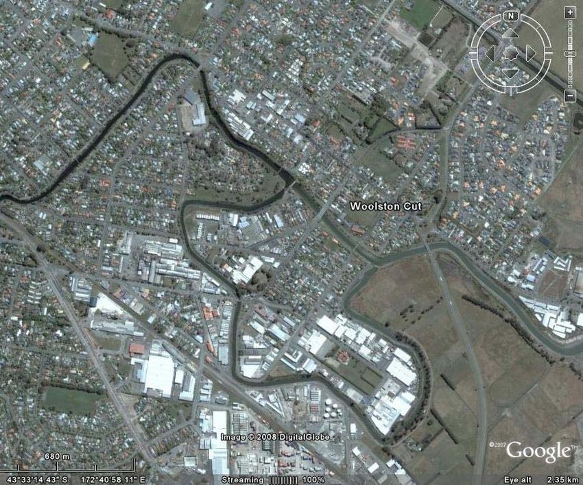
The Christchurch Waterways Story

              Robert H Watts
                   MIPENZ

 Landcare Research Science Series No. 38

        Lincoln, Canterbury, New Zealand
                     2011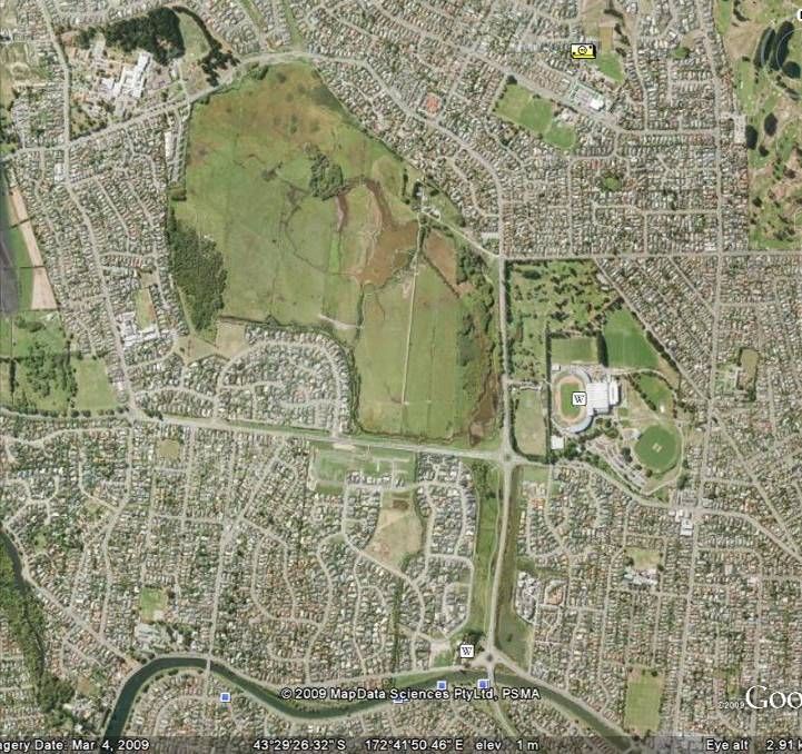
©       Landcare Research New Zealand Ltd 2011
Robert Hugh Watts asserts his right to be identified as the author of this work in accordance with
section 96 of the New Zealand Copyright Act 1994

This information may be copied or reproduced electronically and distributed to others without
limitation, provided Landcare Research New Zealand Limited is acknowledged as the source of
information. Under no circumstances may a charge be made for this information.

Disclaimer
Points of view or opinions in this report are those of the author and do not necessarily represent the
official position or policies of Landcare Research New Zealand Ltd. Landcare Research accepts no
responsibility for any errors, omissions, or inaccuracies in the information in this report, nor will
Landcare Research be liable for any loss or damage suffered as a result of reliance on this
information, or through directly or indirectly applying it.

CATALOGUING IN PUBLICATION
Watts, Robert H.
 The Christchurch waterways story / Robert H. Watts. -- Lincoln, N.Z. : Manaaki Whenua Press,
Landcare Research, 2011.

 (Landcare Research science series, ISSN 1178-3419 (online) ; no. 38)
 ISBN 978-0-478-34712-8 (online)

 1. Stream conservation -- New Zealand -- Christchurch. 2. Restoration ecology -- New Zealand --
Christchurch. I. Manaaki Whenua-Landcare Research New Zealand Ltd. II. Title. III. Series.

UDC 504.453.062(931.322.6)

The images on pages 8, 12, 23, 25, 26, 27, 28, 31, 34, and 39 are reproduced with kind permission of
Christchurch City Council’s Network Planning, Greenspace Unit

The image on page 7 is reproduced with kind permission of Canterbury Museum

Edited by Christine Bezar
Cover design by Anouk Wanrooy

Published by Manaaki Whenua Press, Landcare Research,
PO Box 40, Lincoln 7640, New Zealand
1

Foreword

Christchurch was ‘Leader of the Pack’ through the 1990s in terms of grasping the fundamental
meaning of the internationally ground-breaking resource management legislation. Through a series of
fortuitous events the Christchurch Drainage Board, which had for over a century dedicated itself to
the task of squeezing every drop of surplus water out of the city – for purposes of sanitation,
development and gardening, was transformed into a force for recognising water as ‘your friend’. This
‘force’ was the newly amalgamated, greater Christchurch City Council’s Water Services Unit. With
the old guard retiring, a group of innovative engineers appeared, blinking as they emerged from their
piped surrounds into the sunlight. This band of big thinkers embarked on the creative mission of
freeing the city of its linear manicured mind set and instead introduced serpentine tussock-clad river
banks, havens for native wildlife. Importantly, they implemented a multi-value approach to water
planning in the city and for a while the concept, the indigenous plants and the wildlife flourished. And
at about the time the rest of the country, which had been sending scouts down to Christchurch to view
these new ideas, started to reinvent them in their own cities, Christchurch succumbed to a suffocating
backlash from reactionary but influential citizens and politicians. Although there was an unfortunate
check in the progressive developments, the spirit had been released from its Victorian straightjacket,
and certainly the rest of the country began to take on the ideas as though they were the norm. The
news is out, most people love the naturalistic riverbanks with their distinctive tall-tussock sedges,
bellbird-attracting harakeke, and the kaikōmako that is flowering for the first time in a long time –
beside the Avon River.

There have been books about the amazing emergence of a city from a swamp and the important
engineering works that allowed this to happen. But there is a new chapter in this fascinating story to
tell and who better than Robert Watts (one of those intrepid pioneers of sustainable, multi-value water
management) to help us understand how the city has refounded its swampy past but in a tamed and
constructive way – so that nature and culture can coexist and each can inform the other. So we can
have a point of difference from the rest of the world and from the rest of New Zealand. All cities are
eco-cities; Christchurch is much more than a narrow definition of a garden city. It is nature’s garden –
an urban forest of native and exotic trees and shrubs that together personify the integration of
historical stages and the hybrid vigour that results from this dynamic fusion.

Colin D Meurk
12 November 2009
2
3

Contents

Preface ........................................................................................................................................................ 5

Part One:          The Christchurch Drainage Board – keeping folk dry and healthy.............................................. 7

Part Two:           Some influential early milestones ........................................................................................... 9

   The Woolston Cut – an environmental disaster but a new beginning................................................................ 9
   Brooklands – the first site‐sensitive design ...................................................................................................... 13
   Corsers Stream, Travis Swamp and Anzac Drive – saving waterways and wetlands by reversing
   past decisions ................................................................................................................................................... 15
   The Avon River / Ōtākaro, Central City – a small but significant departure..................................................... 19

Part Three:            Vision to Reality pathways................................................................................................. 20

   Waterway Enhancement Programme – restoring our natural heritage .......................................................... 20
   The City Plan – getting the law on the right side.............................................................................................. 22
   Waterways and Wetlands Natural Asset Management Strategy – the big picture ......................................... 23

   Avon River / Ōtākaro, through the suburbs – the six values at work ............................................................... 29
   Stream and street renewal in Papanui – a silo‐busting initiative ..................................................................... 30

   Planning protocols and the South‐West Area Plan – getting in at the start .................................................... 32
   The Styx Vision – a great legacy in the making ................................................................................................ 34
   Waterways, Wetlands and Drainage Guide – a DIY reference for all............................................................... 36

Part Four:         The people and reflections – a philosophical summary ........................................................... 37

Bibliography .............................................................................................................................................. 40

Appendix 1             Explanation for waterway setback rules............................................................................. 41

Appendix 2             Visions and strategies for Christchurch City ........................................................................ 43

Appendix 3             Joint CCC/ECan Planning and Consents Protocol for Surface Water Management ............... 50

4
5

Preface

One of my earliest memories is of standing by a pond full of aquatic plants and surrounded by lush
vegetation, that was being traversed by a large dragonfly with colourful wings that glistened in the
sunlight. Since then I have always been excited by watery landscapes and the life they contain.

Twenty years later, as an assistant civil engineer in Auckland, I was asked to supervise the cleaning
by dragline of an urban waterway. The removal of waterweed was intended to ensure that storm flow
capacity was maintained. The aquatic plants were dumped beside the waterway together with
entrapped fish and invertebrates. It seemed to me that I had been involved in something
fundamentally bad. The waterway had already lost most of its riparian environment and pristine water
quality, and now it was losing its life.

Today, the adverse impact that cities have on surface water is a worldwide issue.

No doubt you, like me, have been moved to ask: Why is it not possible to develop settlements in a
way that protects our natural water environment? Whether you said it quietly to yourself or loudly to
someone else, you think it should be possible, prompting a further question: How does one go about
achieving it? My opportunity to make a start came twenty years ago when I was appointed Planning
Manager in the Drainage and Waste Management Unit of the then new Christchurch City Council.
Since then the management philosophy of surface water in Christchurch has changed from a single-
focus, land drainage approach to one that responds to all its values. These values are identified as:
ecology, landscape, recreation, heritage, culture and drainage. This change involved people with
vision and energy who were able to translate into physical reality our society’s desire for quality of
life and quality of the environment.

Relating the story of how the change occurred is intended to encourage others to make the most of
their local surface water environment. It tells how progress was made, who was involved, and what
organisational changes and relationships were established.

The story begins with the 100-year-old Christchurch Drainage Board and its legacy. Part Two
describes influential milestones on the path to change, and Part Three, how change was implemented.
At the end of the story a philosophy emerges for the sustainable management of urban surface water
environments.

I have written this story at the request of those involved in guiding the Low Impact Urban Design and
Development research project1 at Landcare Research, Lincoln.

Robert Watts
2010

1
    http://www.landcareresearch.co.nz/research/built/liudd
6

Postscript

This story was written before Christchurch was struck by a series of devastating earthquakes that
began in September 2010. The likely impact of an earthquake on the city’s land drainage
infrastructure was assessed as part of an engineering lifelines study. The report entitled: ‘Risks and
Realities: A Multidisciplinary Approach to the Vulnerability of Lifelines to Natural Hazards’ was
published by the Centre for Advanced Engineering, University of Canterbury in November 1997. Not
including a reference to this study in The Christchurch Waterways Story was an oversight on my part.
I will leave it to others to compare predicted with actual ‘risks and realities’. Such a comparison is
likely to influence the proximity of future buildings and urban boundaries to waterways and wetlands.

A more recent study by Environment Canterbury assesses the ecological impact of the earthquakes on
Christchurch waterways and its estuary.

Robert Watts
September 2011

Author Information

Robert Watts, Member Institution of Professional Engineers, New Zealand, completed this report
while working as an environmental researcher at Landcare Research 2008—2010.
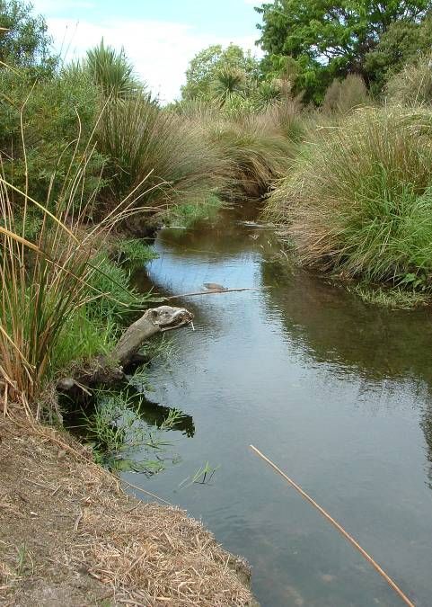
7

Part One: The Christchurch Drainage Board – keeping folk dry and
healthy

The first British settlers of Christchurch were able to make use of an abundant supply of artesian
water and a natural system of waterways for transport. Over time, as the population of the settled
areas grew, waterborne diseases, high groundwater levels and flooding became serious problems. In
due course the Christchurch Drainage Board was established (in October 1875) and given the dual
tasks of land drainage and wastewater management. Fortunately, the Board engaged an experienced
civil engineer from London, William Clark, who advised the Board to construct separate foul water
and stormwater sewers.

The market place, Christchurch 1859 (Dr A C Barker, Canterbury Museum) Permission of Canterbury
Museum, Christchurch, New Zealand must be obtained before any re-use of this image.

During its more than one hundred year existence the Board constructed many hundreds of kilometres
of open drains, concrete- or timber-lined channels, and pipelines. It progressively deepened, widened
and straightened the Avon, Heathcote and Styx rivers. Low-lying riverside neighbourhoods were
8
protected from flooding by the construction of stopbanks and local area pumping stations. The cost of
replacing this stormwater infrastructure is estimated to be half a billion dollars. All this activity
created land upon which an English style ‘Garden City’ could grow.
While the main focus of the Board was on flooding and public health, in its latter years there was also
concern for aquatic life. The Board’s Biologist and Trade Waste Inspectors improved public
awareness of the connection that the stormwater system had with natural water and the need to avoid
pollution.
In the 1980s issues relating to local government reform, wise resource management and the
environment were to the fore. Planning staff at the Christchurch Drainage Board had already begun to
think about such issues as more and more people expressed concern for the continual loss of natural
values associated with surface water. At this time also there arose a growing expectation that the
Board, with its narrow, constraining responsibilities, would be replaced.
Members of the Christchurch Drainage Board and visitors present at the opening of the septic tank,
Bromley, 4 September 1905 (CCC NPGU)
A short history of the Board and a guide to further reading may be found on the NZine website2.
2
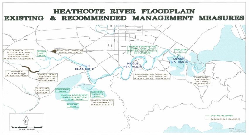
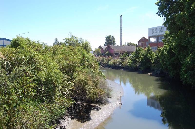
http://www.nzine.co.nz/features/swamp_city1.html9 Part Two: Some influential early milestones The following are the important events that marked the progress of thinking away from reliance solely on engineering solutions and towards finding space upon the urban landscape for protecting and emulating nature. The Woolston Cut – an environmental disaster but a new beginning Many hundreds of properties lie on the Heathcote River floodplain. Flood studies undertaken in the 1980s and an assessment of likely flood damage indicated that up to 60 homes and some 200 garages would have water inside them if urban development continued to expand within the catchment. The extent and frequency of flooding alongside the lower reaches of the river was reduced following the commissioning of the Woolston Cut by the Christchurch Drainage Board in 1986. ‘The Cut’ is a wide concrete-sided channel that allows flood flows to largely bypass a long, narrow meander in the natural river channel. The work was seen as a necessary first step to enable channel enlargement work to be undertaken along various reaches of the river upstream. The lower Heathcote River / Ōpāwaho showing the Woolston Cut. The undeveloped land in the bottom right is flood prone
10

The Woolston Cut was planned against a background of historical flooding that residents of riverside
neighbourhoods found distressing. The motivation to do something to reduce flood levels is high
when a community witnesses people, especially the elderly, being evacuated from their flooded
homes in bitterly cold weather. Strong damaging winds and the gorging of sanitary sewers added
further misery to residents of flood-affected areas.

In 1989 the Christchurch Drainage Board’s organisation merged with a new, larger Christchurch City
Council as part of local government reform.

At the same time, the environmental effects on the Heathcote River upstream of the Cut were
beginning to give rise to new concerns. Extensive slumping of banks and the death of a few of the
more susceptible riverside trees had occurred. A full investigation was initiated.

The environmental damage arose from tidal backflow up the Cut bringing saline conditions to a
previously freshwater zone. It was a change in soil chemistry that caused loss of soil cohesion and
consequent instability of the riverbanks. This effect was compounded by the activities of a burrowing
crab that migrated upstream from the Avon–Heathcote Estuary. In addition, tree death was increasing
as tree roots translocated more salt to the trees with each tide cycle.

Residents of riverside neighbourhoods were angered by the dramatic loss of their treasured river
environment. They rejected an adaptation approach, i.e. one in which the emerging estuarine
conditions are accepted and the banks stabilised with salt-tolerant native plants. The solution
eventually adopted was to construct a barrage at the upstream end of the Cut. The radial gates on the
barrage are normally closed, so that tidal movement is returned to the original meandering river
channel, and opened only for flood flows. A bank restoration and tree planting programme followed.

The Woolston Barrage
11

The Woolston Cut looking
downstream from the barrage,
2008

Looking upstream of the Cut at
tree restoration alongside the
Heathcote River, 2008

The Woolston Loop meandering
through Christchurch’s historical
industrial area. Because of the
Cut, the Loop is no longer a
constriction to flood flows so
natural and assisted restoration is
now taking place
12

                                                                                          (CCC NPGU)

The adverse environmental impact of the Woolston Cut gave rise to a determination by both
community and Council to seek ‘non-structural’ approaches to flood mitigation. Further flood studies
were undertaken and the Heathcote River Floodplain Management Strategy (above) was subsequently
produced and adopted jointly by the Canterbury Regional Council and the Christchurch City Council
in 1998.

The Strategy places emphasis on reducing flood damage rather than flood levels and planning
measures rather than physical works. Within the upper catchment large areas of natural ponding are to
be protected. Consents are to be sought for improving their detention storage and for the infiltration of
stormwater in areas having pervious soils and low groundwater levels.

No further engineering works will be undertaken on or alongside the Heathcote River. The margins of
the river are now being managed as a linear park with emphasis on ecology, landscape, recreation,
heritage and culture. Channel modification will only occur to allow ecological water’s edge planting
to be done in a way that avoids flow restriction.

The Woolston Cut experience brought engineers and ecologists together at a time when the country as
a whole was discussing environmental issues and resource management law. This period was the
beginning of a movement to manage the city’s surface water system for all its values. For anyone
interested in the effect of sea level rise on small coastal rivers, the Woolston Cut experience would
provide a useful study.
13
Brooklands – the first site-sensitive design
Brooklands is noteworthy because it was the first part of Christchurch where non-conventional
planning and design approaches were pursued. This was done in order to address significant natural
hazard and natural environment issues. It involved integrated stormwater and street design, and
collaboration with land-use planners.
Brooklands is a small settlement located in the north-east corner of the City’s district. The land is low-
lying with groundwater levels rising close to or above ground surface following periods of prolonged
rainfall. The Waimakariri River to the north, the Styx River to the west, and Brooklands Lagoon to
the east, make it a hazard-prone location.
Waimakariri River
Brooklands
Styx Lagoon
River
© 2009 Google
Brooklands: set amidst ground and surface waters
Although the settlement was already subdivided, prior to 1990 only about a third of the lots had
dwellings on them and further building was prevented due to water-related human health concerns. To
allow further development, the provision of sewerage, reticulated water supply and street
improvements together with surface and groundwater management was going to need to be funded by
the wider Christchurch community.
The effect of sea level rise on the area was a matter of concern. The coastal dunes, the river mouth,
the lagoon and surrounding wetlands would, over time, become significantly altered. The settlement
would be subject to tidal inundation and eventually, if the dunes became eroded, direct attack by
ocean waves.
The following question was asked: If sea levels are going to rise is it sensible to spend public money
on providing infrastructure that will allow many more houses to be built? At that time (1990) sea level
rise was highly controversial and although an important issue for the country as a whole, a National
Coastal Policy Statement on the matter did not exist. Should a stand have been made? Only
time will tell!14
Roadside swales with subsoil drains: a
system that collects and cleans stormwater
and controls groundwater levels
Instead, a surface and groundwater management system was devised that provided roadside grassed
swales with continuous perforated pipes below the swale invert. Individual properties have their roof
stormwater connected to a soakage chamber located close to the street boundary.
City Plan changes were needed to help retain the rural character of the settlement, protect natural
habitat and reduce future flood damage.
Under the new rules the minimum lot size for future subdivision was set at 1000 square metres. Lot
and floor levels were set that included an allowance for a 400-mm rise in sea level. Residential land-
use boundaries were modified to prevent development from occurring on dunes and saline wetlands.
The planning process recognised the special character of Brooklands and today it has many more new
houses on both existing lots and new subdivisions. It has proved to be a popular place because of its
rural character and natural surroundings.15
Corsers Stream, Travis Swamp and Anzac Drive – saving waterways and
wetlands by reversing past decisions
A large area of low-lying land north of the Avon River / Ōtākaro was originally zoned entirely for
residential use. A valuable existing wetland covering part of the area was subsequently saved and
green corridors to the Avon River / Ōtākaro created as part of residential development and
expressway construction.
Travis Swamp
Anzac Drive
green corridor
Corsers Stream
Avon River /Ōtākaro
©2009 Google
Travis Swamp and its connections to the Avon River / Ōtākaro
Corsers Stream – a piping plan that changed to a pipe dream, then reality
Corsers Stream began life as a rural utility drain within low-lying paddocks north of the Avon River /
Ōtākaro. Its main function was to drain groundwater. Tidal backflow from the river was prevented by
a hinged tide-gate.
To satisfy district plan provisions for residential land use, in this area existing ground levels needed to
be raised with filling by about one metre. It was proposed to replace the open drain with a large-
diameter pipeline. The 5.4 million dollar (1988) cost of the pipeline was to be cost-shared by
developers within the catchment, with the Christchurch Drainage Board acting as banker.16
The scheme was reviewed after amalgamation, by the new Christchurch City Council, for the
following two reasons:
(1) The Council intended to purchase that part of the land within the catchment known as Travis
Swamp in order to protect and restore its natural values. This involved lengthy negotiations with the
owners, who had the right to fill and develop the swamp for residential use under the Waimairi
District Plan. The purchase was eventually achieved, but not before a drainage scheme needed to be
adopted to provide for ongoing development in other parts of the catchment.
(2) The sequence of development meant significant financial outlay by the Council on the pipeline at
the downstream end but with a long period before receiving financial contributions.
A new scheme was prepared. It proposed that Corsers Drain be naturalised within a corridor of land in
Council ownership. The first stage of the work involved the purchase of six lots of a recently
approved subdivision. As the Council had no experience with such a project, the option of piping was
kept open as a backup should the naturalisation work prove to be unsatisfactory. Fortunately, it was
very successful.
Corsers Stream: designed with generous capacity for both storm flows and vegetation
The naturalisation of the drain continued for the full length of the original piping scheme, with the
support of all the developers. The advantages of the scheme compared with conventional piping were
significant and included:
• Lower cost – about two-thirds that of the original piping scheme
• The provision of a public walkway alongside the waterway
• The creation of a ‘green corridor’ linking Travis Swamp with the Avon River
• An attractive outlook for adjoining properties
• A flatter hydraulic gradient allowing lower fill levels and consequent cost savings
Perhaps the most significant advantage was the ability to demonstrate the many benefits of waterway
naturalisation and restoration within a corridor in public ownership. In the case of Corsers Stream,
most of the land was obtained as reserve contribution from the developers.17 Travis Wetland Nature Heritage Park – a planning mistake that ended in triumph The following is an extract from the website of the Travis Wetland Trust. ‘Travis Wetland is located in north-east Christchurch, close to sea-level, and is typical of pre-European Christchurch and Canterbury plains swamp lands. 1600 years ago it was an estuary similar to the Avon/Heathcote Estuary of today. A sandbar gradually shut out the sea, decreasing salinity and allowing wetland plants to take over from salt marsh species. Travis is the largest freshwater wetland in Christchurch with an area of 120 hectares. Māori history of Travis wetlands Travis Wetlands were one of the mahinga kai (traditional resource gathering areas) and used by Waitaha from about 900AD, Kati Mamoe from about 1600, and by Ngai Tahu from about 1650. Queen Elizabeth II Park now occupies the land (known as Oruapaeroa) that was the residential area for the families of Ngai Tahu who harvested these wetlands. Eel, fish, kereru, raupo seeds, and other wildlife were in abundant supply. Harakeke was used for weaving baskets, clothing, and roofing, and raupo was used for thatch. In the mid 19th century the whare of Oruapaeroa were still standing but were burnt down in 1862 when a European settler gained crown grant of the land. Māori had requested that this ancient pa site be excluded when Kemp’s Purchase of 1848 was drawn up, but this did not happen. Only a decade ago, these wetlands were grazed by cattle and looked like becoming yet another housing development. The Travis Wetland Trust lobbied the Christchurch City Council to step in and buy the land, which they did in 1996. Travis Wetland is an important site for local and regional conservation of wetland plants.’
18

Travis Swamp: a diversity of wetland habitats (2008)

Anzac Drive Corridor
Planning for the New Brighton – Burwood Expressway resulted in the purchase of several large lots
of privately owned undeveloped land. The intention was to later sell the land that would be surplus
once the expressway had been designed and its overall width and position determined. A newly
appointed landscape architect (the first ever in the land drainage team) saw the opportunity to design a
multi-purpose green corridor. Concept plans were prepared in collaboration with road designers, land-
use planners, an ecologist, drainage engineers and adjoining landowners. City councillors responded
very favourably with one councillor saying that this was the kind of integrated planning they hoped
would occur following local government amalgamation.

Anzac Drive: a green corridor and a glimpse of a pre-settlement landscape
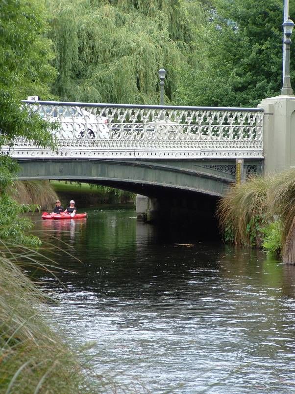
19

The Avon River / Ōtākaro, Central City – a small but significant departure

The margins of the Avon River through the central city have been the favoured location for many fine
buildings and public gardens. Important community assets include the Canterbury Provincial
Chambers (pictured below right), the Christchurch Town Hall, the Central Library, the Municipal
Baths and the Law Courts together with several charming Victorian bridges, Victoria Square and the
Botanic Gardens. They are testimony to how influential an attractive natural waterway within public
land can be on the quality of the surrounding built environment.

In recent times the natural water’s edge vegetation has been allowed to grow, rather than be cut back,
in order to provide invertebrate habitat and shelter for fish. Initially, there was comment that the well-
groomed banks had become scruffy, but in time people got used to the different look.

The practice of excavating areas of shoaling has also ceased in favour of planted shallows.

These small but significant changes mean that all of the six values, i.e. ecology, recreation, landscape,
heritage, culture and drainage, are now present right through the heart of the City.

The Avon River / Ōtākaro: A pleasing blend of natural and built environments
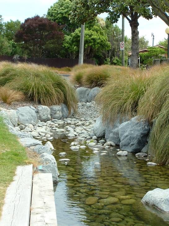
20

Part Three:              Vision to Reality pathways

In 1989 the new Christchurch City Council was formed from the amalgamation of the Christchurch
Drainage Board and several existing district councils. This reorganisation, together with the Council’s
new statutory responsibilities, was a great opportunity to take a fresh, comprehensive look at surface
water management. The events described in Part Two provided the kind of experience that was
needed for this task. The work was not undertaken as a logical, well-planned series of steps. Rather, it
meant being influential when decisions needed to be made relating to staff recruitment, budgeting,
district plan preparation, operation and maintenance contracts, design standards, asset management,
land acquisition, organisational structure and relations with key stakeholders. Justifying the adoption
of a totally new philosophy for surface water management during this very busy time was difficult.
However, waiting until later, when all the old conventions were re-established, would have been even
more difficult.

An advance in management philosophy occurred when civil engineers, together with new staff in the
fields of landscape architecture and ecology, discussed asset management as it related to the natural
component of the city’s land drainage system. A set of six values seemed to cover all the expectations
of the RMA and community groups as they were known at that time. They were later confirmed by
key stakeholders and the Council when a natural asset management strategy was adopted.

The adoption of the six values i.e. ecology, landscape, recreation, heritage, culture and drainage, aided
articulation of the new management philosophy. People could relate to the values more readily than
lofty policies and they were much easier to remember.

Waterway Enhancement Programme – restoring our natural heritage

The Waterway Enhancement Programme began from modest and somewhat tentative beginnings in
the early 1990s. It was an initiative aimed at restoring the natural values that had been lost through
urban growth and the focus on drainage. This description of the successes of the programme and the
reasons for its subsequent demise is an important aspect of The Christchurch Waterways Story.

Under the programme over 28 km of stream restoration occurred in suburbs such as Halswell,
Woolston and St Albans and around the University of Canterbury.

The first enhancement project was Shirley Stream. It was a small natural waterway that meandered
along the rear of existing residential lots. It carries a natural base flow. The stream had lost much of
its natural character, was largely fenced off and was difficult to maintain. This closed-off corridor
became an out-of-sight, out-of-mind dumping area. Some residents saw it as providing concealed
access for burglars.

At a boisterous meeting of staff, councillors and residents the condition of the stream and options for
its future management were hotly debated. One councillor promised that the stream would be piped. A
brave staff member challenged the sustainability of such an approach if applied throughout the city.
21

Amidst much protest, residents were advised that staff would investigate a waterway restoration
option. The residents were understandably sceptical given the single-focus, drainage-value-only
approach that had prevailed until that time.

In the end the fortitude and perseverance of staff paid off. Rear fences came down exposing an
enhanced waterway that residents could enjoy as part of their garden. It also became a place for
neighbours to socialise.

The Shirley Stream enhancement project was well regarded by the majority of the people involved.
There were others who were not involved that criticised it because they saw it as private property
improvement at the cost of the ratepayer. This criticism grew as more enhancement projects were
undertaken. Unfortunately the critics had insufficient knowledge of all the elements of the bigger
picture to appreciate how important the work was in sustaining the natural and physical resources that
make up the City’s waterways, wetlands and drainage. The reality was that half the total length of the
city’s tributary waterways passes through private property and the Council needed to address how to
manage these waterways.

A compromise policy was developed that allowed restoration in private property provided the owners
contributed to the cost and allowed a conservation covenant to be placed on their certificate of title.
However, waterway enhancement as a budget item was always regarded as an optional or
discretionary activity by corporate managers and elected representatives. The opportunity to present
the bigger picture came with the development of The Natural Asset Management Strategy for
Waterways and Wetlands (see below).

An important first step in developing the big picture was the establishment of CREAS (Christchurch
Rivers Environmental Assessment System)3, a GIS-based strategic management tool developed by
environmental consultants NIWA.

The enhancement of utility and degraded natural waterways was most successful when carried out
within parks and schools. Here many more people were able to see the value of the work.

Perhaps the most celebrated enhancement was that carried out on the Rehua Marae, within the City’s
urban area. The waterway was timber lined and located on the fenced boundary. It carried a
continuous spring-fed base flow. Again, there were sceptics to begin with, but in the end the
enhancement was much praised and local Māori became supporters of the new surface water
management philosophy.

Ecological considerations meant that natives were the preferred plant species for riparian areas. An
intense debate arose at Councillor level about the exclusive use of natives for waterway enhancement.
The issue also became the subject of Letters to the Editor in The Press. The natives vs exotics debate
was resolved by botanists listing a selection of plants that met established criteria for riparian areas.

More information on stream restoration in Christchurch is available from NIWA4.

3
    http://resources.ccc.govt.nz/files/Biodiversity_2198_CREASUrbanImpactScoreMap-docs.pdf

4
    http://www.niwa.co.nz/news-and-publications/publications/all/wa/10-2/restoration
22
The City Plan – getting the law on the right side
An important task for the new Christchurch City Council was the 1991 preparation of the City Plan. It
involved translating the provisions of the Resource Management Act (RMA) into a set of documents
that ensured the sustainable management of Christchurch’s natural and physical resources.
The preparation of the plan had a unifying effect on the new organisation. As people from different
backgrounds came together, narrow parochial views gave way to a collective vision for the whole
city. It was a liberating experience for those who had a desire to work collaboratively toward common
objectives.
In describing the City’s landscape, the Plan mentions the existence of a diversity of surface water
environments. The objectives and policies contained in volume 2 make many references to natural
water and water environments. They can be found in chapters relating to the natural environment,
tangata whenua, natural hazards, urban growth and subdivision.
The implications for the future management of surface water and groundwater were very clear. The
narrow focus of the Christchurch Drainage Board was at an end.
Volume 2 also sets out the methods available to the Council for achieving the objectives and policies.
The two main methods for surface water are:
• Works and Services, e.g. the operation of a land drainage system
• Waterway setback rules
Rules important to the protection of waterways prescribe minimum set-back distances. The distances
were determined by the nature and size of the waterway. Appendix 1 includes a summarised extract
from the City Plan that explains the reasons behind these rules.23
Waterways and Wetlands Natural Asset Management Strategy – the big picture
Like most other cities, Christchurch’s land drainage system gradually evolved through the
modification and expansion of the existing natural system. Over this evolutionary period little
attention was given to the protection of natural values. The main focus was on drainage. River
margins within public space were given the English Garden City treatment of lawns to the water’s
edge and spaced exotic specimen trees. Tributary waterways and constructed open drains were mainly
in private urban and rural properties. The Christchurch Drainage Board maintained all waterways
other than private drains. Aquatic plants and bank vegetation were regularly cut. Constructed drains
were concrete or timber lined when bank and bed conditions were unstable. The emphasis was on
drainage efficiency.
A matter of continual aggravation for many property owners was the Board’s policy related to natural
waterway maintenance. Bank erosion and stability were considered to be the responsibility of the
property owner. Any garden plants that impeded flow were cut back or, if large, notices issued to the
property owner for their removal. Many of these waterways lost their natural attributes as a
consequence of catchment urbanisation. Storm flows increased in magnitude and frequency, causing
erosion. Waterways were affected by silt deposition arising from subdivision earthworks within their
catchments.
Some waterway margins were reduced in size by property owners who built retaining walls and filled
behind them to create more usable flat land for buildings, paved areas and lawns.
There was a tendency to use piped diversions along streets to overcome the capacity limitations of
waterways within private property.
Stormwater piped
directly to stream
without quality or
quantity control
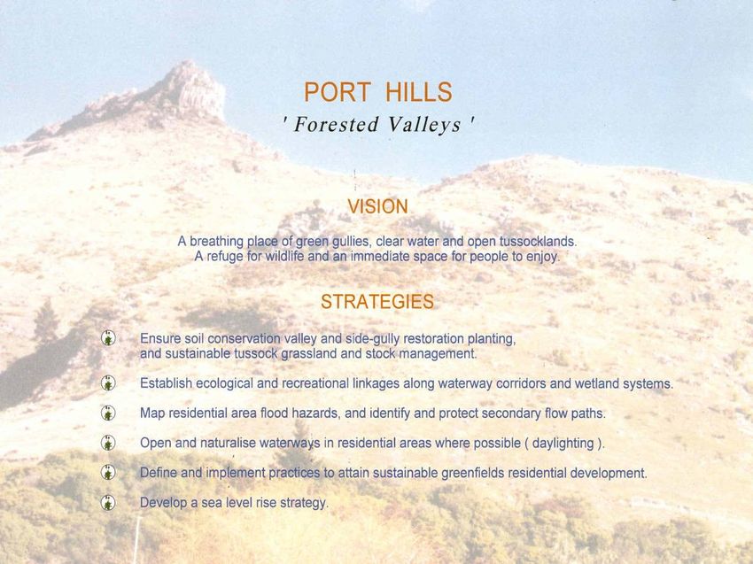
A fenced off timber-lined drain – no natural margins for this stream (CCC NPGU)24 To avoid such problems in the future it became the practice with any new subdivision to require existing waterways to be piped. These pipelines were designed to be part of a larger system that would be built if and when further urban expansion took place. Today the City’s land drainage infrastructure comprises many hundreds of kilometres of pipelines, concrete channels, utility waterways and degraded natural waterways. If past trends had continued, the built component would have steadily increased and the natural component would have disappeared. The management of infrastructural assets became an important issue worldwide in the 1980s. Some spectacular pipe failures occurred in the streets of London and their magnitude was being measured in how many Austin Minis would fit into the crater formed by the collapse. Asset management utilises computer-based records of the age, capacity, condition and strategic importance of individual system components. These data, along with other issues such as level of service, urban intensification and expansion, provided the basis for the determination of expenditure and revenue needs. The conventional utility asset management approach seemed well suited to the built component of the land drainage system. However, it was not compatible with the natural component as there were other values to consider. Also, a uniform level of service was inappropriate as natural waterways vary greatly in their character. What would the people of Christchurch expect from a well-managed system of waterways, wetlands and drainage? The response to this question was needed in order to satisfy the ‘level of service’ requirement of the Auditor General. Acceptable stormwater drainage standards were determined as part of a general level-of-service survey of utility assets. A workshop concerned with the natural component of the system, involving representatives from key stakeholders and other interest groups, produced a wonderful array of ideas. It was possible to group these ideas under each of the six values: ecology, landscape, recreation, heritage, culture and drainage. The next step was to divide Christchurch into project areas. This was done to acknowledge the diversity of surface water environments, local communities of interest and topography within the City, e.g. The Port Hills are different from the Avon River corridor or the Marshland market garden area. For each area a set of issues was identified and from these a set of objectives and an overall vision developed (see Appendix 2 for details). This then ensured that individual asset management initiatives were planned and designed in a way that supported the objectives and overall vision. Plans and illustrations were prepared to help stakeholders visualise the transformation that would occur within the different project areas. These images contributed to a favourable impression of the strategy as a whole.
25

Asset management project areas (CCC NPGU)

Port Hills vision and strategies (CCC NPGU)
26

Port Hills greening (CCC NPGU)

The Strategy lists over 300 projects totalling $160 million and scheduled over a 40-year period.

The Strategy was adopted by the council in 2000. It represents a commitment to wise resource
management as inspired by the RMA, the City Plan and key stakeholders. Councillors and
stakeholders all gave enthusiastic responses to the Strategy.

The Natural Asset Management Strategy can be simply described as an investment in the sustainable
management of the natural and physical resources that make up Christchurch’s system of waterways,
wetlands and drainage. Restoration and protection are the main capital expenditure items, but the
Strategy also requires the employment of people with appropriate skills. There is now an expert group
of staff and consultants with considerable experience who work collaboratively on surface-water
management projects. Organisational changes within Christchurch City Council have assisted in this
regard by combining surface water management with parks and recreation management.
27

The financial cost of the strategy can be compared with the past investment in drainage infrastructure.
The following diagram illustrates the cost to future generations in replacement and rehabilitation of
the existing piped system.

                                                             Projected cost of pipe renewals, Christchurch City

                               $45

                               $40

                               $35
  Cost per decade (Millions)

                               $30

                               $25                                                                                                     Future Piping

                               $20                                                                                                     Existing Piping

                               $15

                               $10

                               $5

                               $0
                                     1930

                                            1950

                                                   1970

                                                          1990

                                                                 2010

                                                                        2030

                                                                               2050

                                                                                      2070

                                                                                             2090

                                                                                                    2110

                                                                                                           2130

                                                                                                                  2150

                                                                                                                         2170

                                                                                  Decade                                        2190

Projected pipe replacement (CCC NPGU)

Pipes and other built items have a life determined by their condition or capacity limitations. Pipe
replacement often involves considerable disruption to roads and private property.

Within greenfields development the installation of concrete channels and large pipes often costs more
than either the creation of a naturalised waterway (including the cost of the land) or the restoration
and protection of an existing waterway.

A well-designed waterway has adequate space for a natural succession of plants from the water’s edge
to the drier upper bank. Gentle bank slopes and generous space for public access will often confer a
greater ability to attenuate peak storm flows.

A restored and protected surface water environment will not require replacement in the future and,
provided ample hydraulic capacity is provided in the design, no significant vegetation control will be
needed. The following diagram provides a simple representation of this for a waterway on public land.
Note the realisation of the six values.
28
Costs of piping Costs of ‘natural treatment’
Asset values
depreciate over time
Costs
Asset values
appreciate over time
Cost to replace $500 to $1300 per metre Cost to develop $30 to $1000 per metre
Replacement needed about every 150 years Replacement may never be needed
100 100
Percent Realised
Percent Realised
50 50
Landscape
Landscape
Recreation
Recreation
Drainage
Drainage
Heritage
Heritage
Ecology
Ecology
Culture
Culture
0 0
Waterway Values Waterway Values
Piping vs waterways (CCC NPGU)
The projected investments in protection and restoration are shown in the following diagram. It is
anticipated that this investment will eventually result in a waterways, wetlands and drainage system
that sustains natural and physical well-being – and which is less costly for future generations than the
default, utility system. The costs are in year 2000 dollars and are partly recoverable as development
contributions.
8
$m
6
4
2
0
1 5 9 13 17 21 25 29 33 37 Yrs
Hard (blue) vs Soft (maroon) infrastructure. The $4.1m horizontal line compares the new investment
with the alternative of a continuation of the past average annual expenditure on piping and
channelling (CCC NPGU)29 Avon River / Ōtākaro, through the suburbs – the six values at work The Avon River / Ōtākaro becomes slower and wider as it gets closer to the Avon–Heathcote Estuary, creating conditions amenable for small boats. River maintenance now allows water’s edge plants and aquatic plants to grow close to the banks in order to sustain spawning for whitebait, and shelter and habitat for fish and invertebrates. Avon River / Ōtākaro: ecologically sensitive waterway maintenance creates better ‘whitebaiting’ (left) but still allows clear passage for rowers (right) River habitats are the home of a distinct type of vegetation known as aquatic plants. These live beneath or on the surface of the water and comprise a mixture of filamentous algae and specialised flowering plants. Some of these aquatic plants grow so vigorously that they become a nuisance by clogging waterways and affecting water flows. This has led to the common use of the term ‘weed’ to describe these plants and a familiar sight in Christchurch waterways is the weed-cutter chopping these plants and dumping them on the banks awaiting transport away. But this designation is misleading and hides the true identity of these plants. Many of the submerged aquatics are actually native, and the major nuisance is created by one of only two common exotic species, curly leaf pondweed (Potamogeton crispus). This shallow-water aquatic dominates the margins out in the open and comprises the vast majority of the plant material removed. In deeper water, or under partial shade, less troublesome species or in some cases native species that appear similar can dominate, but at nothing like the biomass of the curly leaf pondweed. The situation could be much worse, however, if three aggressive exotic species that have invaded waterways elsewhere were present or uncontrolled.
30

Stream and street renewal in Papanui – a silo-busting initiative

A group of streets in one of Christchurch’s older suburbs were recently reconstructed with linkages
through to a naturalised utility waterway.

The streets incorporate landscaped water detention and treatment within space created by the
selective narrowing of carriageways, and property purchase

The waterway naturalisation was undertaken in conjunction with development of an adjoining
retirement village development. The boundary fence of the village was intentionally designed as a
‘see through’ fence to enable residents to enjoy views of the waterway. Collaboration between the
former City Streets Unit, the Parks and Waterways Unit and the developer of the retirement village
was initiated by a small group of Council staff determined to overcome organisational silos. It is the
kind of collaborative effort that many hoped would have occurred with local government reform.

Reconstructed streets with landscaped stormwater treatment trains (left) and a naturalised waterway
with ‘see through’ boundary fences (right)
31

Papanui Stream under construction: a transformation from a timber-sided utility drain
to a stream formed with meanders, pools, riffles and runs along with logs and rocks to
provide a diverse aquatic habitat. This was a collaborative, multidisciplinary project
(CCC NPGU)
32

Planning protocols and the South-West Area Plan – getting in at the start

The Natural Asset Management Strategy for Waterways and Wetlands was primarily intended to
achieve the sustainable management of Christchurch’s surface water environment for all its values. It
incorporated measures needed for floodplain management accompanying urban expansion and
intensification. It also included some water quality improvement measures, but these were not based
on any comprehensive city-wide assessment mainly because the water chapter of the natural resources
regional plan was still under preparation.

The Strategy provided a useful background for collaborative planning that was then beginning to
occur within the Council, especially on the Long Term Council Community Plan and area
development plans. The latter were formalised by an internal protocol for integrated area planning.
This protocol acknowledged the importance of an approach that examined a catchment-based area,
not just the area proposed for urban expansion or intensification.

The area-planning approach was developed from work carried out for a large urban growth area
located in south-west Christchurch. The study area chosen was defined mainly by the upper Heathcote
River catchment – an area larger than the likely development area. The scope that the larger area
provided turned out to have greater benefit than first thought.

The South-West Area Plan:
The preparation of this plan provided a further opportunity to promote a multiple-benefit approach to
surface water management. Happily, much enthusiasm has been expressed by staff and councillors for
the plan that emerged.

The natural hydrology of the catchment has four distinct areas:

(1) The northern part, where soils are pervious, groundwater levels well below the surface and there is
little natural runoff
(2) The middle part, where soils are poorly drained, springs and waterways exist and groundwater
levels are shallow and natural runoff occurs
(3) The southern part, where groundwater levels are high, and extensive natural ponding areas exist
(4) The valleys and spurs of the Port Hills

The surface water management scheme will implement all those measures identified for the upper
catchment in the Heathcote Floodplain Management Strategy. The post-development discharges into
the Heathcote River will approximate those of the original natural catchment.

Landscape, ecological, recreation, heritage and cultural studies were undertaken.

Naturalised and restored waterways and wetlands are intended to be in public ownership and will
form the skeleton of the green-space framework. They will also provide extensive recreational
corridors linking lowland areas with the Port Hills.
33

The foregoing investment in planning is essential for greenfields development. It identifies land that
needs to be excluded from development or acquired by strategic purchase. These costs can in due
course be recovered when a plan change takes place, as development contributions.

Joint CCC/ECan Planning and Consents Protocol for Surface Water Management:
This document provides for integrated catchment management plans to form the basis for area-wide
resource consent applications by the CCC as the land drainage system operator. See Appendix 3 for
the joint statement that outlines the purpose of the Protocol.
34

The Styx Vision – a great legacy in the making

The Styx River lies near the northern boundary of Christchurch City and, like the Avon and
Heathcote, is a small spring-fed coastal river. It has been affected by urban development to a minor
degree only and has the potential to be a natural asset for the City as significant as the Port Hills, the
coastline and Travis Wetland.

The Styx River catchment forms two of the 14 project areas covered by the Natural Asset
Management Strategy. It is worthy of special mention because it provides a rare opportunity to protect
and restore a river well before the catchment becomes urbanised.

The five visions for the Styx River5 and its catchment are:

•     To achieve a viable spring-fed ecosystem
•     To create a source-to-sea experience
•     To develop a living laboratory
•     To establish the Styx as ‘a place to be’
•     To foster partnerships as ‘we move forward together’

Styx Mill Reserve: a large green corridor separating Christchurch from Belfast township
(CCC NPGU)

More information about the Styx Mill Reserve is available from the Christchurch City Council
website6.

5
    http://www.thestyx.co.nz/new-zealand/visionone/
6
    http://www.ccc.govt.nz/cityleisure/parkswalkways/popularparks/styxmillconservationreserve.aspx
35
Typical rural scene – willows and grass Harakeke harvesting area
Jetty in Janet Stewart Reserve Manatu – doing well in the reserve
Pukeko, NZ scaup and mallard ducks, Wetland stormwater treatment and basin,
together with townhouses by a stormwater Redwood
pond connected to Styx Mill Basin Reserve
The Styx Vision Underway
These photographs contrast the existing Styx River (top left) with maturing indigenous vegetation
thriving within large riverside reserves. A predator-proof fence partly surrounds Styx Mill Basin.36
Waterways, Wetlands and Drainage Guide – a DIY reference for all
Design manuals are very influential documents. They determine how designers conceptualise, draw
and specify the work to be done. There is the expectation that strict adherence to the manual and
related standards will result in designs being more readily accepted by the approving authority. Over
time, designers develop efficient practices that tend to produce uniform solutions. At least that is what
traditionally has occurred in the design of streets and stormwater drainage.
Today, more imaginative and creative multi-benefit design approaches are expected for our public
spaces. The process may need to be guided by high-level strategies, policy objectives, public
engagement and the ability to purchase property.
The Waterways, Wetlands and Drainage Guide is in two volumes. The first, Part A: Vision, is
concerned with the physical context for the six values, natural asset management, realising visions
and involving the community. Part B: Design describes waterway and wetland flora and fauna,
habitat requirements, stormwater treatment and wetland restoration. Hydrologic, hydraulic and
inundation data are also included. The Guide was being reviewed in 2011.
More detailed information on the contents and how to order the Guide is available from the
Christchurch City Council website7.
7
http://www.ccc.govt.nz/cityleisure/parkswalkways/environmentecology/waterwayswetlandsdrainageguide/index.aspx37 Part Four: The people and reflections – a philosophical summary ‘You must be the change you wish to see in the world.’ Mahatma Gandhi The life force behind The Christchurch Waterways Story is the liberation of people so that they are able to protect and restore something they love. It is a consequence of the passion that has grown in this country for quality of life and quality of the environment. There is no doubt that the people who helped evolve and practise the new surface water management philosophy had the right mix of knowledge and experience. But what made it all happen was dedication borne of passion. So, given that New Zealanders are not ‘passion-less people’, what happened in Christchurch that caused some people to feel liberated enough to bring about change? The most significant events have been described in this story, but the first real movement came from certain key challenges of the Resource Management Act. Words like: ‘the sustainable management of natural and physical resources’ – ‘present and future generations’ – ‘restoration and protection’ and ‘kaitiakatanga’ inspire us to be spiritual as well as intellectual with our responses. The main outlet for this inspiration was the preparation of the City Plan. It involved many different contributors working collaboratively in multidisciplinary teams. The process had a unifying effect for the staff and councillors who joined the new Christchurch City Council from the amalgamating authorities. Many individuals and groups within the community also contributed to the City Plan. The events described in this story occurred in parallel with the preparation of the City Plan and each had a beneficial influence on the other. All the while there was a sequence of organisational changes that acknowledged the emerging surface water management philosophy. The culmination was the formation of a Waterways and Wetlands Team. This team included civil engineers, landscape architects and ecologists and was responsible for operation, maintenance, planning and budgeting. Design work for capital projects was undertaken by the Council’s in-house consultants who had similar skills to, and collaborated closely with, the Waterways and Wetlands Team. The Waterways and Wetlands Team no longer exists. It was dispersed when another round of restructuring combined parks and recreation with waterways and wetlands. This was done because the latter was seen as a ‘green’ activity and that efficiencies would result from the merger. The two main benefits have been in the areas of maintenance and land acquisition. The cost has been a decline in cohesion, sense of direction, dedication and passion. Fortunately there is now increasing interest in management philosophies that pursue an integrated response to environmental, social, cultural and economic matters. This is reflected in the Council’s most recent restructuring. Such a philosophy, applied with New Zealand determination and passion, must succeed.
You can also read


