Management Plan for Carbrook Ravine Nature Reserve - April 2016 - March 2021
←
→
Page content transcription
If your browser does not render page correctly, please read the page content below
Management Plan for
Carbrook Ravine Nature Reserve
    April 2016 – March 2021
Acknowledgements

Sheffield Wildlife Trust would like to thank the individuals and organisations who have
contributed to the formulation of this management plan. In particular, thanks go to Sheffield
City Council (Michael Senkans & John Gilpin), Natural England (Matthew Garthwaite) and
Steve Clements.

Report by:

               Nabil Abbas (Living Landscapes Manager)

               Hannah Lamare (Living Landscapes Assistant)

               Sheffield & Rotherham Wildlife Trust

               37 Stafford Road

               Sheffield S2 2SF

               0114 263 4335

               www.wildsheffield.com
Contents
1 INTRODUCTION............................................................................................................ 4
1.1 Purposes and formulation of the plan .......................................................................... 4
2 MANAGEMENT AIMS & OBJECTIVES .......................................................................... 5
3 SITE DETAILS ............................................................................................................... 8
3.1 Location and site boundary (Figure 1) .......................................................................... 8
3.2 Landscape value and context....................................................................................... 8
3.3 Site tenure and occupancy ........................................................................................... 9
3.4 Designations and Policy Context .................................................................................. 9
3.5 Adjacent land ownership .............................................................................................. 9
3.6 Site history and past management ............................................................................. 10
3.7 Services (Figure 6) ..................................................................................................... 11
3.8 Infrastructure (Figure 5) ............................................................................................. 11
   3.8.1 Public Rights of Way and Informal Paths (Figure 2) ........................................... 11
   3.8.2 Boundaries ......................................................................................................... 11
   3.8.3 Interpretation Features and Other Structures ..................................................... 12
3.9 Archaeological Interest and Existing Features (Figure 7) ........................................... 12
3.10 Current funding schemes and grants ....................................................................... 12
3.11 Pipworth Rec SUDS scheme ................................................................................... 12
4 ENVIRONMENTAL INFORMATION ............................................................................. 13
4.1 Topography................................................................................................................ 13
4.2 Geology and Pedology ............................................................................................... 13
4.3 Climate ...................................................................................................................... 13
4.4 Hydrology (Figure 3) .................................................................................................. 13
4.5 Biodiversity and Biodiversity Action Plan overview ..................................................... 13
 UK BAP Priorities (Short and Medium List only) .............................................................. 14
4.6 Biodiversity List of surveys, monitoring schemes and reports .................................... 15
5 BIODIVERSITY ............................................................................................................ 17
 5.1 Overview………………………………………………………………………………………17
 5.2 Woodland……………………………………………………………………………………..17
   5.2.1 Wet Woodland ................................................................................................... 17
   5.2.2 Semi natural deciduous woodland ...................................................................... 18
   5.2.3 Fungi .................................................................................................................. 18

                                                                     1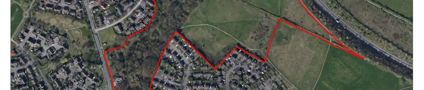
5.3 Scrub……………………………………………….. ........................................................ 19
    5.4 Grasslands................................................................................................................. 19
       5.4.1 Neutral grassland ............................................................................................... 19
       5.4.2 Amenity grassland.............................................................................................. 20
       5.4.3 Acid grassland/heathland mosaic ....................................................................... 20
    5.5 Hedgerows................................................................................................................. 20
    5.6 Zoological interest ..................................................................................................... 21
       5.6.1 Invertebrates ...................................................................................................... 21
       5.6.2. Fish, amphibians & reptiles................................................................................. 22
       5.6.3 Birds ................................................................................................................... 22
       5.6.4 Mammals ............................................................................................................ 23
       5.6.5 Bats .................................................................................................................... 23
6 INFRASTRUCTURE ....................................................................................................... 24
    6.1 General ...................................................................................................................... 24
    6.2 Footpaths and bridleways (Figure 2) .......................................................................... 24
    6.3 Boundaries ................................................................................................................ 24
    6.4 Signage and seating.................................................................................................. 25
7 CULTURAL CONTEXT ................................................................................................... 26
    7.1 Recreational usage .................................................................................................... 26
    7.2 Information and interpretation .................................................................................... 26
    7.3 Community ................................................................................................................ 26
    7.4 Education .................................................................................................................. 27
8 ECONOMIC CONTEXT……………………………………………………………………….....28
    8.1 Productive land use ................................................................................................... 28
    8.2 Grants and Funding................................................................................................... 28
    8.3 Employment and Training.......................................................................................... 28
9      ORGANISATIONAL INFORMATION ............................................................................ 29
 9.1 Site safety, security and maintenance ......................................................................... 29
 9.2 Management structure………………………………………………………………….…….29
10 WORK PROGRAMME ................................................................................................. 30

                                                                          2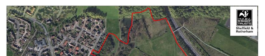
FIGURES

Figure 1: Site location and boundary

Figure 2: Public Rights of Way and desire lines

Figure 3: Hydrology

Figure 4: Phase One habitat survey 2010

Figure 5: Infrastructure

Figure 6: Services

Figure 7: Archaeological features

Figure 8: Management compartments

Figure 9: Aerial photo 2011

Figure 10: Woodland retention map

Figure 11: HLS agreement map

                                          3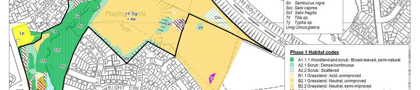
1 INTRODUCTION

Sheffield & Rotherham Wildlife Trust (SRWT) is part of a national association of 47 local Wildlife
Trusts, which work with communities throughout the UK to protect wildlife in town and country.
Sheffield & Rotherham Wildlife Trust aims to promote conservation, advance education in
environmental matters and improve the quality of life in Sheffield and Rotherham, through the
development and promotion of sustainable land management practises, linked directly to both rural
and urban regeneration.
The Nature Reserves Programme aims to establish a suite of high quality, well managed and
accessible wildlife reserves, which will reverse the past unsustainable trends in land use on some of
Sheffield’s finest wildlife sites. The work will also assist in the environmental regeneration of Sheffield
by linking the management of land for wildlife, with the creation of jobs and green enterprise initiatives
across the city. Ranging in scope from small urban commons, to large moorland areas, these sites
act as the core to Sheffield Local Biodiversity Action Plan, and will be managed in partnership with
Sheffield City Council, statutory bodies, voluntary organisations and members of the public, for the
benefit of people, wildlife and the wider environment of Sheffield.

1.1      Purposes and formulation of the plan
This management plan has been formulated for the following reasons:
•      To provide comprehensive and cohesive information about the nature reserve in one
document, with reference to other documents where necessary.
•      To outline the key long-term aims and the associated objectives that form the framework of
management.
•        To outline the rationale for management so as to give a clear and comprehensive
explanation of why aspects need management and in what form that management will take place.
•       To provide a key document from which projects are developed and associated funding
sought.
•         The plan allows consistency and continuity so that if or when changes of staff take place, or
changes in ownership or disposal of the land occurs, then management aims, objectives and
prescriptions are continued.
The work programme is set out within this document. However, the nature of work programmes is
such that they vary and are modified due to unanticipated changes or developments. Therefore the
full annual work programmes are kept and updated electronically at the SRWT offices.
The first SRWT management plan covered the period from 2002-2006, followed by a second plan in
2006-2011. Due to capacity issues, a reviewed plan for the next 5 years was not written. Therefore
the plan was extended to cover the period from 2006 to 2015. The current plan sets out a detailed
work programme for the period of 2016 – 2021, and aims to continue with a programme of
management for the continued benefit of wildlife and local people who use the site.

1.2 Vision Statement
Carbrook Ravine is a valuable area for its biodiversity, history and amenity usage, being one of the
few areas of semi-natural habitat in the locality, and a remnant of the Sheffield Deer Park. Its location
in one of the most socially and economically deprived parts of Sheffield increases its importance as
an oasis of green space and offers both opportunities and challenges for local engagement.

                                                  4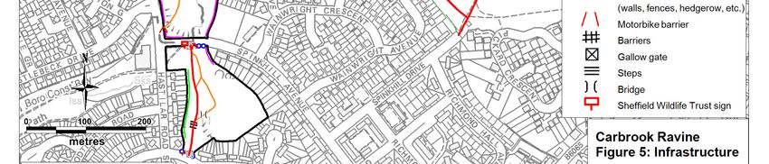
2 MANAGEMENT AIMS & OBJECTIVES

                                     Aims                                                          Objectives

  2.1 BIODIVERSITY

                                                               1.1 Continue traditional hay meadow management on the three haymeadows
                                                                   (Compartments 3, 4 & 5)
       Aim 1           Maintain the grassland areas of the
                        reserve in favourable condition        1.2 Maintain two open grassland areas in Compartment 1 for amenity use
                                                               1.3 Remove litter & fly-tipped material from grasslands
                                                               1.4 Restore and maintain hedgerow on southern boundary of Compartment 4

                                                               2.1 Maintain areas of scrub in Comps 3, 4,5 in line with HLS prescription to
                                                               maintain a mosaic of scrub and wildflower-rich grassland with:
                                                                   •   20-40% scrub cover, with diverse age & height structure
                                                                   •   No more than 50% of scrub mature/over-mature
       Aim 2         Maintain successional areas of scrub in
                              favourable condition                 •   Tree species at irregular spacing, canopy comprising 10-30% of area
                                                                   •   Undesirable weed species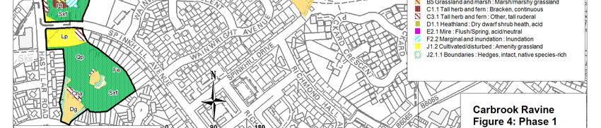
4.1 Reverse the encroachment on scrub on wet heathland area in south of Comp 2
                     Maintain and wet heathland and wetland
                          areas in favourable condition       4.2 Reduce shading of wetland habitat along the course of Car Brook in Comp 1
      Aim 4
                                                              and southern end of Comp 2

                                                              5.1 Maintain an up-to-date record of biological information from surveying and by
                                                              encouraging the reporting of observations from SRWT staff, members of the public
                                                              and local groups.
      Aim 5             Monitor and record the ecological     5.2 Monitor condition and composition of hay meadows
                             features on the reserve
                                                              5.3 Monitor use of site by HLS target bird species
                                                              5.4 Undertake Phase 1 habitat survey to inform next management plan
                                                              5.5 Undertake breeding bird survey during management plan period if resources
                                                              allow

2.2 INFRASTRUCTURE

                                                              6.1 Improve and maintain paths through regular removal of encroaching vegetation
                       Maintain and improve access to the     to improve sight-lines and increase feeling of safety for users
      Aim 6
                                     reserve                  6.2 Monitor infrastructure and maintain bridges and steps in good state of repair
                                                              6.3 Undertake in-house tree surveys every 2 years, and full QTRA survey every 6
                                                              years

                     Discourage negative and damaging use     7.1 Prevent unauthorised access onto the reserve by motor vehicles
      Aim 7
                                  of the site                 7.2 Deter fly-tipping on reserve and other anti-social behaviour around entrances

                                        6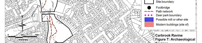
2.3 CULTURAL

                    Promote and encourage local
   Aim 8       participation in the management of the   8.1 Promote and encourage positive use of the site
                                reserve

2.4 ECONOMIC

                                                        9.1 Obtain additional financial grant aid for the management of Carbrook, as
               Develop ongoing sources of grant aid     opportunities arise
   Aim 9         and other income to support the
                   management of the reserve            9.2 Raise the profile of the reserve and generate positive publicity wherever
                                                        possible

                                 7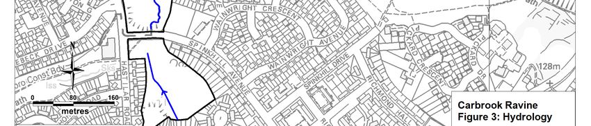
3 SITE DETAILS

3.1 Location and site boundary (Figure 1)
Carbrook Ravine comprises a strip of land running along either side of the Car Brook, at the eastern
edge of the Manor Estate, in south-east Sheffield. It has a total area of 13.4 hectares, centred on grid
reference SK 395 860. The site is divided into two parts by Spinkhill Avenue, 11.7 ha to the north and
1.7 ha to the south.
For management purposes the site has been divided into the following compartments (see Figure 8):
Compartment 1 is Spring Wood at the south of the reserve. It contains a mixture of wet woodland
around the Car Brook, semi-natural deciduous woodland and small areas of amenity grassland.
Compartment 2 is Carbrook, containing the Car Brook. It runs from Spinkhill Avenue to the north
boundary of the reserve. It consists mainly of wet woodland and semi-natural deciduous woodland.
There is a small amount of damp acid grassland/heathland mosaic.
Compartment 3 is Scrubby Meadow at the north of the reserve. It comprises dampish neutral grassland
with areas of scrub around the margins.
Compartment 4 is Hay Meadow which consists of neutral grassland and some scrub.
Compartment 5 is Restoration Meadow, consisting of grassland which was re-seeded with a native
seed mix in 2015. It also contains some scrub.
See Figure 4 for full Phase 1 habitat information.

3.2 Landscape value and context
Carbrook Ravine lies at the eastern end of the Manor Estate, to the north of Woodthorpe and west of
Handsworth, in urban east Sheffield. It has a total area of 13.4 hectares, including significant areas of
woodland and grassland, some heath and wetland. Together with Pipworth Recreation Ground and
Bowden Housteads Wood, the reserve forms an area of green belt land, extending through the
surrounding housing and creating an important green link to the countryside beyond. The site has a
long history of human usage, and its proximity to a large housing estate makes it valuable for amenity
and recreation.
The site is an important open space, much used by people for informal leisure and recreation. The
wooded character of the ravine adds significantly to the environmental quality of this part of the Manor
housing estate, adding variety and visual interest to a predominantly man-made urban location. The
woodland and scrub helps to screen Mosborough Parkway to the east of the reserve from the houses to
the west – reducing visual intrusion and acting as a buffer against both noise and air pollution.
Despite the encroachment of housing and new roads during the 20th century, the ravine is one of the
few remaining elements of the rural Sheffield landscape that existed before the current housing estates
were built in the 1930s, and as such is a very significant feature in the present day landscape of eastern
Sheffield.
As the Car Brook acted as the boundary to the Sheffield Deer Park in years past, it now provides a
visual and atmospheric divide, marking the boundary between the modern housing estates of Manor
and Woodthorpe. With housing located on the high ground to either side of the Carbrook Ravine, and
immediately surrounding Spring Wood, the reserve can be seen from a large number of properties, and
as a result contributes greatly to the views experienced by those householders. Newer housing
developments at the former site of Stradbroke College also overlook the reserve, increasing the
significance of its role in the landscape still further.
Despite its obvious value and importance, the appearance and character of the reserve suffer as a
result of regular fly-tipping, including domestic and garden waste. During the time of the 2002-2006
management plan, various vehicle barriers and A-frame pedestrian gateways were installed to reduce
incidences of fly-tipping, and regular clearance days have been undertaken since SRWT took on
management of the reserve.
3.3 Site tenure and occupancy
Carbrook Ravine is owned by Sheffield City Council. Over the twenty five years prior to 2002, several
management plans were developed for the site. None of these plans have ever been fully implemented,
because insufficient resources have been available. From April 2002, the site was leased to SRWT for
a period of 30 years.

3.4 Designations and Policy Context
The majority of the Carbrook Ravine reserve was identified as a Site of Scientific Interest in the
Sheffield Nature Conservation Strategy (1990), indicating it to be of city-wide importance for nature
conservation. As a result of this, it was designated in the Sheffield Unitary Development Plan (1998)
as an Area of Natural History Interest, and given protection from development by Policy GE 13, which
states that:
       “Development which would damage Areas of Natural History Interest will normally not
       be permitted.”

It has been declared as part of a statutory Local Nature Reserve covering Spring Wood, Carbrook
Ravine & Bowden Housteads Wood. With this designation it will receive additional protection, under
UDP Policy GE12:
       “Development which would damage Sites of Special Scientific Interest or Local Nature
       Reserves will not be permitted.”

The southern section of the reserve (Spring Wood) is also designated as Open Space in the Unitary
Development Plan (UDP), to which Policy LR4 applies:
       “Open space will be protected from built development where it is needed for outdoor
       recreation, or where it makes a valuable contribution to the natural environment, urban
       heritage or quality of life. As opportunities arise, open space will be: (a) improved,
       where it is of poor quality; and (b) created, where there is a shortage.”

The northern part of the reserve (from Spinkhill Avenue to the south western boundary of Bowden
Housteads Wood) falls within Sheffield’s Green Belt, which is covered by several UDP policies, of which
Policy GE2 is the most significant for the nature reserve:
       “In the Green Belt, measures will be taken to: (a) maintain and enhance those areas
       with a generally high landscape value; and (b) improve poor landscapes in priority
       areas.”

The whole reserve forms part of a wider network of designated Green Links running towards Fairleigh in
the south, Darnall in the north, Wybourn in the west and Woodhouse in the east. Sheffield’s network of
Green Corridors and Green Links is designated under the UDP, to protect and enhance its function in
enabling the movement of people and wildlife through a pleasant green environment. Policy GE10,
which deals with the Green Network, states (amongst other things) that:
“A Network of Green Corridors and Green Links will be: (a) protected from development which would
detract from their mainly green and open character or which would cause serious ecological damage;
and (b) enhanced by encouraging development which increases their value for wildlife and recreation.”
Several of the habitats and species found on the reserve are listed either as key habitats and priority
species in the UK Biodiversity Action Plan, or as priority habitats and species in the Sheffield Local
Biodiversity Action Plan. This places particular emphasis on conservation action intended to contribute
to the sustainable management of these habitats and species.

3.5 Adjacent land ownership
Spring Wood is largely surrounded by housing and domestic gardens. It also has Spinkhill Avenue to
the north, Fishponds Road to the south and Hastillar Road South, to the west.
The main part of Carbrook Ravine is bounded by housing, roads (Castlebeck Avenue, Spinkhill Avenue
and the A57 Mosborough Parkway), playing fields and public open space. Bowden Housteads wood lies

                                                 9
immediately to the north of the site. Pipworth Recreation Ground lies immediately to the north west of
the site. Recent housing has been constructed on the former site of Stradbroke College to the east.
3.6 Site history and past management
During the medieval period, the Car Brook appears to have formed the south-eastern boundary of
Sheffield Deer Park, the site of which is now covered by the housing developments of Park Hill, Norfolk
Park, the Manor estate and Arbourthorne. The Park was originally a very extensive deer park dating to
before 1281, covering some 2,500 acres at its greatest extent, and was associated with the Lords of
Sheffield. 1000 fallow deer (Dama dama) were present in the park in 1637 (Jones, M., 1993). The Car
Brook also formed the Parliamentary and Municipal boundary, as well as the township boundary
between Handsworth and Sheffield.
The Carbrook Ravine nature reserve falls into two distinct areas; Spring Wood, to the south and the
Carbrook Ravine itself, to the north. The names given to each give some clue to their past
management. Spring is an Old English word for a coppice wood, suggesting that there has been
coppice management at some point in the wood's history. This is supported by the presence of old
coppice stools in Spring Wood. The word Car is derived from Carr, which is an Old Norse woodland
name that describes low lying woods bordering streams and rivers in which alders (Alnus glutinosa) and
willows (Salix sp.) predominate (Jones, 1993). This is currently the predominant woodland type along
much of Carbrook Ravine, and is likely to have been little changed since the brook was first named.
The available cartographic evidence suggests that both parts of the reserve were part of a ‘Spring
Wood’, which ran along the valley of the Car brook. It was physically separate from the medieval
Bowden Housteads wood and it is believed that the north edge of the reserve represents the southern
boundary of that wood. The modern Spring Wood to the south of Spinkhill Avenue still retains the
outline of what may have been an internal compartment of this larger Spring Wood, as recorded by Ed
Dennison Archaeological Services in 2000.
The southern two thirds of the area have been shown as woodland, with the northern part as open
ground, at least since a survey carried out in 1835. The survey area has remained much the same until
the present day.
O.S. maps show that the surrounding area was entirely rural until the 1930s, when a large housing
estate was built to the south-west. The construction of Spinkhill Avenue, as part of the Manor housing
estate in the 1930s, divided Spring Wood from the northern section of Carbrook Ravine. More recently,
increased housing capacity, with its associated hard surfacing and drainage works, has resulted in
flooding and pollution problems in the brook. To combat this, a storm water storage lagoon has been
constructed at the northern end of the reserve.
There had been limited management work within the reserve in the last twenty years prior to 2002, apart
from the mowing of the amenity grass areas along the edge of the reserve at Spinkhill and Castlebeck
Avenues and occasional tree safety works. The main path through Carbrook Ravine was surfaced
during the 1980s.
Bowden Housteads Wood, which lies directly to the north of Carbrook Ravine, is a descendent of an
ancient sessile oak (Quercus petraea) wood. It was used as wood pasture in the fourteenth century.
By the end of the sixteenth century, Bowden Housteads had become a coppice wood, until, by the
middle of the nineteenth century, coppicing had declined, after which the wood was systematically
planted and managed to a canopy wood or high forest. From this time, some plantation forestry was
also practised, with coniferous species being planted as ‘nurse’ trees for the slower growing deciduous
species. For example, oak (Quercus sp.), ash (Fraxinus excelsior), birch (Betula sp.), sycamore (Acer
pseudoplatanus), sweet chestnut (Castanea sativa) and lime (Tilia sp.) were planted with larch (Larix
decidua) as a nurse in the late nineteenth century. In the last thirty years, Bowden Housteads Wood
has been divided into three parts by the construction of the Sheffield Parkway, in 1970 and the
Mosborough Parkway, in 1990. Since the late 1980s, the wood has been managed to improve its value
for wildlife, employing such techniques as irregular thinning and the creation of glades. None of this
conservation management has taken place within the area of the Carbrook Ravine Nature Reserve.
In 2014 part of the former Stradbroke College site, immediately to the south-east of Compartment 5,
underwent a change in management. Having previously been managed as grassland by SRWT, the
land was put into Sheffield City Council’s EWGS woodland creation scheme. The area was planted with
native broadleaved tree whips as part of the city-wide Urban Nature Parks initiative.
103.7 Services (Figure 6)
Several Yorkshire Water combined and surface water sewers cross the site. One electricity cable
enters the reserve by Danewood Avenue, but only extends a short distance. There are no gas pipes
within the reserve and General Cable does not have any equipment there. There are no BT cables
within the site. The services for the extension to the reserve have not been investigated.
A storm water storage facility (which is intended to buffer surface drainage entering the Brook from
nearby housing and prevent flash-flooding downstream) has been constructed at the northern end of the
site (by Pipworth Recreation Ground), immediately downstream of the reserve boundary.
If excavation works or similar ground-disturbing works are to take place, the original utilities maps must
be referred to as well as on-the-ground checks.
3.8 Infrastructure (Figure 5)
3.8.1 Public Rights of Way and Informal Paths (Figure 2)
The extensive path network includes Public Rights of Way and numerous desire lines (some of which
are surfaced). In previous management plans, substantial improvements to the paths took place and
they are generally accessible throughout the year. Vegetation is managed to ensure open ‘rides’ along
paths which benefit users who enjoy better views and also create an improved habitat for bats.
The Sustrans National Cycle Route runs along the north of the main part of the site. Sheffield Wildlife
Trust does not take responsibility for the route.
3.8.2 Boundaries
The majority of the reserve boundary is marked by a number of short individual boundaries (most of
which are fences, some associated with a privet or similar hedge), each associated with a separate
garden plot neighbouring the reserve. Some of these boundaries are in better condition than others,
and some are in a dilapidated state. The properties to the west of Spring Wood have almost all had new
metal fencing erected along the reserve boundary.
The boundary to the northeast is marked by a hedge that runs along the top of a grass bank running
parallel to, and above, the Mosborough Parkway. This is in good condition, as it is continuous with no
gaps and serves to screen people walking on the path from the road. Bowden Housteads Wood and
Pipworth Recreation ground are immediately adjacent to the reserve’s northern boundary, although
there are no physical structures marking this boundary. A tarmac path marks the boundary to the east of
the reserve, adjacent to the former Stradbroke College recreation fields, this is maintained by Sheffield
City Council.
A hawthorn hedge marks the boundary to the east of the reserve, between the reserve and the former
Stradbroke College recreation fields. The easternmost part of this hedge was laid in 2015, but the
remainder is mature/over-mature and some of the older hedge trees are declining. The unmanaged
section of the hedgerow would benefit from restoration. Post and rail fences have been erected at the
south end of the reserve, at the top of Spring Wood, and along part of the western boundary, adjacent
to Castlebeck Avenue.
The pavements running alongside Castlebeck Avenue and Spinkhill Avenue form the boundaries to the
west and south. These are made more secure by the wooden barriers, and the presence of large
boulders. A significant slope from Spinkhill Avenue into the reserve also restricts access by vehicles.
The main entrance of the site at Castlebeck Avenue has benefited from the addition of an interpretive
gate, though a boulder obscures it partially as the gate was often vandalised and opened, allowing
access for unauthorised vehicles. This management plan suggests the re-situation of the boulder in
front of the gate to the right of the gate to prevent vehicles from accessing through a small gap and the
welding back into place of the gate. Developers of the former Stradbroke College site have also
installed A-frames and other anti-motorbike access points at the reserve’s boundaries.
113.8.3 Interpretation Features and Other Structures
There are two new wooden SRWT noticeboard-type signs at entrances to the reserve on Danewood
Avenue and Castlebeck Avenue. A third sign at Spinkhill Avenue entrance was removed following
repeated vandalism.
A stainless steel interpretive panel and decorative fencing are installed at Fishponds Rd entrance, and
there is a sculptural gate the main entrance off Castlebeck Avenue. Two metal benches were installed
in 2015 at the edge of the meadows in Comps 3 and 4.
3.9 Archaeological Interest and Existing Features (Figure 7)
The majority of the reserve is shown as woodland on the 1855 Ordnance Survey map of the area.
There are no records of any significant archaeological features within Carbrook Ravine. Apart from the
medieval deer park boundary, which roughly follows the Car Brook (on the west side), there may have
been a flood mill in the north of the site, dating back to the eighteenth century, to the east of the brook.
These are detailed in a preliminary walk-over survey by Ed Dennison in 2001. Alternatively, this site
may represent former iron or coal workings. There is a bridge across the Car Brook in the north of the
site, which was shown as being stepping stones on the OS 1855 6 inch map, but had become a
footbridge by the OS 1890 25 inch map. There was formerly a terrace of houses in the north west of the
site fronting onto the junction of Danewood Avenue and Castlebeck Avenue, which was shown on the
OS 1924 six inch map and formed part of the Manor Estate, which was subsequently demolished.
3.10 Current funding schemes and grants
Current funding schemes are in place from Higher Level Stewardship (HLS), England Woodland Grants
Scheme (EWGS), Viridor Credits Environmental Company and Awards for All.
The HLS agreement runs from 2013 to 2023 and details the following management of the reserve: the
maintenance of successional areas and scrub; restoration of species-rich, semi-natural grassland and
the restoration and maintenance of grassland for target features.
The EWGS runs from 2012 to 2017 and details the following management should take place to meet
funding specifications: a Woodland Welcome sign shall be erected and maintained at access off
Castlebeck Avenue; main footpaths will be strimmed to a distance of 1m on either side of the path;
gates, bridges, benches and welcome boards will be maintained to ensure that all are clean and safe to
use; litter will be collected and removed from all areas in an appropriate manner and collections will be
carried out on a regular (at least once a month) basis; clearance of fly tipping shall be carried out as
soon as possible following identification of such acts; repair and rectification to signage, way-markers
and other infrastructure will be carried out as soon as possible following notification.
The Viridor “Carbrook Meadow Restoration” project runs from 2014 to 2016 and covers the restoration
of the hay meadow in Compartment 5, with hay cutting, ground preparation, reseeding and weed
control.
The HLF Awards for All “Stradbroke Community Meadow” project runs from 2015 to 2016 and includes
the installation of two benches, laying 85m of hedgerow, scrub removal, tools & PPE and hay cutting.
3.11 Pipworth Rec SUDS scheme
In 2016/17 Sheffield City Council are proposing to install a Sustainable Urban Drainage Scheme
(SUDS) in Pipworth Recreation Ground, which borders the reserve to the north-west. The proposed
scheme will be downstream of the nature reserve and will not therefore have a direct impact on the site.
However SCC officers have committed to work closely with SRWT to improve security along the
boundaries of the site as part of the scheme. These works will address illicit motorbike access, which is
a regular problem on the reserve and the adjoining open spaces. In particular the gates and barriers at
the end of Danewood Avenue need to be improved.
124 ENVIRONMENTAL INFORMATION
4.1 Topography
Carbrook Ravine is a small but fairly steep-sided valley, sloping from 130 metres above ordnance
datum at the highest point (immediately above the former Stradbroke College housing development), to
95 metres above ordnance datum at the lowest point (at the point where the Car Brook crosses the
northern reserve boundary).
4.2 Geology and Pedology
The underlying geology of the wider area consists of the Westphalian B Series (Middle Coal Measures),
part of the Silesian (Upper Carboniferous) period. This series comprises successive layers of
sandstone, coal seams and intermediate rocks such as shale, siltstones and mudstones. The strata
through the area dips towards the northeast at an angle of between 5 and 10 degrees. The geology is
overlain by brown earth and acid brown earth soils.
4.3 Climate
Data is available for the thirty-year average (1981 - 2010) from the following local weather station.
Table 1. Local climate data
Location Mean Annual Mean Annual Average Temperature (0C)
Rainfall (mm) Sunshine (hrs)
Max Min
Sheffield 834.6 1444.9 13.4 6.6
(131m)
4.4 Hydrology (Figure 3)
The main watercourse through the site is the Car Brook, which flows in a northerly direction. The
inundation of ground adjacent to the stream, resulting in significant areas of wet woodland, is a
significant feature of the site.
Evidence of oil pollution in the stream has been noted in the recent past, possibly from the surrounding
highways. The Environment Agency had advised that the water quality of the Car Brook was being
adversely affected by several combined sewer outflows. The storm water storage facility on the Car
Brook at the northern end of the reserve is intended to help address this.
The current state of the water quality seems good on appearance.
4.5 Biodiversity and Biodiversity Action Plan overview
The wooded areas of Carbrook Ravine (the main habitat) are dense, often impenetrable, mixed
deciduous woodland, and consist of three different NVC communities– oak dominated (W10), crack
willow dominated (W6b) and ash dominated (W8). There is a wide range of species found in the
canopy throughout all the woodland types, including oak, ash, sycamore, lime, birch and beech (Fagus
sylvatica). Hawthorn (Crataegus monogyna), hazel (Corylus avellana), oak, blackthorn (Prunus spinosa)
and birch are found in the shrub layer. The woodland links into a mosaic of other habitats, including
large areas of semi-improved neutral grassland, dry acid grassland, amenity grassland (near to the
reserve edges), tall ruderal vegetation (mostly in the wet soil at the stream edge), heather dominated
patches, areas of dense bramble and bracken (Pteridium aquilinum), scrub and hedgerows, each of
13which individually supports its own community of plants, animals and fungi, and which together
represent a very valuable natural heritage resource. Further detailed information is available in Section
5 – Biodiversity.
Several of the habitats and species found in the reserve are of national or local significance, being listed
as conservation priorities in either the UK Biodiversity Action Plan or the Sheffield Local Biodiversity
Action Plan.
Table 2. Biodiversity Action Plan (BAP) Priority habitats and species at Carbrook
Ravine Nature Reserve
UK BAP Priorities (Short and Medium List only)
Habitats Wet woodland
Lowland heath
Lowland dry acid grassland
Neutral grassland
Deciduous woodland
Hedgerows
Species bluebell (Hyacinthoides non-scripta)
skylark (Alaudia arvensis)
song thrush (Turdus philomelos)
bullfinch (Pyrrhula pyrrhula)
hedgehog (Erinaceous europaeus)
Sheffield BAP priorities
Grassland
Habitats
Woodland
Heathland
Wetland
Table 3. Species listed on Schedules 1, 5 & 8 of the Wildlife & Countryside Act 1981 (as
amended), which are present at Carbrook Ravine Nature Reserve.
Carbrook Ravine
Mammals Pipistrelle bat.
Flora Bluebells
Of the 85 invertebrate species recorded at Carbrook Ravine in Sorby records, 18 are Local or
Notable/Nb. A third of the hoverfly species recorded are rare, or have restricted distributions. Four of
the species of Hymenoptera (ants, bees and wasps) recorded are of Local status.
144.6 Biodiversity List of surveys, monitoring schemes and
reports
Summary of surveys at Carbrook Ravine & Spring
Author Date Survey
Wood
Inner City Habitat Survey Phase II. An ecological
assessment of the site. The majority of the site is willow
Ecological Survey carr; the small acidic bog has contracted through drying
out in recent years. Extension of the site northwards is
Roger Shaw 1992 proposed to enhance its biodiversity value.
A detailed phase 2 survey into the ecological value of the
site. The wetland areas in the south are particularly
Author important, especially as wetlands are rare in the Manor
unknown 1998 Ecological Survey Castle area.
Summary of Various maps and species lists of site and surrounding
Matty Levan 2001 existing records areas from 1996.
An ecological survey of Bowden Housteads Wood and
Page 2000 Ecological survey Carbrook Ravine.
Examination of the site was based on a request for
information about the present ecological interest of the
site with suggestions as to how areas of high ecological
value should be improved or protected. A site map was
formulated to distinguish the various existing habitat
Sheffield City unkn types. Only 1 section ('Area G') was in need of protection,
Museums own Ecological Survey as the most vulnerable habitat on the site.
The aim was to find out who uses the reserve, for what
purpose, where they come from and how they would like
to see the reserve managed for use with the management
plan. Most visitors use Carbrook Ravine for short walks
Henna Visitor Survey either around or as a short cut through the reserve. The
Tanskanen 2001 Report main threats are danger of motorcyclists and litter.
The survey was required to gather sufficient information
to identify the extent, nature, character, condition and
quality and probable date of any archaeological and
historic features within the survey area. Only 4
Ed Dennison archaeological sites were recorded within the survey
Archaeological Archaeological area, with a further 8 sites lying within a 500m wide buffer
Services 2001 Desk-Top Survey zone.
Detailed description of habitats in compartments, habitats
map and species list. The mosaic of habitats present
include, wet willow carr woodland, broad leaved semi
natural woodland, scrub, bracken, un-improved neutral
grassland, small areas of acid grassland and areas of tall
Belinda Wiggs ruderal herbs. The site is important for its location,
& Susan Phase 1 Habitat providing a large area of species rich green space in a
Shorter 2001 Survey densely residential area.
Jim Flanagan 2001 Invertebrate survey A list of 20 species found on 3rd October.
Desk top
Sorby Natural A summary and assessment of all Sorby invertebrate
2001 invertebrate survey
History records. There are 85 species, including 18 that are LocalSociety or Notable/Nb. The wide diversity if habitats on site
encourage a high number of different species.
Small Mammal Methodology & map. Bank voles, common shrews and
Matt Shaw 2001 survey wood mice caught in Longworth traps.
Maps and species lists. 24 species present during 10
visits during the spring, 11 species holding territories.
Susan Shorter Songthrush, bullfinch and skylark were seen, these are
& Thomas on the RSPB red list in the "Birds of Conservation
Simcock 2001 Bird survey Concern."
About 20 species of fungi found. The site has potential as
Michael a good site for fungi as there is a lot of dead wood
Senkans 2001 Fungi survey adjacent to the stream. Future surveys recommended.
Bat survey using bat detectors carried out over 3 nights in
August and September. 2 types of pipestrelle bat were
seen. The most frequently used flight paths correlated
Liz Giles 2003 Bat Survey with the woodland along the stream.
Some burrows were found, but with a lack of any other
evidence it was difficult to say whether these were water
voles or brown rat burrows. The lack of other evidence
suggests that there may not be any water voles. This may
Liz Giles & be due to the lack of grasses on the bank side, as water
Ceiri Osman 2004 Water Vole survey voles require grasses on the bank for food and cover.
Anderson Tree Recommendations for removal of trees and limbs
Care 2004 Tree safety survey outlined.
Small mammal
Ruth Snelson 2007 survey Of reserve ‘extension’ only
Steven
Sylvester 2007 Phase 1 survey Of reserve ‘extension’ only
Alistair Phase 1 Survey Detailed description of habitats in compartments, habitats
Campbell 2010 throughout site map and species list.
To gather information on the people that use Carbrook
Ravine and why they visit the area as well as their
opinions on how they think the site can be improved or
Matthew Duffy 2011 Visitor survey managed differently.
Species lists for all plants were recorded across 7
compartments of the reserve and habitat maps compiled
Belinda Wiggs 2011 Ecological Survey using this data.
77 species identified. The report highlights the abundance
of rubbish on the site as a possible cause of pollution
causing detrimental effect to fungi growth. It also
Steve comments on the grass length, noting that it is a little too
Clements 2015 Fungi report long for waxcaps
165 BIODIVERSITY
5.1 Overview
There are several habitats within Carbrook Ravine, which can be categorised into the following broad
types: wet woodland; semi-natural deciduous woodland; scrub; neutral unimproved grassland; amenity
grassland; acid grassland/heathland mosaic; tall ruderal vegetation and hedges. Figure 4 illustrates the
habitats mapped in the Phase One Habitat Survey of 2010.
5.2 Woodland
5.2.1 Wet Woodland
The woodland along the brook in the main ravine and in parts of Spring Wood is broad-leaved semi-
natural woodland dominated by crack willow (Salix fragilis) and alder (Alnus glutinosa). The shrub layer
has frequent sycamore (Acer pseudoplatanus), hazel (Corylus avellana), with occasional grey willow
(Salix cinerea), hawthorn (Crataegus monogyna), elder (Sambucus nigra), elm (Ulmus sp.), wych elm
(Ulmus glabra) and oak (Quercus sp.) saplings. The canopy is closed, casting a dense shade, and the
soil is damp because of the stream. The ground flora includes bluebells (Hyacinthoides non-scriptus), a
Biodiversity Action Plan priority species, with other woodland species such as enchanter’s-nightshade
(Circaea lutetiana), celandine (Ranunculus ficaria), common valerian (Valeriana officinalis), and remote
sedge (Carex remota). Growing in this damp habitat there is also some yellow pimpernel (Lysimachia
nemorum), common figwort (Scrophularia nodosa), broad buckler fern (Dryopteris dilatata) and golden
male fern (Dryopteris affinis), the latter not commonly found in Sheffield. Where the canopy is dense,
the ground cover is dominated by brambles (Rubus fruticosus agg.) and ivy (Hedera helix). Nettles
(Urtica dioca) become abundant in places near the stream, indicating areas of increased nutrient
enrichment.
A small area of acidic Sphagnum bog, reported briefly (with no accompanying species list) by Roger
Shaw, in a survey of the reserve in 1992, was at the time reported to be in danger of drying out.
Subsequently, no sign of acid bog vegetation was found in surveys undertaken by Milego & Hobson in
1996, or the Sheffield Wildlife Trust in both 1998 and 2001. However, following a visit to the reserve in
2001, Jean Glasscock of the City Ecology Unit reported that there were still a few Sphagnum mounds
present.
There is developing willow scrub on one of the terraces to the east of the restoration meadow. This is
developing naturally and will be managed as scrub.
Management
Wet woodland is a key habitat in both the Sheffield LBAP and the UK BAP, so maintaining and, if
possible, enhancing this habitat is important. The willow carr along the brook is in good condition and
does not need much management. The carr should be allowed to collapse and regenerate naturally.
Small areas of dense willow scrub will be coppiced along the watercourses in the southern end of
Compartment 2 and in Compartment 1, to prevent over-shading of the ground flora.
Sycamores are regenerating within the willow carr in Compartment 2. If this succession is allowed to
continue, it may lead to the drying out, and eventual loss of the wet woodland. The spread of sycamore
into wet areas should therefore be monitored and controlled.
Japanese knotweed is present in small amounts in the wet woodland in Compartment 1, and should be
monitored and controlled.
175.2.2 Semi natural deciduous woodland
Up the banks of the ravine on the drier soils, the woodland canopy is dominated by sessile oak (Quercus
petrea) and ash (Fraxinus excelsior), with occasional birch (Betula pendula), and lime (Tilia sp.). The
understorey contains frequent hazel, oak and blackthorn. The ground flora consists of large areas of
bluebells, and abundant creeping soft grass (Holcus mollis) and bramble, with frequent bracken.
A small area to the north west of the site has an even more mixed, species rich canopy, with dense ash,
field maple (Acer campestre), aspen (Populus tremula), sycamore (Acer pseudoplantus) and hazel
(Corylus avellana). Other woody species include oak, birch, hawthorn, guelder rose (Viburnum opulus),
elder and some impenetrable blackthorn. The ground flora is species poor, with an abundance of cow
parsley (Anthriscus sylvestris) and bramble.
On the eastern edge of the site, adjacent to the Mosborough Parkway, there is an area of planted
woodland, the edge of which forms the boundary to the reserve. This is made up of hawthorn, elder,
blackthorn and a variety of other small trees and shrubs.
Management
Old hazel coppice stools can still be seen in Spring Wood, reflecting past woodland management.
These are historic features and trial re-coppicing has been undertaken. However, the stools are
vulnerable to vandalism and damage from motorbikes, so successful regrowth has been sporadic and in
places has become damaged. The option of further coppicing and replanting has been discounted,
given the anti-social behaviour at this small site. However, coppicing and subsequent re-growth will take
place as trees highlighted in safety surveys are felled.
Many trees had been vandalised to such an extent that their entire removal was required early on during
the Wildlife Trust’s management of the site. Subsequent regrowth has meant that areas of the woodland
(especially edges) were effectively coppiced. This has improved the structure of the woodland and no
further tree works are planned within the period of this management plan.
When tree safety works have been undertaken, the smaller branches were chipped to deter fire-making.
Larger, full-length limbs have been retained to improve on the quality and quantity of deadwood. It is
expected that increasing the amount of deadwood would be of benefit to a wide range of wildlife, such as
fungi and saprophytic invertebrates. There is a limited amount of standing deadwood, however, and this
should be increased where possible through tree safety works.
Rubbish should be cleared from the woodland on a regular basis, as it is unsightly and a danger to
wildlife. This will continue to be dealt with through SRWT’s patrols and regular site clean up days.
5.2.3 Fungi
The most recent fungal records for Carbrook Ravine were collected in the October 2015 survey
(S.Clements). 77 species of fungi were recorded in this comprehensive report with a total of 160
individual fungi recorded. Among the species recorded were Honey Fungus (Armillaria mellea), Yellow
Fieldcap (Bolbitius titubans), Butter Cap (Collybia butyracea/Rhodocollybia) and a range of Waxcaps
including Scarlet Waxcap (Hygrocybe coccinea), Parrot Waxcap (Hygrocybe psittacina) and Snowy
Waxcap (Hygrocybe virginea).
Overall, this survey found the site to be disappointing for fungi, identifying the high levels of disturbance
and pollution from domestic waste as likely damaging issues. However, 9 species of wax cap fungi were
recorded, which means that the reserve qualifies as of regional importance for this group.
It is worth noting that previous records of fungi found on the site were not present in the 2015 survey.
The following fungi were found during the 2000 survey of the reserve and Bowden Housteads Wood,
when 16 species were recorded: fly agaric (Amanita muscaria), penny bun (Boletus edulis) and common
brown roll-rim (Paxilus involutus). Several species of russula fungi, including the black-purple russula
(Russula atropurea), the fragile russula (Russula fragilis) and the yellow swamp russula (Russula
claroflava) were also present.
18During surveying in 2001, levels of deadwood, particularly in the brook were considered suitable, with
examples of birch polypore (Piptoporus betulinus), hairy stereum (Stereum hirsutum) and blushing
bracket (Daedaleopsis confragosa) being found.
5.3 Scrub
There are several areas of dense bramble scrub with a ground flora of stinging nettle, creeping thistle,
couch (Elymus repens), golden rod (Solidago virgaurea), tall fescue (Festuca arundinacea), cleavers
(Galium aparine) and shrubs of gorse (Ulex europeaus).
Other areas have been planted in recent years, such as the bank to the west of the playing field at the
former Stradbroke College, so the scrub is more diverse, containing hawthorn, guelder rose, hazel and
willow and trees of oak, ash, sycamore and lime. Beneath this dense scrub are tussocks of cocksfoot
(Dactylis glomerata), horseradish (Amoracia rusticana) and rosebay willowherb. In several places the
shrubs become less dense, allowing tussocks of grass to dominate.
Scrub forms an important component of the woodland across the reserve, but is also an important
habitat in its own right. Species such as hawthorn, holly, guelder rose, rowan and elder should be
encouraged, as these produce berries which are valuable as a food source for birds such as song
thrush, as well as providing cover for a wide range of animals.
Management
Areas of scrub identified in the HLS agreement will be managed to maintain this transitional habitat, in
compliance with the HLS indicators of success.
5.4 Grasslands
5.4.1 Neutral grassland
The reserve contains three areas of neutral grassland, all of which area managed as hay meadows
under the HLS agreement. These meadows are located in the Compartments 3, 4 and 5, known as
Scrubby Meadow, Hay Meadow and Restoration Meadow, respectively.
The areas of neutral grassland are dominated by a range of grasses including cocksfoot, false oat grass
(Arrhenatherum elatius), couch, tall fescue, Yorkshire fog (Holcus lanatus), timothy (Phleum pratense)
and tufted hair-grass (Deschampsia cespitosa).
The long-established Hay Meadow (Comp 4), located on a south-west facing slope, was enhanced with
species-rich green hay from Carr House Meadows nature reserve in the early 2000s. It supports a good
diversity of wild flower species including yellow rattle (Rhinanthus minor), black knapweed (Centaurea
nigra), meadow vetchling (Lathyrus pratensis), bird’s-foot trefoil (Lotus corniculatus) and goatsbeard
(Tragopogon pratensis).
The Restoration Meadow was seeded with a native hay meadow mix in Spring 2015, comprising the
following: ox-eye daisy, lady's bedstraw, agrimony, black knapweed, salad burnet, common sorrel,
meadow buttercup, common birdsfoot trefoil, meadow vetchling, red clover, rough hawkbit, yarrow, wild
carrot and yellow rattle.
The Scrubby Meadow is damper in character than the other two meadows, supporting species such as
marsh thistle (Cirsium palustre) and wild angelica (Angelica sylvestris). Encroaching hawthorn and rose
19scrub were removed in 2015, but further scrub removal is required to prevent loss of grassland due to
scrub encroachment from the western margin.
A number of species recorded in previous surveys were not found in the 2010 survey, including dyer's
greenweed (Genista tinctoria), lady's bedstraw (Galium verum), smooth stalked sedge (Carex laevigata),
wood sedge (Carex sylvatica), heath grass, spiked sedge (Carex spicata), hoary ragwort (Senecio
erucifolius) and spotted orchid (Dactylorhiza fuchsii).
Management
Cutting grass (as opposed to grazing it) can have an adverse affect on the invertebrate populations of
the grassland, due to the resulting lack of structural diversity and disturbed ground, and the uniform
species composition that results. Grazing, however, is not practicable at this site because the danger to
the livestock from public interference would be too great. Under the HLS agreement the three hay
meadows are given an annual hay cut in September and arisings are removed.
In 2015, a proportion of Compartment 4 (Hay Meadow) was cut for green hay to be used for a restoration
project at Tinsley. It is proposed that further green hay cuts are taken in future years to be used at
Woodhouse Washlands, amongst other sites.
Monitoring
Random quadrat sampling should be undertaken on the Restoration Meadow in the first year of the
management plan, and on all three meadows in subsequent years, to assess compliance with HLS
targets.
5.4.2 Amenity grassland
The small areas of amenity grassland on the reserve is dominated by perennial rye grass, with some
daisies (Bellis perennis) and broad leaved plantain (Plantago major). These areas are species-poor and
located in areas adjacent to paths and roads, are of little wildlife interest and should be managed with
their amenity value in mind.
Two areas of Japanese knotweed (Reynoutria japonica) present near Fishponds Road in Spring Wood
have received some chemical control but will need to be monitored, and further controlled over the
period of this management plan.
5.4.3 Acid grassland/heathland mosaic
A very small area of acid grassland/wet heathland mosaic occurs on the reserve, in the south-west of the
Carbrook compartment (Comp 2). This habitat is under threat from encroachment by birch and willow
scrub and bracken, and therefore encroaching vegetation should be cleared from the grassland on a
regular basis. The cleared material can be useful for blocking off unwanted desire lines through the
reserve.
The small area of acid grassland is dominated by wavy hair-grass (Deschampsia flexuosa), with some
tormentil (Potentilla erecta) and common cat’s-ear (Hypochaeris radicata). Acid grassland is associated
with the wet heathland, containing heather (Calluna vulgaris) and bracken (Pteridium aquilinum).
5.5 Hedgerows
The site has two hedgerows, both of which are of local value to birds. One is a mature species-rich
hedge containing elder, hawthorn and ash, located within the hay meadows. The other is a species-rich
hedge containing rose, hazel, hawthorn, blackthorn, dogwood (Cornus sanguinea) and hedge bindweed
on the reserve boundary, adjacent to houses on Danewood Avenue.
20You can also read