Investigation of a Recreation Monitoring Programme for Lake Ellesmere / Te Waihora - LEAP Report - Waterways ...
←
→
Page content transcription
If your browser does not render page correctly, please read the page content below
LEAP Report
No. 46

Investigation of a Recreation
Monitoring Programme for
Lake Ellesmere / Te Waihora

Karina Brennan-Evans
Stephen Espiner
Hamish G. Rennie
Katie Nimmo

March 2020
Recreation Monitoring Programme for Lake Ellesmere/Te Waihora
Recreation Monitoring Programme for Lake Ellesmere/Te Waihora

  Investigation of a Recreation
 Monitoring Programme for Lake
     Ellesmere / Te Waihora

               Karina Brennan-Evans
                   Stephen Espiner
                  Hamish G. Rennie
                     Katie Nimmo

Land Environment and People Research Report No. 46
                            2020

                    ISSN 1172-0859 (Print)
                    ISSN 1172-0891 (PDF)
                ISBN 978-0-86476-231-3 (Print)
                ISBN 978-0-86476-440-9 (PDF)

     Lincoln University, Canterbury, New Zealand
Recreation Monitoring Programme for Lake Ellesmere/Te Waihora
Acknowledgements
This report was funded by the Faculty of Environment, Society and Design Research
Support Fund (Lincoln University).
The authors would like to thank the following people for their contributions and insights which
assisted with the development of this report:
Johanna Blakely (Landscape Architecture Masters Student, Lincoln University)
Dr. Jeff Dalley (Department of Conservation)
Gavin Duncan (Ellesmere Aquatic Club)
Denise Ford (Waihora Ellesmere Trust)
Anita Fulton (Environment Canterbury)
Derek Hayes (Selwyn District Council)
Kelvin McMillan (Christchurch City Council)
Kerry O’Brian (Ellesmere Aquatic Club & Canterbury Windsport Association)
Graeme Pile (Ellesmere Lions Club)
Steve Terry (Fish and Game NZ).
Alan Reese (Ellesmere Lions Club)
Prof. David Simmons (Faculty of Environment, Society and Design, Lincoln University)
We also extend thanks and gratitude to;
1. Julie Ward (Administrator for Dept. Tourism, Sport and Society, Lincoln University) for
logistical support.
2. Michelle Collings (Administrator for Department of Environmental Management) for
formatting the final version of this report.
3. the anonymous reviewer who made a range of insightful suggestions which added extra
value and clarity to this report.
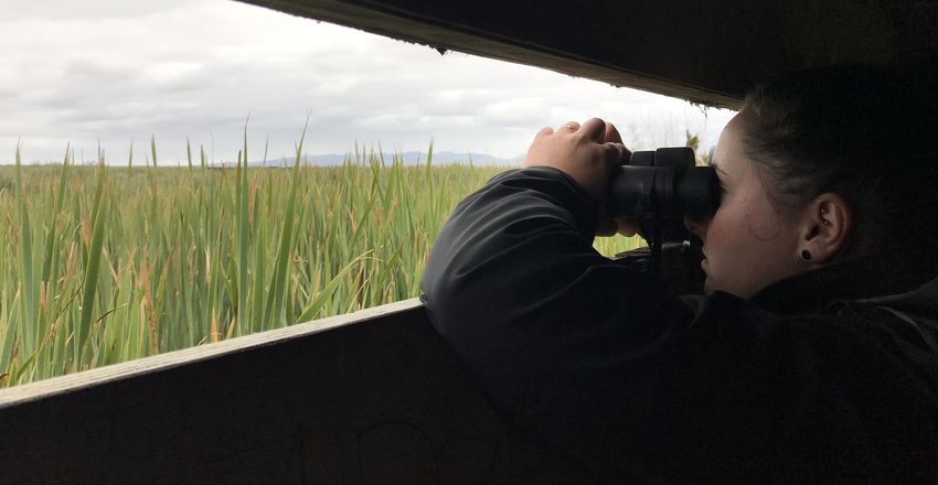
Front page photo: Bird watcher at the Harts Creek/Waitatari Bird hide on Lake Ellesmere/Te.
Photo: Frances Schmechel, Environment Canterbury.
i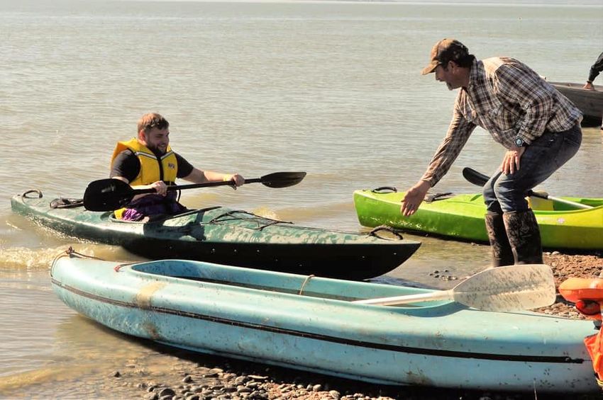
Recreation Monitoring Programme for Lake Ellesmere/Te Waihora

Table of Contents
Acknowledgements                  .......................................................................................................... i

Chapter 1          Introduction....................................................................................................... 1
                   1.1    Lake Ellesmere/Te Waihora Background .............................................. 1
                   1.2    Recreation at Lake Ellesmere/Te Waihora ............................................ 2
                   1.3    Purpose of Study................................................................................... 5
                   1.4    Approach............................................................................................... 6
                   1.5    Review of Literature .............................................................................. 6
                   1.6    Key Informant Discussions .................................................................... 7

Chapter 2          Literature Review.............................................................................................. 9
                   2.1     Outdoor Recreation Research ............................................................... 9
                   2.2     Monitoring and Understanding Recreational Use ................................ 10
                   2.3     Traditional Recreational Use Monitoring Methods ............................... 11
                   2.4     New Methods for Monitoring Recreational Use ................................... 14
                   2.5     Monitoring Recreational Use of Large Natural Open Spaces............... 17
                   2.6     Lake Ellesmere/Te Waihora as a Large Natural Open Space for
                           Recreation........................................................................................... 20
                   2.7     Attributes of Effective Recreational Use Monitoring within the Lake
                           Ellesmere/Te Waihora Context ............................................................ 21
                   2.8     Assessment of Data Attributes for Lake Ellesmere/Te Waihora ........... 24

Chapter 3          Recommendations.......................................................................................... 29
                   3.1  Recreation Monitoring Programme for Lake Ellesmere/Te Waihora .... 29
                   3.2  Recommended Future Research ........................................................ 36

Bibliography ....................................................................................................................... 39
Appendix A: Activity Types, Locations, Use Estimates and Sources of Use Data ............... 45
Appendix B: Lake Ellesmere/Te Waihora Lake Access Points, Infrastructure and
             Monitoring Possibilities ................................................................................... 49

Figures
Figure 1        Sailing Boats at Lakeside Domain. Photo: Ellesmere Aquatic Club ..................... 2
Figure 2        Map of Lake Ellesmere/Te Waihora with 13 key recreation sites indicated ......... 3
Figure 3        Harts Creek/Waitatari Bird Hide. Photo: Katie Nimmo ....................................... 12
Figure 4        Motorhomes at Lakeside Domain. Photo: RV Camper ...................................... 16
Figure 5        Kayaking at Lakeside Domain. Photo: Shane Epiha, Lake Ellesmere Aquatic
                Club .................................................................................................................. 19
Figure 6        Boating at Lakeside Domain. Photo: Shane Epiha, Ellesmere Aquatic Club .... 20
Figure 7        Hunting on Lake Ellesmere/Te Waihora. Photo: Richard Cosgrove, Fish and
                Game NZ .......................................................................................................... 24
Figure 8        Cycling the Little River Rail Trail. Photo: Robin Smith ....................................... 34

                                                                                                                                            ii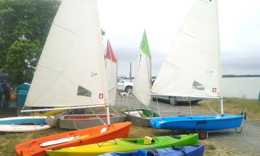
Recreation Monitoring Programme for Lake Ellesmere/Te Waihora

Tables
Table 1   Recreational Activities at key locations on Lake Ellesmere/Te Waihora .............. 4
Table 2   Seven types of visitor information (adapted from Booth 2006) ............................ 9
Table 3   Monitoring types and associated methods for monitoring visitor numbers ......... 11
Table 4   Characteristics of Lake Ellesmere/Te Waihora as a large natural open
          space setting..................................................................................................... 20
Table 5   Applicability of the five attributes of different monitoring data sources for
          effective recreational use monitoring at Lake Ellesmere/Te Waihora ................ 25
Table 6   Possible recreation monitoring programme for Lake Ellesmere/Te Waihora ..... 31

                                                                                                                            iii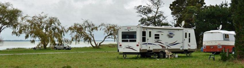
Recreation Monitoring Programme for Lake Ellesmere/Te Waihora
Executive Summary
The impetus for this study was the long- identified need for data about recreational use
of Lake Ellesmere/Te Waihora – New Zealand’s largest coastal lake, and an area
increasingly recognised for its cultural, environmental, scientific and recreation values.
While the recreational use of Lake Ellesmere/Te Waihora is already well-recognised,
there is only limited published data about this use and, as yet, no documented effort to
coordinate data into a coherent form that might allow use trends and their implications to
be assessed.
An intentional and important parameter for this study was its focus on ‘monitoring’ rather
than on ‘research’ – hence the report’s emphasis on approaches associated with
measuring indicators to establish baselines and determine changes in patterns of use
over time.
The study employed a literature scan, discussions with key informants and a workshop
to elucidate key principles applied in the collection of recreation use data, and find
examples of monitoring approaches used in large, natural open space recreation
contexts.
The literature review revealed a range of methods for monitoring use of recreation
settings, including direct observations, on-site counters, visitor registrations and inferred
counts. Each of these approaches is described and evaluated in this report, and
ultimately considered in relation to its applicability to Lake Ellesmere/Te Waihora.
The report gives specific emphasis to monitoring the recreational use of large, natural
open spaces – where visitation is typically widely dispersed, and often varied in
character, leading to challenges in determining levels of use across space and time. The
literature confirmed a dearth of published examples documenting recreation monitoring
in such settings and, in particular, their application in coastal, marine or freshwater
recreation contexts.
Lake Ellesmere/Te Waihora has many of the characteristics and complexities associated
with large, natural open settings, including: multiple identifiable recreation sites and
activities and large distances between sites; multiple access points; infrequent visitation;
considerable non-recreation human use; complex governance; and highly variable
environmental conditions. These factors were carefully considered as part of determining
an appropriate recreation monitoring programme.
Information from the literature review and key informant discussions was used to distil a
set of attributes for effective recreation monitoring within the Lake Ellesmere/Te Waihora
context. Attributes were determined at both the programme and data-specific scales:
o At the programme level, recreation monitoring design ought to be: i) suited to the
specific context; ii) simple to implement (cost-effective, practical and feasible long-
term); iii) representative and flexible (accommodating of diverse activity types and
the possibility of new or unanticipated uses); and iv) supported by those agencies
and organisations who have invested resources in the collection of data gathered
under the programme
o At the data-specific scale, five key attributes were determined. Data ought to be: i)
quantifiable; ii) reliable; iii) valid; iv) accessible; and v) enduring.
Known Lake Ellesmere/Te Waihora recreation data sources were then assessed against
the identified criteria in order to recommend a possible recreation monitoring
programme. The study identifies seven recreation activities (and their data sources, likely
iv
Recreation Monitoring Programme for Lake Ellesmere/Te Waihora
data granularity and recommended data collection timeframe) most suitable for on-going
measurement and collation.
The report concludes with the identification of the next steps towards implementation of
the proposed recreation monitoring programme, future considerations that might
influence the composition of the monitoring programme, and further research that could
add depth to understanding the recreation dimension of Lake Ellesmere/ Te Waihora.
Exploring the association of the cultural dimension of Te Waihora and the lake’s
recreation values is an area that could be a useful focus of future research.
v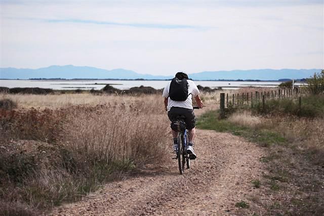
Recreation Monitoring Programme for Lake Ellesmere/Te Waihora

Introduction
1.1 Lake Ellesmere/Te Waihora Background
Lake Ellesmere/Te Waihora1 is New Zealand’s largest coastal lake, and the country’s fifth
largest overall. Situated around 30km from Christchurch city, the lake covers an area of
approximately 20,000 ha (Hughey, Johnston, Lomax & Taylor, 2013). The lake is of
international significance for its birdlife (Hughey et al., 2013) and is a rich biological
environment that hosts indigenous plant and fish species (Hughey et al., 2013). Lake
Ellesmere/Te Waihora is of high cultural significance for Ngāi Tahu, with the lake long being
valued as a mahinga kai site and an important source of mana (Hughey et al., 2013). The
importance of the lake’s wildlife habitat, wetland vegetation and fish, as well as its
significance for Ngāi Tahu history, mahinga kai and customary fisheries, have been
recognised by a National Water Conservation Order that seeks to legislatively protect these
values (National Water Conservation (Te Waihora/ Lake Ellesmere) Order 19902).
Lake Ellesmere/Te Waihora has a complex management structure. Seven agencies hold
statutory or other regulatory responsibilities for the lake; Ministry for Environment, Ministry
for Primary Industries, Department of Conservation, Environment Canterbury, Selwyn
District Council, Christchurch City Council and the Canterbury District Health Board. These
agencies work in consultation with other non-statutory organisations, interest groups and
industry partners including Fonterra, the Waihora Ellesmere Trust, Te Ara Kakariki,
universities and other organisations and stakeholders invested in the Lake (Espiner, Stewart
& Lizamore, 2017).
Approximately 70 per cent of the lake margin is owned or administered by the Department of
Conservation, Te Rūnanga o Ngāi Tahu, Selwyn District Council, Environment Canterbury,
or Christchurch City Council (Ford et al., 2017). Other margin areas and parts of the lake
bed are under private ownership. Under the Ngāi Tahu Claims Settlement Act 1998,
ownership of much of the lake bed that was in Crown reserves was returned to Te Rūnanga
o Ngāi Tahu.
Management of the lake and its margin areas is also informed by the Te Waihora Joint
Management Plan/Mahere Tukutahi o Te Waihora, a statutory document prepared by Ngāi
Tahu and the Department of Conservation containing objectives, policies and methods for
effective integrated management of the Ngāi Tahu lake bed and surrounding margins
managed by the Department of Conservation (Te Rūnanga o Ngāi Tahu and Department of
Conservation, 2005). In most respects management is controlled by provisions of the

1Although in recent times often referred to as Te Waihora/Lake Ellesmere, the official gazetted place
name is “Lake Ellesmere (Te Waihora)”. We have opted for the naming approach used by the local
community in its Lake Strategy (Lake Ellesmere Issues Group, 2004) and adopted by the Waihora
Ellesmere Trust (a community trust monitoring and advocating the implementation of the community
strategy for the Lake.
2Originally named the National Water Conservation (Lake Ellesmere) Order 1990, the Order was
amended, with additional values to be protected, and renamed, in 2011. (Parliamentary Counsel
Office, 2020)

                                                                                                        1
Recreation Monitoring Programme for Lake Ellesmere/Te Waihora
relevant regional and district policies and plans (e.g., the Regional Policy Statement,
Regional Coastal Environment Plan, the Land and Water Regional Plan, the Selwyn District
Plan and the Christchurch City Plan) or wildlife and fisheries regulations.
1.2 Recreation at Lake Ellesmere/Te Waihora
Figure 1 Sailing Boats at Lakeside Domain. Photo: Ellesmere Aquatic Club
Since the 1880s Lake Ellesmere/Te Waihora has provided a wide range of outdoor
recreation opportunities, and is identified as a potentially nationally significant water body for
recreation (Ministry for the Environment, 2004). Recreational activities that are known to
occur on the lake and its margins are: fishing (for trout, flounder/pātiki, eel/tuna,
whitebait/inanga), gamebird hunting, water sports (swimming, kayaking, sailing, power-
boating, windsurfing), walking, cycling, bird watching, photography, camping, picnicking
(Hughey, 2013), geocaching, 4-wheel driving, educational activities (Espiner et al., 2017),
and volunteerism (Booth, 2009).
Recreational use of Lake Ellesmere/Te Waihora is highly dispersed, with many different
individual recreation sites and points of access existing around the lake (Espiner et al.,
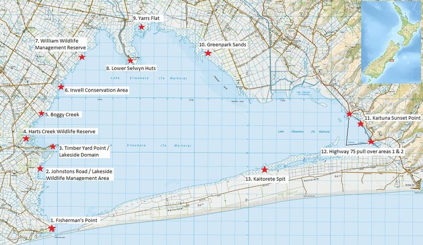
2017). Figure 3 (page 3) shows the 13 key sites around Lake Ellesmere/Te Waihora where
recreational activities are known to occur. Table 1 (page 4) provides a summary of the
nature of recreational use of the key recreation sites.
2Recreation Monitoring Programme for Lake Ellesmere/Te Waihora
Figure 2 Map of Lake Ellesmere/Te Waihora with 13 key recreation sites indicated3
3
# 12 refers to two sites that are regularly used by photographers.
3Recreation Monitoring Programme for Lake Ellesmere/Te Waihora
Table 1 Recreational Activities at key locations on Lake Ellesmere/Te Waihora
Activity Preferred locations for activities
Gamebird hunting Kaituna Lagoon to Lakeside Domain, particularly at Greenpark
Sands stretching up to Harts Creek/Waitatari
Trout angling Main river mouths: Selwyn River, Harts Creek/Waitatari, Irwell, Lll,
Halswell
To a lesser extent Kaituna and Boggy Creek
Eeling Not reported
Whitebaiting River mouth of LII and Selwyn River
Floundering Greenpark Sands, Some placing of nets at Timberyard Point
Boating (including Kitesurfing and windsurfing: Lakeside Domain
windsurfing and Some windsurfers use the northern side of the Lake at Greenpark
kite surfing) Sands to do their “speed runs”
Rowing and Kayaking: Selwyn River, Lakeside Domain
Water-skiing and jet-skiing: Lakeside Domain
Sailing: Lakeside Domain
Cycling Rail Trail
Birdwatching Harts Creek/Waitatari Bird Hide, Kaituna Sunset Point, Greenpark
Sands, Many locations around the lake
Photography Pull over areas on SH75, Harts Creek/Waitatari, Many areas around
lake for scenic landscape capturing
Picnicking Lakeside Domain, Harts Creek/Waitatari, Selwyn Delta, Kaituna
Sunset Point, Fishermans Point, Kaitorete Spit, Greenpark Sands
Walking Harts Creek/Waitatari, Yarrs Flat, Kaituna Sunset Point, Lower
Selwyn Huts
Camping Lakeside Domain (camping also occurs at nearby at popular Coes
Ford Recreation Reserve, as well as Chamberlains Ford Recreation
Reserve, 3km and 7km away from the lake respectively)
Geocaching Determined by location of geocaches which evolve over time
4WD Greenpark Sands, Yarrs Flat, Taumutu, up the stopbanks and on
the mud during low lake levels
Educational Various sites around lake
Volunteering Tree planting, site maintenance and predator trapping at various
locations around lake
Lake opening Viewing of lake opening from Fisherman’s Point and end of
Kaitorete Spit
See Appendix A of this report for further information on these activities, including recent
estimates of recreational use, existing potential data sources, and possible future data
sources.
Lake Ellesmere/Te Waihora is traditionally an important source of mahinga kai to Ngāi Tahu.
Mahinga kai encompasses the social and educational elements of food gathering (Te
Rūnanga o Ngāi Tahu and Department of Conservation, 2005) and participation in mahinga
kai activities, such as the collection of swan eggs, remain important today. While this report
does not specifically cover mahinga kai, it is noted that exploring the association of the
cultural dimension of Te Waihora and the lake’s recreation values is an area that could be a
useful focus of future research.
The need for recreational user data to aid recreation management and connection with the
Lake was among actions identified through a two–year extensive community consultation
process ending in 2004 with an agreed Community Strategy for the Lake (Lake Ellesmere
Issues Group, 2004). Collecting such data was included in the first ten-years of action in the
Strategy. However the complexities of data collection proved to be problematic, due to the
4Recreation Monitoring Programme for Lake Ellesmere/Te Waihora
numerous agencies with overlapping monitoring responsibilities and no mechanism to bring
the data together in a way that informs community and decision makers (Waihora Ellesmere
Trust, 2014). An integrated monitoring strategy for Lake Ellesmere/Te Waihora was
developed, initially by the Waihora Ellesmere Trust, following feedback from the 2013 Living
Lakes Symposium and its implementation is led by Trustee Prof. Ken Hughey from Lincoln
University and the Waterways Centre for Freshwater Management. The strategy seeks to
monitor a range of values present at Lake Ellesmere/Te Waihora that would enable regular
measurement and reporting to help evaluate the effectiveness of management and to report
on the state of the lake (Hughey, 2016). Recreation at Lake Ellesmere/Te Waihora is one of
the values encompassed by the integrated monitoring strategy.
While the significance of Lake Ellesmere/Te Waihora for recreation is widely recognised,
Hughey (2013) has highlighted that there is very little quantitative information about trends in
recreational use and as such recommended that a system for measuring user days per
annum for the different activities occurring on and around Lake Ellesmere/Te Waihora be
established.
The need to understand recreational use of lake and wetland environments is also
recognised by the Canterbury Water Management Strategy (CWMS), a collaborative
framework launched in 2009 and used by Environment Canterbury to guide sustainable
management of Canterbury’s water bodies (Canterbury Mayoral Forum, 2010). A positive
trend in the availability and quality of recreational opportunities is a key target in the CWMS,
including a target for 2020 of better mapping and understanding of recreational opportunities
currently available.
A further need for information on recreational use of Lake Ellesmere/Te Waihora was
identified in a recent Environment Canterbury review of freshwater-based recreation and
amenity values in the Canterbury region (Cessford & Jones, 2018). The review identified a
gap in the understanding of the level of recreational use of, and information about,
recreationists in lake and estuary environments in the Canterbury Region, within which Lake
Ellesmere/Te Waihora is situated.
1.3 Purpose of Study
The purpose of this study was to explore and document a set of attributes with the potential
to inform the development of a robust, fit-for-purpose recreation monitoring programme for
Lake Ellesmere/Te Waihora. Such a programme will allow for longitudinal data capture to
increase understanding of the recreational use of the lake and its margins.
The data obtained will enable the establishment of a baseline understanding and create the
opportunity for regular measurement and reporting of long-term patterns and changes in
recreation use. This will help lake managers evaluate the impact of lake management
decisions on recreational use and support lake stakeholders to make well-informed
decisions plus maintain and develop quality visitor experiences.
Development of such a recreation monitoring programme marks a step towards contributing
recreation monitoring data to the Lake Ellesmere/Te Waihora integrated monitoring strategy
(Hughey, 2016).
5Recreation Monitoring Programme for Lake Ellesmere/Te Waihora
1.4 Approach
The approach used for this study involved three stages:
1. A detailed review of the recreation monitoring literature, with a focus on recreation
monitoring methods and monitoring in large natural open spaces.
2. A series of ‘key informant’ discussions with selected individuals and groups
knowledgeable about recreation at Lake Ellesmere/Te Waihora.
3. A synthesis of the literature review and informant discussions, to allow the development
of a suitable recreation monitoring programme that allows for longitudinal data capture
to inform understanding of the recreational use of Lake Ellesmere/Te Waihora.
1.5 Review of Literature
To gain an understanding of the current monitoring practices used locally and internationally,
it was necessary to undertake a wide-ranging review of the recreation monitoring literature.
In the past, some studies have used systematic literature reviews to summarise and assess
the state of knowledge on a given topic (Ford, Berrang-Ford & Paterson, 2011; Spector,
Cradock-Henry, Beaven & Orchiston, 2019; Thomsen, Powell & Monz, 2018). These reviews
used systematic and explicit methods and criteria to select relevant results, such as:
searching particular databases, limiting the search to peer-reviewed articles, limiting the
search to a certain date range, using defined key words for searches.
Given the purpose of the current review was to gain a holistic understanding of recreation
monitoring practices being used in a variety of contexts, in this case a less prescribed
approach was taken, consistent with the study’s exploratory aims. Notwithstanding this,
some parameters for the literature search are possible to define.
Five main electronic databases were used to gather references:
CAB Abstracts
Web of Science
ScienceDirect
SpringerLink
Google Scholar
Database searches involved terms relating to ‘recreation monitoring’ in general and
‘monitoring’ in ‘dispersed/open/coastal/wetland/marine environments’.
An internet search was also used to source non-academic reports and documents. Hughey
& Coleman (2006) acknowledge the usefulness of internet-based scans for the detection of
government or NGO reports that would not otherwise be picked up in academic database
searches. Recreation monitoring information may be recorded as part of studies targeting
other issues, for example studies looking primarily at ecological management of a recreation
area (e.g., Dennis, Davies, Thomson & Barnes, 2005). There is potential for such studies to
be overlooked in typical scholarly online searches.
6Recreation Monitoring Programme for Lake Ellesmere/Te Waihora
1.6 Key Informant Discussions
Discussions (in the form of a workshop and one-on-one interviews) with key informants were
held to complement the review of the literature and to gain some local knowledge about the
Lake Ellesmere/Te Waihora environment. 4
Selection of organisations and individuals for participation as key informants was based on
three criteria: i) the organisation’s or individual’s involvement in management of recreation
opportunities at Lake Ellesmere/Te Waihora; ii) the organisation’s or individual’s
representation for a particular activity or interest; iii) the organisation’s or individual’s
willingness and availability to participate in the study.
Key informants from the following organisations and groups participated in a workshop:
Department of Conservation
Environment Canterbury
Selwyn District Council
Waihora Ellesmere Trust
Fish & Game New Zealand
Some key informants could not attend the workshop, but contributed through one-on-one
interviews. These included representatives from:
Christchurch City Council
Ellesmere Lions Club
Ellesmere Aquatic Club
Fish & Game New Zealand
Lincoln University (post graduate students and recreation or tourism experts)
Their contributions are attributed as “Personal Communication” in this report.
Key informants were asked to contribute their knowledge in relation to the following areas:
1. Types of recreation activities occurring at Lake Ellesmere/Te Waihora and particular
locations where activities take place
2. Possible recreation use data sources (both existing datasets and possible future ones)
that could be used as indicators for the monitoring programme
3. Perceptions of what would be appropriate monitoring methods for Lake Ellesmere/Te
Waihora and attributes of effective monitoring in that environment
4. Development of a Monitoring Programme for Recreational Use of Lake Ellesmere/Te
Waihora
The data generated through the literature review and from key informant discussions was
synthesised and used to inform the development of a suitable recreation monitoring
programme and a suite of recommendations with the potential to provide a longitudinal
recreational use dataset for the lake and its margins.
4 All key informants consented to attribution of their names to comments in this report.
7Recreation Monitoring Programme for Lake Ellesmere/Te Waihora
8Recreation Monitoring Programme for Lake Ellesmere/Te Waihora
Literature Review
The review begins by providing an outline of outdoor recreation research in general, before
focussing more specifically on visitor monitoring methods – both traditional and more recent.
Previous approaches to monitoring recreational use of large natural open spaces are then
considered, before the specific case of Lake Ellesmere/Te Waihora is introduced. The
section concludes by outlining a set of attributes intended to aid in assessing the merits of
monitoring programmes and data sources potentially applicable to Lake Ellesmere/Te
Waihora.
2.1 Outdoor Recreation Research
Outdoor recreation research is described as experimental, theoretical or investigational work
that is undertaken to acquire new knowledge in regard to recreation occurring in natural
environments (Devlin, 1995).
Outdoor recreation research provides valuable information to recreation managers, with data
collected and collated as part of outdoor recreation research supporting many management
outcomes such as:
Measuring the success of management actions
Identifying demand trends
Relating use levels to social and physical impacts
Allocating infrastructure and services
Identifying the social, economic and political importance of the recreational use
Development of natural resource and recreation management policies
(Cessford & Burns, 2008; Schägner et al., 2017; Wardell & Moore, 2004).
Booth (2006), in a review of outdoor recreation research in New Zealand, presents a ‘Visitor
Research Framework’ which identifies seven different types of information that currently
exists in the New Zealand outdoor recreation research literature and is collected to inform
management of recreation areas. The ‘Visitor Research Framework’ was developed to
provide a common language for managers and researchers and represents a spectrum of
complexity in visitor research. The seven types of data described under the framework are
summarised in Table 2.
Table 2 Seven types of visitor information (adapted from Booth 2006)
Type Name of Type Summary of Type
1 Visit Numbers Type 1 data comprises of the number of recreational visits to a place
and represents the most basic type of visitor information. This type of
data can provide information on how many people visit a place and
where and when the visit occurred
2 Visit and Visitor Type 2 data builds on Type 1 data to describe the nature of the
Characteristics recreational use and users, providing information on who the visitor is,
what they are doing, when they visit and what facilities they use
3 The Visitor Type 3 data explains the recreational behaviour by exploring concepts
Experience such as visitor perceptions, expectations, motivations and
satisfactions
9Recreation Monitoring Programme for Lake Ellesmere/Te Waihora
4 Visitor Impacts Type 4 information concerns the negative outcomes of recreation use,
with adverse effects being social, economic or environmental
5 Recreational Type 5 information concerns the positive outcomes from recreation
Benefits use. These benefits may occur on-and-off site and at different scales
such as benefits to the environment, the individual, the community and
the nation
6 Recreation Type 6 information involves the recreational demand and for
Resource Demand recreational resources from visitors, this demand may be real or yet
and Supply unrealised. Information about the supply of recreational opportunities
can be explored as part this
7 Recreation Type 7 information explores the role of management actions in the
Management recreation experience
Processes and
Techniques
Booth’s (2006) framework makes it clear that managers require information about
recreational use at very different levels. Each type of data serves distinct purposes, and
sophistication and complexity increases markedly between types 1 and 7.
2.2 Monitoring and Understanding Recreational Use
While outdoor recreation research involves investigations and acquiring new knowledge,
outdoor recreation monitoring is the actual process of observing and measuring indicators to
understand baselines and detect change and patterns over time (Hadwen, Hill & Pickering,
2008). This gathering of information on recreation use patterns is often collectively referred
to as ‘visitor monitoring’ (Cessford & Burns, 2008).
While many different types of information can be ascertained through visitor monitoring, it is
monitoring visitor numbers to a place (Type 1 data as referred to by Booth, 2006) that is
arguably the most important and fundamental aspect of recreational use to monitor
(Cessford & Burns, 2008; Hornback & Eagles, 1999; Schägner et al., 2017; Wardell &
Moore, 2004).
Type 1 data provides a baseline understanding of how many people visit an area. Once
baseline visitor data is established, changes in visitor numbers can be detected and the
impact of management interventions can subsequently be measured (Cessford & Burns,
2008). More granular spatial observational monitoring of visitors may record (within an open
place) data on types of recreational activities relevant to environmental management and
planning (e.g., Bouma, Robertson, Rennie & Oulton, 2007; Robertson & Rennie 2006;
Thomson 2003).
It is primarily Type 1 data (Visit Numbers) that this report will consider, given the importance
of this data in establishing a baseline understanding of how many people are using Lake
Ellesmere/Te Waihora and its margins for recreation activities and which activities are being
undertaking where. While not the focus here, it is important to emphasise that higher level
data (such as why people visit, where they are from, their perceptions and impacts) are also
critical in helping to develop a comprehensive picture of outdoor recreation. The foundational
step in visitor monitoring, however, is the number of people who visit and where those visits
occur.
10Recreation Monitoring Programme for Lake Ellesmere/Te Waihora
2.3 Traditional Recreational Use Monitoring Methods
Various methods of monitoring visitor numbers have been used to understand recreational
use patterns (Cessford & Burns, 2008; Cope, Doxford & Millar, 1999; Hornback & Eagles,
1999; Robertson & Rennie, 2006). Cessford & Burns (2008) describe these methods as
falling into four distinctive types of monitoring.
These monitoring types and associated methods are described in Table 3 and further
discussed below.
Table 3 Monitoring types and associated methods for monitoring visitor numbers
Monitoring Type Methods Method Description
Direct Field observers People on-site who manually record visitor dat
observation Camera recordings Video recordings or photos of visitors on-site,
manually reviewed to collect visitor data
Remote sensing Aerial photography or imagery from satellites or
aircraft that show visitor presence and
distribution at specific times
On-site counters Mechanical or Devices placed on-site to record the passage of
electronic counters visitors who activate a trigger and record a
‘count’ when passing the device
Visit registration Visitor book/register Voluntary or compulsory self-registration of visit
in book/register
Permits Use of existing administrative system such as
permits to enter an area or undertake an activity
to gain visitor information
Inferred counts Survey or interview Undertaking of visitor surveys or interviews to
counts gain visitor information
Use of ‘indicators’ such Use of existing information as ‘indicators’ to infer
as vehicle counts visitor information
2.3.1 Direct Observations
Field Observations
Field observations are accurate and can include descriptive data in addition to basic visitor
number counts (Cessford & Burns, 2008). It is a well-used traditional method of monitoring
both in New Zealand (Thomson, 2003) and overseas (Hornback & Eagles, 1999). Given the
accuracy of this method, having observers on-site is the preferred method for calibrating
other counts (Schwartz, Stewart & Backlund, 2010).
Camera Recordings
Use of photographs or video recordings can be an accurate and flexible method and an
alternative to on-site field observers (Manning, 2014). Fairfax, Dowling & Nelder (2014) used
digital cameras triggered by movement sensors to capture photographs of different track
users. They describe the monitoring method to be relatively low cost over time and helpful in
its ability to differentiate different types of activities occurring in one location.
Remote Sensing
Remote sensing can be used to monitor over large areas, providing a snapshot in time of the
spatial extent of visitors in an area. Smallwood, Beckley, Moore & Kobryn (2011) used
overflights by a small aircraft over a 12 month period to conduct aerial surveys of Ningoloo
Marine Park off the north-western coast of Australia. The aerial survey provided information
11Recreation Monitoring Programme for Lake Ellesmere/Te Waihora
on numbers of recreationists, the type of activity they were engaged in and the spatial
distribution of users.
2.3.2 On-Site Counters
On-site counters are one of the most common methods used to collect visitor numbers data
(Booth, 2006), being used widely around the world to record visit numbers (Cessford &
Muhar, 2003). There are a variety of counter types in existence. Physically activated
counters include mechanical counters on a gate or door (activated by the physical opening)
and pressure counters on a path (activated by being stepped on). Active and passive optical
counters are triggered by the interruption of infra-red signals by a passing visitor. Magnetic
sensing counters and microwave sensing counters are activated by changes in magnetic
fields and radio waves respectively, and are primarily used to count vehicles.
The various counter types all have advantages and disadvantages, so a range of
considerations should be taken into account when choosing a counter type, including:
susceptibility to false counts by wildlife or tree branches etc., ability to conceal counter to
limit interference by visitors, cost, level of information recorded (time and date etc.), ability to
differentiate between different uses (e.g. vehicles, bikes, people), power consumption and
sensitivity to environmental conditions (e.g. temperature) (Cessford & Burns, 2008).
2.3.3 Visitor Registration
Self-Registration
Self-registration is a simple method that can be used to collect visitor number data, along
with additional data including visitor profile and trip information (Watson, Cole, Turner &
Reynolds, 2000). For example visitors to the Harts Creek/Waitatari bird hide are currently
invited to register their presence at the hide in a visitor’s book. The method can be used to
produce long-term data, as some types of registrations (such as hut books) have a long
history (Cessford & Burns, 2008).
Figure 3 Harts Creek/Waitatari Bird Hide. Photo: Katie Nimmo
The reliability of this method can vary when used on a voluntary basis, as not all visitors will
register if they do not have to. While an effective self-registration system will have a
12Recreation Monitoring Programme for Lake Ellesmere/Te Waihora
sufficient rate of visitor registration, if the proportion of visitors who choose to register is
relatively consistent over time, the method may still be able to produce useful trend data with
lower rates of registration (Cessford & Burns, 2008).
The rate of registration can vary across sites, being most effective in areas used by a few
visitors who are very interested in nature conservation subjects (Vuorio, Emmelin & Sandell,
2003). Furthermore, visitor registration is more effective when the registration site is placed
part way along a trail where users are likely to stop at points of interest, a scenic view, a
stream crossing, the top of a hill (Watson et al., 2000).
Due to the variation in registration rates with this method, ongoing calibration is required to
provide estimations of registration rates (Cessford & Burns, 2008).
Permits
Data on the use of permits and other administrative records is relatively accurate and can be
simple to acquire, but can only be used for situations and activities where permits are
required or other records kept. It is often possible to acquire additional information about the
user and activity, such as visitor age or origin, which is collected as part of the existing
permit registration process (Cessford & Burns, 2008).
2.3.4 Inferred Counts
Survey or Interview Counts
Visitor surveys or interviews can be used to obtain a range of visitor information, as visitors
can be asked any questions desired. Visitor number estimates can be gathered (Type 1 data
as referred to by Booth, 2006) as well as more in depth information about visitor
characteristics/experience and recreation impacts, benefits, demand and the impact of
management actions (information types 2-7 as referred to by Booth, 2006). Surveying
requires careful sampling and survey design to ensure a representative sample is taken and
effective questions are asked (Cessford & Burns, 2008).
Surveys and interviews can be undertaken on-site (field surveys) or off-site
(online/postal/phone surveys).
Indicator Counts
Recreation use can be estimated by measuring proxy ‘indicators’ rather than counting
visitors directly. This method can help take advantage of existing information and measures
linked to visitor use that may be more easily accessible than direct visitor counts. Indicators
that have been used as proxy variables for visitor counts include: vehicle counts (Ziesler &
Pettebone, 2018), ticket sales (English et al., 2003), accommodation use (Kelly, Williams,
Schieven & Dunn, 2006), weather conditions, the economy, media attention (Millhäusle,
Anderwald, Haeni & Haller, 2016), amount of damaged vegetation (Cole, 2004), campsite
size, amount of rubbish, number of campfires (Wolf, Hagenloh & Croft, 2012), number of
information brochures taken and transport service use (Watson et al. 2000).
The use of indicator variables requires extensive calibration effort and precision is low in the
absence of this (Cessford & Burns, 2008). Calibration can be undertaken by taking a sample
measure of both recreation use and the level of some variable that can serve as a proxy for
visitation. Analysis then establishes the relationship between the visitation proxy variable
and actual visitation. Applying the relationship that has been estimated from the sample to
the annual or seasonal total count of whatever proxy variable is used gives the total visitation
estimate (English, Kocis, Arnold, Zarnoch & Warren, 2003).
13Recreation Monitoring Programme for Lake Ellesmere/Te Waihora
The practicality of using indicator counts varies across sites. While some sites may not have
any suitable indicator variables, others can utilise indicator variables for successful
estimation of recreation visitation (Wagar, 1969, as cited in English et al., 2003, p. 333).
Many recent studies that have successfully used proxy variables for visitation have been at
sites that are either developed that have facilities such as visitors centres (Ziesler &
Pettebone, 2018) or ski fields (English et al., 2003) or have high levels of visitation (Kelly et
al., 2006; Millhäusle et al., 2016). Having such developments onsite mean that there are
more opportunities to select proxy variables that are closely related to actual visitation and
as such have more effective proxy variables (Wagar, 1969, as cited in English et al., 2003, p.
333). High levels of visitation mean more ‘traces’ left by visitors that can be monitored (such
as amount of rubbish left behind or number of brochures taken) and levels of visit data that
meet data requirements for some types of methods (Kelly et al., 2006).
2.4 New Methods for Monitoring Recreational Use
While a review of the literature indicates that the traditional methods outlined above are the
predominant ways of collecting monitoring data, a number of new approaches to recreation
monitoring are being trialled and applied. Three new key methods of data collection are
apparent in the literature and are discussed below: use of drones, mobile phone app-based
information and mobile phone positioning data.
Cessford & Jones (2018), in a review of freshwater-based recreation values in the
Canterbury region, recommend developing broader and more consistent use estimation
techniques and systems to address the identified information gap for lake-based recreation
and user information. They highlight that innovative technologies and new monitoring
approaches such as mobile phone tracking, app-based information and use of drones,
appear to have potential and should be considered as part of the development of a
systematic baseline monitoring approach.
2.4.1 Drones
The use of drones to collect aerial imagery represents a newer form of remote sensing, a
‘direct observation’ monitoring type as described in Table 2 above. Drones can be much
more versatile, cost effective and offer higher resolution imagery than traditional methods of
gaining aerially imagery via aircraft and satellite (Ancin-Murguzur, Munoz, Monz & Hausner,
2019; Utomo, 2019).
Ancin-Murguzur et al. (2019) used drones to monitor visitor numbers is a large urban park.
They concluded that drones can be a reliable and valid tool for counting visitors, classifying
visitors (age group, gender, activity engaged in) and recording spatial patterns of park use.
In comparison to traditional on-the-ground monitoring, drones can cover a larger
observational area and collect data in ways that a human observer cannot because of
accessibility or practicality for activities such as lake/stream use, rock climbing or walking on
long/convoluted trails.
Drones have already been successfully used in environmental monitoring on the margins of
Lake Ellesmere/Te Waihora. Fake (2019) used drone imagery to monitor plant communities
at Kaitorete Spit Scientific Reserve and drone imagery is also currently being used to
monitor damage caused by vehicles on the Greenpark Sands area of Lake Ellesmere/Te
Waihora (J. Blakely, pers. comm., September 18, 2019).
14Recreation Monitoring Programme for Lake Ellesmere/Te Waihora
While drone based monitoring technology is constantly developing and is currently used in
some recreation contexts, there are limitations with the technology. There is a lack of ethical
and practical experience on work with drones in recreational management and potentially
significant issues around effects on wildlife (Wallace, Martin & White, 2018). The presence of
drones can be considered a threat to people’s privacy and in some environments may affect
the quality of peoples' recreational experiences or disturb wildlife (Dolesh, 2015). Other
limitations such as the cost of obtaining and running the drones (Ancin-Murguzur et al.,
2019) may mean the technology is more suited for occasional/periodic monitoring.
2.4.2 Mobile Phone Based Techniques
Mobile phone based technologies are becoming increasingly present in the outdoor
recreation monitoring literature (Pickering, Rossi, Hernando & Barros, 2018). Mobile phone
based technologies represent a form of an ‘inferred count’ monitoring type as defined in
Table 2. Data gathered from use and presence of phones creates a new kind of indicator
from which visitor information can be inferred.
App-Based Information
Geotagged photos on phone applications such as flickr5 have been explored as a proxy for
visitation numbers to natural areas. While use of mobile apps for data collection is still at the
experimental stage (Muñoz et al., 2019; Pickering et al., 2018), some studies have found
geotagged photos to be a useful proxy for visitation (Keeler et al., 2015; Levin, Lechner &
Brown, 2017; Muñoz, Hausner & Monz, 2019; Orsi & Geneletti, 2013; Walden-Schreiner,
Rossi, Barros, Pickering, & Leung, 2018; Wood, Guerry, Silver & Lacayo, 2013). Of
particular note, Wood et al. (2013) compared observational visitation data collected from 836
recreational sites in 31 countries with data generated from geotagged photographs uploaded
to flickr. The study found a reliable statistical relationship between the number of people
counted and the flickr-generated estimate of user-days and the authors therefore conclude
that the crowd-sourced information can indeed serve as a reliable proxy for more traditional
and time intensive empirical counts.
A number of limitations of this method have been identified. Visitation rates to an area may
be too low to result in a suitable density of geotagged photos (Orsi & Geneletti, 2013) and
different recreational activities may be more or less suited to taking photographs (Wood et
al., 2013). Also, the perceived value of a trip may influence whether people take or share
photographs, resulting in a bias against images from visitors who travel shorter distances
from home (Wood et al., 2013). Much technical analysis and calibration is also required for
this method (Orsi & Geneletti, 2013; Walden-Schreiner et al., 2018).
Metadata from mobile phone applications can also be used to gain visitor use estimates.
Some applications track user’s locations and collect other visitor data such as user
demographic information. Campermate is a widely used application in New Zealand, which
collection a variety of data from users. Data from the Campermate application has recently
been used to inform visitor research (pers. comm., D. Simmons, October 30, 2019).
5 https://www.flickr.com/
15Recreation Monitoring Programme for Lake Ellesmere/Te Waihora
Figure 4 Motorhomes at Lakeside Domain. Photo: RV Camper
Other types of mobile applications are used to collect ‘citizen science’ data, whereby
members of the public upload observations to the database. eBird6 is one example of a
citizen science based application, where members contribute by collecting data on the
distribution and abundance of birds through uploading sightings to the database (Sullivan et
al., 2014). Given that location is logged as part of the bird sighting, such data could be used
as a monitoring indicator for birdwatching in the area.
Mobile Phone Positioning
Visitor location data can also be obtained through monitoring the positioning of mobile
phones, such as data collected from phone companies which store the location of mobile
phones based on data captured by proximate cell phone towers. This method has been used
to study the geographical distribution of international visitors (Ahas, Aasa, Roose, Mark &
Slim, 2008) and suggested as a possibility for use in monitoring visitor numbers to outdoor
recreation areas (Hansen, 2017).
The method would require extensive calibration in order for researchers to differentiate
between recreational and all other uses. Use of mobile phone positioning also presents
issues around privacy and transfer of information from network companies to third parties
(Ahas et al., 2008). Finally, to work well, the method would require sufficient network
coverage and reception in order to acquire precise results in remote areas (Hansen, 2017).
Mobile phone data is already being used in New Zealand to provide information on the
number of people in an area within a given timeframe. Data Ventures, a New Zealand “data
trust” that operates as a commercial arm of Stats NZ, sources datasets from the major
mobile phone companies in New Zealand and analyses this data to capture the number of
people who are located in a given area at a given time . Data Ventures currently offers a
‘Population Density’ product, where users can purchase information on the sum total of
mobile devices in an area down to the suburb resolution at any given hour. This information
is then used for purposes such as comparing days before and during an event, analysing
seasonal trends and emergency planning. Data Ventures has worked to address privacy
issues by receiving anonymised data from the mobile phone companies and only being able
to detect the total number of phones in a given area rather than track movement of an
individual phone (Data Ventures, 2019).
6 https://ebird.org/home
16Recreation Monitoring Programme for Lake Ellesmere/Te Waihora
2.4.3 Other ‘Big Data’ Tools
The New Zealand Ministry of Business, Innovation & Employment (2020) hosts the Regional
Tourism Indicators data set, which measures the change in level of expenditure of
international and domestic travellers in New Zealand. Whilst this data is aggregated to the
boundaries of the Selwyn District Territorial Authority and cannot identify the numbers of
travellers visiting Te Waihora, it does provide a general insight into the value of spending by
tourists in that district or region. If future recreation monitoring activities include ways to
identify the origin of visitors to key recreation sites around the lake, RTI data could be used
to roughly extrapolate how Lake Ellesmere/Te Waihora contributes to the local and national
economy via domestic and international tourism.
Finally, the University of Tasmania has developed a package of digital tools called “Tourism
Tracer” (https://tourismtracer.com/about/) which tracks tourists’ complete trips through a
destination at a large spatial scale (e.g. Tasmania, Sweden or Hokkaido). Data can be
collected according to age, home country, length of stay, and reason for travel. It also
collects data which records how long somebody stays at a particular location within the
country of destination (e.g. Lake Ellesmere/Te Waihora). However the tool is licensed and
will likely require funding from a range of stakeholders in New Zealand at a regional or
national level, plus considerable uptake by both domestic and international tourists in order
to provide relevant data about visitors to Te Waihora/Lake Ellesmere.
2.5 Monitoring Recreational Use of Large Natural
Open Spaces
The monitoring approaches outlined above have been applied in a range of recreation
settings. Some settings require special consideration because of their character, type or
level of use, with one such setting being large natural open spaces. Large natural open
spaces are vast natural outdoor settings in which dispersed recreation occurs, with
examples such as lakes, coastal and marine environments, wetlands and some terrestrial
areas such as wilderness areas or national parks.
Where urban, and often regional, park settings are frequently characterised by defined entry
and egress, clearly defined boundaries and sometimes supporting infrastructure, large
natural open spaces have multiple points of visitor access and limited or no containment
infrastructure leading to highly dispersed visitor patterns, making monitoring of visitors
difficult (Fisher et al., 2018; Hornback & Eagles, 1999; Vuorio, Emmelin & Sandell 2003;
Walden-Schreiner et al., 2012). Furthermore, the sheer size of large natural open spaces,
along with numerous types of recreational pursuits that the area can support, pose further
challenges for monitoring (Vrana, 1999).
While it is evident that some studies have explored visitor monitoring in large natural open
spaces, our review of the recreation monitoring literature determined that there is a dearth of
published examples specifically documenting the implementation of recreation monitoring in
such settings. Indeed, according to Hansen (2017), “studies that critically discuss challenges
and experiences regarding applied visitor monitoring methods in open coastal and marine
landscape settings hardly exist” (p. 282).
Pickering, Rossi, Hernando & Barros (2018) specifically highlight an information gap for
visitor monitoring and management in freshwater and marine protected areas and Blahna
(2005) describes an overall lack of examples of recreation monitoring in settings
characterised by dispersed visitor use.
17Recreation Monitoring Programme for Lake Ellesmere/Te Waihora
A review of the available literature suggests that most recreation monitoring is focused on
visitors within formalised park settings. Therefore the identified methods of monitoring
visitors have predominantly been applied and tested within these administrative settings.
Other settings appear largely absent from the literature. Pickering et al. (2018), for instance,
outline that despite the increasing size of marine protected areas globally and the high levels
of visitation to some of these areas, most research tends to focus on terrestrial natural
areas. In their analysis of 758 abstracts from the first seven International Monitoring and
Management of Visitors in Recreational and Protected Areas conferences, nearly all were
from terrestrial natural areas, with only 15 abstracts documenting visitor monitoring and
management in the context of freshwater and marine protected areas.
The dearth of information about monitoring recreation in large natural open spaces such as
marine and coastal areas, lakes and open forest/mountain areas is likely linked to the
additional monitoring challenges present in such settings - compared to monitoring within
many typical park settings (Hansen, 2017; Vrana, 1999; Walden-Schreiner, Leung,
Newburger & Woiderski, 2012).
Hansen (2017) explored what challenges can be identified from visitor monitoring in open
coastal and marine settings through designing and implementing a monitoring strategy for a
large coastal marine protected area in Sweden. Hansen (2017) used a mixed-method
approach, as one recreation monitoring method alone was not able to reach the dispersed
visitors in the open space: (1) an on-site questionnaire survey, (2) an on-site interview
survey and (3) a combination of on-site and roaming observations. The need for using a
mixed method approach in such open space was one of the key learnings identified by
Hansen. The primary challenges faced were unsuitable weather conditions and challenges
in acquiring a representative sample of recreationalists. Hansen noted that these challenges
were likely due to the nature of the open space context, being more exposed than other
environments to changing weather conditions and the greater dispersion of visitors across
the site making getting a representative sample challenging.
Walden-Schreiner et al. (2012) implemented visitor use monitoring in a large open meadow
setting of Yosemite National Park, where they developed and tested a method that they
present as accessible, replicable and acceptably accurate. The authors define ‘accessible’
as the method involving low-cost materials and being able to be implemented by volunteers
with varying levels of technical expertise, with an ‘accessible’ method allowing for greater
integration into other plans for open landscape monitoring that may be operating with limited
budgets or personnel resources, and providing the opportunity to engage community
partners in collection of managerially relevant data. ‘Replicable’ was identified as the method
being able to be replicated by volunteers and ‘acceptably accurate’ involved determining if
the proposed data uses were appropriate given the measured error. The method undertaken
consisted of unobtrusive direct observation by trained human observers, whereby volunteers
were trained to undertake visual scans of selected areas. This method is suggested as
applicable to other large natural open spaces, however it is specified that the method was
tested in a high-use area, therefore it is not known whether the method would be useful in
lower use areas.
In New Zealand, similar research found multiple longitudinal beach transects, comprising
observational counts of beach users with activity and location recorded by trained observers
and sometimes coupled with interview data, provided useable data in beach use studies in
the Waikato region (Thomson, 2003).
18You can also read