RMIT INTERNATIONAL UNIVERSITY VIETNAM INITIAL ENVIRONMENTAL EXAMINATION - MARCH 2000
←
→
Page content transcription
If your browser does not render page correctly, please read the page content below
RMIT INTERNATIONAL UNIVERSITY VIETNAM
 INITIAL ENVIRONMENTAL EXAMINATION

              MARCH 2000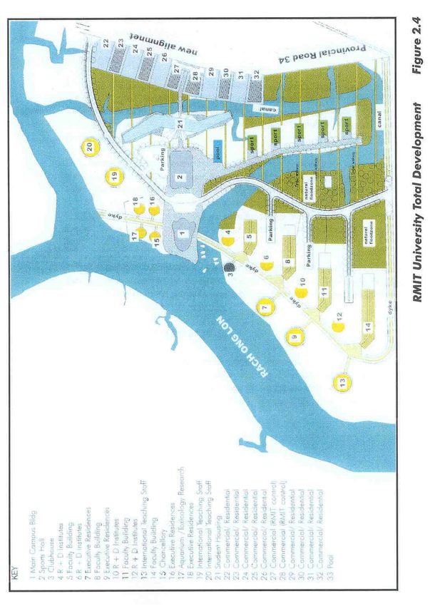
RMIT INTERNATIONAL UNIVERSITY VIETNAM
INITIAL ENVIRONMENTAL EXAMINATION

                                                 TABLE OF CONTENTS

Chapter 1 Introduction ...................................................................................................... 1
  1.1 General ...................................................................................................................... 1
  1.2 Legal Framework........................................................................................................ 1
  1.3 Extent of the Study ..................................................................................................... 2

Chapter 2 Description of the Project................................................................................ 4
  2.1 General ...................................................................................................................... 4
  2.2 Category of Project..................................................................................................... 5
  2.3 Need for the Project.................................................................................................... 5
  2.4 Project location...........................................................................................................6
  2.5 Size of the operation................................................................................................... 6
  2.6 Project Implementation............................................................................................. 12

Chapter 3 Description of the Environment ..................................................................... 8
  3.1 Physical Resources .................................................................................................. 16
    3.1.1 Introduction ...................................................................................................... 16
    3.1.2 Climate............................................................................................................. 16
    3.1.3 Topography...................................................................................................... 17
    3.1.4 Soils ................................................................................................................. 17
    3.1.5 Hydrology......................................................................................................... 18
    3.1.6 Ground and surface water:............................................................................... 19
    3.1.7 Geology ........................................................................................................... 20
    3.1.8 Air Quality ........................................................................................................ 20
  3.2 Ecological Resources ............................................................................................... 21
    3.2.1 Flora ................................................................................................................ 21
    3.2.2 Aquatic Organisms........................................................................................... 22
  3.3 Human and Economic Development ........................................................................ 24
    3.3.1 Human Development ....................................................................................... 24
    3.3.2 Current Infrastructure and Development Status ............................................... 25
    3.3.3 Land Use ......................................................................................................... 27
  3.4 Quality of life values ................................................................................................. 28
    3.4.1 Socio-Economic Values ................................................................................... 28
    3.4.2 Gender............................................................................................................. 28
    3.4.3 Archaelogical /Historical Treasures .................................................................. 28

Chapter 4 Screening of Potential Environmental Impacts and Mitigation Measures . 29
  4.1 General .................................................................................................................... 29
  4.2 Impacts due to Project Location ............................................................................... 31
    4.2.1 General ............................................................................................................ 31
    4.2.2 Resettlement.................................................................................................... 32
March 2000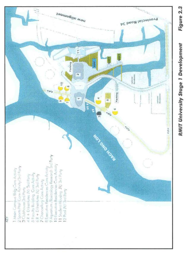
RMIT INTERNATIONAL UNIVERSITY VIETNAM
INITIAL ENVIRONMENTAL EXAMINATION

     4.2.3 Natural Ecosystems ......................................................................................... 32
   4.3 Impacts during Construction ..................................................................................... 33
     4.3.1 Project Earthworks ........................................................................................... 33
     4.3.2 Impacts on Soil and Water ............................................................................... 33
     4.3.3 Road Transport and Traffic .............................................................................. 33
     4.3.4 Air Quality ........................................................................................................ 34
     4.3.5 Agriculture........................................................................................................ 34
     4.3.6 Soils ................................................................................................................. 34
     4.3.7 Occupational Health and Safety....................................................................... 35
     4.3.8 Noise and vibration levels ................................................................................ 35
     4.3.9 Socio - Economic Impacts................................................................................ 36
   4.4 Impacts During Operation......................................................................................... 36
     4.4.1 Traffic............................................................................................................... 36
     4.4.2 Effluent Disposal .............................................................................................. 37
     4.4.3 Solid and Hazardous Waste Disposal .............................................................. 38
     4.4.4 Stormwater System.......................................................................................... 39
     4.4.5 Waterways ....................................................................................................... 39
     4.4.6 Noise Vibration and Air Pollution Levels........................................................... 32
     4.4.7 Life Safety and Fire Protection ......................................................................... 32
     4.4.8 Socio-Economic Impacts                                                                                                 32
   4.5 Potential Environmental Enhancement Measures .................................................... 43
   4.6 Public Involvement ................................................................................................... 44

Chapter 5 Institutional Requirements and Monitoring Program .................................. 45
  5.1 General .................................................................................................................... 45
  5.2 Mitigation of Impacts on Air Quality .......................................................................... 46
  5.3 Mitigation of Noise and Vibration Impacts................................................................. 46
  5.4 Control of Soil and Water Acidification...................................................................... 47
  5.5 Occupational Health and Safety Measures............................................................... 47
  5.6 Laboratory and Workshop Safety ............................................................................. 40
  5.7 Fuel Storage Safety.................................................................................................. 48
  5.8    Legal Requirements............................................................................................. 48
  5.9    Monitoring Programs............................................................................................ 48
  5.10 Monitoring of other Socio-Economic Impacts ....................................................... 51
  5.11 Indicative Costs of Environmental Monitoring....................................................... 51

Chapter 6 Findings and Recommendations .................................................................. 52

Chapter 7 Conclusions ................................................................................................... 54

March 2000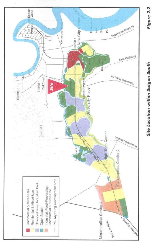
RMIT INTERNATIONAL UNIVERSITY VIETNAM
INITIAL ENVIRONMENTAL EXAMINATION
APPENDICES
Appendix 1 References
Appendix 2 The Project Team
Appendix 3 Advice from People's Committee of HCMC
Appendix 4 Preliminary Environmental Assessment: Meinhardt (Vic) Pty Ltd
Appendix 5 Engineering Evaluation Report: Bonacci Winward (Vic) Pty Ltd
Appendix 6 IEE conducted by VESDEC and VACNE
Appendix 7 Zone Planning Decision
Appendix 8 Photographs
FIGURES
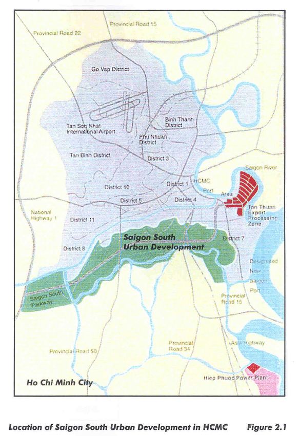
Figure 2.1 Location of Saigon South Development in HCMC
Figure 2.2 Location of the Site within the Saigon South Development
Figure 2.3 RMIT University Stage 1 Development
Figure 2.4 RMIT University Total Development
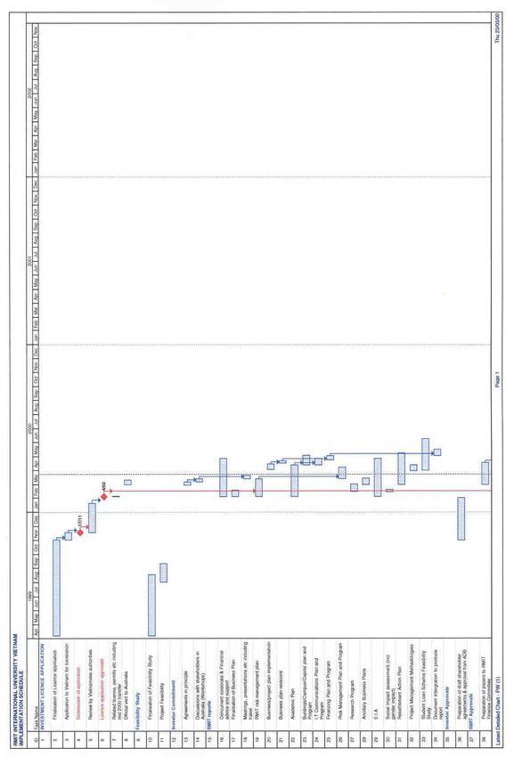
Figure 2.5 Preliminary Project Implementation Schedule
TABLES
Table 3.1 Data on Climate of HCMC
Table 4.1 Impact Matrix
Table 4.2 Financial Evaluation
Table 4.3 Economic Evaluation
Table 4.4 Sensitivity Tests
March 2000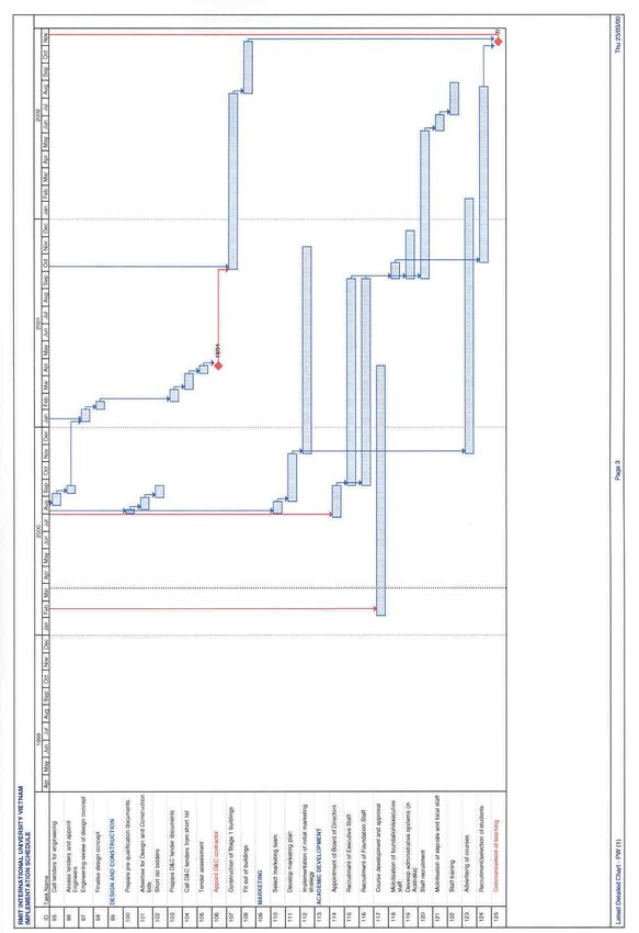
RMIT INTERNATIONAL UNIVERSITY VIETNAM
INITIAL ENVIRONMENTAL EXAMINATION

                                   ABBREVIATIONS

ANZECC       Australian and New Zealand Environment and Conservation Council

BOD          Biological Oxygen Demand

CBD          Central Business District

CFC          Chlorofluorocarbons

COD          Chemical Oxygen Demand

DOSTE        Department of Science, Technology and the Environment

EIRR         Economic Internal Rate of Return

EPA          Environmental Protection Authority

FIRR         Financial Internal Rate of Return

HCMC         Ho Chi Minh City

HPPC         Hiep Phuoc Power Company

IEE          Initial Environmental Examination

MASD         Management Authority South Saigon Development

MOSTE        Ministry of Science, Technology and the Environment

MPI          Ministry of Planning and Investment

NEPL         National Environmental Protection Law

OH&S         Occupational Health and Safety

O&M          Operations and Maintenance

PAP          Project Affected Person

pH           Logarithm of the reciprocal of the hydrogen ion concentration

PHC          Phu My Hung Corporation

PM           Particulate Matter

RAP          Resettlement Action Plan

March 2000
RMIT INTERNATIONAL UNIVERSITY VIETNAM
INITIAL ENVIRONMENTAL EXAMINATION

RL           Reduced Level

RMIT         Royal Melbourne Institute of Technology

SS           Suspended Solids

TAFE         Technical and Further Education

TDS          Total Dissolved Solids

THC          Total Hydrocarbons

TPH          Total Petroleum Hydrocarbons

TPH          Total Petroleum Hydrocarbons

TSC          Trung Son Company Ltd

VESDEC       Vietnamese Association for Conservation of Nature and the Environment

March 2000
RMIT INTERNATIONAL UNIVERSITY VIETNAM
INITIAL ENVIRONMENTAL EXAMINATION

CHAPTER 1
                                    INTRODUCTION

1.1             General

       The RMIT International University is to be established in Ho Chi Minh City (HCMC) on
       a site within the Saigon South Development. An Initial Environmental Examination
       (IEE) is required to determine whether or not significant environmental impacts
       warranting assessment are likely. If a full Environmental Impact Assessment (EIA) is
       not needed, the IEE will be considered as the final environmental assessment.

       This IEE has been prepared in accordance with the Environmental Assessment
       Requirements of the Asian Development Bank 1998.

       The IEE includes:
       • A brief description of the proposed RMIT International University Vietnam;
       • A description of the area affected by the Project;
       • Assessment and prediction of the main potential impacts of the Project on the
          surrounding environment;
       • A description of an Environmental Management Program including measures to
          mitigate impacts and monitoring programs.

1.2             Legal Framework

       The legal framework for environmental management in Vietnam is based on the
       National Environmental Protection Law (NEPL). The Ministry of Science Technology
       and Environment (MOSTE) is responsible for the implementation of NEPL at the
       national level. The Departments of Science, Technology and Environment (DOSTE)
       are responsible at the provincial level.

       The relevant Vietnamese documentation in relation to environmental assessment is:

       •     The National Action Plan for Environment and Sustainable Development,
             prepared by the National Committee for Science, SIDA, UNDP, IUCN, approved
             by the Prime Minister in 1991.
       •     The Law on Environmental Protection approved by the National Assembly of the
             Socialist Republic of Vietnam on 27 December 1993; issued according to the
             order 29-L/CTN 10 January 1994 of the State Chairman.
       •     Decree No 175/CP on 18 October 1994 issued by the Government for the
             guidelines on implementation of the Law on Environmental Protection.
March 2000                                                                                    1
RMIT INTERNATIONAL UNIVERSITY VIETNAM
INITIAL ENVIRONMENTAL EXAMINATION
• Vietnamese Standard of Environment, issued by the Ministry of Science,
Technology and Environment (MOSTE) in 1995.
• Circular No 490/1998/TT-KHCNMT issued on 29th April 1998 by MOSTE5 requiring
content of an EIA study.
The Project will be undertaken within the framework of the Law on Foreign
Investment in Vietnam and under specific regulations as agreed with the Government
of Vietnam for the RMIT International University Vietnam.
The Project has been advised by the HCMC People’s Committee that under MOSTE
guidelines no reporting is required on environmental effects since this is considered
to be an education project. The Committee has also advised that based on Item 2,
Article 39 of the Decree No. 12/CP of 18 February 1997 on implementation of the
Law of Foreign Investment in Vietnam, reporting on environmental effects is not
required. However the investor is required to explain activities which may have
environmental impacts, and to provide solutions and commitment to mitigate impacts
during construction and operation. A translation of this advice is included as
Appendix 3.
1.3 Extent of the Study
Details of references consulted are included in Appendix 1.
The IEE has been prepared by the following team:
Dr Madeleine Reeve: Project Management
Ms Jill Byrne: Project Management
Dr David Petch IEE overview
Dr Robert Noakes: Socio-Economic Impact
Meinhardt (Vic) Pty Ltd: Initial Environmental Assessment
Bonacci Winward (Vic) Pty Ltd: Infrastructure Assessment
Golder Associates: Preliminary Geotechnical Advice.
Details of this Study Team are included in Appendix 2.
The Meinhardt team undertook an initial environmental assessment of the site in
February 1999. This assessment involved:
• Inspection of the site;
• Collection and analyses of soil and water samples;
• Collection of information regarding site history, with emphasis on identification of
possible sources of site contamination or pollution. This research involved a
March 2000 2RMIT INTERNATIONAL UNIVERSITY VIETNAM
INITIAL ENVIRONMENTAL EXAMINATION
review of the literature and discussion with those with knowledge of the site,
including occupants of the site.
The Meinhardt Report is included as Appendix 4.
The Bonacci Winward team visited HCMC in January 1999 to assess infrastructure
requirements as part of RMIT’s Investment Licence application to establish a fully
foreign owned university. Bonacci Winward enlisted the support of Norman Disney &
Young (Services Consulting Engineers) and Golder Associates (Geotechnical
Engineers) to provide specialist expertise in their respective disciplines.
The Bonacci Winward Report is included as Appendix 5.
Dr David Petch who is a specialist in environmental assessment reviewed the IEE.
Dr Robert Noakes, who worked with the ADB as an Evaluation Specialist and
Financial Analyst from 1991 to 1996, undertook the analysis of the socio-economic
impact of the Project.
A Study Team in Vietnam led by Dr Le Trinh, Vice President of the Vietnam
Association for Conservation of Nature and Environment (VESDEC), also prepared
an IEE. During February 2000 the team undertook data collection, field surveys and
analysis. That document is included as Appendix 6 and is referred to as the
VESDEC Report in this document.
March 2000 3RMIT INTERNATIONAL UNIVERSITY VIETNAM
INITIAL ENVIRONMENTAL EXAMINATION
CHAPTER 2 DESCRIPTION OF THE PROJECT
2.1 General
RMIT University proposes to establish and, through a consortium of investors,
operate RMIT International University Vietnam as a university of international
standards, quality assured by RMIT. The objectives of the university are:
• To contribute to human resource development, employment, economic growth
and ecologically sustainable development in Vietnam.
• To assist the skills formation, economic development and poverty alleviation of
Vietnam and surrounding region.
• To strengthen higher education in Vietnam.
• To undertake research, development and innovation in collaboration with
government, private sector, other universities and research centres, both in
Vietnam and internationally.
• To provide teaching and learning programs at international standards through
direct and remote means.
• To encourage community service, technical assistance and interaction with
professional and industry groups.
• To operate the University within the legal and regulatory framework of Vietnam
enabling appropriate returns to investors.
The University will provide a range of preparatory, undergraduate and postgraduate
courses; short courses; English and Vietnamese language courses; study abroad
programs and industry training. Qualifications will include Certificates, Diplomas,
Associate Degrees, Bachelor, Master and Doctoral degrees.
The products and services will include training, consultancies, provision of conference
facilities including hotel, research and development, and technology transfer. They
will also include the provision of staff and student housing; retail outlets for the sale of
educational products such as books and computers; food outlets; clinic; and other
retail, recreational, residential and sporting activities operating as part of the campus
to meet the requirements of students, staff and other clients.
The educational programs will be developed to reflect national needs and market
demand. It is expected that programs will include:
• Undergraduate courses including Bachelor Degrees and possibly, Associate
Degrees and Advanced Diplomas;
• Postgraduate programs by course work and research;
March 2000 4RMIT INTERNATIONAL UNIVERSITY VIETNAM
INITIAL ENVIRONMENTAL EXAMINATION
• Industry training, in-service and on campus;
• Industry innovation and research and development (R&D);
• English learning and Vietnamese language courses;
• Preparatory and Bridging programs;
• Study abroad (inbound and outbound) and transfer.
The University will operate throughout the full year with three 12-week semesters.
Academic year intakes will be in January/February, June and September.
2.2 Category of Project
On the basis of the Asian Development Bank Guidelines this is a Category B Project.
The IFC has determined that it is a Category A Project in terms of its environmental
requirements.
2.3 Need for the Project
The University will be Vietnam’s first truly international campus, contributing to the
development of a large and rapidly growing market in South East Asia in one of the
region’s most dynamic cities, HCMC.
The Project is expected to contribute to providing Vietnam’s workforce with the skills,
competencies and qualifications required in an emerging and vibrant market
economy. Human resources are Vietnam’s primary resource in the modernisation
and industrialisation process by which Vietnam is seeking to improve its standard of
living, redistribute income to the benefit of all the Vietnamese people and develop its
human capital for sustainable development.
The University will also provide Vietnam with a valuable model to assist Vietnamese
educational institutions to develop appropriate flexibility in terms of course content,
duration and methods of delivery.
This Project will provide a powerful combination of training, education and innovative
research and development which will be closely geared to the needs of private
industry, the government and the community. All programs will be delivered with a
unique combination of Vietnamese and international staff, supported by technology
including intensive online support and interactive television instruction.
The University will produce graduates, develop trainees and support technology
clients who will be leaders in the fast changing global community. Benefits to
students and clients include enhancing Vietnam’s economy and growth prospects of
the region.
March 2000 5RMIT INTERNATIONAL UNIVERSITY VIETNAM
INITIAL ENVIRONMENTAL EXAMINATION
2.4 Project location
The 62 hectare site within the Saigon South Development was reserved by the
HCMC People’s Committee for RMIT in March 1999. It is approximately 5 km south
of central HCMC on the Eastern University Park in Development master plan. The
Management Authority for South Saigon Development (MASD) will enter into the land
lease with RMIT.
The location of the South Saigon Development is shown in Figure 2.1. The location
of the site within the Development is shown in Figure 2.2.
The site boundaries are:
• The eastern boundary is adjacent to the planned North-South Highway (District
Road 34);
• The western boundary is adjacent to the Ong Lon Stream;
• The southern boundary is adjacent to the Binh Thuan Road (South Saigon
Parkway);
• The northern boundary is adjacent to the Bang Stream.
The Saigon South Development is Vietnam’s largest urban development project,
stretching some 17.8 km along either side of the new South Saigon Parkway.
Currently two lanes, this road will ultimately be increased to ten lanes, linking the
HCMC Port area with National Highway 1. The Saigon South Development
comprises 2,600 hectares of land along the sides of the Parkway, with green barriers
to the north and south. Phu My Hung Corporation (PMH) is responsible for the
development of the South Saigon Parkway. PMH holds 600 hectares of developable
land. The remaining 2,000 hectares is held by the HCMC Government (via MASD).
2.5 Size of the operation
The campus master plan for Stage 1 is included as Figure 2.3. The master plan for
the total development is included as Figure 2.4.
It is anticipated that in the first year of operation the campus will have a population of
approximately 2000 students, academic and support staff. By Year 10, this
population is estimated to be approximately 9,000.
The master plan has been developed to enhance the existing estuarine environment
of the site. The main nucleus of activity is situated on the central waterfront on the
Ong Lon River. Natural vegetation will be preserved and additional vegetation will
ensure ample natural surroundings. Enhancement will be achieved through the
March 2000 6RMIT INTERNATIONAL UNIVERSITY VIETNAM
INITIAL ENVIRONMENTAL EXAMINATION
construction of a series of connected walkways at an elevation of 1.5 to 2.0 m, and
retention of the internal canal that meanders through the site. The main campus
building and sports hall are located in the western portion of the site. A central
pedestrian spine links the individual faculty buildings which are of a flexible building
type.
An upgraded embankment doubles as a levee to the Ong Lon River, ensuring that the
site is not flooded periodically. The levee has a proposed top level of 2.5m, with a
spillway set at 2.2m to allow water to flow back to the Ong Lon River and prevent
flooding of the site. The size of the spillway will cater for storms of more than 100
year return period.
The proposed fill platform for the campus buildings is a nominal 2.5m which is 0.15m
above the level of the South Saigon Parkway. Building levels would then be at about
2.7m. Current available rainfall data indicate that this should mean that the buildings
should not be subject to flooding.
As part of the approval process for the Zone Planning Certificate, the master plan has
been approved by the HCMC People’s Committee. The Zone Planning Decision (2
August 1999) provides details of the approved land use and proposed infrastructure.
It is included as Appendix 7.
March 2000 7RMIT INTERNATIONAL UNIVERSITY VIETNAM INITIAL ENVIRONMENTAL EXAMINATION March 2000 8
RMIT INTERNATIONAL UNIVERSITY VIETNAM
INITIAL ENVIRONMENTAL EXAMINATION

March 2000                              9
RMIT INTERNATIONAL UNIVERSITY VIETNAM
INITIAL ENVIRONMENTAL EXAMINATION

March 2000                              10
RMIT INTERNATIONAL UNIVERSITY VIETNAM
INITIAL ENVIRONMENTAL EXAMINATION

March 2000                              11
RMIT INTERNATIONAL UNIVERSITY VIETNAM
INITIAL ENVIRONMENTAL EXAMINATION

2.6           Project Implementation

       The preliminary project implementation schedule indicates that site preparation will
       commence in Year 2001 with construction and fit out the first stage of the campus
       facilities to be completed by the end of Year 2002. Incremental development of the
       campus will continue until Year 2012. The preliminary schedule follows as Figure
       2.5.

March 2000                                                                                    12
RMIT INTERNATIONAL UNIVERSITY VIETNAM INITIAL ENVIRONMENTAL EXAMINATION March 2000 13
RMIT INTERNATIONAL UNIVERSITY VIETNAM
INITIAL ENVIRONMENTAL EXAMINATION

March 2000                              14
RMIT INTERNATIONAL UNIVERSITY VIETNAM
INITIAL ENVIRONMENTAL EXAMINATION

March 2000                              15
RMIT INTERNATIONAL UNIVERSITY VIETNAM
INITIAL ENVIRONMENTAL EXAMINATION

CHAPTER 3
                                        DESCRIPTION OF THE ENVIRONMENT

3.1              Physical Resources

3.1.1            Introduction

          The total population of Vietnam is estimated to be about 78 million and population
          growth is currently estimated at about 1.8%. HCMC is Vietnam’s largest city and
          major industrial centre, with a population of approximately 6 million people, most of
          whom live in the eighteen inner urban districts. The city is built on the banks of the
          Saigon River, which is a tributary of the Nha Be River which flows into the South
          China Sea, 50 km south of HCMC. The city is generally flat with much of the
          surrounding rural land used for rice culture.

3.1.2            Climate

          The average annual rainfall is 1,979 millimetres, most of which occurs in the wet
          season from May to November. The average annual temperature is 27 degrees
          Celsius and the average humidity is 80%. Climatic details are provided in the
          following table.

          Table 3.1      Data on climate at HCMC

                  Jan.   Feb.   Mar      Apr.   May    Jun.   July   Aug.   Sept.   Oct.   Nov.   Dec.
Temperature       25.7   26.6    27.8    28.8   28.8   27.4   27.0   27.0   26.7    26.6   26.3   25.7
o
    C
Moisture %         74     71     71       74    80      84     84     85     86      83     82     78

Wind Velocity      2.5    2.8    3.2      3.2   2.7     3.1    3.1    3.3    2.8     2.5    2.3    2.2
M/s
Wind Direction    E      E       SE      SE     E      W      SW     W      W       W      N      N
Radiation Heat    344    401     449     428    351    371    369    365    344     337    325    334
Cal/day
Precipitation      14     4      11       50    219    313    295    269    330     264    114     51
mm/M
Evaporation     124.1 135.6 163.6 146.9 107.9 84.8 84.8 85.7                70.1    68.2   78.3   97.5
mm/M
       Source: DOSTE of Hochiminh City. Data collected from 1981 -1990

March 2000                                                                                               16
RMIT INTERNATIONAL UNIVERSITY VIETNAM
INITIAL ENVIRONMENTAL EXAMINATION
The wind velocity ranges from2.2 to 2.8m/s and the wind direction is dominant East or
South East from January to May, W in June to October, and North in November to
December.
3.1.3 Topography
The site for the proposed campus currently consists of wetlands and reclaimed
agricultural land to the east of the Ong Lon River. Elevation of the site is
approximately +0.8 m. The land is a part of a river delta system, and waterways
through the site are of a tidal nature. At the North of the site, the area has been
reclaimed for agriculture along the Ong Lon River and inland from the River. To the
East of the site there is a small road with a high level of urban development along it.
3.1.4 Soils
The area is alluvial and subject to periodic flooding. The soils are uniform across the
site consisting of a heavy blue-grey cracking clay with a high organic content. As part
of the site assessment by Meinhardt (Appendix 4) the soil profile was tested to a
depth of approximately 2.0 metres. This revealed that the profile was uniform to this
depth, with some red mottling in waterlogged soils.
According to Dr. San Ha from the HCMC University, the area has very deep clay
sediment, with bedrock more than 30 m below the surface level. At points of soil
sampling, a hand auger was used to dig to depths of approximately 500mm. It was
observed that all sample holes were waterlogged at their base.
Most "dry" land across the site is reclaimed land developed by draining and the
excavation or importation of fill material to build paddy levees, pathways and areas
for housing. The area is subject to periodic flooding. The rate of sediment scouring
and deposition during periods of flooding is unknown. Paddy levee banks gradually
sink and are periodically built up, mainly through sods being cut from the floors of
paddies and piled onto the levees. This practice ensures some "recycling" of
sediments, with material being excavated and brought to the surface. This may be
significant in bringing historically contaminated sediment, if it exists, to the surface.
No evidence of pesticide or defoliant contamination was found in any of the soils
sampled.
Many of the randomly selected soil samples were found to have levels of Sulphate
that exceeded ANZECC Environmental Soil Quality Guidelines by very significant
amounts. This sulphate is apparently naturally occurring, and may indicate the
March 2000 17RMIT INTERNATIONAL UNIVERSITY VIETNAM
INITIAL ENVIRONMENTAL EXAMINATION
presence of Acid Sulphate Soils. Such soils are typically waterlogged and anaerobic
and when excavated or otherwise exposed to air can oxidise to produce sulphuric
acid. This can impact on aquatic and marine ecosystems. Such soils need to be
managed to avoid adverse environmental impacts. This can best be achieved by
disposing of excavated soils into aqueous anaerobic environments. Acid Sulphate
Soils are naturally occurring in some water environments and will not have an impact
if deposited back to a similar aqueous environment.
Analysis also revealed that soils across the site were consistently acidic, with pH
levels as low as 3.1. There are no limits for environmental or health investigation
limits recommended for pH. The acid nature of the soil is likely to be caused by the
high levels of organic material and the waterlogged anaerobic conditions of many of
the soils, but may also indicate the presence of oxidising Acid Sulphate Soils. Water
samples taken on the sites were all within the pH range of 6.4 to 7.1, indicating that
the presence of acidic soils and high levels of sulphur were not making the water
unacceptably acidic. The presence of acidic soils may have implications for the
design of concrete building foundations, which will need to be able to withstand or be
protected from corrosion.
Analysis of samples taken from potential “hotspots“ indicated isolated instances of
heavy metal contamination. For example, fill material imported onto the site to build
pathways was found to have high levels of lead, zinc and copper contamination.
River sediment samples were found to be free of significant levels of contamination,
but did have elevated levels of Total Petroleum Hydrocarbons (TPHs), indicating
pollution of waterways by fuels and oils.
Details of the results of the soil analysis are provided in Appendix 4.
3.1.5 Hydrology
The streams in the Project area are part of the Saigon - Dongnai river system. The
waterways through the site are of a tidal nature.
As part of the development of the Saigon South Master Plan, Skidmore, Owings &
Merrill commissioned the engineering firm of Woodward Clyde Consultants (WCC) to
address hydrologic issues. The WCC study indicated that the hydrologic factors
which influence flood and water quality issues in the area are tides, releases from
hydroelectric projects on tributaries to rivers within the area, rainfall-runoff to channels
and waste water discharges. Critical flood events in the Saigon South area are
caused by high tides. The one-percent probability tidal flooding event will result in a
maximum water surface elevation of about 1.6m in the area.
March 2000 18RMIT INTERNATIONAL UNIVERSITY VIETNAM
INITIAL ENVIRONMENTAL EXAMINATION
3.1.6 Ground and surface w ater
The waterways within the South Saigon area are polluted by sewage, nutrients and
litter from local residences and from HCMC. Attempts have been made by the
Vietnamese authorities to reduce the levels of pollution by relocation of residences
away from the waterways, cleaning of the floors of the waterways and appropriate
sewage disposal.
On the campus site, the water table is less than 0.5 m below ground level. Even
during the "dry" (non-monsoon) conditions, water flows through the site and no
instances of stagnant (eutrophied) or odorous water bodies were observed on the site
during the Meinhardt site assessment. Within the site, current pollution of waterways
is most likely to be due to disposal of sewage and other wastes from dwellings.
The tidal range is relatively high but its yearly variation is low. The records at the Phu
An Hydrometeorological Station indicate an average range of 1.7 m to 2.5 m, with a
maximum value of 3.95 m. Seawater intrusion may be significant during the dry
season.
The volume of freshwater flowing down the Saigon River and other major waterways
connecting to waterways on the site is so great that waterways surrounding and on
the site appears to be freshwater rather than brackish or saline. The volumes of
water are also so great that a large dilution factor of pollutants can be expected.
The Ong Lon appears to be less polluted than the Xang Canal, but still appears to be
a degraded waterway, particularly where it is entered by the Xang Canal. The Ong
Lon is a large waterway and pollution from the Xang Canal is diluted as it enters the
Ong Lon River. However, the Ong Lon was observed to be odorous, even at the
southernmost point of the campus site on the River. High levels of litter were also
observed in the river.
Water samples analysed in the study by Meinhardt in February 1999 indicate that the
waterways intersecting and surrounding the site are polluted. Levels of Chemical
Oxygen Demand (COD) and Biological Oxygen Demand (BOD) consistently
exceeded Vietnamese and the Environment Protection Authority Victoria (EPAV)
recommended limits, indicating pollution by nutrients likely to result in eutrophication
of waterways. Total nitrogen levels in water samples were consistently higher than
recommended EPAV limits, creating risk of algal blooms and subsequent
eutrophication of waterways.
March 2000 19RMIT INTERNATIONAL UNIVERSITY VIETNAM
INITIAL ENVIRONMENTAL EXAMINATION
Levels of Total Coliform are consistently high and frequently exceed Vietnamese
Standards for Pollutants in Surface Water Resources (5942-1995). The source of
pollution can be attributed to untreated domestic wastewater (sewage and sullage).
The highest Coliform counts occur on the Xang Canal. The most probable source of
this contamination is discharge of effluent from District Eight. The levels of
contamination may pose health risks to persons exposed to water for contact
recreational purposes. In the event that water from contaminated waterways were
used for spray irrigation, the levels of contamination may pose health risks due to
suspended droplets of water.
The pH levels were found to be within Vietnamese and Victorian EPA surface water
quality limits, indicating that the large volumes of water had buffered any leachate
from acidic soils.
During the first week of February 2000, VESDEC carried out additional survey. In that
mission samples of 5 sampling points had been taken and analyzed. The results are
presented in Table 3.3 in Appendix 6 and confirm the findings of the earlier study
conducted in February 1999 (Appendix 4).
3.1.7 Geology
The subsurface conditions at the site appear to comprise up to 15m of very soft
organic clay, overlying further soft to firm clays, to about RL -21 m. A band of
medium dense sands then extends to about RL –29 m. Underlying this sand are
further interbedded clays and sands generally of firm to stiff consistency for the clays,
and medium dense for the sands. The available borehole data ends at RL-40 m, still
in medium dense to loose sands. The clay soils to RL –21 m are expected to be
highly compressible and of low strength.
3.1.8 Air Quality
HCMC does not yet have the significant air pollution problems of many Asian cities.
However motor vehicles are increasing and air pollution is rising. Serious localised
problems are also becoming apparent as a result of industries such as cement plants,
steel mills and fertiliser plants.
On the basis of the data obtained from the VESDC studies in the dry seasons of
February 2000, and hourly observation in the area site, air quality in the project area
can be assessed as good (refer Table 3.4, Appendix 6). Concentrations of SO2, NO2,
total hydrocarbon (THC), H2S are still much lower than that of the maximum allowable
levels of the Vietnamese Ambient Air Quality Standards (TCVN 5937-1995).
March 2000 20RMIT INTERNATIONAL UNIVERSITY VIETNAM
INITIAL ENVIRONMENTAL EXAMINATION
However, concentration of particulate matter (PM) is higher than ambient air standard
(TCVN 5937-1995) due to transport activities.
All the observed data indicate that noise level at site is not too high (60 - 85 dBA at
rush hour). However, it exceeds noise requirements in the Vietnamese Standard for
sensitive area as resident area (lower than 70 dBA).
3.2 Ecological Resources
3.2.1 Flora
The survey undertaken by VESDEC in February 2000 indicated that there are two
dominant ecosystems within the project area. Inland fauna was not identified
Lowlands Influenced by Tide
Along the Tu Dinh Watercourse, Cyperus malaccensis (Lac nuoc) is frequently
dominant. In addition, the survey team identified other species such as: Sacciolepis
myosuroides (Mom mo), Nypa fruticans (Dua nuoc), Acrostichum aureum (Rang dai).
In the higher regions, available shrub vegetation consists: Glochidion littorale (Tram
bau), Sonneratia caseolaris (Ban chua), Annona glabra (Binh bat), Cryptocoryne
ciliata (Mai dam), Derris trifolia (Coc ken), Acanthus ebracteatus (O ro). Some hygric
species are present in the higher wet regions as Eclipta prostrata (Co muc), Panicum
repens (Co ong), Mimosa pigra (Trinh nu nhon), Passiflora foetida (Nhan long), and
Ipomoea aquatica (Rau muong).
Land along the Roads
Road construction has resulted in recent changes to the composition of soils. The
Poaceae (Hoa ban) family is dominant. Eleusine indica (Man trau), Echinochloa
stagtina (Gai thao muong), Eragrostis tremula (Xuan thao), Pennisetum polystachyon
(Co duoi voi), Chloris barbata (Luc long), Cynodon dactylon (Co chi), Dactyloctenium
aegyptiacum (Co chan ga), Hedyotis heyni (Lu dong), Emilia sonchifolia (Chua le),
Polanisia chelidonii (Mang mang tim), Mimosa pudica (Trinh nu) were all identified
within the area.
In general, the number of plant species in the study area is not abundant (29
species), and includes many common species. The site is covered by fresh water
vegetation. A list of inland species identified is included in Table 3.5 in Appendix 3.
March 2000 21RMIT INTERNATIONAL UNIVERSITY VIETNAM
INITIAL ENVIRONMENTAL EXAMINATION
3.2.2 Aquatic Organisms
The results of VESDC’s survey in February 2000 are presented in detail in Appendix
6 (Tables 3.3 to 3.11). Following is a summary of these results.
The aquatic organisms can be grouped as:
• Zooplankton : 24 species
• Zoobenthos : 13 species
• Phytoplankton: 111 species
Species groups in low brackish water environment are:
• Zooplankton: Oithona similis, Limnoithona sinensis, Mesopodopsis slabberi,
Polychaeta larva.
• Zoobenthos: including 7 species of Polychaeta, Tachaea chinensis (Isopoda –
Crustacea), Angulus vestalis (Mollusca – Bivalvia).
• Phytoplankton: including 8 species of Coscinodiscus genera, Leptocylindrus
danieus, Chaetoceros compactum, Biddulphia levis, Ditylum sol, Gyrosigma
balticum.
Species groups in low acid water are:
• Zooplankton: Lecane (Monostyla) bulla, Brachionus quadridentatus (Rotatoria),
Paracyclops fimbriatus, Ectocyclops phaleratus (Copepoda).
• Zoobenthos: It is not pronounced. May be Limnodrilus hoffmeisteri, Branchiura
sowerbyi (Oligochaeta) have distributed widely in fresh water and indicated for
low acid water kind.
• Phytoplankton: Phormidium tenue, Eunotia didyma, Eunotia elegans,
Ankistrodesmus falcatus, Closteriopsis longissima, Scenedesmus acuminatus,
Scenedesmus javaensis, Closterium gracile, Closterium macilentum.
The typical species composition in rich organic matter and polluted environment is:
• Zooplankton: Philodina roseola, Rotaria neptunia, Rotaria rotaria, Brachionus
angularis, Brachionus calyciflorus, Brachionus quadridentatus, Moina dubia,
Mesocyclops leuckarti, Oithona similis, Pristina longiseta.
• Zoobenthos: Limnodrilus hoffmeisteri, Branchiura sowerbyi, Bispira polymorpha,
Potamilla leptochaeta, Melanoides tuberculatus, Nephthys polybranchia,
Namalycastis longicirris, Lycastis indica, Neanthes caudata (Polychaeta).
March 2000 22RMIT INTERNATIONAL UNIVERSITY VIETNAM
INITIAL ENVIRONMENTAL EXAMINATION
• Phytoplankton: mainly species of Cyanophyta, Euglenophyta and Bacillariophyta:
Melosira granulata, Cyclotella meneghiniana, Coscinodiscus subtilis, Chaetoceros
compactum, Synedra ulna.
At the beginning of the dry season, fresh water species dominate in Zooplankton
(19/24 species) and migratory species of a marine origindominate in Zoobenthos
(9/13 species).
Details of the numbers of aquatic organisms are presented in Table 3.12 Appendix 6.
In summary:
• Zooplankton: 2,350 to 18,200 individuals/m3. In most areas, fresh water species
are dominant such as: Philodina roseola, Brachionus urceus, Mesocyclops
leuckarti vaø Nauplius larva. Occasionally marine species such as Schmackeria
bulbosa and Nauplius larva dominate.
• Zoobenthos: 570 to 9420 indivduals/m2. Species of Limnodrilus hoffmeisteri,
Branchiura sowerbyi dominate in some areas. In other areas, Polychaeta
dominate.
• Phytoplankton: 70,250,000 to 177,750.000 cell/m..
• In most areas, the dominant species is Cycltella meneghiniana. Occasionally,
Nitzschia longissima var. reserva is dominant. Both have migrated from marine
areas and adapted conditions of low saline and contamination in this area.
In general, the diversity index of aquatic organisms in the project area is low. Details
are presented in Table 3.13, Appendix 6. In summary:
• Phytoplankton: 0.005 to 0.007.
• Zooplankton: 0.059 to 0.186.
• Zoobenthos: 0.054 to 0.377.
Water pollution has decreased the diversity of aquatic fauna and flora. However,
wastewater impact differs between sampling points.
Details of the distribution of aquatic organisms are presented in Table 3.14, Appendix
6. In summary, in the canals within the project area, only Phytoplankton has the
same distribution over the site. There is variation in the distribution of Zoobenthos
and Zooplankton over the site.
March 2000 23RMIT INTERNATIONAL UNIVERSITY VIETNAM
INITIAL ENVIRONMENTAL EXAMINATION
3.3 Human and Economic Development
3.3.1 Human Development
Education and training is an area of identified priority for the Government of Vietnam.
As part of the process of reform, modernisation and integration with the international
community, Vietnam is keen to access formal training from developed countries such
as Australia. However the numbers of private students who can afford to study
overseas is low compared with other Asian countries.
Vietnam has a population of 78 million, of whom 18 million live in urban areas. This
figure is predicted to grow to 100 million by the year 2010 and 112 million by 2030.
Trends suggest that 20% of the population is between the ages of 15 and 24 and that
the number of students enrolling in secondary education is about half of the relevant
age group population. This ratio is expected to increase with the improvement in
Vietnam's economic situation.
Vietnam has almost universal primary school enrollment and has established a
comprehensive network of educational institutions throughout the country, including a
primary education facility in every commune. In 1995 the adult literacy rate was 91%
for women and 96% for men. Compared with other countries with similar income
levels, these percentages mark great achievements in education. However access to
education is marked by substantial inequities with public spending on education
biased towards the non poor.
One of the major challenges for Vietnam is to ensure that the system of education
and training responds to the emerging demands of a growing market economy.
Expansion and modernisation of the education and training system are important
elements of the Government’s strategy to sustain rapid economic growth and
alleviate poverty. There has been a rapid increase in tertiary or higher education
enrolments with an annual average rate of increase of 11.1% between 1985 and
1995. The Government target is for a 65% increase in enrolments between 1994 and
2004. A number of strategies will be required to achieve this, including user fees and
private sector development as well as increased public spending. The rate of return to
family investments in tertiary education is high and students who attend colleges and
universities should be expected to share significantly in the burden of costs of their
education. This should help the Government to meet its medium to long term targets
and reduce what must be recovered from the State budget. By encouraging private
alternatives for families with financial resources, the Government subsidies already
going to education will redistribute themselves automatically in favour of poorer
families.
March 2000 24RMIT INTERNATIONAL UNIVERSITY VIETNAM
INITIAL ENVIRONMENTAL EXAMINATION
The Joint Report of the Government-Donor-NGO Working Group (December 1999),
Attacking Poverty, indicates considerable progress in reducing poverty between 1993
and 1998. The report indicates:
• Improvement is represented quantitatively by rising per capita expenditures and
improving social indicators including: enrollment in primary and secondary
education; child and adult nutrition; access to infrastructure; and ownership of
consumer durables.
• Poverty is largely a rural phenomenon with 45% of the rural population living
below the poverty line.
• Pockets of severe poverty exist in urban areas.
• The South East region, including HCMC, is the wealthiest region by a
considerable margin.
The Joint Report concludes that Vietnam’s high economic growth rate from 1993 to
1998 underlies the success in reducing poverty. This growth was based largely on
land-based agricultural diversification which may be limited in the future. The report
also points out that the rate has fallen to around 4% in the crisis years of 1998 and
1999 and that greater reliance for growth will need to be placed on rural off-farm
employment and urban employment.
The development of opportunities for employment and productivity growth are linked
to providing Vietnam’s workforce with appropriate skills, competencies and
qualifications required for an emerging economy. Hanoi and HCMC are the focal
points for Vietnam’s industrial and commercial activities and the development of new
technology based industries. They account for approximately 50% of the nation’s
GDP (HCMC 35% and Hanoi 15%). Skills in demand in these major centres cover
information technology, marketing, logistics, distribution, manufacturing automation,
education and education management, business administration, financial
management, international trade, property management, human resource
management and environmental management.
3.3.2 Current Infrastructure and Development Status
As part of the Feasibility Study undertaken for the project, the consulting engineering
firm of Bonacci Winward undertook a study of the current infrastructure and the
infrastructure needs of the project. The report on infrastructure is included as
Appendix 5.
There has been no construction work to date on land held by the MASD. PMH has
undertaken substantial landfilling operations for construction of the Saigon South
Parkway, raising ground level from approximately RL 0.5 m to RL 2.35 m, some 850
March 2000 25RMIT INTERNATIONAL UNIVERSITY VIETNAM
INITIAL ENVIRONMENTAL EXAMINATION
mm above the maximum high tide recorded (over a 50 year period), of RL 1.50 m.
Landfill is ongoing for the PMH development sites. Sand is dredged from the Saigon
River, barged and trucked to site, and placed with minimal (if any) compaction.
Various buildings and facilities have already been constructed on PMH land, and
others are under construction.
PMH is responsible to supply the infrastructure requirements of the 600 hectares of
developable land which they hold. As a private supplier, they may extend their supply
of services to other developments within Saigon South, including to those on MASD
land.
Electricity Supply
Power is currently available via PMH’s Power Station at Hiep Phuoc, approximately
20 km to the south. It supplies the new City Centre area (east end of the Parkway),
and is being reticulated (aerially), to other PMH sites. Presently there is no
reticulated electricity supply to the site. The nearest available supply exists
approximately 2km east on the southern side of Saigon South Parkway at PMH’s
Substation A2. This substation is supplied by diesel generator sets (size unknown
but estimated at 1.5MVA maximum) and transformed to high voltage for reticulation to
existing installations at the eastern end of Saigon South Parkway.
Water Supply
Water is currently being reticulated (generally underground), to PMH sites from the
secondary treatment plant at Tan Thuan. Water originates from the Government
Water Supply at Thu Duc, some 15 km north of HCMC. Water is not available at the
RMIT site at present.
Communications
PMH is progressively bringing communication services to Saigon South, but not as
far as the RMIT frontage at present. Clarification has been sought from PMH as to
the standard of service to be provided.
Sewage Treatment
There is no trunking or treatment plant available at present, though it is part of the
long term plan for Saigon South.
Stormwater System
Stormwater presently discharges directly to the canal/river system.
March 2000 26RMIT INTERNATIONAL UNIVERSITY VIETNAM
INITIAL ENVIRONMENTAL EXAMINATION
3.3.3 Land Use
Land-use on the site consists of areas of uncultivated marshland and rice cultivation
on reclaimed agricultural land on the rest of the site. Several clusters of dwellings
exist on the site. In addition to rice cultivation, many of the dwellings have deeper
ponds into which sewage and organic household waste are deposited. These ponds
are used for the cultivation of fish, ducks, molluscs and water vegetables.
Much of the land facing the Saigon South Parkway consists of marshland that is not
used extensively by local farmers. It appears that some uncultivated water
vegetables are harvested from the area. Traffic on the site is restricted mainly to
pedestrian traffic. In some areas where waterways are sufficiently deep and wide,
boat traffic also occurs.
A Compensation Strategy was prepared as part of the Feasibility Study for the Project
in August 1999. The Strategy detailed the following land use on the Project site:
• Farming land and ponds: 52.31 ha
• Dwellings: 0.95 ha
• Ditches: 7.31 ha
• Gardens and hill: 2.0 ha.
Housing and Properties
The Compensation Strategy indicates that 134 households will be affected and are
subject to resettlement. There are 152 persons residing on the site and 216
unemployed farm labourers.
The compensation for affected people is detailed in:
• The Decision No. 5352/QD-UB-QLDT dated 21 July 1995 by HCMC People's
committee regarding the Regulations for compensation to move inhabitants in the
area of zone planning of the South Saigon New Urban in districts of 7, 8, Binh
Chanh, Nha Be;
• The Decree No. 22/1998/ND-CP dated 22 April 1998 by the Government and
Memo No. 22/1998/U-B-KT dated 3 January 1998 by HCMC People's Committee
regarding the guidelines for other basic construction expenses.
March 2000 27RMIT INTERNATIONAL UNIVERSITY VIETNAM
INITIAL ENVIRONMENTAL EXAMINATION
3.4 Quality of life values
3.4.1 Socio-Economic Values
Education and training is an area of identified priority and high demand from the
Government of Vietnam. As part of the process of reform, modernisation and
integration with the international community, Vietnam is keen to access formal
training from developed countries such as Australia. However the numbers of private
students who can afford to study overseas is low compared with other Asian
countries.
3.4.2 Gender
There have been some changes in attitudes to women in Vietnam and major
achievements in setting up a legal framework to ensure women’s rights and equal
status in society. However women suffer a range of disadvantages, particularly in
rural areas and among ethnic minorities. In general, women’s educational attainment
is lower than men’s and they are poorly represented in decision-making positions in
the workforce. The rate of women obtaining tertiary and higher education degrees
(1.1%) is half that of men (2.1%).
3.4.3 Archaelogical /Historical Treasures
The site currently contains 97 concrete graves and 688 soft graves. Relocation of
these graves forms part of the Resettlement Action Plan.
March 2000 28RMIT INTERNATIONAL UNIVERSITY VIETNAM
INITIAL ENVIRONMENTAL EXAMINATION
CHAPTER 4 SCREENING OF POTENTIAL
ENVIRONMENTAL IMPACTS AND
MITIGATION MEASURES
4.1 General
A matrix summarising impacts from both the construction and operational phases of
the Project is included as Table 4.1 which follows.
Table 4.1 Impact Matrix
IMPACT MITIGATION MEASURES
PROJECT LOCATION
Resettlement of current Adequate compensation to allow for
occupants and loss of land relocation, purchase of suitable land to allow
resumption of agriculture and aquaculture
and construction of houses. Counselling and
training of people as appropriate.
Relocation of graves Adequate funds made available to ensure
proper transportation and relocation of
graves.
Loss of wetlands Design allows significant areas to be
retained. Use of timber walkways.
CONSTRUCTION PHASE
Earthworks interfering with Contractor to construct temporary drainage
hydrology to ensure drainage of surrounding areas is
not disrupted.
Contractor to ensure proper disposal of spoil
and to minimise changes to the landscape.
Increased traffic Temporary access roads to be constructed
by the Contractor.
March 2000 29RMIT INTERNATIONAL UNIVERSITY VIETNAM
INITIAL ENVIRONMENTAL EXAMINATION
Increased dust, gas emissions Use of dust control agents eg water.
and vibration
Paving of heavy use areas.
Appropriate location of equipment and
vehicles away from residential areas.
Proper maintenance of vehicles and
equipment.
Acidification due to exposure Minimisation of disturbance of acid sulphate
of acid sulphate soils. soils. Burial, neutralisation and separation
of the soils.
Risks to safety of workers Implementation of OH&S Plan.
Provision of medical facilities on site.
Increased noise levels Implementation of Noise Management Plan
ensuring noise limitation to daylight hours
and installation of noise barriers and mufflers
on vehicles as required.
OPERATION
Increased traffic Implementation of Transportation Plan
including details of the internal traffic system,
off street parking, loading and service
access.
Inappropriate effluent Treatment plant involving nutrient removal
discharge causing health and odour control measures. Additional
problems and algal growth in filtration using sand filters if necessary.
canals.
Flooding of the site and Stormwater collected and directed to the
surrounding areas. wetlands via underground pipes or covered
channels. Peak runoff reduced by restricted
capacity of culverts. Levees will allow some
detention of runoff in the canals.
Pollution of waterways and Careful design of internal waterways to
disturbance of hydrology of minimise impacts. Construction of bund and
the area. valve controlled outlet to allow drainage of
canals for maintenance. Construction of
March 2000 30You can also read