Developing impact-based thresholds for coastal inundation from tide gauge observations
←
→
Page content transcription
If your browser does not render page correctly, please read the page content below
CSIRO PUBLISHING

Journal of Southern Hemisphere Earth Systems Science, 2019, 69, 252–272
https://doi.org/10.1071/ES19024

     Developing impact-based thresholds for coastal inundation
     from tide gauge observations

     Ben S. Hague A,B,C, Bradley F. Murphy A, David A. Jones A and Andy J. Taylor A
     A
      Bureau of Meteorology, GPO Box 1289, Melbourne, Vic. 3001, Australia.
     B
      School of Earth, Atmosphere and Environment, Monash University, Clayton, Vic., Australia.
     C
      Corresponding author. Email: ben.hague@bom.gov.au

     Abstract. This study presents the first assessment of the observed frequency of the impacts of high sea levels at locations
     along Australia’s northern coastline. We used a new methodology to systematically define impact-based thresholds for
     coastal tide gauges, utilising reports of coastal inundation from diverse sources. This method permitted a holistic
     consideration of impact-producing relative sea-level extremes without attributing physical causes. Impact-based thresh-
     olds may also provide a basis for the development of meaningful coastal flood warnings, forecasts and monitoring in the
     future. These services will become increasingly important as sea-level rise continues.The frequency of high sea-level
     events leading to coastal flooding increased at all 21 locations where impact-based thresholds were defined. Although we
     did not undertake a formal attribution, this increase was consistent with the well-documented rise in global sea levels.
     Notably, tide gauges from the south coast of Queensland showed that frequent coastal inundation was already occurring.
     At Brisbane and the Sunshine Coast, impact-based thresholds were being exceeded on average 21.6 and 24.3 h per year
     respectively. In the case of Brisbane, the number of hours of inundation annually has increased fourfold since 1977.

     Received 3 December 2018, accepted 14 October 2019, published online 11 June 2020

1 Introduction and motivation                                          and CES (2018) found similar results for tide gauges in Victoria.
As the earth warms under the enhanced greenhouse effect, global        However, such increases can only be translated into direct
sea levels have risen significantly due to the thermal expansion of    physical impacts if the relationship between the thresholds used
sea water and the melting of land ice (Church et al. 2013; IPCC        and the water levels that cause inundation on land is known.
2014). In the Australian region, both tide gauges and regional             Church et al. (2006) attempted a national assessment of
satellite data show a significant rise which is broadly in line with   changes in the frequency of extreme sea-level events over the
the global trend (Bureau of Meteorology 2019; McInnes et al.           1920–2000 period but deemed tide gauge records to be of
2016; McInnes et al. 2015; Couriel et al. 2014; White et al. 2014;     insufficient length at all but two (southern Australian) locations.
Watson 2011; You et al. 2009; Church et al. 2006).                     With tide data now extending over more than 30 years at many
    Substantial future sea-level rise can be expected as a result of   sites, we see value in re-examining the question of whether
past and future greenhouse gas emissions (IPCC 2014). Many             extreme sea level frequencies are changing, and if this is associ-
studies have projected increases in mean and extreme sea levels        ated with increasing impacts. WMO (2011) states that 30 years of
for Australia in the future (e.g. Wahl et al. 2017; McInnes et al.     climatological data is enough to capture climatological variability
2016; CSIRO and Bureau of Meteorology 2015; McInnes et al.             of physical parameter, and this period is greater than the 18.6-year
2003a, 2009, 2013; Morris et al. 2013), and these are the basis        nodal cycle which is the most significant source of low-frequency
for a range of planning and adaptation responses being put in          variability of astronomical tides (Haigh et al. 2011).
place. Devlin et al. (2017) also note that changes in tidal range          We have chosen to restrict the scope of this initial study to
may amplify or mitigate against changes in mean sea levels.            Northern Australia, though the approach is generic. It is notable
Although future impacts are dependent on assumptions about             that Queensland was assessed by the DCCEE (2011) as having
social and economic changes in the coastal zone and future             the largest asset value threatened by climate change–related sea-
adaptation and emission pathways, it is evident that these             level rise. Future work is planned to apply the method described
impacts will be significant (Reisinger et al. 2014).                   herein to other locations across Australia, and potentially to the
    In contrast to the large body of research focusing on future       broader Pacific region.
changes, few studies have investigated changes in the frequency            The physical drivers of coastal sea levels cross a complex
of extreme sea-level events due to the already-observed changes        range of spatial and temporal scales (McInnes et al. 2016).
in mean sea level. Eliot (2012) and Pattiaratchi and Eliot (2008)      Academic studies have understandably focused on understand-
found a significant increase in the frequency of exceedances of        ing these and attributing effects to these drivers. In the Australia-
vertical thresholds at gauges in south-west Western Australia,         Pacific region, storm surges (e.g. Callaghan and Helman 2008),

Journal compilation Ó BoM 2019 Open Access CC BY-NC-ND                                                     www.publish.csiro.au/journals/es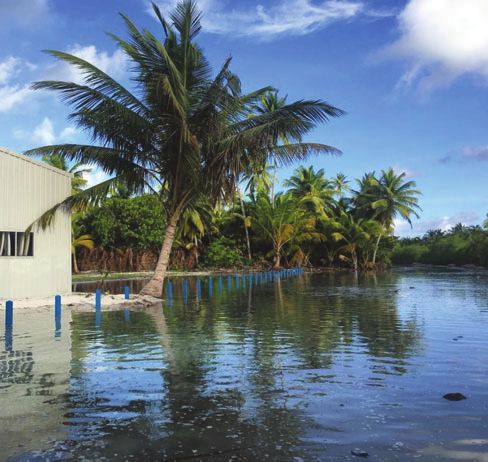
Impact-based thresholds for coastal inundation                              Journal of Southern Hemisphere Earth Systems Science      253

wave run-up and set-up (e.g. Hoeke et al. 2013), infra-gravity         directly related to sea level (e.g. as described by McInnes et al.
waves (e.g. Hoeke et al. 2013; Damlamian et al. 2015), coastally       2016) but sometimes can be due to estuarine, fluvial and pluvial
trapped waves (e.g. Maddox 2018a, 2018b), astronomical tides           flooding interacting with higher ocean levels at coastal margins
(e.g. Hanslow et al. 2018; Ford et al. 2018), tsunami (e.g. Beccari    (e.g. Wu et al. 2018; Moftakhari et al. 2017, 2018; Callaghan
2009; Fritz et al. 2011), meteotsunami (e.g. Pattiaratchi and          and Power 2014). Impact-based thresholds allow localisation
Wijeratne 2015) and climatic variability (e.g. Widlansky et al.        and personalisation of climate risks which can raise local
2013) all have been associated with impact-producing extreme           awareness (Velautham et al. 2019). They also assist policy-
sea-level events. The analysis we apply here more closely              makers to develop relevant policies for their jurisdictions
follows conventional climate analysis where changes in statistics      (CSIRO and Bureau of Meteorology 2015) with reference to
are explored without attempting to diagnose the drivers.               past impacts within residents’ memories. This work has the
    In addition to defining inundation thresholds and allowing an      potential to provide guidance for possible coastal impacts when
analysis of the changing frequency at which these thresholds are       coupled with Australian storm surge (e.g. Greenslade et al.
exceeded, the information we provide here is valuable for              2018; Allen et al. 2018) or total water-level models (e.g. Taylor
informing impact-based forecasting, warning and monitoring             and Brassington 2017). It is worth noting that extremely low sea
services. Forecasts and warnings that provide reference to poten-      levels can also produce impacts (e.g. Bureau of Meteorology
tial impacts are essential for population safety and asset protec-     2011; Widlansky et al. 2013); however, this study focuses on
tion; however, these cannot be developed without the knowledge         defining impact-based thresholds for extreme high sea levels
of historical impacts to inform forecasting and warning criteria       only, due to the well-documented likely increases of these
(WMO 2015). Impact-based thresholds for climate analysis and           events as a result of climate change.
hydrometeorological forecasting are commonly used in Austra-               Most studies in the Australia-Pacific region have hitherto
lia, for example in agriculture (e.g. Asseng et al. 2011), extreme     utilised annual recurrence intervals (ARIs) or annual exceedance
heat (e.g. Nairn and Fawcett 2013), riverine flooding forecasting      probabilities (AEPs) to define extreme sea-level events
and warnings (Bureau of Meteorology 2013) and tsunami warn-            (Stephens et al. 2016, 2018; Pattiaratchi et al. 2018; Stephens
ings (Allen and Greenslade 2008). The Bureau of Meteorology            2015; Haigh et al. 2012, 2014a, 2014b; McInnes et al. 2003b,
(2013) defines the lowest flood threshold (minor) as correspond-       2013; Church et al. 2006). By construction, ARIs and AEPs focus
ing with impacts such as inundation of areas near watercourses,        primarily on events that occur infrequently (e.g. once every 10
including pedestrian and bicycle paths, as well as the closure of      years) which may or may not be associated with impacts.
roads and low-level bridges. However, there are very few tidal         However, studies and reports from Australia (Attard et al.
waterways with these flood thresholds defined. Given these             2019; Witness King Tides 2019; Hanslow et al. 2018; Maddox
impacts are like those that occur during coastal inundation events     2018a; Zheng 2017; Jacobs 2012, 2014, 2015, 2016; Green Cross
(e.g. Witness King Tides 2019; Green Cross Australia 2012;             Australia 2012; DERM 2011; DECCW 2009; Watson and Frazer
DERM 2011), the definition of impact-based thresholds in the           2009) and overseas (Hino et al. 2019; Roman-Rivera and Ellis
coastal zone complements the existing riverine and estuarine           2018; Jacobs et al. 2018; Rojas et al. 2018; Haigh et al. 2017;
thresholds. This is also consistent with international coastal flood   Sweet et al. 2016; Ray and Foster 2016; Selvaraj 2016; Ezer and
classifications (e.g. Ghanbari et al. 2019).                           Atkinson 2014; Sweet et al. 2014) have documented infrastruc-
    Outside of Australia, a few studies have used impact-based         ture, economic, environmental and social impacts associated with
thresholds to study coastal inundation. Ford et al. (2018) defined     high sea levels occurring at near-annual, annual or subannual
impact-based thresholds by collating impact reports and finding        frequencies, mostly due to high astronomical tides.
corresponding tide gauge levels at one gauge in the Marshall               Some studies have used tidal parameters derived from
Islands, and Sweet et al. (2018) defined thresholds for inunda-        harmonic analysis to define extreme sea levels (e.g. Hanslow
tion on a continental scale. However, Sweet et al. (2018) relied       et al. 2018; CES 2018; Stephens 2015; Stephens et al. 2014;
on an assumption of intercomparability of sites rather than            Morris et al. 2013; Bureau of Meteorology 2011). As these
sourcing impact reports at every location where thresholds are         metrics are typically exceeded on an annual or subannual basis,
defined. Furthermore, the sites used as the basis for this             they are better placed to provide useful insights on impacts and
comparison typically had flood thresholds defined using a              projections for tidal-driven coastal inundation. However, an
harmonic parameter, mean higher high water (NOAA 2018),                important additional consideration is the vulnerability of land
which is defined without reference to water levels that may            and infrastructure to these extreme sea levels. These metrics
cause inundation on land. Haigh et al. (2017) collated the             cannot consider the effect that local variations in planning policy
impacts of historical coastal flooding events in the UK and            may have on differences in vulnerability. For example, through
assessed events on an impact-based scale but did not define            the spatial variability of the heights of vertically offset assets
tide level thresholds associated with these impacts. Thus, our         (houses, roads, ports, etc.) above typical high-tide levels (Brown
study is the first to apply a consistent methodology to define         et al. 2018; Kirkpatrick 2012).
impact-based thresholds at multiple tide gauges using actual               This study addresses several key gaps in existing knowledge
impact reports along large stretches of coastline.                     of Australian extreme sea levels. It pulls together contemporary
    Another benefit of impact-based thresholds lies in their           reports of coastal inundation with quality tidal observations to
ability to easily account for compound events where impacts            develop thresholds at which inundation impacts are felt. These
can occur from the combining effects of multiple, often minor,         thresholds are then used to develop time series of inundation,
factors (Leonard et al. 2014). Sometimes these factors are all         including an analysis of emergent trends. Finally, the framework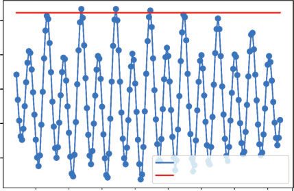
254      Journal of Southern Hemisphere Earth Systems Science                                                                           B. S. Hague et al.

Table 1. Northern Australian tide gauges with data used in this study, with gauge name, Australian National Tide Tables (ANTT) Port Number
             (as per e.g. Australian Hydrographic Service 2017) and start and end of data period that satisfies criteria in Section 2.1
Percentage completeness and total number of data-years (i.e. the length of record excluding any missing data) provide information on data quality. Latitude
                                                    and longitude provide geographic information

Gauge name                ANTT #         Start date        End date          Completeness (%)         Data-years        Latitude (8S)       Longitude (8E)

Booby Island               58 230        1/01/1987         31/12/2017               90.3                  28                10.6                141.91
Bowen                      59 320        19/11/1986        31/12/2017               98.4                  30.6              20.02               148.25
Brisbane                   59 980        1/01/1977         31/12/2017               91.4                  37.5              27.37               153.17
Bundaberg                  59 820        16/02/1966        31/12/2017               96.8                  50.2              24.77               152.38
Cairns                     59 060        1/01/1982         31/12/2017               91                    32.8              16.92               145.78
Cape Ferguson              59 260        1/01/1982         31/12/2017               90.7                  32.7              19.28               147.06
Carnarvon                  62 370        1/01/1987         31/12/2017               91                    28.2              24.9                113.65
Cocos Islands              46 280        11/12/1985        31/12/2017               96.5                  30.9              12.12                96.89
Darwin                     63 230        31/12/1958        31/12/2017               92.9                  54.9              12.47               130.85
Gladstone                  59 750        5/01/1978         31/12/2017               95.6                  38.3              23.83               151.25
Hay Point                  59 511        1/01/1982         31/12/2017               90.3                  32.5              21.28               149.3
Ince Point                 58 140        1/01/1988         31/12/2017               91.1                  27.4              10.51               142.31
Karumba                    63 580        1/01/1985         31/12/2017               93.4                  30.8              17.5                140.83
Lucinda                    59 200        6/06/1985         19/12/2017               98.1                  31.9              18.52               146.38
Mackay                     59 510        1/01/1984         31/12/2017               91.9                  31.3              21.1                149.23
Mooloolaba                 59 950        1/01/1984         31/12/2017               90.4                  30.8              26.68               153.13
Mourilyan Harbour          59 140        26/12/1984        31/12/2017               98.3                  32.5              17.6                146.12
Onslow                     62 470        7/07/1985         31/12/2017               99                    32.2              21.65               115.13
Port Alma                  59 690        31/12/1985        31/12/2017               99.3                  31.8              23.58               150.87
Port Hedland               62 590        1/01/1966         31/12/2017               90.9                  47.3              20.32               118.57
Shute Harbour              59 410        1/01/1986         31/12/2017               91.5                  29.3              20.28               148.78
Townsville                 59 250        4/01/1959         31/12/2017               98.7                  58.3              19.25               146.83
Urangan                    59 850        25/09/1986        31/12/2017               95.3                  29.8              25.3                152.92
Weipa                      63 620        1/01/1982         31/12/2017               92.1                  33.2              12.67               141.87

we develop provides the basis for the future forecasting, warning               present a pragmatic challenge to homogenising long records and
and monitoring of coastal inundation events in real-time, like                  our approach is detailed below. Making precise survey connec-
what is already undertaken for variables such as rainfall and                   tions between impact-based threshold values derived from tide
temperature.                                                                    gauge observations and common datums would represent a
                                                                                valuable extension but is beyond the current scope.
2 Data and methodology                                                              The hourly resolution of the data limits the study’s ability to
2.1 Data sources and processing                                                 consider contributions to extreme sea levels that occur on
The Bureau of Meteorology maintains a national repository of                    timescales of less than 1 h. The hourly values are typically
hourly resolved relative sea-level observations from tide gau-                  produced by resampling and filtering higher frequency data.
ges. These gauges are typically located on coastal infrastructure               This means they are more representative of an average sea level
like jetties and are operated by the Bureau, port authorities and               over an hour than an instantaneous value.
other agencies. Much of this data has been added to other                           Although impact-based thresholds can be defined for a gauge
repositories such as the Global Extreme Sea Level Analysis                      record of any length, provided impacts are reported during the
(GESLA)-2 project (Woodworth et al. 2017, http://gesla.org/,                    period of data availability, WMO (2011) recommends 30 years
accessed 20 April 2020), the University of Hawaii Sea Level                     of homogeneous data with 80% data completeness for climato-
Center (UHSLC) database (Caldwell et al. 2015, https://uhslc.                   logical information. Given the homogeneity of Australia’s tide
soest.hawaii.edu/data/, accessed 20 April 2020) and the                         gauge records has not been assessed in the same way as other
Bureau’s Australian Baseline Sea Level Monitoring Project                       climatic variables, for example temperature (Trewin 2013, 2018),
(ABSLMP) database (http://www.bom.gov.au/oceanography/                          the completeness criterion is tightened to 90%. This helps account
projects/abslmp/data/index.shtml, accessed 20 April 2020).                      for the fact that long periods of missing data potentially indicate a
Hourly values are produced on an annual basis, with data up to                  replacement of equipment or site move, both of which may result
the end of 2017 available for use in this study.                                in an inhomogeneity (Trewin 2013). As Table 1 shows, only tide
   This data set contains only relative sea level, which is of                  gauge records with at least 27 data-years (i.e. 30 years with 90%
primary concern for coastal inundation. Connections to survey                   completeness), and 90% completeness over the entire data period
reference elevations such as Australian Height Datum (AHD) or                   are used. In some cases, this has required records to be shortened
geodetic ellipsoidal heights are important for many applications                (but not to less than 27 data-years) to meet these criteria. Figure 1
but are not treated directly here. Overt shifts in tide gauge datums            shows the geographical locations of these gauges.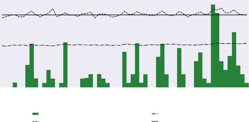
Impact-based thresholds for coastal inundation                                        Journal of Southern Hemisphere Earth Systems Science   255

                                                         Locations of tide gauges - WA and NT

                                       Cocos Islands (Home Island)
                                                                                                             Darwin

                                                                     Port Hedland
                                                                     Onslow

                                                                Carnarvon

                                                         Locations of tide gauges - Queensland

                                            Ince Point
                                Booby Island

                                      Weipa

                                  Karumba                  Cairns
                                                             Mourilyan Harbour

                                   Townsville            Lucinda
                                                   Cape Ferguson
                                                                        Bowen
                                                Shute Harbour
                                                                             Mackay
                                                                Hay Point

                                                                                       Port Alma
                                                                       Gladstone
                                                                                        Bundaberg
                                                                                                   Urangan

                                                                                            Mooloolaba
                                                                                            Brisbane

                      Fig. 1. Location of tide gauges used in this study from northern Western Australia and the Northern
                      Territory (upper) and Queensland (lower).

   White et al. (2014) assessed the suitability of Australian tide               undetected datum shifts at the Gold Coast, that suggests further
gauge records for monthly trend and variability analysis. They                   investigation as part of a homogenisation procedure is required.
found anomalous trends at Wyndham and King Bay, and                              For the purpose of this analysis, these locations are excluded.
256                                  Journal of Southern Hemisphere Earth Systems Science                                                              B. S. Hague et al.

                                              Brisbane January 2013 sea-level event
                                                                                                    information to determine the exact timing of the inundation.
                                                                                                    Daily or event maximum values are used to bias the method
                               2.5
 Tide gauge observations (m)

                                                                                                    against defining an impact-based threshold too low; this means
                                                                                                    the thresholds defined herein are equivalently a little high.
                               2.0
                                                                                                    Figure 2 demonstrates the difference between event and daily
                                                                                                    maximum values and how these can be used to develop impact-
                               1.5                                                                  based thresholds. In this example, the event maximum is the
                                                                                                    highest observation above the red impact-based threshold line. If
                               1.0                                                                  the daily maximum on the 15th was to have also been above the
                                                                                                    red line, this would trigger a new event, whereas a higher value
                               0.5                                                                  on the 14th would be part of the event beginning on the 11th. If
                                                                           Hourly sea level
                                                                           Impact-based threshold
                                                                                                    the 11th, 12th and 13th were the only days where impacts were
                                                                                                    reported in the observational record and impact reports were
                                          10    11     12     13     14       15     16     17      clearly dated and timed, then the maximum hourly observation
                                        January
                                         2013                                                       on the 13th would be the impact-based threshold as this is the
                                                            Date (local)                            lowest of the three daily maximum values. If the reports were not
                                                                                                    clearly dated (e.g. a news report from the 15th mentioned
Fig. 2. Hourly sea-level time series for Brisbane, 9–17 January 2013 (local                         inundation in the previous week), the event maximum would
time). Daily maxima are 2.66 m (11th), 2.66 m (12th) and 2.64 m (13th).                             be used for the impact-based threshold.
                                                                                                        Typically, two processes were used to match impacts with sea-
                                                                                                    level observations. The first (‘impact first’) involves identifying
2.2 The definition of impact-based thresholds, exceedances                                          an impact and then searching for a candidate extreme sea-level
and events                                                                                          event. The second (‘event first’) involves generating a list of
Impact-based thresholds are defined as the lowest hourly sea                                        candidate events from the hourly maximum sea-level observa-
level for which coastal inundation impacts are reported at a                                        tions and then searching for impacts associated with those times.
location. This is achieved by collating multiple reports of coastal                                 These two processes operate ad infinitum, producing increasingly
inundation impacts and matching the times of these impacts to                                       accurate estimates of the impact-based threshold as more evi-
sea levels recorded at a proximate tide gauge, typically within                                     dence is uncovered, or future impact-producing sea-level events
20–50 km. The lowest of these sea levels is then designated as                                      occur. Candidate events in the ‘event first’ method were usually
the impact-based threshold for that tide gauge location.                                            generated as any observed exceedance of the highest astronomi-
    An implication of this definition is that it is possible that                                   cal tide (HAT), which is the conventional definition of extreme
inundation does not always occur when the impact-based thresh-                                      sea level used by the Bureau of Meteorology (2011). By con-
old is exceeded. This could be for many reasons, such as higher                                     struction, ‘impact first’ will predominate if the impact-based
frequency sea-level variability such as waves not detected by a                                     threshold is below HAT, whereas ‘event first’ will dominate if the
tide gauge, or that there are small differences between the sea                                     impact-based threshold is above HAT. In either case, the more
level at the tide gauge and where impacts are observed. In                                          coastal inundation events that are reported, the less influence
determining impact-based thresholds, we have ignored reports                                        HAT has on the final impact-based threshold. If no impacts were
of impacts on open coasts where waves are more prevalent.                                           documented, no impact-based threshold has been defined. If there
    Frequency of inundation is measured using two different                                         was evidence to suggest impacts occurred on an annual or
metrics, exceedances and events. An ‘exceedance’ is a single                                        multiyear basis but no specifics on exactly when it occurred,
instance of the hourly sea level being higher than the defined                                      HAT was designated the impact-based threshold.
impact-based threshold. An ‘event’ is a period of at least one
exceedance. An event starts at the time of the first exceedance and                                 2.3 Finding reports of coastal inundation
ends at the time of the last exceedance, assuming there are no                                      Given the scarcity of impact-based threshold and impact reports
subsequent exceedances within the following 48 h. This period of                                    for coastal inundation in Australia within the scientific literature;
48 h ensures that the hourly sampling of the data captures the                                      this study relies heavily on pictorial, dated and eyewitness evi-
highest high tides of each diurnal cycle, which is on average 24 h                                  dence of extreme sea-level impacts. The three most frequently
and 50 min, and that prolonged events lasting multiple days are                                     cited sources are Queensland Government-sponsored pictorial
captured. Related concepts can also be defined, such as ‘annual                                     surveys conducted in 2012 (Green Cross Australia 2012) and
event frequency’, the annual number of extreme sea-level events,                                    2011 (DERM 2011), and the Flickr account of Witness King
and ‘annual average exceedances per event’, which is the quotient                                   Tides (2019). Other sources of information include recent online
of the annual total number of exceedances and the event fre-                                        news and social media (e.g. Twitter, Facebook and Instagram)
quency. These concepts help determine the relative contributions                                    searches after and during coastal inundation events. Correspon-
of changes in the frequency and duration of events.                                                 dence with the Bureau of Meteorology staff in Queensland,
    In most cases the sea-level values associated with inundation                                   Northern Territory, Western Australia and Cocos Islands offices
that are used to define the impact-based thresholds are the                                         also provided evidence of extreme sea-level impacts that were not
highest daily hourly sea levels; however, sometimes event                                           previously documented in the scientific literature or media. These
maximum hourly values are used if there is not enough                                               expert anecdotal sources were especially useful for more isolated
Impact-based thresholds for coastal inundation Journal of Southern Hemisphere Earth Systems Science 257
Table 2. Sea levels associated with highest astronomical tide (HAT) and impact-based threshold (IBT) in metres
Annual averages and decadal trends in the number of annual exceedances (of IBT), annual events and the average number of exceedances per event.
Underlined values denote statistical significance (P , 0.05)
Exceedance Events Exceedance per event
Gauge name ANTT # HAT IBT Ann. ave Decadal trend Ave Decadal trend Ave Decadal trend
Booby Island 58 230 4.3 4.20 21.44 11.24 4.65 0.58 5.42 1.62
Bowen 59 320 3.7 3.67 2.74 0.08 0.7 0.00 2.03 0.18
Brisbane 59 980 2.7 2.61 21.55 10.82 6.68 1.91 3.77 0.32
Bundaberg 59 820 3.7 3.46 10.51 2.47 3.09 0.82 3.22 0.25
Cairns 59 060 3.5 3.36 4.55 1.57 1.45 0.52 2 0.36
Cape Ferguson 59 260 3.8 3.51 13.16 3.86 3.88 0.68 3.96 0.19
Carnarvon 62 370 2.1 –
Cocos Islands 46 280 1.6 1.6 48.33 35.97 5.65 3.02 8.14 2.14
Darwin 63 230 8.1 7.89 2.03 0.84 1.19 0.52 1 0.35
Gladstone 59 750 4.8 4.58 9.52 3.23 3.38 1.27 2.74 0.11
Hay Point 59 511 7.1 6.81 6.92 2.56 2.76 0.85 2.11 0.17
Ince Point 58 140 3.8 3.66 2.59 0.78 0.62 0.2 1.95 0.05
Karumba 63 580 4.9 4.66 3.21 1.61 0.66 0.19 2.11 0.59
Lucinda 59 200 4.0 3.76 9.81 3.13 2.77 0.92 3.19 0.32
Mackay 59 510 6.6 6.35 3.71 1.53 1.81 0.86 1.72 0.14
Mooloolaba 59 950 2.2 2.06 24.27 7.12 6.14 0.86 4.19 0.35
Mourilyan Harbour 59 140 3.5 3.49 1.04 0.35 0.38 0.15 0.91 0.22
Onslow 62 470 3.1 –
Port Alma 59 690 6.0 –
Port Hedland 62 590 7.6 7.76 0.06 0.03 0.05 0.02 0.08 0.02
Shute Harbour 59 410 4.3 4.25 3.2 0.75 1.38 0.49 1.73 0.12
Townsville 59 250 4.1 3.99 3.39 0.98 1.28 0.20 1.81 0.30
Urangan 59 850 4.3 4.12 6.96 2.01 3.15 0.75 1.99 0.30
Weipa 63 620 3.4 3.57 1.77 1.3 0.42 0.23 1.65 1.09
areas. Confirmation bias is potentially an issue, as reports of completeness. If years have less than 70% completeness,
nonevents or near misses are rare, and it is impossible to deter- they are not used for the purposes of statistical analysis of
mine whether this is because they did not occur or because they trends in exceedances.
were not reported, or both. Sparsely populated areas are likely Event analysis has added complexity due to the decomposition
more susceptible to this bias than large towns and cities. of events into their frequency and the number of exceedances per
event. Therefore, the implicit independence assumption used by
2.4 Missing data considerations WMO (2017) in defining the adjusted exceedance count may not
Further to the commentary on data completeness in Section 2.1, hold. Hence, no adjustments to event counts were made and a
additional considerations are required to mitigate against the minimum data completeness of 95% was imposed for years to be
effects that missing data may have. WMO (2017) provides some included in the analysis of trends.
guidance as to the handling of missing data for count parameters
such as the number of exceedances of a threshold per year. The
3 Results and discussion
advice is that counts should be calculated using ratios of avail-
able data in the averaging period rather than the length of 3.1 Impact-based thresholds for northern Australia
averaging period. Based on this advice an adjusted exceedance Table 2 lists the impact-based thresholds defined at the 24
count is used. In practice, this means that if a year has 10% locations in northern Australia considered in this study, using
missing data and has 9 occasions where the designated threshold the methodology described in Sections 2.2 and 2.3. Two
has been exceeded throughout the remainder of the year (i.e. the examples of how the impact-based thresholds were derived
90% where data is not missing), then the adjusted exceedance are given below for two major population centres in northern
count is 10. The adjusted exceedance count is used subsequently Australia with long tide gauge records: Brisbane and Towns-
in this analysis and referred to simply as ‘exceedance’. ville. For the sake of brevity, information on the determination
Second, in addition to the 80% overall criterion, upgraded of impact-based thresholds at the other 22 locations is
to 90% as discussed in Section 2.1, WMO (2017) states that for presented in Appendix 1. Table 2 also presents the HAT value
a count parameter to be calculated in a given time period, at (Australian Hydrographic Service 2017), and trends in
least 70% of the data must be available. Therefore, the adjust- exceedances, events, and average number of exceedances per
ment procedure is only applied to years with at least 70% event, as defined in Section 2.2.258 Journal of Southern Hemisphere Earth Systems Science B. S. Hague et al.
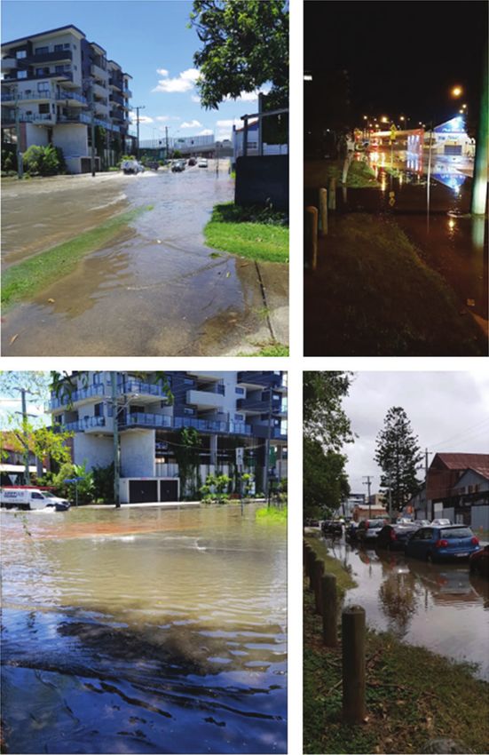
Fig. 3. Inundation in the Brisbane suburb of Windsor, located on the tidal Enoggera Creek, on 2 January
2018 (top and lower left), 12 July 2018 (top right) and 21 February 2019 (lower right). All images by Harry
Clark, reproduced with permission.
3.2 Determining the Brisbane impact-based threshold these days of inundation respectively (Caldwell et al. 2015;
Coastal inundation occurs regularly in Brisbane, typically http://uhslc.soest.hawaii.edu/data/?fd). Witness King Tides
associated with high astronomical tides. Figure 3 provides (2019) documents four inundation events between 2012 and
images of inundation on 2 January 2018, 12 July 2018 and 2014, with inundation occurring on 7 separate days (Table 3).
21 February 2019. Provisional (UHSLC Fast Delivery) hourly The lowest of these daily maxima is 2.61 m. Note that as the
maximum values of 2.85, 2.91 and 2.74 m are associated with impacts are clearly dated the daily maximum sea levels can beImpact-based thresholds for coastal inundation Journal of Southern Hemisphere Earth Systems Science 259
Table 3. Impact reports from Witness King Tides (2019) Flickr page Townsville and at nearby Magnetic Island (Fernbach et al. 2014;
for Brisbane area Denison 2014; Dunn et al. 2014). Sea levels on that day reached
4.34 m at Townsville and 3.99 m at Cape Ferguson. Inundation
Date Sea Locations affected of coastal infrastructure also on Magnetic Island occurred on
level (m) 31 January 2010 (Witness King Tides 2019). GHD (2012), in a
21/01/2012 2.61 Hawthorne, Newstead report commissioned by Townsville City Council, note that
22/01/2012 2.68 Breakfast Creek, Lota, Nudgee, Shorncliffe, damage due to storm surges and king tides occurred in 1971 due
Wynnum to TC Althea (event maximum of 4.42 m at Townsville), in 2009
23/01/2012 2.73 Brisbane CBD, East Brisbane, Kangaroo Point, during Cyclone Charlotte (4.38 m at Townsville and 4.04 m at
Hawthorne, Hendra, Lota, Manly, New Farm, Cape Ferguson) and in 2011 during Severe Tropical Cyclone
Nudgee, Sandgate, Shorncliffe, South Brisbane, Yasi (4.46 m at Townsville and 4.00 m at Cape Ferguson).
Wynnum, West End Systems Engineering Australia (2009) noted that Cyclone
05/06/2012 2.76 Wynnum Charlotte damaged coastal protections and infrastructure at
12/01/2013 2.66 Breakfast Creek, Hendra, Lota, Manly, Milton, several locations in Townsville, including very close to the tide
New Farm, Nudgee, Sandgate, Wynnum
gauge. Yasi also caused inundation in Townsville (Bureau of
13/01/2013 2.64 Lota
02/01/2014 2.78 Lota, New Farm Meteorology 2018b) where an extreme sea-level event occurred
due to a large surge despite the astronomical tide at the time
being 70 cm lower than HAT, with observations of 4.34 m at
Townsville and 4.0 m at Cape Ferguson.
used, rather than event maximum, even though many of the days Inundation has also occurred without the influence of tropi-
with impacts are from the same event. Figure 2 shows that the cal cyclones, with Green Cross Australia (2012) reporting
equal-highest observation of the period was on 11 January 2013; inundation on 22 January 2012 in the Railway Estate. This
however, this does not appear in Table 3, as no impact reports coincided with a 3.99-m sea-level observation at the Townsville
could be found for this day. This does not necessarily mean that gauge and 3.60 m at Cape Ferguson. Witness King Tides (2019)
impacts did not occur, merely that if they did, they were not also report inundation on 12 January 2013 (Townsville: 4.01 m
reported. Even if they did not occur, this is not incongruous with and Cape Ferguson: 3.64 m) and 2 January 2014 (Townsville: no
the impact-based threshold definition as that merely states that it data and Cape Ferguson: 3.51 m). The 2014 event has the lowest
is the lowest sea level at which inundation is reported. maximum hourly sea-level value at Cape Ferguson so the
DERM (2011) reported inundation at numerous locations impact-based threshold there is 3.51 m. However, the lack of
in the wider Brisbane area (Cleveland Point, Lota, Luggage data at Townsville on this day (unfortunately in outage during
Point, Albion, Nudgee, Sandgate, Shorncliffe, Scarborough and this period) means that the impact-based threshold there is
Deception Bay) on the morning of 21 January 2011 (local time). defined using the 21 January 2012 exceedance value of 3.99 m.
The highest hourly sea-level recorded at around this time at the
Brisbane tide gauge was 2.74 m at 0100 UTC (i.e. 11 a.m. local 3.4 Trends in exceedances and events
time) on the 21st. Green Cross Australia (2012) reported All locations studied have experienced increases in the fre-
inundation at numerous locations on the morning of 22 January quency of exceedance of impact-based thresholds, where one
2012 (local time) (Lota and Cleveland) and 23 January could be defined (Table 2). This means that coastal inundation is
2012 (Cleveland, Brisbane CBD, Hawthorne, East Brisbane, becoming more common along the coastline of northern
Sandgate and New Farm). The daily highest hourly sea levels Australia. Trends were calculated using a simple linear fit to the
associated with these coastal inundations were 2.68 and 2.73 m annual number of exceedances and events, for years with at least
respectively. Williams (2015) reported inundation at Sandgate 70% data completeness. Trends in the exceedance of impact-
on 20 January 2015, when sea levels reached 2.79 m. Flooding based thresholds are statistically significant (P , 0.05) at 11 out
also occurred 2 days later in Newstead and Albion (Orr 2015) at of 21 locations. At Brisbane 21.6 h of inundation has occurred,
a 2.82 m sea level. Based on these observations, the impact- on average, per year since 1977. The time series of the number of
based threshold is defined as 2.61 m, the lowest daily value, hourly observations above the impact-based threshold per year,
which occurred on 21 January 2012 with impacts reported at along with annual maximum and mean sea levels, are shown in
Hawthorne and Newstead (Table 3). Fig. 4. The occurrence of coastal inundation has increased at a
rate of 10.8 h per decade, corresponding to a doubling every
3.3 Determining the Townsville impact-based threshold 20 years (Table 2). These rapid increases reveal the seemingly
Like Brisbane, coastal inundation is now a regular occurrence in disproportionate response in the frequency of coastal inundation
Townsville, with many reports of inundation around the city to a relatively modest increase in mean sea level.
over the last decade. There are two tide gauges within the Townsville has had fewer exceedances of its impact-based
vicinity of Townsville, one at Townsville and another at Cape threshold than Brisbane, averaging 3.4 h of coastal inundation
Ferguson. Due to their proximity, the same inundation events per year, with these exceedances increasing at a rate of 1.0 h per
are used to define impact-based thresholds at both gauges. decade (Table 2, Fig. 5). This represents a doubling in frequency
A storm surge and king tide associated with ex-Tropical approximately every 34 years. The Sunshine Coast has experi-
Cyclone Dylan (Bureau of Meteorology 2018a) on 30 January enced the same doubling in frequency; however, the trends at the
2014 produced widespread flooding of roads and properties in Sunshine Coast represent a much greater increase in terms of the260 Journal of Southern Hemisphere Earth Systems Science B. S. Hague et al.
Coastal inundation frequency (by year):
Brisbane (1977–2017)
70 4
Hours of coastal inundation per year
60
3
Sea-level height (m)
50
2
40
30 1
20
0
10
0 –1
77 80 83 86 89 92 95 98 01 04 07 10 13 16
19 19 19 19 19 19 19 19 20 20 20 20 20 20
Year
Number of exceedances of impact-based threshold Mean annual sea level (m)
Maximum annual sea level (m) Impact-based threshold (m)
Fig. 4. The number of hourly observations above the impact-based threshold (exceedances) has increased in Brisbane over the period of
1977–2017. The sea-level threshold and annual maximum and mean sea levels are also shown. Values of mean, maximum and exceedance
count only shown for years where data completeness exceeds 70%.
Coastal inundation frequency (by year):
Townsville (1959–2017)
20.0 5
Hours of coastal inundation per year
17.5
4
15.0
Sea-level height (m)
3
12.5
10.0 2
7.5
1
5.0
0
2.5
0 –1
59 6 4 69 74 79 84 8 9 9 4 9 9 04 09 14
19 19 19 19 19 19 19 19 19 20 20 20
Year
Number of exceedances of impact-based threshold Mean annual sea level (m)
Maximum annual sea level (m) Impact-based threshold (m)
Fig. 5. The number of hourly observations above the impact-based threshold (exceedances) has increased in Townsville over the period of
1959–2017. The sea-level threshold, and annual maximum and mean sea levels are also shown. Values of mean, maximum and exceedance
count only shown for years where data completeness exceeds 70%.
number of events. There is a long-term average of 24.3 hourly Townsville (average is 12.8 events per decade) (Table 2). The
observations above the impact-based threshold per year and an trends in the average number of exceedances per event are less
increase in 7.1 observations of inundation per decade (Table 2). clear, with a mix of increases and decreases and only three
The frequency of extreme sea-level events has increased at statistically significant results across the 21 locations where
all locations, with trends statistically significant at many loca- impact-based thresholds were defined (Table 2). This suggests
tions, including Brisbane and Townsville. The number of that, in general, the increase in total time that coastal inundation
impact-producing extreme sea-level events has increased by is experienced (i.e. exceedances) is due to there being more
1.9 events per decade (overall average is 6.7 events per year) at frequently occurring inundation events, rather being due to
Brisbane and by one event approximately every 31 years at coastal inundation events lasting for longer. This is typical ofImpact-based thresholds for coastal inundation Journal of Southern Hemisphere Earth Systems Science 261
impact-based thresholds will enable increasingly accurate esti-
mates of the susceptibility of a location to coastal inundation.
Second, regarding Torres Strait; Booby Island exceeds the
impact-based threshold on average 21 h per year, whereas at
Ince Point, the impact-based threshold is exceeded for 2.56 h per
year. This suggests that a more detailed investigation of coastal
inundation in the Torres Strait is warranted and that the relation-
ship between sea levels and inundation events at Ince Point,
Booby Island and Thursday Island (where the impacts were
reported – refer Appendix 1) is complex. The differences could
be due many factors including, but not limited to, the three
locations being mutually nonrepresentative, differences in surge
time or a datum issue. Persistent oceanic, climatological or
meteorological conditions (e.g. the prevailing wind directions
during surges relative to the gauges) could also be important.
Hence, a more localised assessment of coastal inundation is
warranted, especially given the potentially very high vulnera-
bility of these communities (Mackie 2010; Green et al. 2009;
DCC 2009; TSRA 2008). A possible longer term solution to this
problem is combining the record from a newly installed
ABSLMP gauge on Thursday Island (data since 2015) and
Fig. 6. Extreme sea levels inundate roads, foreshore reserve and infra- historical data from other gauges. This could be done as part
structure at West Island, Cocos Islands on 4 December 2017. Photo: Alana- of a future homogenisation effort (refer Section 4.1).
Jayne Moore, reproduced with permission.
Third, as stated in the Appendix 1, there have been very few
dated impact reports on Cocos Island, and it is likely that a
the increase in tidal inundation, which reduces the difference HAT threshold is too low. However, it is known that inundation
between inundation thresholds and heights of typical high tides occurs more frequently and on lower sea-level observations than
until most high tides surpass these thresholds completely the lowest event maximum for which impacts were reported
(Ghanbari et al. 2019; Sweet et al. 2014, 2018; Dahl et al. 2017). (4 December 2017, Fig. 6). Hence as per Section 2.2, the level
corresponding to HAT is defined as the impact-based threshold.
3.5 Spatial variability of coastal inundation frequency
Given the impact-based threshold is a proxy for the level at 3.6 Attribution of coastal inundation events to climate
which coastal inundation impacts occur, the frequency at which change
the impact-based threshold is exceeded is a measure of a loca- This study has not formally considered attribution of the
tion’s susceptibility to inundation. Of course, this measure of increases in extreme sea levels. However, our analysis indi-
susceptibility does not speak to social or economic impacts, but cates that increases in very high extreme sea levels have been
rather simply the occurrence of impacts at some thresholds. accompanied by a decrease in low extreme sea levels, sug-
Thus, we can note that (by a large margin) the locations most gesting that the change in mean sea level is at least partially
susceptible to coastal inundation in northern Australia are responsible for the trends. We examined the frequency at
Brisbane, the Sunshine Coast (Mooloolaba), the Torres Strait which sea levels below tide gauge zero were recorded. The
(Booby Island, see caveat below) and Cocos Islands (see caveat Australian Hydrographic Service (2017) considers this value to
below) (Table 2). The susceptibility of the Torres Strait to be the definition of the lowest astronomical tide (Jayaswal
inundation has been well-noted previously (Mackie 2010; Green pers. comm.). Hence, is it comparable to the analysis con-
et al. 2009; DCC 2009; TSRA 2008), but little literature exists ducted on the exceedance of the HAT, except looking at
for the relative susceptibility of the other locations. extremely low sea levels. Of the 18 gauges in this study where
There are three key caveats to these conclusions. negative tide heights were recorded, all except two recorded
First, as reports of impacts are required to define impact- decreases in the frequency of such values.
based thresholds, the results are potentially biased towards more These results are congruent with a hypothesis of an increase in
populated locations where there are more media outlets and mean sea level contributing to the increase in extreme sea-level
higher social media usage. This results in higher documentation events. A similar concept was applied to extreme land tempera-
of impacts, and hence more impacts on which to define an tures to describe the differences expected from changes in the
impact-based threshold. This does not mean that large popula- mean, variance and both mean and variance in IPCC (2012). This
tion centres such as Brisbane and Mooloolaba have their could be a target area for future work, especially as tidal inunda-
susceptibility overestimated, rather all other locations probably tion gains more of the public’s attention and motivates a need for
have their susceptibility underestimated. In other words, it is quantifying the extent to which anthropogenic climate change
likely inundation occurs more often than it is reported in less- contributed to extreme sea-level events, as has been the case with
populated areas. As further historical impacts are uncovered, extreme temperatures in Australia (e.g. Lewis and Karoly 2013;
or more coastal inundation events occur, the revision of Black and Karoly 2016; Hope et al. 2016).262 Journal of Southern Hemisphere Earth Systems Science B. S. Hague et al.
4 Future work minimum sea level at which impacts may typically occur. Future
4.1 Developing a high-quality homogenised sea-level data observations of impacts will allow further refinement of the
set impact-based thresholds. A future study defining impact-based
thresholds in Southern Australia would further the analysis of
The Bureau of Meteorology has several carefully curated and
coastal inundation frequency along the Australian coastline.
homogenised terrestrial climate data sets covering land temper-
Development of extreme sea-level forecasting and warning
ature (Trewin 2013), rainfall, humidity, cloud cover and evapo-
services on many timescales will become increasingly important
ration which are used for systematic reporting of Australia’s
in the future, as mean sea level, and the changes in frequency of
climate variability and change, as well as providing the basis
extreme sea levels it elicits, will increase regardless of emission
for the biannual State of the Climate Reports (e.g. Bureau of
pathways (Church et al. 2013). Ghanbari et al. (2019) found that
Meteorology and CSIRO 2018). The collation of the data used in
under a scenario of 60 cm of sea-level rise many locations in the
this study represents a first step in extending these methodologies
United States would experience coastal flooding multiple times
to past and real-time sea-level data to arrive at a future homo-
per week, and in some cases, daily. Given existing capability for
genised Australian sea-level data set. Further analysis, especially
modelling total water level at or near the coast (Greenslade et al.
regarding past and future extreme sea levels, would greatly
2018; Allen et al. 2018; Taylor and Brassington 2017), the
benefit from homogenous sea-level data, like that of ACORN-
thresholds defined herein could easily be incorporated into
SAT (Trewin 2013). Although some metadata is available,
the forecast and warning processes these models enable. For
including some geodetic levelling data for the ABSLMP sites
example, Taylor and Brassington (2017) use HAT as an alert
(Geosciences Australia 2018; Bureau of Meteorology 2011),
threshold; this could easily be changed to the impact-based
statistical techniques like those used by Trewin (2013) may allow
threshold to make this product’s alert level closer to the sea
for the development of a long relative sea-level record for sites
levels with which inundation is associated.
where information on relative positions of historical benchmarks
The effects of climate variability and drivers such as El Nino
are limited. These techniques will also allow data from many
Southern Oscillation, Indian Ocean Dipole and Madden-Julian
sources to be integrated to provide a nationally consistent tide
Oscillation on sea level is well known (Pugh and Woodworth
gauge data set with greater spatial and temporal resolution
2014). How these are responsible for modulating the frequency
than pre-existing networks. Alignment of the data sets with
of inundation events in Australia warrants further examination.
contemporary spatial data frameworks will be essential to ensure
Quantification of these relationships for Australian coastlines
that the values reflect user community requirements across the
could support the development of a seasonal outlook for coastal
planning, water and emergency response sectors. References
inundation risk, like that of National Ocean Service (2018), or be
such as AHD and GNSS offsets are notably absent from the data
applied to the modelling of Widlansky et al. (2017).
set used for this study, but more generally we suggest an ongoing
coordination with the Foundation Spatial Data Framework of
ANZLIC. 4.3 Impact-based thresholds as annual recurrence intervals
and annual exceedance probabilities
4.2 A national database of sea-level impacts and impact- It was demonstrated in Table 2 that inundation occurs more fre-
based thresholds to produce an impact-based forecasting quently than the return periods often used to define extreme sea
and warning system levels in many locations. However, this does not mean that ARIs
A potential limitation of this methodology is that the sea-level cannot be considered for future applications of this work. If one so
observations are point based, but the impact observations are desired, ARIs for each location could be defined based on the
from numerous locations, without accounting for complex average annual exceedance of the impact-based thresholds in
coastal effects that potentially vary susceptibility to impacts Table 2. The return periods would be different for each location,
from location to location. This suggests that the ability to due to the different susceptibilities to coastal inundation at each
downscale (i.e. define an impact-based threshold where there is location. This would allow projections of future coastal inunda-
not a tide gauge) and upscale (i.e. use an impact-based threshold tion to be made within the existing framework (e.g. as used by
for a single tide gauge for a regional warning service) is a Wahl et al. 2017 and McInnes et al. 2013).
potential limitation of this methodology. However, this analysis
has demonstrated that broadscale events with similar regional
impacts (e.g. the very high tides of 20–21 January 2011) have 5 Conclusion
reached or exceeded impact-based thresholds at most locations. This study has defined impact-based thresholds at multiple
This suggests that impact-based thresholds are representative of locations in northern Australia and determined the frequency of
broader regions and are consistent from region to region, despite coastal inundation events. Impact-based thresholds are defined
not explicitly considering locally varying coastal processes. by matching the occurrence of coastal inundation to relative sea
Allen and Greenslade (2008) drew similar conclusions while levels at proximate tide gauges and are agnostic to the cause of
developing exceedance thresholds for a tsunami warning ser- exceedances of those thresholds. We find that sea levels that
vice, finding that maximum offshore tsunami amplitude was a produce coastal inundation occur multiple times per year in most
suitable proxy for coastal impacts, despite not taking complex major coastal towns and cities in northern Australia.
coastal effects into account. Nevertheless, the impact-based We find that the frequency at which sea levels associated
thresholds herein represent the current best estimate of a with coastal inundation are being reached has increased overImpact-based thresholds for coastal inundation Journal of Southern Hemisphere Earth Systems Science 263
the past 30–50 years in northern Australia at all locations cyclone-dylan-makes-landfall-in-north-queensland/5229340 [Verified
studied, with just over half of the results statistically signifi- 21 June 2018].
cant (P , 0.05). Increasing trends in the number of events Allen, S. C. R., and Greenslade, D. J. M. (2008). Developing tsunami
(a period when extreme sea levels exceed the impact-based warnings from numerical model output. Nat Hazards 46, 35–52. doi:10.
threshold at least once every 48 h) are also observed at all 1007/S11069-007-9180-8
Allen, S., Greenslade, D., Colberg, F., Freeman, J., and Shultz, E. (2018). A
locations. The frequency of occurrence of coastal inundation
first-generation national storm surge forecast system. In: ‘Bureau
has been doubling every 20 years in Brisbane since 1977 Research Report No. 28’. (Bureau of Meteorology Australia.)
and every 34 years in Townsville since 1959. This detection of Asseng, S., Foster, I., and Turner, N. C. (2011). The impact of temperature
an increasing frequency of coastal inundation at a time that variability on wheat yields. Global Change Biol. 17, 997–1012. doi:10.
mean sea level is rising is a first for such a large region of 1111/J.1365-2486.2010.02262.X
Australia. Attard, A., Brander, R., and FitzGerald, T. (2019). ‘New South Wales
There are several clear points where this work could be Community Perceptions of Coastal Erosion and Inundation’, 137 pp.
further improved, and the authors plan to explore some of these (University of New South Wales: Sydney, NSW, Australia.) Available at
in subsequent analyses. The data used here are not homogenous https://www.bees.unsw.edu.au/nsw-my-coast-study [Verified 20 April
insofar as they have not been subjected to a comprehensive 2020].
Australian Hydrographic Service (2017). ‘Australian National Tides Tables
homogenisation process like that used to produce the ACORN-
2018 (AusTides 2018 Software)’. (Department of Defence, Common-
SAT data set (Trewin 2013). We hope that the definition of wealth of Australia.)
impact-based thresholds and the analysis presented here will Beccari, B. (2009). ‘Measurements and Impacts of the Chilean Tsunami of
motivate further research on coastal inundation events, espe- May 1960 in New South Wales, Australia’, 42 pp. (NSW State Emer-
cially in the attribution and future projections space. This work gency Service.) Available at https://www.ses.nsw.gov.au/media/2530/
also has the potential to be integrated into existing storm surge effects-of-1960-tsunami.pdf [Verified 20 April 2020].
and coastal water-level models that form the basis of forecasting Black, M. T., and Karoly, D. J. (2016). Southern Australia’s warmest
and warning services in the coastal domain. October on record: the role of ENSO and climate change. Bull. Amer.
Meteor. Soc. 97, S118–S121. doi:10.1175/BAMS-D-16-0124.1
Brown, S., Nicholls, R. J., Goodwin, P., Haigh, I. D., Lincke, D., Vafeidis,
Acknowledgements A. T., and Hinkel, J. (2018). Quantifying land and people exposed to sea-
The authors acknowledge the input of Bureau of Meteorology forecasters level rise with no mitigation and 1.58C and 2.08C rise in global
from the Perth, Darwin and Brisbane Forecast Centres, and observers at temperatures to year 2300. Earth’s Future 6, 583–600. doi:10.1002/
Cocos Islands Field Station for providing details of extreme sea-level events 2017EF000738
and local impacts not reported by the media, especially Harry Clark, Joe Bureau of Meteorology (2011). ‘The Australian Baseline Sea Level Monitor-
Courtney, Alana-Jayne Moore, Bradley Santos, Ian Shepherd and Tony ing Project Annual Sea Level Data Summary Report July 2010–June
Wedd. The authors also acknowledge Harry Clark and Alana-Jayne Moore 2011’. (Bureau of Meteorology, Commonwealth of Australia.) Available
for their kind permission to reproduce their photos of coastal inundation. The at http://www.bom.gov.au/ntc/IDO60202/IDO60202.2011.pdf [Verified
authors acknowledge the input of Bureau of Meteorology reviewers James 20 April 2020].
Chittleborough and Stewart Allen, and three anonymous JSHESS reviewers. Bureau of Meteorology (2013). ‘National Arrangements for Flood Forecast-
This research did not receive any specific funding. ing and Warning’. (Bureau of Meteorology, Commonwealth of Australia.)
Available at http://www.bom.gov.au/water/floods/document/National_
Arrangements_V4.pdf [Verified 20 April 2020].
References Bureau of Meteorology (2018a). Analysis Chart Archive [online]. Available at
ABC News (2009a). Cyclone Charlotte causes torrential rain and flooding in http://www.bom.gov.au/australia/charts/archive/ [Verified 30 April 2018].
Far North Queensland, ABC News [online], updated 12 January 2009. Bureau of Meteorology (2018a). Tropical Cyclone Joan [online]. (Bureau of
Available at http://www.abc.net.au/news/2009-01-12/cyclone-char- Meteorology, Commonwealth of Australia.) Available at http://www.
lotte-causes-torrential-rain-and/263958 [Verified 12 June 2018]. bom.gov.au/cyclone/history/wa/joan.shtml [Verified 30 April 2018].
ABC News (2009b). More floods to hit when Charlotte makes landfall, ABC Bureau of Meteorology (2018b). Severe Tropical Cyclone Yasi [online].
News [online], updated 12 Jan 2009. Available at http://www.abc.net.au/ (Bureau of Meteorology, Commonwealth of Australia.) Available at
news/2009-01-11/more-floods-to-hit-when-charlotte-makes-landfall/ http://www.bom.gov.au/cyclone/history/yasi.shtml [Verified 5 May
263372 [Verified 4 May 2018]. 2018].
ABC News (2009c). Residents stranded as Cairns flooding continues, ABC Bureau of Meteorology (2018b). Tropical Cyclone George [online]. (Bureau
News [online], updated 12 Jan 2009. Available at http://www.abc.net.au/ of Meteorology, Commonwealth of Australia.) Available at http://www.
news/2009-01-12/residents-stranded-as-cairns-flooding-continues/263924 bom.gov.au/cyclone/history/wa/george.shtml [Verified 28 June 2018].
[Verified 7 June 2018]. Bureau of Meteorology (2018c). Analysis Chart Archive [online]. (Bureau
ABC News (2009d). No respite from flooding for N Qld towns, ABC News of Meteorology, Commonwealth of Australia.) Available at http://www.
[online], updated 6 February 2009. Available at http://www.abc.net.au/ bom.gov.au/australia/charts/archive/ [Verified 30 April 2018].
news/2009-02-06/no-respite-from-flooding-for-n-qld-towns/286086 Bureau of Meteorology (2019). ‘Monthly Data Report–May 2019’. (Bureau
[Verified 7 June 2018]. of Meteorology, Commonwealth of Australia.) Available at http://www.
ABC News (2009e). King tides in Lucinda, ABC News [online], updated 23 bom.gov.au/ntc/IDO60201/IDO60201.201905.pdf [Verified 20 April
January 2009. Available at https://www.abc.net.au/news/2009-01-12/ 2020].
king-tides-in-lucinda/262170 [Verified 23 August 19]. Bureau of Meteorology (2019a). Tropical Cyclones Affecting Carnarvon.
ABC News (2014). Ex-Cyclone Dylan continues to dump heavy rain after (Bureau of Meteorology, Commonwealth of Australia.) Available at
making landfall in north Queensland, ABC News [online], updated 31 http://www.bom.gov.au/cyclone/history/wa/carnarvon.shtml [Verified
January 2014. Available at http://www.abc.net.au/news/2014-01-31/ 4 July 2019].You can also read