An Interactive Virtual Environment for Teaching Total Station Surveying - International Federation of ...
←
→
Page content transcription
If your browser does not render page correctly, please read the page content below
An Interactive Virtual Environment for Teaching Total Station Surveying
    Dimitris ANASTASIOU, Vangelis ZACHARIS, Vassilis PAGOUNIS, Maria TSAKIRI ,
                                     Greece

   Key words: 3D modelling, virtual environment, surveying, e-learning, total station

   SUMMARY

   This paper describes the design, development, and initial evaluation of an interactive virtual
   environment with main objective being to enhance undergraduate students learning and revision
   of the concepts and practices for total station surveying. The virtual environment, which
   includes realistic measuring scenarios and a robotic instrument that operates and produces
   results comparable to the physical operation, is not meant to replace field practice completely.
   It will be integrated in surveying courses as a preparation, revision and assessment tool. For
   this work, the virtual environment was created using the 3D model of a university laboratory
   area. The basics steps of the e-learning platform include an initial tour of the 3D environment,
   recognition of targets, correction of the instrument operation and finally measurement
   acquisition through a number of operating functions. Surveys of students indicated a positive
   contribution of the virtual tool to improve their understanding of required tasks and helped them
   to focus on the objectives of each activity. The paper concludes with a discussion on developing
   generic skills through virtual learning in surveying education.

An Interactive Virtual Environment for Teaching Total Station Surveying (10957)
Dimitris Anastasiou, Vangelis Zacharis, Vassilis Pagounis and Maria Tsakiri (Greece)
FIG e-Working Week 2021
Smart Surveyors for Land and Water Management - Challenges in a New Reality
Virtually in the Netherlands, 21–25 June 2021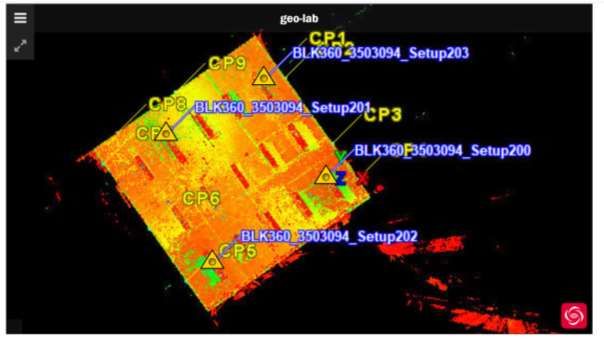
An Interactive Virtual Environment for Teaching Total Station Surveying
    Dimitris ANASTASIOU, Vangelis ZACHARIS, Vassilis PAGOUNIS, Maria TSAKIRI ,
                                     Greece

          1. INTRODUCTION

   In all early stages of surveying engineering training in relevant academic and other departments,
   the fundamental use and implementation for a number of survey instrumentation is compulsory.
   Whilst traditional teaching of these instruments is on a face-to-face basis where the instructors
   explain the methods to students individually, the students practice with the need of a partner
   and/or instructor until they feel confident enough to employ the instrument in further
   educational tasks. Recently, however, the e-learning approach has become a dominant delivery
   method across universities worldwide and virtual education has become a challenge not only
   for the education system but for the society as a whole.

   Efforts in e-learning tools to support surveying engineering teaching started well before the
   Covid19 era for the delivering of the class material in a simple approach (e.g. Soon, 2011). The
   e-learning approaches included online applications (e.g. Roberts & Gray, 2010) and offline such
   as the Computed Aided Learning (CAL) (Commission 2- Professional Education, 2010;
   Nicholson, 2007). Endeavours in simulation-based training tools for surveying equipment were
   presented in El-Mowafy et al. (2013) and Gulland et al. (2012) where a flash-based simulation
   tool for teaching differential levelling was developed. Similarly, Dib and Adamo-Villani (2013)
   developed a virtual environment for teaching differential levelling with sophisticated graphic
   design. Of similar foundation, Dib et al. (2014) reported another virtual environment tool and
   described a chaining module used to determined horizontal and slant distances. Furthermore,
   Garbanzo et al. (2016) created an online application in order to support students in field
   practices. This application was designed to test students’ measurements before they submit the
   final report and to show them where the errors might be made. Garbanzo and Lara (2018)
   developed a Web 2.0 application for differential levelling which was extended to include an
   interactive survey instructor to assist students of early stages in engineering degrees.

   Whilst there are many e-tools to support the knowledge on height and levelling instrumentation,
   it seems that there is a shortage of similar tools for topographic data collection using total station
   surveying. Understanding of terrain topology is a critical skill set that has to be developed by
   any surveyor who is involved in data collection. The training requires the use of total station
   instruments in the field. The fact that the total station training usually requires external
   environment for large distances it can pose at the same time few difficulties due to weather
   conditions. This has resulted in the development of virtual space training tools using Virtual
   Reality and Augmented Reality (VR/AR) technologies as an opportunity of exploring online
   training opportunities in geospatial education. For example, Chen et al. (2007) describe the
   cognitive and technological aspects of surveyors training “gamification” that culminated in the
   development of operation workflows of the 3D multi-user virtual learning environment

An Interactive Virtual Environment for Teaching Total Station Surveying (10957)
Dimitris Anastasiou, Vangelis Zacharis, Vassilis Pagounis and Maria Tsakiri (Greece)
FIG e-Working Week 2021
Smart Surveyors for Land and Water Management - Challenges in a New Reality
Virtually in the Netherlands, 21–25 June 2021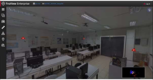
(3DMUVLE) educational game design framework. This research study demonstrates a very
   useful connection of the gaming application scenarios with learning outcomes and their
   assessments in the frame of virtual learning. The implementation of various surveying
   technologies and instruments in this gaming environment can be a complication factor for the
   creation of generic application scenarios. The most interesting work was performed in Wang et
   al. (2018) where online training was focused on digital terrain modelling practice.

   A recent interesting work by Levin et al. (2020) focused on developing an immersive
   visualization of terrain, virtual total station instrument and virtual surveyor with reflector
   installed on the virtual rod. The application scenario of the technology has the following stages:
   (1) student is installing total station on the optimal location; (2) students move virtual surveyor
   on the sampling points they consider to be important (3) contours are generated and displayed
   in 3D being superimposed on 3D terrain; (4) accuracy of terrain modelling is observable and
   measurable by comparing the sampling model with initial one.

   Certainly, there is still a gap between field surveying experience and virtual learning. The major
   reason is the great difficulty to properly simulate the field experience required with surveying
   instruments (such as cantering the tripod over the setting point, work with tribrachs, instrument
   levelling, reflectors, crew communications etc). Whilst the VR technology is rapidly
   developing and the experience is not comparable to any other techniques, the complexity to
   have complete hands-on experience in a virtual environment is still very challenging. In
   addition, dedicated hardware is required for students to participate.

   With view on the above, this paper presents an interactive learning realistic environment for
   aiding surveying students at the first few years of their studies to familiarise themselves with
   the total surveying measurement acquisition. The remainder of the paper gives in section 2 the
   methodology implemented to develop the interactive environment and section 3 provides the
   results from the implementation of the platform by the students attending the topographic
   surveying course of the University of West Attica in Greece along with relevant discussion.
   Section 4 gives the main conclusions of this work along with the challenges of current research
   in interactive educational environments for surveying studies.

          2. DEVELOPMENT OF THE VIRTUAL ENVIRONMENT

   The interactive virtual environment was based on a 3D model created using terrestrial laser
   scanning (TLS) techniques. Specifically, scans were acquired using the Leica Geosystems
   BLK360 laser scanner from the area of the Geodesy-Topography laboratory of the University
   of West Attica (UniWA), in Athens Greece. A total number of four scan were obtained with a
   resolution of 4mm and overlap between scans of more than 50%. The scans were joined in a
   single point cloud with an accuracy of better than 1cm (Fig.1). Finally, the merged point cloud

An Interactive Virtual Environment for Teaching Total Station Surveying (10957)
Dimitris Anastasiou, Vangelis Zacharis, Vassilis Pagounis and Maria Tsakiri (Greece)
FIG e-Working Week 2021
Smart Surveyors for Land and Water Management - Challenges in a New Reality
Virtually in the Netherlands, 21–25 June 2021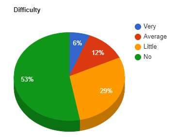
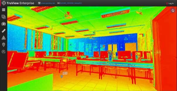
was exported to TrueView Enterprice format (.lgs) and uploaded to the experiment website
   TrueView Enterprise 3.8.7 - BLK360_3503094_Setup201 (Fig.2).

     Figure 1. View of merged point cloud from TLS data to create the 3D model of the virtual
                                          environment

An Interactive Virtual Environment for Teaching Total Station Surveying (10957)
Dimitris Anastasiou, Vangelis Zacharis, Vassilis Pagounis and Maria Tsakiri (Greece)
FIG e-Working Week 2021
Smart Surveyors for Land and Water Management - Challenges in a New Reality
Virtually in the Netherlands, 21–25 June 2021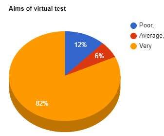
Figure 2. View of point cloud with number of control points

     Figure 3. Snapshot of the lab with control points for the total station surveying experiment

An Interactive Virtual Environment for Teaching Total Station Surveying (10957)
Dimitris Anastasiou, Vangelis Zacharis, Vassilis Pagounis and Maria Tsakiri (Greece)
FIG e-Working Week 2021
Smart Surveyors for Land and Water Management - Challenges in a New Reality
Virtually in the Netherlands, 21–25 June 2021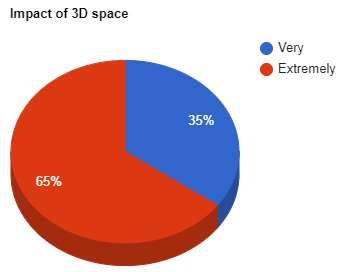
Figure 4. Plan of the laboratory with locations of all control points for the experiment

   Within the 3D model, a large number of control points as well as instruments set ups were
   measured in order to be used as targets during the virtual topographic measurements (Fig. 4).
   Specifically, thirteen points were implemented out of these nine are control points (CP), three
   are fixed points (B) and one is the location of the geodetic station (St). The checkpoints were
   marked using paper targets on the vertical masonry while the fixed points were marked using a
   permanent forced cantering base (Fig. 4).

   The coordinates of points CP7, CP9 και CP4 were given as:

                 Point                    X (m)                     Y (m)              H (m)
                  CP4                     1.322                    -0.031              -0.448
                  CP7                     -9.344                   0.675               0.881
                  CP9                     -6.304                   3.649               -0.036

   The measurements were carried out with a robotic geodetic station TRIMBLE S6 DR300 +.
   This station has a measurement accuracy of 3 '' angles and a distance of 3mm-2ppm with a
   capability to measure in a reflectorless way. An additional aspect for the correct execution of
   the experiment is the fact that the specific instrument is equipped with Vision Technology. This
   means that the instrument allows the user to see everything the instrument ’sees’ without a trip
   back to the tripod or be physically there by direct the survey with live video images on the
   controller. The robotic station was connected to a TSC2 controller which in turn "talks" to a PC
   connected to the internet. Regarding the software used to control the instrument during the
   virtual data collection, MyMobiler was used to connect the controller to the PC. This gives
   access to the screen of the controller terminal from a computer and allows the user total control
   of the device. The user can see on the computer what is displayed on the device screen by using

An Interactive Virtual Environment for Teaching Total Station Surveying (10957)
Dimitris Anastasiou, Vangelis Zacharis, Vassilis Pagounis and Maria Tsakiri (Greece)
FIG e-Working Week 2021
Smart Surveyors for Land and Water Management - Challenges in a New Reality
Virtually in the Netherlands, 21–25 June 2021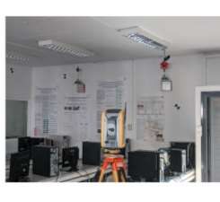
the mouse and keyboard via ActiveSync. Finally, the open access version of Teamviewer
   (15.12.4) was used for the remote connection to the PC.

          3. IMPLEMENTATION

   3.1 Measurement tasks

   The topographic surveying VR environment was accessed by the students through the website
   TruView Enterprise dedicated page. The virtual learning workflow consisted of (a) setting a
   total station position, (b) repetitive movement of the virtual reflector to the positions where
   sampling points were selected by the student for the measurements, (c) generation of
   measurements based on sampling points selected by students, (d) relevant calculations based
   on the values generated by the student measurements and comparisons with instructor-sample
   measurements. Technical implementation of the operational workflow was achieved by means
   of integration of the inexpensive mobile computing and state-of-the-art stand-alone inexpensive
   toolsets. Elements of gamification were introduced by a score defined by a minimal number of
   fixed points versus the higher accuracy obtained by measurements to the control points.
   Learning outcomes of the technology outlined here were (a) understanding the instrument set-
   up and the necessary action to make it ready for measurements, (b) comprehension of angle
   measurement procedure, (c) understanding of horizontal and vertical angle computation, (d)
   profound understanding of the field data collection during topographic surveying. Per the
   technology developed, these outcomes were achieved via the following processes: (1) student
   exposure to the virtual terrain topographic surveying with measurements of angle and distance;
   (2) exporting of the acquired data for processing and accuracy obtaining; (3) assessment of the
   learning outcomes numerically by means of final angles and derived coordinates and accuracy
   (using the 3D model and the derived values from the total station); (4) feedback of the
   assessment results to the student.

   The tasks that were given to the students referred to specific steps. Thus, given that at base point
   B1 is located a Trimble VX&S 360 prism with a target height of 0.325m and base points B2,
   B3 is located a Leica GPR111 prism with a target height of 0.325m, the students were instructed
   to follow the following measuring tasks and perform relevant computations (cf. Fig. 4):

   1. From position St1 measure the horizontal directions and the vertical angles to the points
      CP4, CP7 and CP9 in 4 periods. Calculate the corrected values of the above horizontal
      directions and vertical angles.
   2. Calculate the angles CP4-St1-CP7, CP7-St1-CP9, CP9-St1-CP4
   3. Calculate the coordinates of point St1.
   4. Calculate the horizontal coordinates and height of the base points B1, B2, B3.

An Interactive Virtual Environment for Teaching Total Station Surveying (10957)
Dimitris Anastasiou, Vangelis Zacharis, Vassilis Pagounis and Maria Tsakiri (Greece)
FIG e-Working Week 2021
Smart Surveyors for Land and Water Management - Challenges in a New Reality
Virtually in the Netherlands, 21–25 June 2021
3.2 Results
A sample of 52 students who performed the practical within the virtual environment were from
the second year of their studies at the Surveying Engineering course. After completing the tasks
described in section 3.1, a questionnaire survey was given to each student to assess the task
within the virtual environment. The 32 questions referred to the implementation of the
experiment by them under the guidance of their tutor and other quality remarks. Results from
indicative questions are given below. Fig. 5 indicates that the objectives of the virtual
experiment were for 82% of the students clear meaning that they could understand why they
were performing the experiment in this way. Fig. 6 refers to the level of difficulty of the
experiment. It can be seen that slightly more than half the students found the experiment easy
to follow for their year group while the remaining varied between average or some difficulty to
follow the experiment. This implies that although students are very familiar with virtual
environments through gaming or other social type exposure, they can still find difficulty in
using virtual environments for their learning. Another question referred to their opinion whether
the existence of a three-dimensional virtual tour of the measurement space helped them to
become better acquainted with using a total station and obtaining measurements. It is clearly
seen from Fig. 7 that all students agree that their understanding of obtaining data from a total
station was aided by the use of a 3D environment. The majority of students commented
positively that the material explaining the test was sufficient to understand their task. In the
same way, the students agreed that they had adequate guidance from their tutor and sufficient
infrastructure to perform the virtual experiment.
Figure 5. Assessment of the objectives of Figure 6. Difficulty of the experiment
the experiment
An Interactive Virtual Environment for Teaching Total Station Surveying (10957)
Dimitris Anastasiou, Vangelis Zacharis, Vassilis Pagounis and Maria Tsakiri (Greece)
FIG e-Working Week 2021
Smart Surveyors for Land and Water Management - Challenges in a New Reality
Virtually in the Netherlands, 21–25 June 2021Figure 7. Impact of 3D space on student’s understanding 3.3 Discussion The development of the virtual environment and the presented experiment highlighted that, for as long as the pandemic continues and distance education is the only approach, this tool may be used to a wide range of students (from early years to seniors) for their training to total station data collection. It should be noted that this approach is not a stand-alone education tool but supplements the lectures and other education tasks. However, it has many benefits in that allows students from early semesters to get acquainted with the main surveying instruments equipment and the primary observations of angles and distances. In later semesters, students can use such virtual environments to enhance their skills and further their knowledge by more complex tasks. The use of robotic geodetic stations enables students to better understand concepts that had only heard in theory or at best had a limited exposure using such equipment. Measuring with the robotic geodetic station in two telescope positions is a process that is done automatically and with great accuracy. By creating the three-dimensional model of the measurement space, the student can browse and better understands the space where the measurements take place. In addition, when working in the 3D space, the students familiarise with another modern methodology and technology, that of 3D scanning. Educationally, the experiment allowed students to have high repeatability of their observations which were independent of conditions (meteorological and time). During recent years and even more now during the pandemic era, it has been shown that virtual environments for education have shown good potential to expand learning domains in classroom environments. By using simulated environments, teachers can shift the focus from plain learning to an interactive learning environment. There are however problems to be considered, such as effective infrastructure to support these activities. The developed environment as for now contains only an internal laboratory space but in reality, this has to be expanded to include physical landscape with ground features that can be objects of interest or even obstacles during a survey, especially obtaining a line of sight. In more complex environments, the students will have to take decisions regarding on the location of the stations and the ground points to be collected. Other surveying techniques, such as levelling and GNSS surveying can be incorporated to allow for more complex surveying scenarios. An Interactive Virtual Environment for Teaching Total Station Surveying (10957) Dimitris Anastasiou, Vangelis Zacharis, Vassilis Pagounis and Maria Tsakiri (Greece) FIG e-Working Week 2021 Smart Surveyors for Land and Water Management - Challenges in a New Reality Virtually in the Netherlands, 21–25 June 2021
4. CONCLUDING REMARKS

   Given the limitation or complete lack of face-to-face classes in academic organisation due to
   the recent pandemic, this paper has demonstrated the feasibility of virtual environments for
   training topographical and surveying skills within the scope of an educational tool. Such
   technologies must be used in parallel with the main educational methods and can be considered
   as a reasonable extra tool to traditional field practise. Certainly, the field practise cannot be
   replaced by virtual environments as the complete hands-on experience is crucial for performing
   the surveying tasks. Nevertheless, with the increase of cloud-based computing, it can be
   anticipated that future efforts can encompass the development of more complex and realistic
   virtual environments for surveying training.

   ACKNOWLEDGEMENTS

   It is acknowledged that financing of this publication is provided by the University of West
   Attica, Greece.

   REFERENCES

   Cheng, S.F, Chiang, T.Y., Lien, L.C., 2007. Virtual reality learning system for digital terrain model surveying
      practice. Audio-Vis. Educ. Bimon (48): 1–18.
   Commission 2- Professional Education, F.I.G., 2010. Enhancing Surveying Education through e-Learning. The
      International Federation of Surveyors (FIG).
   Dib, H. & Adamo-Villani, N., 2013. An Interactive Virtual Environment for Learning Differential Leveling.
      Global Journal on Technology, 3.
   Dib, H., Adamo-Villani, N. & Garver, S., 2014. An interactive virtual environment for learning differential
      leveling: Development and initial findings. Advances in Engineering Education (ASEE).
   Garbanzo-León, J., Kingdon, R. & Stefanakis, E., 2016. GEOWAPP: A geospatial web application for lab
      exercises in surveying. Geomatica, 70(1).
   Ghilani, C. & Wolf, P., 2012. Elementary Surveying: An Introduction to Geomatics 13th ed., New Jersey: Pearson.
   Gulland, E.K., El-Mowafy, A. & Snow, T., 2012. Developing interactive tools to augment traditional teaching and
      learning in land surveying. In Creating an inclusive learning environment: Engagement, equity, and retention.
      Proc. 21st Ann. Teaching Learning Forum.
   Nicholson, P., 2007. A history of e-learning. In Computers and education. Springer, pp. 1–11.
   Levin E, Shults R , Habibi R , An Z, Roland W, 2020. Geospatial Virtual Reality for Cyberlearning in the Field
      of Topographic Surveying: Moving Towards a Cost-Effective Mobile Solution. ISPRS Int. J. Geo-Inf. 2020,
      9, 433; doi:10.3390/ijgi9070433
   Roberts, G. & Gray, J., 2010. Nest- A New Web Based Teaching Tool for Engineering Surveying. Proc. FIG 2010,
      Sydney, Australia.
   Soon, L., 2011. E-learning and m-learning: challenges and barriers in distance education group assignment
      collaboration. Int J of Mobile and Blended Learning (IJMBL), 3(3), pp.43–58.
   Wang, P., Wu, P., Wang, J., Chi, H.-L., Wang, X. A., 2018. Critical review of the use of virtual reality in
      construction engineering education and training. Int. J. Environ. Res. Public Health (15)1204.
   Wolf, P. & Ghilani, C., 2012. Coordinate Geometry in Surveying Calculations. In Elementary surveying : an
      introduction to geomatics. Upper Saddle River, N.J.: Prentice Hall, pp. 289-291-299.

An Interactive Virtual Environment for Teaching Total Station Surveying (10957)
Dimitris Anastasiou, Vangelis Zacharis, Vassilis Pagounis and Maria Tsakiri (Greece)
FIG e-Working Week 2021
Smart Surveyors for Land and Water Management - Challenges in a New Reality
Virtually in the Netherlands, 21–25 June 2021
BIOGRAPHICAL NOTES CONTACTS Dr. Dimitris Anastasiou University of West Attica Ag. Spyridonos Str., PC:12243 Egaleo, Athens GREECE Tel. +30 2110129498 Email: dganastasiou@gmail.com Mr. Vangelis Zacharis National Technical University of Athens (NTUA) 9 Heroon Polytehnious Street, Zografos Campus 15780 Athens GREECE Tel. +302107722754 Email: vanzach@mail.ntua.gr Prof. Vassilis Pagounis University of West Attica Ag. Spyridonos Str. Egaleo GREECE Tel. +30 2105385820 Email: pagounis@uniwa.gr Prof. Maria Tsakiri National Technical University of Athens (NTUA) 9 Heroon Polytehnious Street, Zografos Campus 15780 Athens GREECE Tel. +30 2107722735 Email: mtsakiri@central.ntua.gr An Interactive Virtual Environment for Teaching Total Station Surveying (10957) Dimitris Anastasiou, Vangelis Zacharis, Vassilis Pagounis and Maria Tsakiri (Greece) FIG e-Working Week 2021 Smart Surveyors for Land and Water Management - Challenges in a New Reality Virtually in the Netherlands, 21–25 June 2021
You can also read