Arq. en Aguas Profundas I - Introducción
←
→
Page content transcription
If your browser does not render page correctly, please read the page content below
Arq. en Aguas Profundas I
Especialización en Patrimonio Cultural Sumergido
Cohorte 2021                                       Introducción

Filipe Castro
Bogotá, April 2021
Archaeologists try to reconstruct the past from the remains
of past human activity.
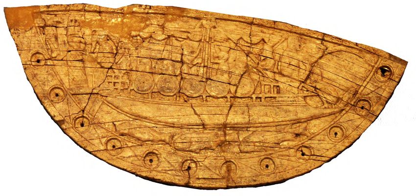
Nobody knows what an Athenian trireme
looked like.
All we have is a ram (190 BCE)…
…a few timbers
preserved inside it…
…and some sculptures:
Maritime archaeology is
concerned with the study
of seafaring and maritime
cultural landscapes.

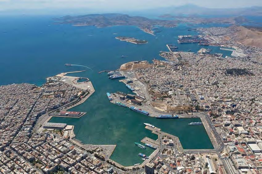
Piraeus has
been an
important
harbor for
the best part
of the last 25
centuries.

We study shipwrecks to try to understand the people that built and sailed
them, and the world in which they sailed. The history of warship design is
largely unknown to us...

                                                                 …
…but we are also interested in the everyday lives of the peoples that
manned and inhabited the ships.


Archaeologists rarely try to work beneath air / nitrox diving
depths.
The salvage industry has a long experience recovering cargos
from shipwrecks.

The depths of operation of salvage companies increased
steadily during the 20th century, and after the treasure hunting
boom of the 1960s, treasure hunting companies started
looking into cargos sunken in deep water.

Harrisburg telegraph. (Harrisburg, Pa.),
19 July 1916.
                                           Sorima’s salvage of the gold of
                                           Egypt, 1930.
Treasure hunters have more resources, as their money is in the pockets of the investors, not on the bottom of the sea.
In 20107 Greg Stemm recovered
17 tons of silver coins from a
Spanish shipwreck c. 1100 m deep.
                               Treasure hunters destroy the sites they salvage
A few attempts were made to work in deep water, following
archaeological standards.
Ormen Lange, Norway, 2003Deep sea archaeology is in its infancy and marine
robotics is the answer to the most relevant
problems.
Archaeologists work within a 19th century paradigm, and what
we do can be roughly divided into four main activities:
1. Surveying;
2. Excavating;
3. Conserving; and
4. Publishing.Although it is expensive, research in archaeology
can be justified by its social value. And if marine
robots can do archaeology, they can do anything.
Low depth marine archaeology can be a good testbed
for marine robotics:
1. Shipwrecks frequently occur in places with currents and waves;
2. Often deep;
3. Often in places with low visibility and suspended sediment;
4. Marine archaeology requires surgical precision;
5. It generates large amounts of data that need to be synchronized,
stored, migrated, classified, and analyzed, in order to allow for
interpretations of the sites and reconstructions of the past.1 Surveying requires an array of remote sensing tools:
a. Magnetometers;
b. Side scan sonars;
c. Multibeam echosounders;
d. Video;
e. Photography;
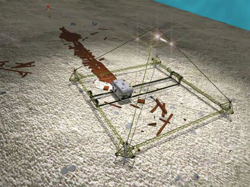
f. Sub-bottom profiling.Ground truthing generally requires diving or the use of
ROVs.
Besides cost, survey problems include:
a. AUV payload;
b. AUV autonomy;
c. AUV stability (pitch, roll, and yaw control);
d. AUV path control;
e. Communications (data migration).Related problems are:
a. Data integration;
b. Interaction of multiple vehicles collecting data at the
same time (e.g. sonar and magnetometer).Ultimately, the main goal of a collaboration between marine robotics and archaeology would be the acquisition of accurate data. Computer Science: Pierre Drap (CNRS) and the c. 700 BC Xlendi shipwreck, Malta.
2 Excavation consists of six main tasks:
1. Mapping
2. Digging
3. Cleaning
4. Tagging
5. Recording (plans and sections)
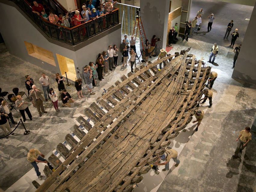
6. Covering, or raising and conservingChevalier de la Salle’s Belle, 1686 Archaeologists destroy the sites they dig and must record everything they find as carefully as possible.
In this project, to overcome the problems created by the strong
currents and low visibility, a cofferdam was built around the wreck
site and the water pumped out.
The excavation was carried out by the Texas Antiquities Committee
between 1996 and 1997.
The hull was disassembled, each timber
recorded separately, cleaned, and
reassembled before conservation treatment
started.
Taras Pevni:
After conservation the hull was exposed in Austin, at
the Bullock Texas State History Museum, and an
attempt to reconstruct the ship and its rigging was
made.
The excavation process is always the same: map, dig, clean, tag,
record (sketch, measure, and draw plans and sections), and cover.

                         Cais do Sodré shipwreck, Lisbon (C14 dated to c. 1500)
Coral Eginton
Thomas DerryberryCoral Eginton
?
Ships have a stratigraphy in themselves: they were built
following a traditionally established construction sequence.

                                                        Alex Hazlett
We want to reconstruct them, populate them, and understand the world in which they sailed:
Cody Leuschner
Bruce Gooch’s student
Traditionally mapping was done with sketches
and metric tapes, levels, and scales:
Several alternatives to the use of grids have been tried, with
different levels of success.
Triangulation from datum points, an alternative to the use of grids, was
greatly simplified with the development of dedicated software (1980s).

     Nick Rule’s DSM                            3H Consulting Site Recorder Software
From the beginning, photography
looked like the archaeologist’s
best friend.Photogrammetry has been
around since the 19th century,
and its applications in maritime
archaeology were obvious
because bottom time is often
scarce and expensive.
Experiments with photogrammetry at
As long as there is visibility… Yassiada 2 (4th century) in the 1960s.Marine robotics brought about the possibility of making images – photography or video – with remotely operated or autonomous vehicles.
Photogrammetry software made it possible to transform large
batches of pictures into tridimensional color meshes of points
or into large orthogonal, scaled photos.
PhotoModeler

                                                       PhotoScan
From scaled meshes of points, archaeologists make their site plans.
Pierre Drap LSIS-CNRS…sometimes by
hand.…sometimes using off the shelf drafting software, such as AutoCAD (2D), Adobe Illustrator, Corel Draw, or Inkscape (open source), more often using GIS.
Three dimensional site maps can be obtained with off the shelf
software as well.

Thomas Derryberry

                                                        Coral Eginton
Again there are
many software
packages
available,
although the best
require a level of
mastery that is
time consuming to
acquire.
Corpo Santo shipwreck,
Lisbon (C14 dated to c. 1400)
Kevin GnadingerAutoCAD (3D) is sometimes used but requires some level
of training. Many archaeologists prefer Rhinoceros.
Helena Rua and Pedro Alvito, “Living the past: 3D models, virtual reality and game engines as tools for supporting archaeology and the reconstruction of cultural heritage – the case-study
of the Roman villa of Casal de Freiria,” in Journal of Archaeological Science (2011) 38.12: 3296–3308.Rhinoceros became extremely popular in the last decade and is
perhaps the most commonly used software among archaeologists.
Recorded with FARO Arm,
assembled in Rhinoceros, and
printed. Toby JonesIts rendering capacity is poor (there are no
lines, just surfaces), but this problem is easily
solved with a renderer plugin (Penguin).
Thomas DerryberryAutodesk Maya is a powerful
software but difficult to
master.
Audrey WellsWe made a procedural modeling experiment with Houdini
that showed very promising options.
Matt Suarez
Andre Thoma’s idea3.
Conserving is perhaps the most complex task because the
UNESCO Convention for the Underwater Cultural Heritage makes a
strong case for the protection of archaeological sites in situ.
That entails the development of a number of tools that either don’t exist or are too expensive to be used:
a. Finding the sites and rigorously limiting the area where cultural remains are spread;
b. Characterizing the sites, mostly with non-intrusive
technology (limited trenching and sub-bottom profiling);
c. Developing diagnostic tools and procedures (involving
biology, chemistry, geology, etc.) to assess the site’s
stability;
d. Developing prognostics (what happens if we don’t touch, what happens if we cover the site, etc.);
e. Developing mitigation procedures and techniques;
f. Develop assessment tools to monitor the in situ sites periodically.a. Finding the sites and limiting the area where cultural remains are spread
b. Characterizing the sites, mostly with non-intrusive technology (limited trenching and sub-bottom profiling);
c. Developing diagnostic tools and procedures (involving biology, chemistry, geology, etc.) to assess the site’s stability;
d. Developing prognostics (what happens if we don’t
touch, what happens if we cover the site, etc.);

Anthropic factors include looting, dredging, trawling, etc.
We catch 160 million tons of fish each year; 25% of the world fisheries are illegal; there are around 2 million decked
fishing boats (84k in the EU); they discard 84k tons of nets every year; most shipwrecks 500 m and above have
nets over them; artifacts turn up every day in fish markets: there is a market for archaeological artifacts and one for
paleontological materials.
e. Developing mitigation procedures and techniques;
f. Develop assessment tools to monitor the sites periodically.
4.        Divulgation is undoubtedly the most important task.
It may involve several types and levels of outreach:
    a. Through archaeological reports and peer reviewed papers;
    b. Through magazine articles for the great public;
    c. Through internet videos and television shows;
    d. Through computer animations and computer models that allow the public to experience these
    sites;
    e. Through augmented reality, that allows the visitors to question the sites and understand them
    better;
    f. Through the involvement of sections of the public and the creation of fora and the development of
    public archaeology projects: these may entail educated reconstruction of shipwrecks and computer
    modeling of intact stability, mechanisms of collapse, seakeeping, etc.
    g. Through the creation of learning environments and serious games.
What is the social value of archaeology?! It provides the world with thinking tools! “We cannot do much carpentry with our bare hands, and we cannot do much thinking with our bare brains.”
Will archaeologists start publishing their excavations?

Archaeologists probably publish around 25% of the sites they dig (e.g. Stoddart and Malone 2001; Atwood 2007; Boardman
2009; Owen 2009; Bass 2011). Treasure hunters fill the niche created by archaeologists and cater to the interested public.
Will archaeologists share their primary data?
“…our past provides apps that we upload to our necktops.”

                    San Pedro de Alcantara
                    (1784)
San Pedro de Alcantara (1784) transported Fernando Tupac Amaru Bastidas, the son of José Condorcanqui (Tupac Amaru II) who was forced to witness the execution of his parents and died in exile in Spain.
Outreach: technology is changing everything,
starting with   museums:
Questions?
You can also read