Upper Motueka - Hydrology Surface/Groundwater Shedwood Hall, Tapawera - Monday 15th February 6.30 PM - NZ Landcare Trust
←
→
Page content transcription
If your browser does not render page correctly, please read the page content below
Upper Motueka – Hydrology
    Surface/Groundwater
Monday 15th February 6.30 PM
  Shedwood Hall, Tapawera
              Joseph Thomas
     Senior Resource Scientist – Water
          Tasman District Council

              “Making Tasman Great”

                                         1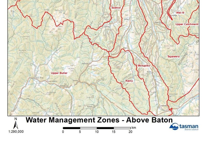
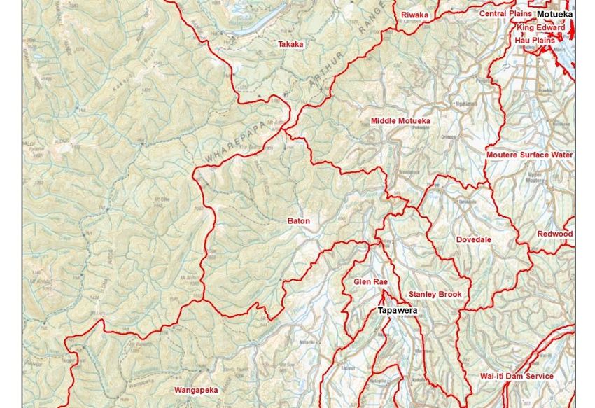
Upper Motueka -
Catchments

Re: Area above Woodstock – includes
Dovedale
Baton
Stanley Brook
Wangapeka
Glen Rae
Tadmor
Tapawera
Motupiko & Sherry

                                      “Making Tasman Great”

                                                              2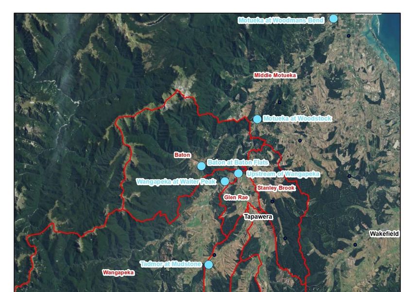
“Making Tasman Great”
We have a number of sites with flow meters that measure river flow over 24 hours
They can be found on the LAWA website they can be found on the LAWA website
Eg https://www.lawa.org.nz/explore-data/tasman-region/water-quantity/monitoring-
sites/motueka-at-woodmans-bend/
River flow information is used by lots of different people including fisherman and kayakers in the
Buller
We have flow records write back to the 1950's and other started in the 1980s so we have a really
good historical database
Flowmeters can be used both for flood warnings but also for assessing low water flows
3
4
Water Resources Investigation Work
• Some work for the Water Conservation Order in the 90’s
• Significant work from 2001 onwards as part of the ICM project
• Ongoing summer river flow measurements – numerous sites
• Groundwater level sites/surface flow sites – maintained and correlative sites for surface
water (involves temporary flow sites)
• Involved Cawthron/Landcare/GNS/TDC
Hydrology – surface and groundwater/ Modelling/Allocation
Ecology
Landuse/Landcover
Community & Iwi
• Numerous Reports completed to 2013
• TRMP Plan work Monitoring in Upper Motueka – since 2015/2016
• Recent Review Work Cawthron and Landcare completed in November 2020
• Ongoing work and recommended above to 2024.
In the past lots of money has been spent on studying water and water flows. This was done before
the water conservation order. The water conservation order hearing was held and the order was
signed in 2001. Fish and Game were the applicant for the water conservation order.
From the early 2000s an integrated catchment research project was commenced for the Motueka
river. This involved many water flow and water quality measurements conducted by Cawthron,
Landcare Research and Tasman District Council. A cultural health index was also used on the river.
https://icm.landcareresearch.co.nz/
5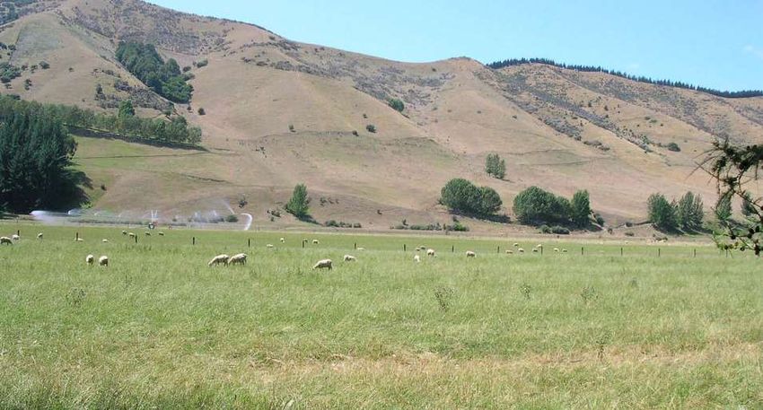
Pictures of
the Upper Motueka
Catchment

                      Upper Motupiko valley             Lower Motueka River valley

                    Lower Motueka River valley          Lower Motueka River valley

                                      Motueka River lower valley

                                                                                     6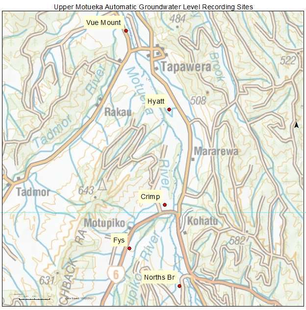
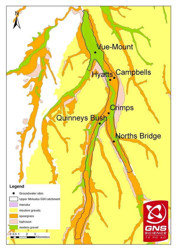
Hydrogeology in the Upper Motueka catchment
• A shallow unconfined alluvial aquifer located on Quaternary river terrace formations and
modern river deposits – highly connected to the rivers. River and rainfall recharge dominant,
hillslope recharge less. River and groundwater have short residence time
• The river terraces are composed of five different Quaternary gravel formations: (1) Moutere
Gravel; (2)Manuka Gravel; (3) Tophouse Gravel; (4) Speargrass Gravel; and (5) modern river
Gravel formations.
• The Quaternary gravels are underlain by the Moutere Gravel Formation throughout the
whole study area. No appreciable groundwater has been found in the Moutere Gravel here.
• The Moutere Gravel is widespread throughout the catchment and forms the hill country
between the valleys of the Motueka, Motupiko and Tadmor rivers
Quaternary river terrace formations Tophouse and Speargrass formation terraces
Moutere Gravel cliff faces on the Motupiko River
between Tapawera and Kohatu
Motueka Aquifer
This is a shallow aquifer.
It is open to the atmosphere and is not sealed.
It is highly connected to the river.
It is largely charged by rainfall and river flow.
Not much of the water comes from the hills.
Itt is very young water only months to a year old.
Waikourupupu Spring which is approximately 10 years old.
The Motueka catchment is made up of five different River terraces.
It is the only the youngest terrace close to the river that has water.
All the hills and higher terraces have no water aquifers.
This is indirect contrast in Moutere catchment which has deep groundwater.
The Motueka aquifer is directly taking water from the river.
7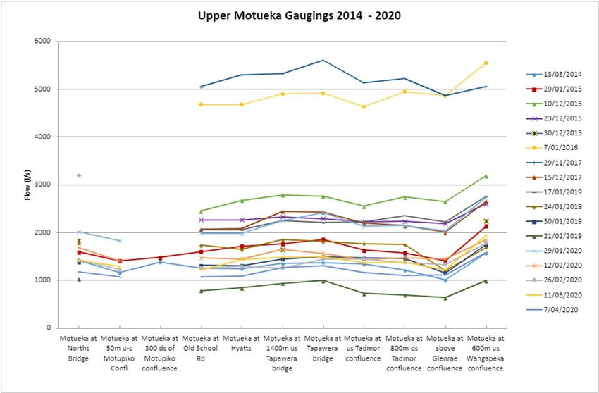
The gravels containing the water are only 10 metres.
7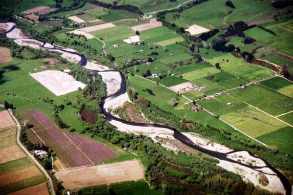
Groundwater potential for each geological formation (Stewart et al., 2003)

When you get to the Glen Rae the water rises because it is pushed up by hard granite rock
Green is the acquifer where the water is found

                                                                                            8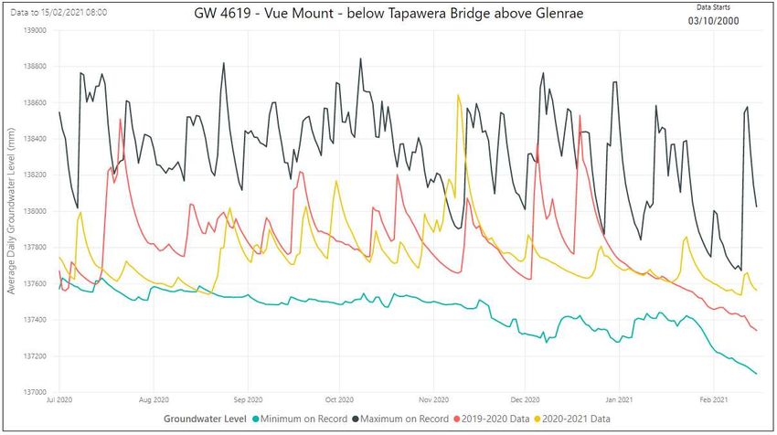
Cross section – Geology
Tapawera Kohatu
500
LEGEND
Modern gravels and
4617
400 recent fan deposits
Bore (TDC bore number) LEGEND
Speargrass Formation
Modern gravels and
4617
Groundwater level in bore
recent fan deposits
Tophouse Formation Bore (TDC bore number)
Inferred groundwater table Speargrass Formation
400
Groundwater level in bore
Manuka Formation
Tophouse Formation
Inferred groundwater table
Metres above sea level
Moutere Gravel Formation
Metres above sea level
300 Manuka Formation
Moutere Gravel
300
Motueka River
200 Tadmor River
4820
4618
4617
Motupiko River Motueka River
4615
4616
200
100
160
0 1 2 3 4 5
Kilometres 3
A A'
0
B
1
Kilometres
2
B'
9Upper Motueka Water Management
Councils Updated water provisions (TRMP)came into effect July 2017
Motueka River also subject to Water Conservation Order (WCO) and
also Plan Triggers for this based on Woodstock and the updated zone
triggers from 2017
“Making Tasman Great”
In 2017 the council updated their plan and introduced triggers for restricting water based on what was happening in
Woodstock. They also introduced other monitoring sites at Wangapeka in the Baton. Some of these other subcatchments
behave a bit differently than the main Motueka River.
10Allocation Limits for Freshwater Takes
Upper Motueka Zones Allocation limit l/s
Baton 54
Stanley Brook 1.05
Dovedale - Groundwater (to 8 metres) 13.2
- Surface water 26.8
Middle Motueka Zone 550
Wangapeka 265
Motupiko 85
Rainy Zone 25
Tadmor (total augmented flow) 56
Tapawera 314
Glen Rae 300
“Making Tasman Great”
11Triggers for Rationing and Minimum Flows
Trigger for First Rationing Trigger for
Minimum Flow
Water Management Zone Location Step Consultation
(l/sec)
(l/sec) (l/sec)
Upper Motueka Zone
Motupiko, Rainy, Tapawera,
Woodstock Subject to WCO 7000 7500
Glen Rae, Baton, Wangapeka
Tadmor River Mudstone Weir Subject to WCO 128
Downstream of
Hope River 20 None
diversion weir
Rainy Christies 203 250 400
Motupiko Christies 250 400
Motueka River, above
Tapawera, Glen Rae the Wangapeka 1400
Confluence
“Making Tasman Great”
12Water user committees will be consulted when rationing triggers are reached.
The minimum flows for Middle and Upper Motueka zones will be consistent with the Water Conservation
Order for the Motueka River.
The Council will implement rationing to comply with the Motueka WCO flow extraction limits of 12% above
Woodstock, and 6% for Wangapeka above Walter Peak. It will also implement rationing to protect river
flows in contributing tributaries.
Council will use correlation and actual flow measurements to manage Tapawera and Glen Rae Zones
In the Rainy and Motupiko zones, Step 2 rationing will commence at 200 litres per second and Step 3 at 180
litres per second. Used S329 for cease take at ~150 l/s
Specific restrictions and cease take in Consent for Rainy – 203 l/s
If water flows or levels decrease below the minimum flows or levels specified in this schedule and the
provisions of the rationing steps given in the TRMP are exceeded, the Council may issue water shortage
directions (S329) in accordance with its policies“Making Tasman Great”
Land owners are subjected to reductions in take or stop takes, based on water flow triggers for rationing water. The plan
specifies the proportion of water that can be taken.
All water extractions are metered. When it is dry and lots of water has been taken from the river, river flows can drop
quite quickly.
13Water Resource Considerations for Summer Restrictions
in Upper Motueka
River Flow and Aquifer Levels and rate of decline and when
Rainfall
Water Usage
Temperature
Wind
Evapotranspiration
Timing – of peaking of different use
“Making Tasman Great”
14Catchment Hydrology Information
• Rainfall
• River Flows
• Groundwater
The last 3 years of being dry relative to the average.
A flow recorder cost 20k so to reduce costs we have developed predictors between different sites along the river. This
allows us to optimise the measurements of flow at the key points when assessing flow we use the 7-day average.
We have started to collect data from bores so that we can keep a better eye on the aquifer. All the data is stored on the
LAWA website.
We are also recording temperature at 7 sites along the River.
1516
17
18
19
20
•   We have developed predictors between different sites along the river.
•   This allows us to optimise the measurements of flow at the key points.
•   When assessing flow we use the 7-day average.
•   We are getting reasonable prediction of river flows.
•   R2 of 0.877 means that 87% of the variation of flow of water at Tapawera is explaind by flow at Wangapeka

                                                                                                                21
22
The river has more flow than it did last year at the same time of year

                                                                         23
24
25
We are also measuring groundwater over recent years

                                                      26
27
Current Work in the Upper Motueka

  • Low flow and temperature measurements in river between Kohatu
    and Wangapeka Confluence (last 4 summers – flow dependent) as
    well as Motupiko last summer
  • Water Take Monitoring of all consents (metered)
  • Water quality run along river from Kohatu to u/s Wangapeka
    confluence
  • Dissolved Oxygen – now added at Kohatu and U/s of Wangapeka
  • Cawthron/Landcare – review of monitoring – November 2020

                                                       “Making Tasman Great”

• We are recording temperature at 7 sites along the River.
• The River gets very warm. Some people think that it's the irrigation making the water warm. But it's much more likely
  that it's the exposure of the River to the sun. There is limited cover on the riverbank.
• There is not an easy solution because the River is very wide.
• We are monitoring water take from the River, flows and we have two permanent oxygen sensors in the River that
  record oxygen levels over 24 hour periods over summer.
• Cawthron and Landcare Research did a report reviewing our data collection and made some recommendations which
  we are implementing.
                                                                                                                          28
Cawthron/Landcare Recommendations
• Continue all current monitoring and;
• Trial fixed cameras to record river drying at lower Motupiko and Tadmor
• Update river/aquifer model
• Annual monitoring of water clarity, nutrients, faecal indicator bacteria,
macroinvertebrate community and periphyton cover at Motueka River u/s
of Motupiko confluence and Motueka u/s Wangapeka confluence
• Snapshot summer surface water quality at multiple sites in conjunction
with planned synoptic groundwater quality survey
• Review data and plan 24/25
• One of the recommendations was to include cameras and data loggers along rivers that run dry so we can tell when they run dry.
• Some people are concerned about the water aquifer and about all the recent hops taking all the water at the same time of the year. We are
going improving our knowledge of the aquifer. We are going to review the data and then look to see if any changes are needed in the 24/25
plan .
29Questions?
“Making Tasman Great”
How can we support as a community the water quality sampling ?
The council can provide expertise and may be able to accommodate sampling but water sampling has big costs. We could
potentially loan equipment eg temperature loggers or O2 measurements.
But there is a very strict methodology for water quality testing on how sample is collected, stored and what labs should
be used when water quality sampling. Samples often have to arrive at the lab within 24 hours.
Is there an issue with nitrates in our water? There is a rumour going around that the local testing of the Tapawera water
supply showed and increase in nitrates. They had increased from 2 to 4 mg/L but are still well below the 11 mg/L.
The council is sampling other wells throughout the region.
The latest few nitrate samples collected from Tapawera had fallen. So it's not a concern at the moment but needs to be
watched.
Two years ago in Murchison the aquifer was tested for pesticides ($1500/sample). No pesticides or Roundup was found
in the water.
If we do need to reduce water allocation how will it be done? There are a number of smaller water users that are
concerned that if they don’t use all their water allocation they will loose it. So they are putting water on when they don’t
really need it.
30It is undecided at this point. With water permits we do look at the history of the water use to base the new permit. But we don’t
encourage inefficient water use. Rather I suggest that if you don’t use your allocation you could lease out your water allocation
on a short term lease to someone else.
There are a number of options we could set target water reductions including not allocating any new water permits, we could
reduce everyone intake on a percentage basis. As a current general guidelines at the moment if you use 80% of your water intake
you can still renew it at 1.00%
30What are the new things on the horizon around water quantity? Everyone will need a farm environmental plan. Irrigators will need soil moisture probes. Next time you go to get your water allocation you will need an irrigation plant. Should we be worried about heavy metals coming out of tanilised posts? Heavy metals tend not to be very mobile. Painting the top of the poles reduces the movement of chemicals out of the posts. Marlborough studies have shown the chemicals don’t more far from the post and become bound to the soil. Can we pose forestry limits in the catchment? TDC can only place limits of forestry in areas with
Scion is recommending sparse plantings to retain some pasture. Alternatively a pasture area could be retained on the paddock
side of the riparian planting. Flaxes and sedges can help capture flow.

What were the findings from Donald Creek?
. This paired catchment study conducted by Andrew Fenemore had a lot of good information.
While Andrew Fenemore has retired he is keen to retain links with the Motueka catchment and sent his apologies for missing this
meeting.
Cawthron is collecting allot of information on sediment in the Motueka Catchment.

                                                                                                                                  31
Upper Motueka Current Status and Outlook
• River Flows - about average for this time
• Aquifers – about average for this time
• Eastern Part of Tasman Drier – Motupiko/Wai-it/Dovedale/Waimea/Moutere to Motueka Plains
along the coast
• Many dams not full e.g. Moutere dams a bit of pumping from groundwater to storage
• Wai-iti Dam (Wai-iti Zone) ~ 85 % full
• Short term outlook (10 days) – only minor rain
• Current Rainfall in Upper Motueka behind averages except Wangapeka
• Early in the season for peak demand ~ Jan to Mid March
• Continue close monitoring of all water use including hops
• Note; Small Nature of Catchments and Aquifers – things can turn quickly – when dry/windy and
water usage increases
“Making Tasman Great”
32Seasonal climate outlook Dec – February 2021 – NIWA
Currently a “La Nina” pattern is predicted for NZ – wet in the north, dry in the south and
warm
Probabilities are assigned in three categories: above average, near average, and below average.
Temperatures are very likely to be above average (70% chance).
Rainfall totals are about equally likely to be near normal (40% chance) or above normal (35% chance).
Soil moisture levels and river flows are most likely to be near normal (40% chance).
Temperature Rainfall Soil moisture River flows
Above average 70 35 30 30
Near average 20 40 40 40
Below average 10 25 30 30
33You can also read