ASIAN ALPINE E-NEWS Issue No 89. June 2021 - Contents
←
→
Page content transcription
If your browser does not render page correctly, please read the page content below
ASIAN ALPINE E-NEWS

               Issue No 89. June 2021

                       Contents

“Tibet Now” Development, Traditions and Mountains
―No Longer Frontier―      Tamotsu Nakamura          Page 2 ~ 45

1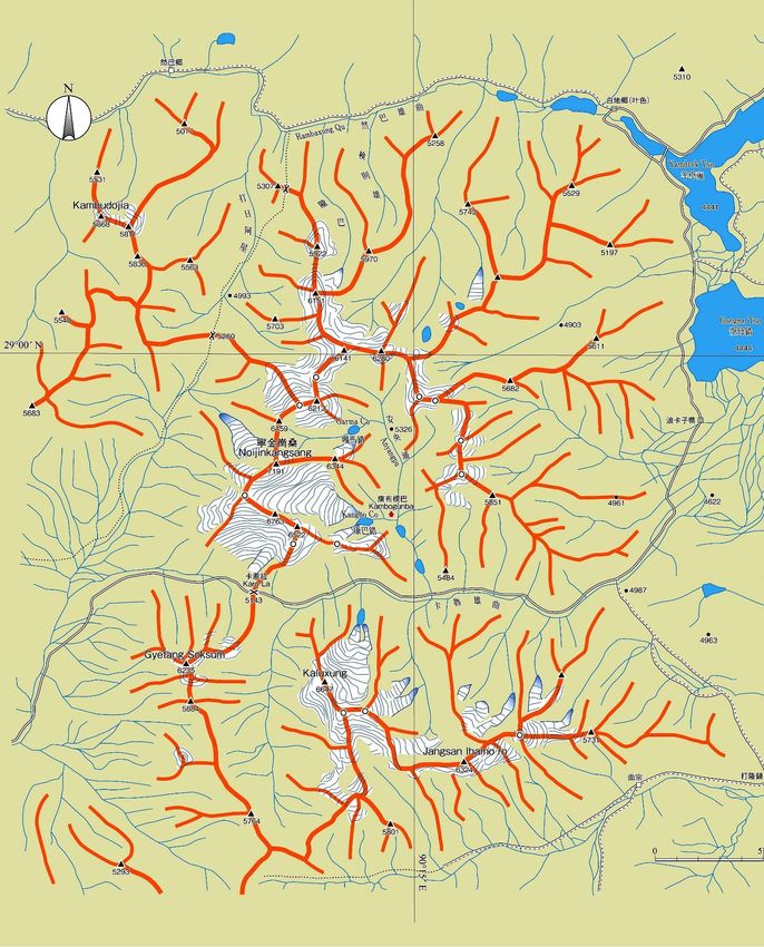
“Tibet Now” Development, Traditions & Mountains – T. Nakamura
I visited Tibet Autonomous Region in autumn of 2019 after three years. In the previous year
I had travelled through Qinghai Province. The rapid change of Tibetan Marches was far
beyond my imagination. Development of China as “Civil Engineering Work Great Nation”
was widely spreading unlimitedly throughout China.
“Frontier” is already an obsolete word in Tibet. Railway and highway network is expanding.
People are in a hive of activity. Xi Jinping has announced that a total highspeed railway of
50,000km would connect towns and cities all over the Chine in future.

Nyainqentanglha West Mountains

1
Two ring roads around Lhasa city are in now in services. New highway to Nagchu is under
construction in parallel with the Qinghai-Tibet Plateau Railway shown below.

       Highway (foreground) and Qinghai-Tibet plateau Railway (background)

Magnificent 7,000m snow-covered peaks of West Nyainqentanglha Mountains are seen
within hailing distance. This mountain range spreads southwest to northeast in north of Lhasa,
a provincial capital of the holy city of Tibet Autonomous Region (TAR).

2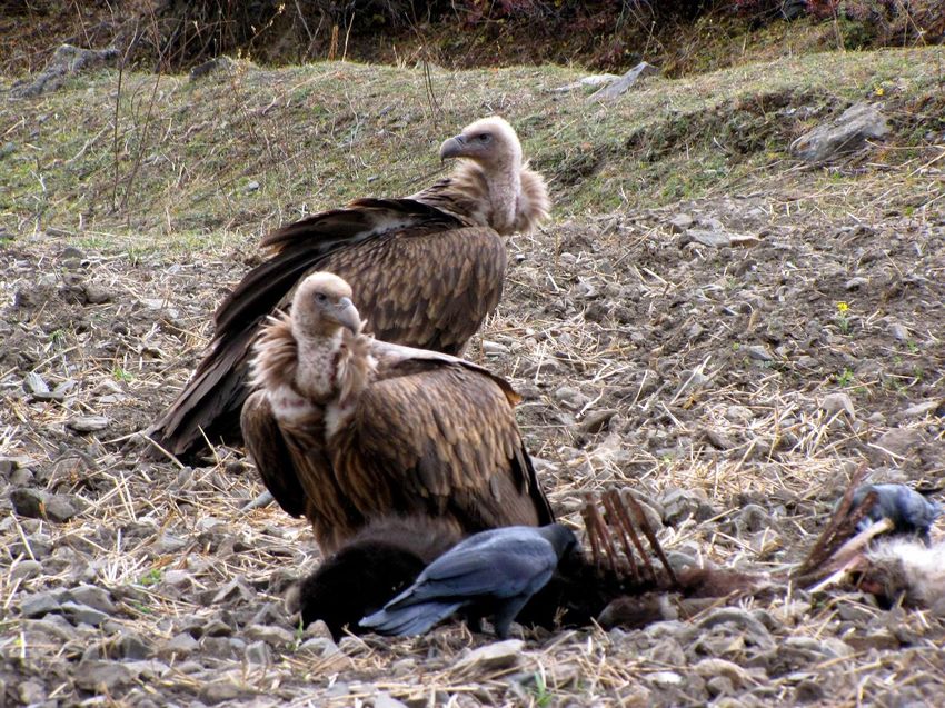
Qungmo Kangri 7048m northwest face seen from Xogu La

    Nyainqentanglha 7162m highest peak (left end) south face

3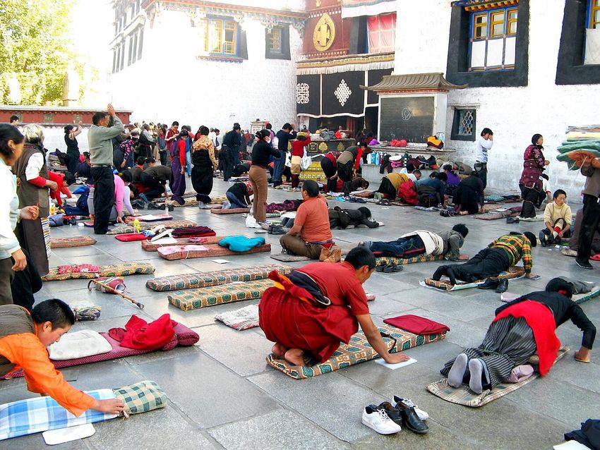
Nyainqentanglha 7162m (highest right end) west face

    Nyainqentanglha 7162m (right end) north face and Lake Nam Tso in November

4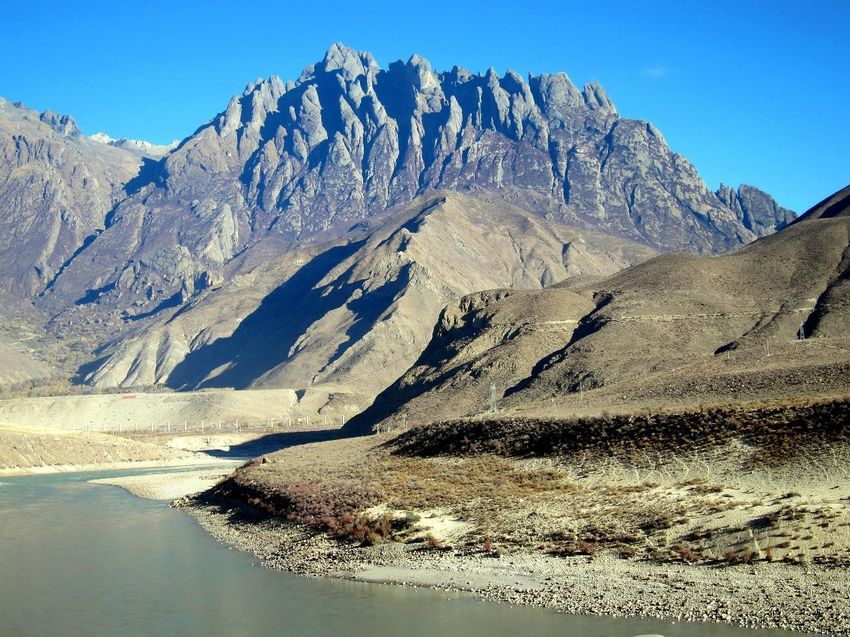
Golden Dragon 6614m, south face (above) southwest face (below)

5
Kyizi 6202m east face viewed from Qinghai-Tibet Highway

    Samdain Kangsang 6590m east face viewed from Qinghai-Tibet Highway

6
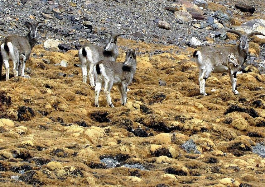
A group of blue sheep in Nyainqentanglha West

    A blue sheep                               A vulture

7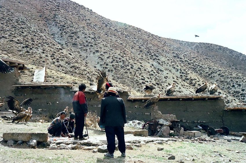
Lhasa Today – Potala Palace, Jokhang Temple and Shopping Malls

8
Jokhang Temple (above), Street in back of Jokhang Temple (below), Lhasa

9
j

10
Lhasa ('Place of Gods') is the urban center of the prefecture-level Lhasa City and the
administrative capital of the Tibet Autonomous Region (TAR). The inner urban area of Lhasa
City is equivalent to the administrative borders of Chengguan District, which is part of the
wider prefectural Lhasa City.
Lhasa is the second most populous urban area on the Tibetan Plateau after Xining and, at an
altitude of 3,656 meters (11,990 ft), Lhasa is one of the highest cities in the world. The city
has been the religious and administrative capital of Tibet since the mid-17th century. It
contains many culturally significant Tibetan Buddhist sites such as the Potala Palace, Jokhang
Temple and Norbulingka Palaces.
Lhasa is now undergoing a drastic transformation. Population has become more than double
from 300,000 to 700,000 and has been changed to a modern city. Symbol, Potala Palace is
beautifully lighted-up, Shopping malls and department stores are the same as those of Hong
Kong. New office buildings and multistorey residential apartments are being constructed
successively. Ring road surrounds the Lhasa city. Old towns are changing to modern and
active shopping zones where many Chinese and Tibetan are gathering. Devout Tibetan walk
clockwise around the Potala Palace.
Industry of Lhasa is now tourism. 95% of visitors are Han people coming from many provinces
of China. Arrival-Departure board of Lhasa Airport indicates China’s major cities.

11
My friend, a Tibetan guide Unless I knew a Tibetan guide, Awang (Kedup Geltsen), my odyssey was not so successful. Awang is now 43 years old. He was born in a beautiful lake side of Yamdrok Tso where brilliant Noijingkangsang 7191m below and Kaluxung 6646m (next page) are dominating. 12
13
Kaluxung 6647m (right) and Lake Yamdrok Tso

As his family was poor, after graduating a primary school, he was enrolled to a training school
of Buddhism and chose his life to serve as a monk. However, when six years passed, he gave
up a course to serve as a monk and entered an English learning night school. Then he became
a tourist guide for foreigners. Now he is an excellent English-speaking guide who studied by
himself. His talent is not only language but also a good sense to gather necessary information.
As he served as a monk, he has school mates in monasteries of many places in Tibet and has
friends of Public Security Bureaus. This helps him to make persistent negotiation with officers.
Unless I met him, my odyssey to the Tibetan borderlands was not successful.

            Awang’s shop in Lhasa                  Nakamura, Awang and Awang’s wife

14
Awang currently reported to me “According to recently reported news, it says the construction period of the Sichuan-Tibet Railway will exceed 10 years. The Lhasa-Nyingchi section is expected to open and operate at the end of 2021, so it will be open at the end of this year or beginning of next year for latest. He took us a formidable skull wall in Damu Monastery (below) in the upper Salween River and sky burial place at Lhorong is shown in the next page. 15
Sky burial yard at Lhorong, eastern Tibet

16
Vultures coming to sky burial yard

17
Tree Burial in Drawalong Valley south of Bomi town

18
19
A starting place of the journey was Nyainchi of Bayizhen, which is the 4th largest city in Tibet
and strategic location of Tibet Military Section of China People’s Liberation Army.

                        Whole view of developing Bayizhen twon
20
Nyainchi Nature Museum Tight and Strict Watching In the year of 2008 when the Olympic was held at Beijing, terrible turmoil took place in a large scale. After the incident, control-restriction by the authorities over foreigners for approaching to south and southeast Tibet has become tighter and more strict year by year. To obtain permits from five departments has been compulsory; say, Public Security Bureau, Tibet Military Section of China People’s Liberation Army, Border Administration Office to check foreigners, Tourism Department of Tibet Autonomous Region, and authorized travel agency in Lhasa. Foreigners must carry these permits with them for travelling. Every check post inspects the permits all the way of moving from place to place. We met only two Canadians between Rawu and Bayizhen, whilst many Chinese tourists were rushing, but they moved only along trunk roads and did not enter unfrequented places off-the beaten tracks. Noisy Chinese tourists come in summer and behave in crowds. Many hotels have been constructed to accommodate them. Infrastructure is being improved successively. Construction of highways is being accelerated. Sichuan-Tibet Highway is paved, and express ways are being constructed. Railway from Lhasa 21
to Bayizhen along the Yarlung Tsangpo is supposed to have already been completed. The
railway is planned to be extended to Chengdu in future.

Pillars for railway from Lhasa to Bayizhen under construction (2016) along Yarlung Tsanpo

22
23
24
Dams are being constructed in Yarlung Tsangpo between Lhasa and Bayizhen

To Bomi, Midoi then Rawu

Most perilous part of the Sichuan-Tibet Highway (south route) landslide zone between Bomi
and Tamgmai is now by-passed through a new tunnel of 6 km and vehicles may pass safely
and quickly. After the tunnel, passengers soon arrive at old and elegant town, Guxung. South
face of stunning 6,000m peak soars dominantly looking down the highway. The road passes
along the Parlung Tsangpo which flows between Nyainqentanglha East of 750 km and Kangri
Garpo Range of 270 km in length from northwest to southeast.

I came to Bomi at 2,750m after 10 years. The township is modernized here too. Inhabitants
of Bomi area is mainly Khamba but Kongbo tribe live around Gompogyamda. Autumn colors
of the Parlung Tsanpo are beautiful. We entered the Midoi Glacier and then arrived at Rawu
at 3,960m for revisiting the destination of our journey to the Lhagu Glacier of Kangri Garpo
East. The Midoi Glacier is now one of famous touristic spots crowded with noisy Chinese.
Rawu has been reborn to a new town. We rested at an elegant hotel.

25
Modern street of Bomi Town

     Gutonchalagebo 5511m west face immediate north of Bomi township, Botoi Tsangpo

26
Tourism Center for entering Midoi Glacie. Parlung Tsangpo 27
Gemsong 6525m north face viewed from Parlung Tsangpo

     Gemsong 6525m north face and glacier terminus of Midoi Glacier, Midoi Longba

28
Global Warming―Receding of Glacier
I first visited Rawu in 1995. The Lhagu Glacier receded drastically. Retreat of glaciers is
eminent throughout in Tibet. According to Mauri Belt, an environment scientist, the Lhagu
Glacier receded by 12 km after 2001. This is witnessed by local Tibetan inhabitants.
Photographs of the Lhagu Glacier in 1999, 2006 and 2019 are shown for comparison.
Lhagu Glacier in 1999
29Lhagu Glacier 1999 30
Lhagu Glacier 2006

31
Lhagu Glacier 2006

     Lhagu Glacier 2006

32
Lhagu Glacier middle stream and Pk 6002m 2006
Hamokongga 6260m south face in the eastern bank of Lhagu Glacier 2006
33Lhagu Glacier 2019 (above and below) 34
35
Ca. 5400m breathtakingly beautiful peak in the middle steam of Lhagu Glacier

               Dejitsengza 5662 east face immediate north of Rawu town

36
Labelled Panorama of Kangri Garpo Range 37
Renewed Historical Shuguden Gompa near Rawu

38
To Dema La, Gateway to Forbidden Zayul

(above) Pk 6000m (below) Gheni 61 50m north face seen from a road to Dema La 4900m

39
Yuhe Kangri 6327m north face in the back viewed from a road to Dema La pass

              Dema La pass 4900m, a gateway to forbidden Zayul

40
Yuhe Kangri 6327m east face seen from Guyu village in Zayul River basin Tiba Kangri 6846m southwest face west of Gyala Peri seen from Sichuan-Tibet Highway 41
Map of Easternmost Himalaya – Namcha Barwa and Gyala Peri massifs, photos in next page

42
On the Return Way to Lhasa

Gyala Peri 7294m north face viewed from Tangmai, confluence of Yi’ong/Parlung Tsangpo

  Namcha Barwa 7782m west face seen from Se-Ti La 4500m on Sichuan-Tibet Highway

43
Meila Shan~Lhasa, Tibetan Mastiff (above) Group of Yaks (below) in snowing

44
You can also read