Beyond Lake Villages in the Neolithic of Austria
←
→
Page content transcription
If your browser does not render page correctly, please read the page content below
P AST
THE NEWSLETTER OF THE PREHISTORIC SOCIETY
Registered Office: University College London, Institute of Archaeology, 31–34 Gordon Square, London WC1H 0PY
Beyond Lake Villages in the Neolithic of Austria
Waterlogged archaeological sites offer exceptional insights
http://www.prehistoricsociety.org/
been limited. The conferral of World Heritage status was
into prehistoric life. Excellent preservation conditions for an important impetus to the development of a network of
most organic materials enable archaeological research to national and federal institutions (including the University
deploy its full interdisciplinary arsenal and gain a deeper of Vienna, the UNESCO World Heritage Management
understanding of socio-economic and ecological conditions. Association ‘Kuratorium Pfahlbauten’, the University of
The waterlogged sites on the shores of the Alpine lakes and Innsbruck, the Upper Austrian State Museum and the
in the wetlands of the perialpine zone are among the most Natural History Museum Vienna) which have begun several
famous and evocative. Currently, about a thousand sites collaborative projects to address these shortcomings.
dating to the time span 5000–500 BC are known from
around the Alps. In 2011 UNESCO World Heritage status
was accorded to 111 of them, spread across six different Excavating the hilltops
modern nation states. Since 2014, the University of Vienna and the Ludwig
Boltzmann Institute for Archaeological Prospection and
Nearly 30 waterlogged lacustrine sites are known from Austria. Virtual Archaeology (LBI ArchPro) have been conducting
Most are scattered around the northern Alpine lakes of Upper archaeological fieldwork around lakes Attersee and Mondsee.
Austria (Attersee, Mondsee, Traunsee), with two south of the The aim is to investigate settlement history and land use in
Alpine range (Keutschacher See, Hafnersee). Chronologically, the hinterlands of the lakes within a diachronic perspective.
they fall within a broad time span from approximately 4200 One major success of our excavation campaigns was the
to 500 BC. The most important group are the 23 sites in discovery of a hilltop settlement dating to the 4th and
Upper Austria, most of which are associated with the early 3rd millennium BC just north of Lake Attersee at
archaeological cultural entity known as the Mondsee Group Lenzing. For the first time in Austria, we have knowledge of
(4th millennium BC). It is known for its distinctive, white a hinterland settlement contemporaneous with the lakeshore
encrusted ceramics and early rich evidence for copper casting. sites. Excavations are currently taking place on the fortified
multi-period hilltop site of Buchberg-am-Attersee, whose
The Austrian sites were discovered shortly after those in main phase appears to extend from the Middle Bronze Age
Switzerland, but modern transdisciplinary research has to the Iron Age. Earlier phases are expected.
View over Lake Attersee. © K. Kowarik
Number 85 Spring 2017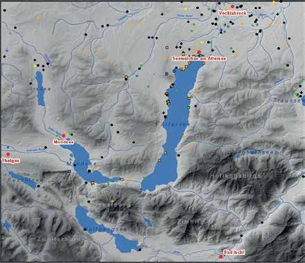
Going Beyond Lake Villages
                                                                    The Beyond Lake Villages project (jointly funded by the
                                                                    Swiss, German and Austrian national funding agencies,
                                                                    SNF, DFG and FWF, see also https://beyondlakevillages.
                                                                    wordpress.com/news/) focuses on the 4th millennium BC
                                                                    as a time of fundamental change in Europe’s early agrarian
                                                                    societies, while also considering developments in a broader
                                                                    time frame. Since 2015, an international team has been
                                                                    establishing a highly resolved Holocene palaeoenvironmental
Typical Mondsee pot                                                 record, enhancing our understanding of landscape in terms
© Museum Mondsee /                                                  of spatial networks, and integrating palaeoenvironmental
OÖLM                                                                data sets with archaeological data in three research areas:
                                                                    the Bernese Swiss Plateau; Lake Constance and the Federsee
Excavating underwater                                               region in southern Germany; and Attersee and Mondsee.
The underwater sites in the lakes Attersee, Mondsee,
Keutschacher See and Hafnersee have been subjected to               The investigation of sedimentary archives is a central aspect of
repeated underwater survey in recent decades. In 2015,              our work. We focus on climatic and anthropogenic impacts
the Federal State of Upper Austria (which has scheduled             on past ecosystems, as well as on prehistoric agricultural
a major exhibition on lakeshore settlements for 2020)               systems and subsistence strategies, through reconstructing past
and Kuratorium Pfahlbauten initiated a five-year research           forest use and tree/shrub diversity and regeneration cycles.
programme (the Zeitensprung project) that aims to gain              Different types of sedimentary archives have been targeted.
new insights into settlement structure and history, as well         In June 2016, a sediment core 14 m long was taken from
as human–environment interactions. It includes excavations          Lake Mondsee at a water depth of 64 m. The stratigraphy is
and an extensive interdisciplinary programme. As a pilot            currently being analysed for geological, sedimentological and
project, a part of the Seewalchen site at the northern end of       biological proxies. The first results from Mondsee suggest the
Lake Attersee has been excavated and was radiocarbon dated          use of fire c. 6000–5000 cal BP, associated with the earliest
to 3800–3500 cal BC, thus associating it with the Mondsee           pastoral activities and cultivation of cereals in the area, and
Group. Evidence for an older settlement phase (4200 BC)             coinciding with eutrophication of the lake (indicated by the
nearby was also found, and there are indications for human          presence of Tetraedron cf. minimum).
activity in the 7th millennium BC.
                                                                    Attention is also being paid to the analysis of lake sediments
Since 2016, the excavations have focused on another 4th             within archaeological contexts. Short (< 1m) stratigraphies,
millennium site, Weyregg II on the eastern shore of Lake            including cultural layers reflecting past human and livestock
Attersee, which is well protected by sediment and undisturbed.      activities, were recovered during the 2016 excavation of
The research history of lake villages in Austria means we           Weyregg II. Systematic palynological investigations are
lack stratigraphic context for the majority of Mondsee              currently under way, revealing possible short- and long-term
Group artefacts currently known; thus one of the aims of            sedimentary hiatuses before and after the establishment of
the Weyregg II excavation is to establish a highly resolved         the Neolithic village, which suggests low lake water levels;
stratigraphy of this multi-phase site. The new excavations          a strong presence of cereal remains, possibly hinting at very
will also provide typochronological information and will            local processing and food preparation; and fungal spore types
be complemented by archaeobotanical, archaeozoological,             that highlight the presence of extensive amounts of livestock/
sedimentological and palynological analysis.                        human faeces within the cultural layers.

                                                                    A landscape perspective
                                                                    One major goal is to understand land use at a landscape level.
                                                                    Land use in the direct vicinity of the lakeshore settlements
                                                                    has been intensively investigated, but much less attention
                                                                    has been paid to the broader landscape. We have conducted
                                                                    surveys using LiDAR and aerial photography, with a
                                                                    developing geophysics programme. These have allowed us
                                                                    to identify a range of potential archaeological features in the
                                                                    hinterland of the lakes. Three areas around lakes Mondsee
                                                                    and Attersee were chosen for field survey and geophysical
                                                                    prospection to enhance our understanding of the full range of
                                                                    surviving features and to assess preservation conditions. We
                                                                    are now using GIS methods such as cost surface calculations
                                                                    and viewshed analysis, but also looking at site location
Excavation under water at Lake Attersee, Seewalchen I. © H. Pohl,
                                                                    choices. A Master’s thesis is currently focused on building a
palafittes.                                                         predictive model for the lakeshore sites. This will be tested

2    P AST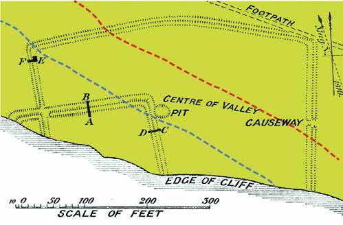
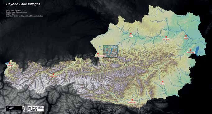
Location of Beyond Lake Villages research area
                                                                                (above) and location of currently known sites
                                                                                (left). Yellow: Neolithic; green: Bronze Age;
                                                                                blue: Iron Age; black: prehistoric (unspecified);
                                                                                dots signal unspecified sites, squares signal
                                                                                settlement sites, crosses are undated graves.
                                                                                © BELAVI

by underwater survey. A further Project, ‘OÖ ArchPro         the Attersee and other local councils, the University of
Pfahlbauten’, is currently getting under way to develop      Bern/Oeschger Center, the Landesamt für Denkmalpflege
the technology for extensive high-resolution underwater      Baden-Württemberg, LBI ArchPro, the Central Institute
archaeological prospection. We hope that taken together,     for Meteorology and Geodynamics (ZAMG), and the
these investigations will shed new light on the Neolithic    Universities of Vienna and Innsbruck.
of the Mondsee region and deepen our understanding of
human–environment interrelations in the 4th millennium       Kerstin Kowarik (University of Vienna; Kerstin.kowarik@
BC in the circumalpine area.                                 univie.ac.at), Jakob Maurer, Henrik Pohl, Cyril Dworsky,
                                                             Jutta Leskovar, Klaus Löcker, Helena Seidl da Fonseca, Julia
                                                             Klammer, Christoph Daxer, Michael Strasser, Marie-Claire Ries,
Acknowledgements                                             Benjamin Dietre, Jean Nicolas Haas (University of Innsbruck;
We would like to thank the following project partners: The   Jean-Nicolas.Haas@uibk.ac.at), Immo Trinks, Timothy
Federal State of Upper Austria, the Mayr-Melnhof estate,     Taylor (University of Vienna; Timothy.taylor@univie.ac.at)

                                                                                                               P AST          3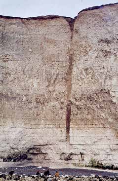
Well, well, well… getting to the bottom of the Belle Tout Shaft
Over a century ago a dished hollow had been noticed                at Arthur’s insistence, did take some souvenirs in the shape
nestling against the valley entrenchment at Belle Tout on          of wet, slimy, twisted or plaited twigs, a couple of pieces of
the Sussex cliffs near Beachy Head. In 1912, H.S. Toms             flat wood several inches square (waterlogged bucket staves or
identified it as a pit, and Richard Bradley recorded it during     bases?), some small twigs, some roundwood rods (c. 6 mm
his 1968–9 excavation at Belle Tout. Shortly after, a cliff fall   diameter) and a small jar of the odorous silt. Some of the
early in 1971 conveniently sectioned the feature, exposing         wood was later identified as hazel (Corylus), alder (Alnus)
a chalk-cut shaft about 43 m deep from the top of the cliff        and hawthorn (Crataegus).
and continuing into the chalk wave-cut platform. It was
a remarkable piece of engineering. Below the 10–12 m               What date was the shaft?
diameter weathering cone, it was vertical-sided, almost            Perhaps one of the most enigmatic problems is the date
perfectly circular, with a diameter of about 1.7 m only            of the shaft. Richard Bradley has suggested that a series
tapering about 9 m above the foot of the cliff. A series of        of footholes towards its base were possibly cut by a metal
foot holes and at least two types of tool mark were recorded.      pick and a metal blade. Later, a Middle Bronze Age body
Excavation in 1975 showed it to go at least 0.8 m into             sherd was found about 20 m down. However, there is no
the wave-cut platform and below a layer of festering and           reason why the shaft could not be Iron Age, Roman, Saxon,
stinking seaweed, beach cobbles and sand was a black, silty,       Medieval or even Post-medieval. It cut the southern valley
waterlogged deposit with some organic remains, including           entrenchment at Belle Tout, thought to be of Beaker date.
fibrous material, twigs and wood shards.                           The shaft remained exposed in the cliff for many years and
                                                                   finally collapsed c. 1984. Its base was buried by piles of chalk
The shaft was an attraction; and numerous notable local            rubble; later it was buried by metres of flint cobbles. And
archaeologists visited, took photographs, made their own           there it lay for three decades.
notes and have their own recollections … but no concerted
formal attempt was ever made to fully record, sample or            The significance of a potential prehistoric, Roman or later
excavate it in any way.                                            well base and all it could hold, including its accompanying
                                                                   palaeo-environmental record, was in danger of being lost.
What was the shaft?                                                So I decided to retrieve it. It now resided on the wave-cut
The function of the shaft is not immediately clear, but it         platform, probably between about 10 and 30 m from the
has strong parallels with the Bronze Age well at Wilsford,         current cliff line. Finding it, however, was a challenge: it
south of Stonehenge, which contained waterlogged oak               required repeated visits to a landscape constantly changed
bucket bases, alder bucket staves, rope and evidence of a          by tides and storms bringing in and stripping out cobbles
covering canopy. Certainly the bottom of the Belle Tout            and boulders. A series of local, energetic volunteers from the
shaft, virtually at the base of the cliff, was waterlogged; it     NT Seven Sisters Archaeology Project, CITiZANS project
was single-handedly part-excavated by the late Arthur Sayers       and South Downs Research Group were unleashed to search
and about 1 m in diameter. A bucket of salty, waterlogged          for it. If we could re-locate the base of the shaft, we could
silt sat in Arthur’s house for years. I shared the bedroom         explore its dark muddy secrets and provide a date, plus a
with it for nearly 9 weeks in 1980 when I lodged there and,        regionally important palaeo-environmental record.

                                                                                                   Toms’ 1909 plan showing the
                                                                                                   ‘pit’ in the centre of the valley.
                                                                                                   Red line indicates approximate
                                                                                                   location of cliff in 2015, and
                                                                                                   blue line in 1968.

4    P AST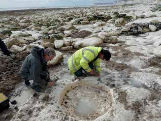
The Belle Tout shaft as exposed
                                                                                                 in the 1970s, with the shaft and
                                                                                                 its fill (left), and foot holes (right)
                                                                                                 (Photos: David Freke 1976).

Between October 2015 and February 2016, the band of                a stain on the base of the shaft, six other copper alloy and
volunteers searched and scoured the foreshore. After storm         one ferruginous stains were present. These are more likely
Imogen in February, the crew met success, finding an almost        to represent older objects lying against the sides and edges
perfectly circular feature filled with beach pebbles, now some     of the shaft and subsequently removed by the tide. They
15 m from the cliff. Their exhaustive searching had found          are currently being analysed by Dr Chris Carey (Brighton
the shaft. Part one done.                                          University). A number of tool marks were cast in dental
                                                                   alginate and are being studied by Martin Bell.
To excavate this was potentially difficult (tides) and very
costly, and would be inappropriate without a full research
design, specialist team and full funding. Our next step,           The valley entrenchments
therefore, was to lift off recent pebbles, expose the precious     Although the shaft itself is now gone, the area still warrants
archaeological deposits, plan them and auger the shaft base        further examination, as two sub-rectangular enclosures
to give an idea of the extent of the deposits and potential        are sited in the shallow dry valley. Although the larger,
goodies they might contain. A limited number of volunteers         northern enclosure (c. 64 × 37 m) overlies the southern
were enlisted, and Prof Martin Bell joined us from Reading         one, both have generally been considered to belong to the
to help. The team carefully exposed the shaft, removed the         same archaeological period. Toms’ excavations in 1909
modern beach pebbles… and found the base of the fully              trenched both enclosures and indicated the northern at
scoured-out shaft at only 20 cm depth – we were too late!          least to be Beaker. However, David McOmish has suggested
Apart from modern debris including a 19th–20th century             that the enclosures may be medieval in date. While both
washer or rove and a .303 cartridge case, which had not left       entrenchments are subrectangular and sited in the valley

Above: The team discover the infilled shaft in April 2016.
Right: Martin Bell and Mike Allen recording the excavated shaft.

                                                                                                                     P AST            5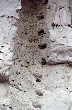
bottom, they are distinctly different in size, shape and Although the southern rectilinear valley entrenchment has
construction…. and, therefore, presumably date? The been entirely lost to cliff fall, the shaft did cut the enclosure
southern enclosure has straight sides marked by a bank ditch. A radiocarbon date from the base of the shaft will
and external ditch, the northern one, excavated by CG therefore not only date the shaft, but also provide a firm tpq
Archaeology last summer, has an internal ditch and one for the lost enclosure. The Prehistoric Society has contributed
distinctly bent or kinked side – clearly, it is a different type significant towards 14C dating (results pending) and working
of field monument. So are they really both of the same on the archive. Watch this space.
archaeological period?
Mike Allen, Allen Environmental Archaeology &
Bournemouth University (aea@themolluscs.com)
What killed the Neanderthals? Understanding environmental change
during the Middle to Upper Palaeolithic transition in northern Spain
The extinction of the Neanderthals and their subsequent sites in parts of Europe further afield, and other methods
replacement by Anatomically Modern Humans (AMH) must be sought.
during the Middle–Upper Palaeolithic transition (c. 40,000
years ago) shaped the course of evolution forever. Neanderthals Environmental proxies such as pollen, microfaunal remains
are the close relatives of AMH, and their demise enabled the and sediments can inform on past ecological conditions, but
human race to develop and thrive. But why did Neanderthals when dealing with an archaeological record that is 40,000
become extinct? years old many of these indicators are not preserved, suffer
from taphonomic biases that can cause gaps in the record, or
A host of factors have been proposed, including dietary were not recovered at all during older excavations. Luckily,
differences between Neanderthals and AMH, technological stable isotope analysis of δ13C and δ15N from bone collagen
inefficiency of Neanderthals, imbalances in demography, of animal bones, which are routinely found, can also be used
competition between the species, cognitive differences, to understand past environments. The Cantabrian region is
declines in genetic diversity and environmental shifts. The an ideal test case.
extinction of the late Neanderthal populations coincides with
several global-scale changes in environment, including a series The Cantabrian region on the northern coast of Spain hosts
of warming and cooling events during the Middle–Upper many rich Middle and Upper Palaeolithic transitional cave
Palaeolithic transition, which may have been a contributing sites, including El Castillo, El Mirón, Labeko Koba and La
factor. Viña, among others. The region contains extensive evidence
of Neanderthal occupation, followed by AMH activity in
Identifying environmental change over these long timescales caves represented by stone and bone tools, animal bone
can be a challenge. On a broader scale, climatic trends have assemblages, etc. The region was clearly an important location
been identified from Greenland ice cores, where oxygen for both human species and represents a unique opportunity
isotopes have recorded changes in temperature over tens to understand the factors that contributed to Neanderthal
of thousands of years. However, while ice cores provide an extinction, and especially the localised environmental
indication of overarching changes they do not reflect the conditions they experienced.
localised conditions experienced by humans inhabiting cave
This research is part of a larger investigation undertaken
at the International Institute of Prehistoric Research in
Cantabria (IIIPC), University of Cantabria (for funding,
see Acknowledgements), exploring human responses to
environmental change during the Middle–Upper Palaeolithic
transition in the Cantabrian region and central Serbia, both
of which are refugia for late Neanderthal populations. The
research is an international collaboration with researchers in
Spain, the UK, Serbia, Germany and Canada.
One of the key aspects is to use bone collagen δ13C and
δ15N stable isotope analysis of hunted ungulate remains to
characterise past environments experienced when Neander
The mountainous Cantabrian region holds a wealth of Middle and thals, and subsequently AMH, occupied the sites. This is the
Upper Palaeolithic sites, making it an ideal region for understanding
the responses of late Neanderthals and AMH to environmental first time that this technique has been used on animals from
changes (Photo: J. Jones). this period and region.
6 P AST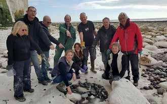
as cut marks from meat removal and fresh fractures from
marrow extraction, to ensure that all evidence of climatic and
environmental change can be directly correlated to periods
of human activity. By comparing the bones deposited during
different periods by Neanderthals and AMH it is possible to
determine how the environment changed in between these
Sampling animal
bones for analysis times. Specifically, the project is addressing the following
in the museum. questions:
Only a small piece
of bone (less than • How did the climate and environment in the Cantabrian
1 g) is required region change throughout the Middle–Upper Palaeolithic
(Photo: L. Agudo transition?
Pérez). • How did Neanderthals and AMH respond to the environ
mental changes?
Analysis of δ13C and δ15N in bone collagen is a technique • To what extent did climatic fluctuations contribute towards
developed in the 1980s to reconstruct past diets. The body the extinction of the Neanderthals?
uses carbon and nitrogen in the food we consume, leaving a
semi-permanent record of diet in bone tissue, which represents Initial results show that there were shifts in the environment
the last 10–15 years of life of a human (or almost the entire across the transition, with the climate becoming warmer
life of an animal). The technique tells us about foods that when AMH first appeared. A similar pattern was observed
were directly consumed by an individual (as opposed to in neighbouring south-west France at this time, suggesting
indirect indicators, such as animal bone assemblages). This that this might have been a trend experienced more widely
makes δ13C and δ15N analysis very valuable for exploring past in Europe. Results also suggest that in the eastern part of
diets. In humans the technique has been able to determine the Cantabrian region, animals within both Neanderthal and
that Neanderthals ate a more meat-rich diet, whereas AMH AMH cultural levels fall into two groups, one with higher
consumed a more diverse diet, including fish, plants and meat. and one with lower δ15N values. This could suggest that
animals were being hunted from distinctly different parts of
More recently, the technique has been used to investigate the landscape. Another interpretation is that this represents
animal diets. Plants growing in an environment take on climatic oscillations within these archaeological levels, and
varying amounts of δ13C and δ15N depending on the this possibility is being explored further as a hypothesis.
conditions they experience, such as how wet or cold the
environment is and the amount of tree cover, amongst In summary, there were climatic and environmental changes
others. Animals consuming these plants take on their isotopic across the Middle–Upper Palaeolithic transition. It is likely
signatures. Humans then hunt the animals as food and that whilst the climate played an important role in the
deposit the bones in archaeological sites. By analysing the extinction of the Neanderthals, it was one of a combination
δ13C and δ15N values in the bones it is possible to extrapolate of many factors. Further research is needed to explore changes
what the environment was like when these animals were in dietary behaviour in response to these environmental
alive. When used alongside more traditional environmental oscillations to investigate whether differing subsistence
proxies, the technique produces very powerful environmental strategies of Neanderthals and AMH played a role in the
reconstructions, directly related to the environment in the former's ultimate demise.
vicinity of human occupation sites at the time.
Acknowledgements
In the Cantabrian region, red deer are the species most This research has been supported by the European
commonly found on archaeological sites, allowing them to Commission through FP7-PEOPLE-2012-CIG (322112),
be consistently compared between chronological periods. We by the Spanish Ministry of Economy and Competitiveness
use bones with evidence of anthropogenic alteration, such (HAR2012-33956) and University of Cantabria grants
awarded to Dr. Ana B. Marín-Arroyo. ABMA has a contract
of the Ramón y Cajal Research Program (RYC-2011-00695)
and JJ is funded by a Marie Skłodowska-Curie individual
fellowship. The analytical research was undertaken at
the Max Planck Institute for Evolutionary Anthropology
and is funded by the Max Planck Society. Many thanks
to the Museum of Prehistory in Cantabria (MUPAC),
the University of Oviedo and the Centro de Patrimonio
Cultural Mueble de Gipuzkoa (Gordailua) in Guipúzcoa
for facilitating the sampling of animal bones.
Jennifer R. Jones (jonesjr@unican.es) and Ana B.
Marín-Arroyo, Instituto Internacional de Investigaciones
Small bone pieces demineralising in acid, part of the process to Prehistóricas de Cantabria (IIIPC), Universidad de
extract collagen from the bones to analyse for carbon and nitrogen
stable isotopes (Photo: J. Jones).
Cantabria
P AST 7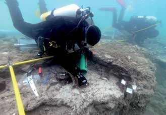
Notice of the 2017 (for 2016) Annual General Meeting
The AGM will be held on Saturday 24th June 2017 at                 The meeting will be followed at 5.00pm by the 26th Europa
4.25pm at the University of Southampton                            Lecture by Helle Vandkilde (University of Aarhus): ‘Small,
                                                                   medium, and large: Globalization perspectives on the Afro-
Agenda                                                             Eurasian Bronze Age’. The lecture will be followed by a
1. Minutes of the Annual General Meeting held at                   wine reception.
    Edinburgh University on 4th June 2016 (papers available
    from the website or from the Honorary Secretary)               Registered Office: University College London, Institute of
2. President’s report                                              Archaeology, 31–34 Gordon Square, London WC1H 0PY.
3. Secretary’s report
4. Editor’s report and R. M. Baguley Award                         Notes
5. Treasurer’s report                                              1. A member entitled to vote at the meeting may appoint a
6. Subscriptions                                                      proxy to attend and, on a poll, vote in his or her stead.
7. Report on meetings, study tours and research days                  A proxy must be a member, other than an institutional
8. Future composition of Council                                      member.
9. Awards                                                          2. To be valid, an instrument of proxy (together with
    – Collections Study Award                                         any authority under which it is signed or a copy of the
    – John and Bryony Coles Award                                     authority certified notarily or in some other way approved
    – Research Grants (Bob Smith Award and Leslie                     by Council) must be deposited with the Secretary, The
       Grinsell Award)                                                Prehistoric Society, c/o Department of Britain, Europe
    – Conference Fund                                                 & Prehistory, The British Museum, Great Russell Street,
10. Election of Officers and Members of Council                       London WC1B 3DG, by 4.30pm on the 13th May 2016.
                                                                   3. Forms of proxy may be obtained from the Secretary at
                                                                      the above address.

                                      The Prehistoric Society 2016
This report covers the period of January to December 2016.         Undergraduate dissertation prize (also covered in this issue
                                                                   of PAST). The Society’s springtime one-day conference (the
Meetings and study tours                                           first in a series exploring new directions in the landscapes
The Society has continued to fulfil its commitment to reach        of prehistory) focused on ‘The land, the sea and the sky’. A
a wide range of regional audiences and to promote its aims         report on the conference, held at the Society of Antiquaries,
and objectives through a varied and wide range of lectures,        can be found in PAST 83.
conferences and tours throughout Britain. The Society’s
events continue to represent collaborations with a number          In October a very successful joint conference with the
of other archaeological bodies and societies. In January joint     Royal Archaeological Institute was held in Carlisle on ‘The
lectures were given with The Society of Antiquaries and the        Neolithic of Northern England’. Another impressive range
Devon Archaeology Society. Alex Gibson (University of              of tours to sites and excavations were offered, including trips
Bradford and President of the Prehistoric Society) talked on       to Must Farm in February, led by Mark Knight, the Vale
the ‘The Bronze Age Neolithic: the reinvention of tradition’ in    of Pewsey in July, led by Jim Leary, and the ‘People of the
Edinburgh and Aberdeen. Jim Leary talked on ‘Recent work           Heath’ excavations in Petersfield (Hampshire) in September,
in the Vale of Pewsey’ in Exeter. In April, Peter Boyer gave a     led by Stuart Needham.
joint lecture with the London and Middlesex Archaeological
Society on the topic of ‘Neolithic ditches, Middle and             Europa Prize
Late Bronze Age enclosures at West Drayton’. In October,           Professor Peter Wells (University of Minnesota) was the 2016
Anwen Cooper delivered a joint lecture with the Norfolk            recipient of the Europa Prize. This year’s Europa was based
Archaeology Society on ‘Round barrow relationships:                around the theme ‘Dynamics of art, design and vision in
considering the role of round barrows in English landscapes        Iron Age Europe’, and was held at University of Edinburgh
from 1500 BC–AD 1086’.                                             on the 3rd and 4th of June 2016. The Europa Lecture was
                                                                   preceded by a day conference of lectures largely given by
In October, Ben Elliot delivered the 15th Sara Champion            new researchers. The following day’s lectures were delivered
lecture at the Society of Antiquaries, discussing ‘Antlerworking   by speakers invited by the Europa prize winner and the
practices of the British Mesolithic: materials, identities and     President of the Society. The Society’s AGM followed (see
technologies within the landscape’. For the fifth year this was    below) and the day culminated in the presentation of the
successfully combined with the presentation of the Society’s       Europa award to Prof Wells and his Europa lecture, ‘Design

8    P AST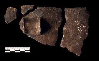
for communication in the Iron Age’. A review of the Europa          The Baguley Award
prize conference appeared in PAST 84.                               The Baguley Award was presented to Christopher Standish,
                                                                    Bruno Dhuime, Chris Hawkesworth and Alistair Pike for
Research Grants                                                     their paper ‘A non-local source of Irish Chalcolithic and
Research grants were awarded to M. Davis (Experimental              Early Bronze Age gold’ in Volume 81 of the Proceedings.
Iron Age glass making), M. Díaz-Guardamino (Iberian
Palaeolithic Art), M. Edmonds (Digitising the Mike Pitts            Undergraduate Dissertation Prize
archive), R. Loveday (Geophysical survey in the Midlands            As in previous years, each University department was invited to
and East Anglia), R. Madgwick (Bone analysis at Navan               submit only one dissertation for the Society’s Undergraduate
Fort, Northern Ireland), M. Parker Pearson (excavation of           Dissertation Prize. The winner was Amy Walsh (Royal
a geophysical anomaly at Durrington Walls), R. Williamson           Holloway, University of London). The three runners up
(for materials, moulding and casting costs for making               were Rory Connolly (Institute of Technology, Sligo), Aran
experimental Bronze Age Sussex loops), and G. Longhitano            McMahon (University of Cambridge) and Alex Alexander
(for textile tools research in Copenhagen).                         (University of Glasgow). Commended dissertations were
                                                                    submitted by Alicia Nunez-Garcia (Edinburgh University);
The John and Bryony Coles Award went to N. Sutton for               Fergus Hooper (UCL) and Christopher Scott (University
excavations in Papua New Guinea, the Bob Smith Prize to             of Sheffield).The awards were made after the Sara Champion
R. Madgwick, and the James Dyer Prize to R. Williamson.             lecture on the 26th October 2016, at the Society of
The SUERC Award went to K. Cleary (Knowth passage                   Antiquaries.
tomb; two dates) and A. Jones (Making a mark: Neolithic
objects; one date). The Leslie Grinsell Prize went to Roy           Publications
Loveday. The newly created Collections Study Award went to
D. Cansfield (Brighton & Hove Prehistoric Peoples research          During 2016, the Society published Volume 82 of the
project). An award from the conference fund was made to             Proceedings of the Prehistoric Society, which contained 13
M. Palmero Fernandez to attend the International Congress           refereed papers covering a range of topics spanning the
on the Archaeology of Ancient Near East.                            Neolithic to the Iron Age in Britain, Ireland, continental
                                                                    Europe and the Near East. As usual, three editions of PAST,
                                                                    the Society’s newsletter, were published during the year.
The Annual General Meeting for 2015/16
The AGM was held on Saturday 4th June 2016 at 4.25pm                Advocacy
in Edinburgh University, after the 25th Europa Conference
and immediately before the Europa Lecture.                          The Society continued its active role in advocacy in relation
                                                                    to the New Neighbourhood Planning and Infrastructure Bill,
The President reported on a very busy, yet successful year,         continuing concerns regarding the proposed developments
providing details of the Society’s core activities, publications,   at Old Oswestry Hillfort, concerns regarding finds from
excursions, lectures and conferences. It was noted that             Banks chambered cairn on South Ronaldsay, Orkney, and
subscription rates may need to increase in coming years             Canteen Kopje, a Palaeolithic site in South Africa threatened
with due notice to be given to members. The President then          by mining operations. The Society continued in its attempts
thanked all Council and members who have assisted with a            to support the inclusion of prehistory in the primary school’s
range of events during the year. Warm thanks were offered           National Curriculum by pursuing the goal of including
to retiring Officers and Council members Anwen Cooper               a range of free and trusted teaching resources relating to
and Jacqueline Nowakowski. Reports were also given by the           prehistory and prehistoric sites on the Society website and
Secretary, Managing Editor and Treasurer. The following             in providing assistance to teachers.
officers and members of Council were then elected:
                                                                    Membership and administration
 President                                Dr Alex Gibson            Membership of the Society is healthy and continues to rise.
 Vice-President                           Dr Roy Loveday            The Society’s online and social media presence (on Facebook
 Treasurer                                Dr Clare Randall          and Twitter) has also developed considerably in the last year,
                                                                    with 2300 followers on Twitter and 8500 on Facebook.
 Secretary                                Dr Neil Wilkin
 Managing Editor/Editor of PPS            Dr Julie Gardiner         As ever, the Society would not be able to function without
 Editor PAST                              Dr Daniela Hofmann        a large number of individuals giving freely of their time
 Editor, Prehistoric Society Research     Dr Mike Allen             and knowledge to organise events and to deliver the results
  Papers Series                                                     of their fieldwork and research. The Society offers sincere
                                                                    thanks to all those who have helped throughout the year,
 Book Reviews Editor                      Ms Pippa Bradley
                                                                    and especially to its administrator, Tessa Machling.
 Meetings Secretary                       Dr Marcus Brittain
 Conservation CoOrdinator                 Dr Jane Siddell
 Council                                  Dr Andy M. Jones
                                          Dr Elizabeth Walker

                                                                                                                   P AST         9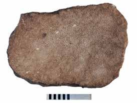
The 3rd Neolithic and Early Bronze Age Research
Student Symposium
The 3rd annual Neolithic and Early Bronze Age Research construction and labour, including papers on the origins of
Student Symposium (NEBARSS) took place on the 18th and the sarsen stones at Stonehenge (Katy Whitaker, University
19th of November 2016 at the UCL Institute of Archaeology of Reading), the construction of communities through
in London. Speakers discussed a broad range of archaeological long barrow building, reviewed through assemblage theory
research into the Neolithic and Early Bronze Age periods and (Mareike Ahlers, Newcastle University) and a review of
the event provided a platform for postgraduate, independent Renfrew’s (in)famous chiefdom hypothesis in light of
and early career researchers to present their work in an additional labour estimates for monument construction in
informal environment. The symposium was organised by Wessex (Barney Harris, UCL).
UCL PhD students Barney Harris and Robert Kaleta and
was kindly sponsored by the Prehistoric Society and the UCL The third session included talks on the significance of
Joint Faculty Institute of Graduate Studies. categorising artefacts, using the Unstan Bowl as a case
study (Michael Copper, University of Bradford), farming
The theme of the 2016 symposium was ‘Anarchy in the UK?’, and ceramic production in Anatolia (Beatrijs De Groot,
a playful concept designed to challenge speakers to consider UCL) and highlighting the alleged absence of cremations in
how their work contributes to understanding social change the British Chalcolithic (Anna Bloxam, UCL). The fourth
in prehistory beyond linear, evolutionary narratives of in and final session focused on emerging digital platforms for
creasing hierarchical control. The theme also highlighted the engaging the public in archaeological sites and centred on
importance of revolutionary shifts within archaeological theory. a current project at C̹atalhöyük, Turkey (Tara Copplestone,
University of York and Izzy Bartley, University of Aarhus)
The conference commenced on the evening of Friday 18th and the reoccurring colours red, black and white in the
with a keynote lecture from UCL’s Mike Parker Pearson. Neolithic megalithic monuments of Atlantic Europe (Penelope
His presentation, ‘Back to the future: contemporary issues Foreman, Bournemouth University). It concluded with a
in British later prehistory’, highlighted an emerging new second keynote lecture from Joanna Brück (University of
scientific turn in archaeology, based on Big Data, quantitative Bristol) on mortuary practices and social evolution in Early
modelling, materiality studies, ancient DNA and isotope and Middle Bronze Age Britain, with a critical re-evaluation
analyses. His own research on the genetics of Neolithic Bell of the Amesbury Archer and the Boscombe Bowmen burials.
Beaker communities demonstrated the potential for new
analytical technologies to contribute to research questions The symposium created a relaxed atmosphere for new
framed by post-processual archaeological theory. The lecture researchers to gain experience in presentation, promote
was followed by questions and a wine reception. current research and gain valuable insights from other
academics, as well as providing a highly captivating day of
On Saturday the 19th the first session included new research archaeological research for the audience. The environment
on challenging the connotations of animal domesticity (Emily was positive and encouraging form all guests, volunteers,
Banfield, University of Leicester), visualisation of Neolithic speakers and professors, and we look forward to next year’s
domestic dwellings in the Milfield Basin (Seren Griffiths, symposium hosted at UCLAN.
University of Central Lancashire) and domestication of the
Neolithic and Bronze Age mind (Alexander Aston, University A selection of the presentations from the conference are
of Oxford). The second session centred on monumental available online at nebarss.wordpress.com
Barney Harris, Dannielle Croucher and Hayden McKee,
University College London
The 15th Sara Champion Memorial Lecture, October 2016
Antler is a versatile and special material, used to make a
variety of artefacts, both utilitarian and decorative. Its natural
shedding and regrowth is seasonal and can be conceptually
linked to cycles of death and rebirth. In the 15th Sara
Champion lecture, titled ‘Antler working practices of the
British Mesolithic: Materials, identities, technologies within the
landscape’, Dr Ben Elliott of the University of York set out
to present the highlights and results of his PhD examining The President greeting
Ben Elliott at this year’s
Mesolithic antler artefacts, with the benefit of looking back leture. Photo: Marcus
at his research a few years after it was completed. Brittain.
10 P ASTStarting with a dataset of 105 sites from across Britain where hafting, be better described as axes. He argued that subtle
Mesolithic antler artefacts had been previously identified, changes in terminology can better align British descriptions
Dr Elliott explained to us how he soon realised that only of artefacts with Continental examples, allowing broader
16 of these sites had stratified deposits. Wary that some of comparisons to be made. For example, by linking T-axes
the artefacts may therefore not in fact be Mesolithic, he identified in Scotland to similar artefacts from the North Sea
reviewed the available AMS dates and showed that some basin, Dr Elliott raised interesting questions about the spread
object types such as uniserial barbed points (previously of ideas and technology in the early fifth millennium BC.
assumed to be Mesolithic based on comparisons with
Danish assemblages) actually span the Upper Palaeolithic In an impressive and articulate lecture, Dr Elliott demon
as well as parts of the Mesolithic, whereas base mattocks strated the value of careful and thoughtful research into
and maceheads are later prehistoric. In a reassessment of the prehistoric material culture. New discoveries and data
terminology used to describe antler artefacts and through are important, but fascinating insights can also be made
detailed examination of objects Dr Elliott also found that through the reassessment of objects awaiting rediscovery in
many so-called mattocks may, owing to the nature of their our museum stores.
Jody Joy, Museum of Archaeology and Anthropology, Cambridge
Prehistoric Society Undergraduate Dissertation Prize 2016
The awards to the winner and three runners-up for the Society’s
2016 Undergraduate Dissertation Prize were presented at the
Society of Antiquaries before the Sara Champion lecture on
the 26th of October. The overall winner of the prize was
Amy Walsh (Royal Holloway, University of London) for
her dissertation on ‘Developing a strategy to approach the
scientific investigation of Pleistocene deposits along the High
Speed Rail Two (HS2) route through Buckinghamshire’.
Amy received three years’ free membership of the Society,
her choice of one of the Society’s in-print monographs, a
cheque for £100 and the opportunity to submit an abridged
version of her dissertation for publication in the Proceedings. This year’s prize winners. From left to right, Alex Alexander, Amy
The three runners-up, each receiving a current copy of the Walsh, Rory Connolly and the President. Photo: Marcus Brittain.
Proceedings, were Rory Connolly (Institute of Technology,
Sligo) for his dissertation on ‘Morphometric characterization talon usage at Neanderthal sites as evidence for symbolic
of Patella vulgata shells: investigating variations in shell behaviour’; and Alex Alexander (Glasgow University) for
morphology from Late Mesolithic and Early Neolithic ‘Neolithic pottery from Dunning, Perthshire. Understanding
occupation levels at Fanore More, County Clare’; Aran Neolithic ceramic practice using a multi-disciplinary
McMahon (Cambridge University), who could unfortunately approach’. The judges of the prize were impressed with the
not attend in person, for ‘Clutching at claws? Assessing overall quality of the dissertations this year.
Prehistoric Society Undergraduate Dissertation Prize 2017
The Prehistoric Society invites submissions for the 2017 the Proceedings of the Prehistoric Society. An abridged version of
undergraduate dissertation prize. The award celebrates the the successful dissertation will be considered for publication
dissertation that has made the greatest contribution to the in the Proceedings. The Prize will be presented prior to the
study of prehistory in any part of the world. The Prize is Sara Champion lecture on the 25th of October 2017.
open to students from any University in Britain and Ireland.
Each Department is invited to submit one dissertation by a This prestigious prize represents an excellent opportunity
candidate who completes her or his degree during the 2016/17 for outstanding young scholars to have their work publicly
academic year. The judges will assess entries on the basis of recognised, in the magnificent setting of the Society of
the quality of work, the originality of the approach and the Antiquaries, Burlington House in Piccadilly. Entries for
degree to which the research advances our understanding of the current academic year are to be sent as PDF documents
prehistory. The final decision is at the discretion of the Society. by the host Department to Professor Bob Chapman at
r.w.chapman@reading.ac.uk, by Friday 21st July. Entries can
The winner will receive three years’ free membership of the only be accepted if accompanied by the email address, postal
Society, the choice of one of the Society’s in-print monographs address and contact phone number both for the candidates
and £100. Three runners-up will be awarded a current copy of and for their supervisors.
P AST 11Robin Hood’s Other Ball? A newly-discovered causewayed
enclosure at Larkhill, Wiltshire
Wessex Archaeology was commissioned by the consultancy
WYG on behalf of Defence Infrastructure Organisation to
carry out archaeological investigations ahead of development
for the Army Basing Programme. One phase of these
works, which collectively involve an ambitious project to
accommodate the 4000 additional Service personnel and
their families who will be based on and around Salisbury
Plain by 2019, required the total excavation of about 13 ha
to the east of Larkhill Camp.
The site, which is only a half mile north-west of Durrington
Walls and 1.8 miles north-east of Stonehenge, was previously
thought to be free of significant archaeological remains. Aerial photograph of the causewayed enclosure ditches under
excavation (Photo: Adam Stanford).
Evaluation trenching revealed a Wessex linear and other
ditches which were considered to be parts of Later Bronze
Age and Iron Age field systems, an undated unaccompanied individual episodes of cutting and recutting could be seen,
inhumation burial, a sub-rectangular Iron Age enclosure, with later cuts both deeper and shorter than the originals.
lynchets and terraces of probable Romano-British date, and
the extensive remains of military practice trench systems, The two easternmost ditch segments (to the right in the
predominantly from the First World War. photograph) were separated by an unusually wide causeway
of 13.5 metres, which may have been an entrance. Centrally
The results were of sufficient interest and in an area of within this gap was a shallow oval stepped pit containing
sufficient archaeological sensitivity for Wiltshire Council Early Neolithic pottery.
Archaeology Service to require full excavation of the area.
Stripping commenced in July 2016. Other ditch segments contained ceramics of varying types.
The primary fills contained fragments of bowls, most of
Among a host of interesting features, the most notable which were stylistically local, but which also included forms
prehistoric discovery was a series of seven ditch segments that were more typical of the South West. Other material
against the site’s southern boundary, forming 117 metres recovered from the excavated ditch segments included large
of an arc of a circle approximately 210 metres in diameter. quantities of flint debitage and some tools (arrowheads,
scrapers), animal bone (predominantly cattle), fragments of
The enclosure and its associated features represent a major a human skull and a large sarsen saddle quern. Fills higher
new discovery in the Stonehenge landscape. The excavated in the sequence contained small and abraded quantities of
part lies only 300 metres outside the northern boundary Grooved Ware and Beaker, and a complete Collared Urn
of the Stonehenge World Heritage Site. The causewayed had been placed into the almost completely silted segment
enclosure sits just below the brow of the low hill occupied at the western end. Cattle bone from the base of the ditch
by Larkhill Camp, commanding broad views to the north- was radiocarbon dated to 3780–3650 cal BC.
east across the valley of the river Avon towards Barrow
Clump and Sidbury. While most of the enclosure remains On the eastern side of the possible entrance, the partially
uninvestigated within Larkhill Camp, projections of its size silted ditch was cut through by a large posthole, one of a
suggest that its entire circuit lies on the northern side of the line of five on a roughly north-east–south-west alignment.
hill, therefore looking out across the Avon valley rather than
south and south-west towards Stonehenge.
Within the excavated area, only a single line of ditch segments
was encountered. While it may be possible that other circuits
of ditch exist inside the area defined by the excavated
segments, there are none without it, on the north side at
least. The projected diameter compares well with that of
Robin Hood’s Ball, 2.5 miles to the west-north-west, perhaps
suggesting that an inner ditch circuit could be expected.
The ditch segments varied in length, width and depth. Some
of these differences may have resulted from variations in the
chalk into which they are cut, but some of them seem to have Lugged pottery of South Western type from one of the ditch
been choices on the parts of the builders. In many segments, segments.
12 P ASTbarrows to its east and north-east, to the summit occupied
by the Knighton Long Barrow and the oval barrow south of
it adjacent to the Packway, and continuing on to end at the
scarp above Durrington Walls. The Larkhill enclosure sits
on a low eminence east of the Packway barrow and may be
the focal point around which it and the Knighton Barrow
cluster. Geophysical survey has revealed what may be the
remains of a further ploughed-down long barrow 600 metres
to the north, suggesting that further elements of the Early
Neolithic landscape await discovery.
Saddle quern from
one of the ditch Excavation is now complete, but post-excavation analysis
segments. remains to be undertaken.
Cattle bone from the posthole cutting the enclosure ditch
was radiocarbon dated to 2480–2290 cal BC. Acknowledgements
Excavations were undertaken by a team from Wessex
The Larkhill enclosure adds a very significant architectural Archaeology directed by Steve Thompson and managed by
element to the Early Neolithic Stonehenge landscape north Si Cleggett. Martin Brown managed the project for WYG
of the World Heritage Site. Known sites of this date are on behalf of Defence Infrastructure Organisation. Wessex
situated on the ridge of high ground running east of south- Archaeology would like to thank Adam Stanford of Aerial
east from Robin Hood’s Ball and the cluster of long and oval Cam for his work at very short notice.
Matt Leivers, Wessex Archaeology (m.leivers@wessexarch.co.uk)
Excavation of a large Bronze Age burnt mound complex on
a hilltop site in Suffolk
Between March and October 2016, Suffolk Archaeology c. 1 km from the valley bottom, where the geology was a
CIC excavated 10.6 hectares in the first phase of works in mixture of clay, gravel and chalk.
advance of residential development to the north-west of Bury
St Edmunds. The site lies on a north-facing slope on the south Within one of the natural hollows, in an area of clay geology,
side of the valley of the River Lark, overlooking the eastern a large ring of heat-altered flint over 20 m in diameter was
end of the Fornham Cursus (and associated monuments), uncovered, together with evidence of a cobbled surface.
a scheduled monument (SF114) which runs for 1.87 km Some three months later, and after the excavation of many
north-west to south-east along the base of the valley, on the tonnes of material, a complex of features including a series
south side of the river. A ditched square Roman enclosure was of large and smaller pits, huge dumps of heat-altered flint
sited at the top of the hill with good views in every direction within a charcoal matrix and a metalled surface bearing signs
across the surrounding countryside. Iron Age activity was of repair were revealed.
recorded across the whole excavated area, including over
100 circular pits concentrated at the north end of the site. The complex covered an area of 23 × 21 m in an irregular
However, the most enigmatic feature refers to occupation circular shape. A cobble surface (0.1–0.2 m thick) made
during the Late Neolithic/Early Bronze Age. Small hints up of flint and sandstone lay at the base, depressed into the
appeared that something unusual was present within the natural glacial deposits of sand and clay. This was overlain by
excavation area relating to this period, with numerous subsoil
and surface finds of worked flint throughout a large area.
I knew at this point that we were looking at something
exciting and very special given the location. The amount of
finds present spurred us to investigate the elevated area of
the site further, trying to find out what this activity related
to and what had occurred at this location in prehistory.
The geology is variable across the site and there was evidence
of successive campaigns of mineral extraction from the
Roman to the Post-medieval periods, as well as large
natural colluvium-filled hollows. Archaeological features
contemporary with the later use of the cursus complex were
primarily identified at the upper, southern part of the slope, Overview of the burnt mound hollow (Photo: Flypod).
P AST 13Left: Earlier circular
pit showing lenses of
water-borne deposits
(Photo: P. Boyles, Suffolk
Archaeology).
Right: Burnt mound
hollow and associated
pits 100% excavated,
taken with a pole camera
(Photo: T. Carter, Suffolk
Archaeology).
a layer of charcoal and heat-altered flint (0.2–0.4 m thick), In many ways, the site resembles other wells and burnt
which in turn was sealed by two natural silting layers (0.7 m mound complexes found on the fen edge (e.g. Bradley Fen
thick). The later layers of silting seen at the top of the feature in Cambridgeshire and Northwold, Norfolk), but its location
were cut by an Iron Age D-shaped enclosure. high above the valley is unusual. These are only preliminary
results, but it is hoped that analysis of environmental samples
The main hollow was excavated in quadrants, which were and other scientific techniques, as well as further research
subdivided into two-metre squares to maximise recovery of into parallels, will reveal more about the function of this
finds data. Once the layers covering the cobbled surface were feature. The working hypothesis is that organic materials,
excavated the true complexity of the feature could be seen. perhaps hides or wattle hurdles, were being processed, with
water being collected in the larger pits and heated within
Two large pits were located towards the centre of the hollow; the smaller pits. One of the smaller pits, which contained
the later oval pit measured 8 × 4 m and cut the cobbled two dumps of heat-altered flint on top of a greasy fill that
surface, whilst the other circular pit was 9 × 8 m and seemed seemed to have a high organic component, may hold the
to be earlier than or contemporary with it. These two pits key to the activities occurring within this complex.
contained complex fill sequences and would have held
water, shown both by the presence of water-borne deposits A droveway, probably also Bronze Age in date, was seen
and as experienced on site in wet weather. The later oval pit running from top to bottom of the slope, 130 m east of
had a clay lining on one side where it cut a seam of sand. the burnt mound complex, and pits containing Bronze Age
Three possible surface water run-off gullies led into theses pottery were dispersed across the southern part of the site.
pits. Six postholes (with five further possible ones) seemed This shows that the burnt mound complex was within an area
to surround the earlier circular pit. These postholes were of other Bronze Age activity and not just an isolated feature.
sealed by the cobbled surface and were only seen once it Further funded analysis on the mound is currently under
was removed, suggesting that in its earliest phase there may way, with residue analysis, soil micromorphology and finds
have been a structure around the top of the pit, perhaps to categorisation and dating planned in order to shed more light
aid its construction. Finds retrieved from these pits include on the processes that were occurring within this feature. In
Bronze Age pottery, flint and animal bone. the meantime, any suggestions are welcome.
Seventeen smaller pits of various sizes from 0.8 m to 2.5 m in Acknowledgements
diameter were located mostly around the edge of the hollow The author would like to thank Countryside for funding this
and all cut the cobbling. These contained deposits of heat- project and John Trehy (Terence O’ Rourke) for consulting,
altered flints and charcoal with finds of pottery and struck Dr Abby Antrobus (Suffolk County Council Archaeological
flint; one pit even yielded a large assemblage of decorated Service) for her input and monitoring of the project, Kasia
Beaker pottery and flint tools. Most notably, more than Gdaniec (Cambridgeshire Historic Environment Team),
249 flint scrapers have been found across the complex, with Alex Bliss (Suffolk County Council Archaeological Service)
most originating from the flint and charcoal layer above the and Edward Martin for information on burnt mounds and
cobbles, although many were also recovered from the pit fills Flypod and Tim Carter (SACIC) for aerial photography.
and within the surface.
Michael Green, Suffolk Archaeology CIC (Michael.Green@
suffolkarchaeology.co.uk)
Networks in the Linearbandkeramik
Gordon Childe once wrote of the Linearbandkeramik BC) brought farming from the Great Hungarian Plain to a
(hereafter LBK) that the ‘whole culture down to the finest vast area of central Europe. By approximately 5000 cal BC the
details remains identical from the Drave to the Baltic and culture stretched from the Paris Basin to western Ukraine and
from the Dniester to the Meuse’. The LBK (c. 5500–4900 cal is known for its impressive longhouse architecture and pottery
14 P ASTYou can also read