BIODIVERSITY IMPACT ASSESSMENT
←
→
Page content transcription
If your browser does not render page correctly, please read the page content below
BIODIVERSITY IMPACT ASSESSMENT

Project Description

The Indian Railways (IR) is the third largest railway network of over 64,000 route kilometre
has integrated markets and connected communities across the length and breadth of the
country. IR operates 12,000 passenger trains and 7,000 freight trains every day. It
transports 2.8 million tons of freight traffic and 30 million passengers every day. According
to Vision 2020 document of the Ministry of Railways, Government of India (2009) the
Indian Railways would strive to add 25,000 km of new lines by 2020, supported by
governments funding and a major increase in Public Private Partnerships (PPPs).
The Indian Railways is the lifeline of the nation and the economic growth is highly
dependent upon the Rail Transportation Capacity. Growth in economy leading to
surge in power, demand, booming infrastructure, construction and growing
international trade along existing Eastern and western Routes has led to the demand
for additional capacity for rail freight transportation.
The DFCCIL core objective is to create world-class rail infrastructure with advanced
technology to improve overall transport efficiency. To offer guaranteed, faster transit,
energy efficient, environment friendly transport to customers. To reduce the unit cost
of transport logistics. In the first phase, Government of India has approved
construction of two corridors – the Eastern DFC (1841 route Km) and Western DFC
(1500 route Km) – spanning a total length of about 3341 route Km. The Eastern
Corridor, starting from Dankuni in West Bengal is passing through the states West
Bengal, Jharkhand, Bihar, Uttar Pradesh and Haryana and terminate at Ludhiana in
Punjab. The Western Corridor will traverse the distance from Dadri in Uttar Pradesh
to Mumbai – Jawaharlal Nehru Port (JNPT), passing through the states of Delhi,
Haryana, Rajasthan, Gujarat and Maharashtra.
Once completed, the Dedicated Freight Corridor will enable Indian Railways to
improve its customer orientation and meet market needs more effectively. Creation of
Rail infrastructure on such a scale – unprecedented in independent India, is also
expected to drive the establishment of industrial corridors and logistic parks along its
alignment. The proposed corridor will provide safe, faster and economical mode of
transportation exclusively for goods.The proposed railway track is also strategic since
passing though the Left Wing Extremism districts. Dedicated Freight Corridor in the
Eastern Corridor is planned between Dankuni to Ludhiana to help cater to the freight on
this route. The section between Dankuni to Sonnagar is proposed to be implemented
through Public Private Partnership (PPP) mode for which appropriate PPP model is being
developed by DFCCIL .
The Total length of the section is 255.581 kilometres . Dankuni to Gomoh is an important
section of Delhi-Howrah double line electrified main trunk route of Indian Railway
connecting the Northern, Central and Eastern regions of the country. The proposed
alignment traverses on North side of existing Indian Railways(IR) track throughout the
section except for Koderma -Paharpur section where detour has been proposed.. Due to
the technical constraints construction of DFC track along the existing IR track in between
Koderma- Paharpur section is not feasible. Entire terrain is mostly plain terrain except hill
portion of Chota Nagpur ranges in Koderma detour. The proposed Koderma detour
section from km 123.600 to km 180.000 is a part of Eastern Corridor of the Dedicated
Freight Corridor Corporation Limited passing through Hazaribagh & Koderma district
in Jharkhand State and Gaya district in Bihar.
In Hazaribagh district the proposed alignment of Koderma detour starts at km
148.210, Village, Khairatanr and terminates at km 157.500, village Garmorwa under
Hazaribagh Wildlife Division, Hazaribagh . The proposed alignment from km km
148.210 to 149.000, 149.000 to 152.062, 152.062 to152.832, 153.100 to154.280 &
154.660 to 157.500 (Total 8.64 km, Area-82.8 ha) in Hazaribagh district falls under
Gautam Budha Widlife Sanctuary.
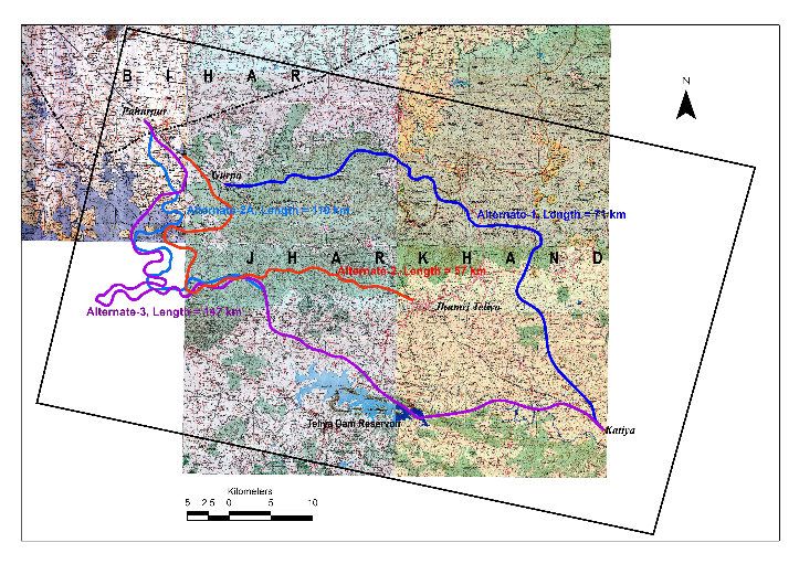
The Dedicated Freight Corridor Corporation alignment between Dankuni-Sonnagar
section runs parallel along the north side of Grand Chord section (Howrah-New Delhi
route).However in Koderma (Jharkhand)-Manpur (Bihar) Gaya section wherein the
existing gradients between Gurpa- Gujhandi sections are varying from 1 in 80 to 1 in
400 and therefore taking DFC line parallel to existing Grand Chord line with desired
gradient 1 in 200 is not possible. Hence it has been proposed to go on Detour
Alignment (Proposed Koderma Detour) with gradient of 1 in 200 and avoid Gurpa-
Gujhandi section.
Four detour alignments have been studied with gradient 1 in 200 and of varying
lengths on either side of Koderma-Manpur section. All the four studied alignment are
passing through the Gautam Budha Wildlife Sanctuary and Forest Area requiring prior
Wildlife Clearance and Forest Clearance from Ministry of Environment, Forest &
Climate Change.However due to serious gradient constraints on hilly terrain along the
existing Grand Chord section of Indian Railways track and other three alignments
were not found technically feasible.
Four villages (Khairatanr, Mainukhar, Bukar and Garmorwa) under the proposed
alignment are falling within Gautam Budha Wildlife Sanctuary notified vide S.O 1485
dated 14-09-1976.The construction of proposed alignment through the Gautam
Budha Wildlife Sanctuary would require 82.8 ha land in Hazaribagh district,
Jharkhand.
Alternate Alignment of Koderma Detour
Based on detailed study of surrounding, topography of the area and local
geographical features, best options were selected for the feasibility of running detours.
Four (4) routes or alignments were found to be the best for detours. Others routes
were found to be further longer with more length in Sanctuary area, involvement of
more forest area and cost of project increasing tremendously. All the four studied
alignments are passing through the Gautam Budha Wildlife Sanctuary requiring prior
Wildlife Clearance from MoEF&CC . However due to serious gradient constraints on
hilly terrain along the existing Grand Chord section of Indian Railways track and other
three alignments were not found technically feasible.
The construction of the proposed DFC alignments through the proposed Koderma
Detour is the only feasible and least obstructive option as far as the technical and
engineering aspects are concerned which requires the minimum Forest Land under
the proposed alignment. However attempts were made to minimize the impact in the
Wildlife Sanctuary area. As Wildlife Sanctuary is extends on both sides of the existing
IR track, no detour without passing through Gautam Budha Wildlife Sanctuary is
possible.
As far as technical and engineering aspects are concerned there are no other suitable
alternative for the new construction as the Sanctaury area extends on the either side
of the proposed alignment. Existing Grand Cord line of E.C.Railway is also passing
through Wildlife Sanctuary from Railway Chainage 406.50 (between Lalbagh and
Dilwa stations) to Railway Chainage 420.72 (between Baskata and Yadugram
stations). Total length of Wildlife Sanctuary through which existing Grand Cord Line of
E.C.Railway is passing is approx 14.22 kms. Hence, construction of DFCC track even
if parallel to Grand Cord Line (if possible) will also pass through Wildlife Sanctuary.
Out of detailed survey study of four (4) routes for detours, the proposed alignment
was found to be shortest in lengths, with least length of tunnels required, with lowest
length of any tunnel required, with least no. of major bridges, with least coverage of
Sanctuary area and with least involvement of Sanctuary Land for construction of
DFCC tracks. All four (4) routes were found to have passed through Gautam Budha
Wildlife Sanctuary and Protected Forest Land.
Bare minimum land in Gautam Budha Wildlife Sanctuary area is required in the
proposed alignment. This will also cause least obstructions in wildlife at all stages of
DFCC existence. The same will also impact felling of least number of trees, resulting
in minimum loss of floral assests of the Sanctuary. Upon further study of details, it
was detected that total earthwork involvement in the proposed alignment would be
least and hence, there would be least hinderance / obstruction and disturbance to
Wildlife in Sanctuary area during construction stage and also during maintenance /
running stage. Moreover, as per floral studies carried out by “Botanical Survey of
India” (BSI, Kolkata) no rare floral species were detected in the alignment of proposed
alignment for DFCC. The proposed alignment involves minimum displacement to
people and structures and minimum acquisition of Forest land. Detailed study on
‘Construction of Dedicated Freight Corridor through Gautam Budha Wildlife
Sanctuary’ is being undertaken by Wildlife Institute of India, Dehradun.
On overall basis, it is also estimated that the cost of the project in case of proposed
alignment will be at least and the same is found to be less by approx 330 Crores as
compared to the nearest alignment in the same portion. Similarly, the involvement of
Wildlife Sanctaury land is approx. 50% more in the nearest alignment as compared to
the proposed alignment.
The project authorities have a great concern about the mitigation measures to be
adopted for the Protected area under Sanctuary. In order to ensure the compensation
the cost of Escrow Fund, Wildlife Mitigation Measures, Site Specific Management
Plan , Net Present Value (NPV), Compensatory Afforestation (CA) and any other site
specific management measures as suggested by the National Wildlife Board,
MOEFCC and Chief Wildlife Warden, Jharkhand will be adopted in letter and spirit by
the DFCCIL and cost for the same will be deposited before the execution of the
project.
The DFCCIL aims at to follow a low carbon path adopting various technologies
options which can help DFCCIL to operate in energy efficient way. The
implementation of the DFCC is expected to generate two major impacts namely:
(a)Shift of freight from road to the low carbon-intensive mode-rail transport and
(b)Improvement in energy efficiency of freight rail through adoption of improved
technologies.
 As per a detailed study on a Green House Gas(GHG) emissions forecasting for a 30
years period cumulative GHG emissions over the 30-year period in the case of no-
DFC scenario would have been 582 million ton CO2, while in the DFC scenario it
would be 124.5 million ton CO2. This demonstrates that DFCC implementation will
lead to saving of 457.5 million ton CO2 in 30 years period in Freight Transportation
envisaged on the Eastern and Western Corridor. Avenue plantation along the
proposed DFCC track is planned apart from the compensatory afforestation which will
be undertaken during execution of the project.The detail comparitive statement of
alternate alignment are as follows:
     COMPARITIVE STATEMENT FOR VARIOUS ALTERNATIVE ALIGNMENTS

   ALIGNMENT            ALT.-1           ALT.-2         ALT.-2A           ALT.-3
   SIDE W.R.T.
    Exististing          North           South           South            South
     Railway
     TOTAL
                         71.17            56.6            110             147.65
  LENTGHT(KM)
                       GURPA            GURPA        PAHARPUR(       PAHARPUR(437
      FROM
                       (425KM)          (430KM)        437 KM)           KM)
                                  KODERMA
                    YADUDIH B.H.                      PARSABAD PARASNATH (318
        TO                       STATION (394
                      (371 KM)                         (367 KM)     KM)
                                     KM)
   NO. TUNNEL           1.00         3.00                 4.00             3.00
TOTAL LENTGHT
                       1185.00           925.00         2950.00          1850.00
 OF TUNNEL (M)
    MAXIMUM
   LENGTH OF           1185.00           475.00         800.00            950.00
  TUNNEL (M).
  NO. VIADUCT            1.00             5.00            7.00             9.00
 TOTAL LENGTH
                       1350.00          4697.00         3700.00          8000.00
 OF VIADUCT (M)
   MAXIMUM
LENGTH OF VIA-         1350.00          2226.00         700.00           1700.00
   DUCT(M).
  NO. MAJOR
                         21.00            4.00            7.00             7.00
    BRIDGE
    NO. RFO              2.00             2.00            2.00             2.00
   MAXIMUM
CUTTING HEIGHT           26.00           26.00           26.00            26.00
      (M).
   MAXIMUM
FILLING HEIGHT           25.00           25.00           25.00            25.00
      (M).
 NO. OF CURVE            34.00            34.00           77.00            97.00
   GRADIENT           1 IN 200 ©       1 IN 200 ©      1 IN 200 ©       1 IN 200 ©
COMPARITIVE STATEMENT FOR VARIOUS ALTERNATIVE ALIGNMENTS
ALIGNMENT ALT.-1 ALT.-2 ALT.-2A ALT.-3
NH CROSSING NIL NIL 2 Nos 2 Nos
ACCESSIBILITY
POOR POOR FAIR FAIR
IN MID SECTION
EARTHWORK 15,12,50,000
97,85,875 m3 77,82,500 m3 20,30,18,750 m3
INVOLVEMENT m3
DIVERSION OF
YES YES YES YES
FOREST LAND
ALIGNMENT
PASSING
YES YES YES YES
THROUGH
GBWLS
TOTAL LAND
REQUIREMENT 391.435 311.300 605.00 812.075
(in ha)
WLS LAND
286.46 82.8 573.77 548.52
(in ha)
Project Benefits
Benefits due to proposed construction of Dedicated Freight Corridor are summarized
as follows:
1. Modal Shift of freight from road to the low carbon-intensive mode-rail transport.
2. DFCCIL project would create world-class rail infrastructure with advanced
technology to improve overall transport efficiency. And would offer guaranteed,
faster transit, energy efficient, environment friendly transport to reduce the unit
cost of transport logistics.
3. Reduction in Green House Gas Emission, as per detailed study on a Green
House Gas(GHG) emissions forecasting for 30 years period cumulative GHG
emissions over the 30-year period in the case of no-DFC scenario would have
been 582 million ton CO2, while in the DFC scenario it would be 124.5 million ton
CO2.This demonstrates that DFCC implementation will lead to saving of 457.5
million ton CO2 in 30 years period in Freight Transportation.
4. Establishment & Development of industrial corridors & logistics hubs along DFCC
alignment.
5. Expansion & modernization of Ports due to improvement in connectivity.
6. Developing more Economic Zone.
7. The DFCC project would generate direct and indirect source of employment. As a
result of Oppurtunities in Public Private Partnership in Railways projects.
8. Oppurtunities for construction (equipment, machinery & manufacturing ) industry.
Study Area
Name, Location, Constitution and the Extent of Area.
The Project Area (PA), named as Gautam Buddha Wild Life Sanctuary, is
situated in the district of Hazaribagh, Jharkhand. It is elongated in shape and
can be divided into two halves, Northern and Southern halves with a narrow
constriction joining both the halves. The Northern halve is larger in size,
covering a length of about 12.5 Km. from East to West and a breadth of about 7
Kms. from North to South. The Southern halve is smaller in size, covering a
length of about 6.5 Km. from East to West and a breadth of about 8 Kms. fromNorth to South. It occupies an area of 100.05 Sq. Km. Between 85°5’18"
to 85°17’14" East longitude and 24° 19’33" to 24° 29’ 33" North latitude.
The Gautam Budha Wildlife Sanctuary is under the administrative
control of Divisional Forest Officer, Wildlife Division, Hazaribagh. The study
was focussed on 4 villages; Garmorwa km 153.100 to 154.280 (length 1.18
km), Mainukhar km 152.062 to 152.832 (length 0.77 km) , Khiratand 148.210 to
149.000 (length 0.79 km) and Bukar km 149.00 to 152.062 & 154.660 to
157.500 (length 5.90 Km) fall under Revenue Thanas of Chauparan in
Hazaribagh district.
The Whole Sanctuary Area, were under private ownership till 1947. It
was subsequently constituted as Protected Forest under Indian Forest Act,
1927. Again, consequent to the enactment of Wild Life Protection Act, 1972,
these forests were notified as a Wild Life Sanctuary under section 18 (1) of the
said act by the State Government vide its notification No. SO 1485 dated
14.09.1976.
The total area of the sanctuary is 100.05 sq.Km. of Protected Forest.
The sanctuary is surrounded by a number of thickly populated villages with
cultivation and settlements within, which account for the increasingly
undesirable biotic pressure and rendering the area susceptible to degradation.
As per the notification of the sanctuary the protected forest of three different
forest division namely Gaya Forest Division were taken as Gautam Buddha
Sanctuary. After creation of Wildlife Division, Hazaribag, the Koderma Forest
Division and Chatra North Forest Division are supposed to transfer the forest
area to wildlife division. The area of Gaya Forest Division went to Bihar State.
The details of area of different divisions notified as Gautam Buddha Wildlife
sanctuary are as follows :
Sl. Name of Division Area ofDemarcated Area of land Total
No. Protected Forest excluded from Notified
(Ha) Forest land area (Ha)
(Ha)
1 Gaya Forest Division 13722.63 111.13 13833.66
2 Koderma Forest Division 10005.44 - 10005.44
3 Chatra North Forest 2100.82 - 2100.82
Division
Total 25828.89 111.13 25939.92
After the creation of Jharkhand as a separated state, the area
(13833.66 ha.) notified as Sanctuary after delineating Gaya Forest Division
remain with Bihar state.
Approach and Access
The Sanctuary is quite easily accessible, as it is well connected by
road, rail and air. National Highway No. 2 connecting Howrah to Delhi passes
right through the northern halves of the Sanctuary. The P.A. has 2 entrances
namely Chouparan and Danua check naka. The Chouparan is approximately
50 k.m. from Koderma and Hazaribagh and 80 Km. from Gaya.
BACKGROUND INFORMATION &ATTRIBUTES.
Boundaries:
External boundary
The Sanctuary is surrounded by Continuous forest belt of Gajandi Ranges of
Koderma forest division and Chatra forest division. It is situated in the Northeast
and Western side of Hazaribag district. The boundary line of the sanctuary has
been shown on the enclosed map. The peripheral details of the sanctuary is
given below:1. North: Villages with protected forest of Barachatti thana, dist.
Gaya.
2. South: Villages with P.F. of Itkhory thana dist. Hazaribag
(Forest area falling under the jurisdiction of Koderma Forest
Division and Chatra ForestDivision).
3. East: Protected Forest area of Itkhory and Chouparan thana
falling under the jurisdiction of Koderma Forest Division.
4. West: Forest area Barachatti thana of Gaya district falling
under the jurisdiction of Gaya Forest Division, Bihar.
Legal boundary:
The area within the aforesaid boundaries has been notified as Gautam Buddha
Sanctuary vide Govt. of Bihar Gazette Notification No. S.O. 1485 dated 14th ,
Sept 1976. As per the notification the total area of the Sanctuary should have
been 25939.92 Ha. or 259.40 Sq km. But due to creation of separate state, the
13833.66 Ha. or 138.33 Sq. Km. of sanctuary area remained with Bihar State.
Ecological boundary:
Based on the migration and excursion patterns of herbivores, which may extend
to 3-5 Km. beyond the notified boundaries, the same may be considered as
ecological boundaries of the sanctuary for herbivores except elephants, for which
it extends very deep into the forests of Koderma, Giridih, Chatra, Ranchi and
Palamu districts.
Zone of Influence:
The proposed alignment of Dedicated Freight Corridor is passing through 4
villages, Garmorwa km 153.100 to 154.280 (length 1.18 km), Mainukhar km
152.062 to 152.832 (length 0.77 km) , Khiratand 148.210 to 149.000 (length
0.79 km) and Bukar km 149.00 to 152.062 & 154.660 to 157.500 (length 5.90
Km) fall under Revenue Thanas of Chauparan in Hazaribagh district. Approx
8.64 km length of the proposed Dedicated Freight Corridor is passing through
Gautam Budha Wildlife Sanctuary in Hazaribagh district.
Terrain:
The terrain of the Sanctuary is undulating with low to high hills in the central and
western portions. The main hills are Lohawar, Tamasin etc. The altitude of the
area varies from 500-600 M above the mean sea level. These hills are separated
by valleys, plateaus and stretches of plains. The area is well drained by a series of
nalas or streams like Simarkola, Marghati, Goari, Jharna, Sarne Mainuar, Bukar,
Mahane etc. The main river is Mahane which originates from Chatra South Forest
Division and flows from South to North. Features like gullies, ravines, dams, rock
crevices etc are also present at different places of the P.A. All these features of
the terrain make it an ideal site for a variety of flora and fauna, besides giving it a
spectacular landscapes.
Climate:
The Sanctuary experiences the usual seasons common to a tropical zone i.e.
summer, rainy and winter seasons. The summer is characterized by hot and dry
winds. The Northwesterly wind in winter causes severe cold conditions in the area.
Rainfall:
Rains occur mostly during the period of south west monsoon i.e. from June to
September.
Temperature:
The temperature in the area varies from a minimum of 5° c in the peak of winter to a
maximum of 46° c in the summer.
Humidity:
It varies from a maximum of about 90 percent during monsoon to a minimum of
around 10 percent, during March/April of the year.
Water Sources:The sanctuary serves as watershed for a number of streams and rivers. Most of
streams are rainfed and seasonal and therefore, dry up in summer. However
rivers carry a little bit of water throughout the year and are important source of
water for wild animals. The detail list of streams & rivers are being annexed.
Besides few important ones are being listed.
List of Natural Water Bodies (Perennial / Seasonal)
S.no
Nane of River/ Location Remarks
1 2 3 4
1 Sarne River Near Bukar, along border of Gaya Perennial
2 Jarda River Near Bukar, towords Mainukhar Perennial
3 Bukar River Near Bukar, towords Pathalgarhwa & Perennial
Asanchuan
4 Suhari River Near Asanchuan, towords Pandria Perennial
5 Panchbadiniya Near Asanchuan, towords Bukar Perennial
River
6 Jamunia River Near Asanchuan, towords Khairatand Perennial
7 Simarkola River Near Pathargarwa, towords Bukar Perennial
8 Goari River Near Chordaha, towords Gaya Perennial
9 Mohane River Near Maurania, towords Gaya Perennial
10 Jharna River Near Bukar, towords Ghajhandi Perennial
11 Tari Stream Near Silodhar, towords Danua Seasonal
12 Harguma Stream Near Sikda, towords Maurenia Seasonal
13 Ghorachaur Nala Near Garmorwa, towords S. Border Seasonal
14 Pichri Nala Near Aahri, Seasonal
15 Balwa Nala Near Aahri, towords S. Border Seasonal
The above water sources besides meeting the needs of the Wild Life also meet
the drinking water requirement of cattle. In addition, villagers use the streams for
domestic and agricultural purposes.
Fauna:
The mammalian fauna & Birds that are commonly found in the P.A. are Wild Boar,
Barking Dear, Jungle Fowl, Wolf, Common Peafowl, Cheetal, Rhesumacaque,
Hare, Jackal.
Baseline Information
To assess the biodiversity of the Gautam Budha Wildlife Sanctuary, entire area was
divided into two section comprising of Hazaribagh and Gaya districts to assess the
occurrence of wildlife and the status of their habitat. Each section was walked and
Reconnaissance surveys was conducted in February,2016. collections made. During
survey direct evidence of Wild fauna was not found. Environment , Forest & Climate
Change Department, Government of Jharkhand is undertaking census of Wildlife
Sanctuaries in the State of Jharkhand. Primary data of census of Gautam Budha
Wildlife Sanctuary for last five years has been obtained from Chief Wildlife Warden,
Jharkhand.
Present status of animals (Mammalian):
The detailed census of the Gautam Budha Wildlife Sanctuary is being carried out byEnvironment & Forest Department, Government of Jharkhand. The census report of the Gautam Budha Wildlife Sanctuary for last five years from year 2010 to 2015 are summarized as below:
Based on the above inventory it is concluded that the Gautam Budha Wildlife
Sanctuary has no endangered or threatened species. However a detailed Mitigation
measures has been prepared to be implemented in the execution phase.
Impact Analysis
1. Fragmentation- The proposed alignment would fragment Gautam Budha Wildlife
Sanctuary in some sections. To mitigate the impact of fragmentation of Sanctuary,
cross drainage structures (bridges etc) are being proposed at every 500 metre in the
Gautam Budha Wildlife Sanctuary area. The cross drainage structures will act as
‘Wildlife Crossings’. If required the Ecoducts shall be constructed at the cost of project,
in consultation with the WII/ Chief Wildlife Warden.
2. Loss of Biodiversity- Acquisition of Forest Land within Gautam Budha Wildlife
Sanctuary may have chances of loss of biodiversity, to mitigate this impact DFCCIL
would implement the ‘Compensatory Measures’ & ‘Mitigation Plan’ directed by Chief
Wildlife Warden in letter and spirit. The mitigation measures are as follows:
Mitigation Measures for Gautam Budha Wildlife Sanctuary
Legal Status of the Gautam Budha Wildlife Sanctuary will remain unchanged.
The Protected Area land will not be utilized any other activity apart from
construction of Dedicated Freight Corridor.
No additional Protected Area Land or Forest Land should be demanded / diverted
within Sanctuary for ancillary activities like approach roads, construction of
buildings etc.
Cross drainage structures (Bridge , Culverts) are being planned around every
500 metres on DFCC proposed alignment in the Sanctuary area. The same will
ensure no disturbance to natural water course and It will act as Wildlife Crossover.
If required the Ecoducts shall be constructed at the cost of project, in consultation
with the WII/ Chief Wildlife Warden. The entire length of DFC alignment crossing through the Sanctuary will be
suitably fenced / barricaded as suggested by Chief Wildlife Warden, Jharkhand at
the cost of the project.
Crossings stations / yards / railside warehouse / structures will not be constructed
within Sanctuary.
Insulated Conductors shall be provided under Transmission line Passing through
Gautam Budha Wildlife Sanctuary to prevent electrolution of animals.
The DFCCIL shall create a “Escrow Fund” to address issues of Mitigation
measures.
The DFCCIL shall deposit necessary funds required for Management Plan, Site
specific mitigation measures with the Forest Department as advised by the Chief
Wildlife Warden before commencement of the project.
DFCCIL shall pay for NPV , CA , site specific mitigation plan & management plan
and other applicable charges as directed by National Wildlife Board .
Monitoring of movement of wild animals in the the Dedicated Freight Corridor
railway line section passing through the Gautam Budha Wildlife Sanctuary will be
carried out at the cost of the project.
Signage boards should be installed on both sides of the track to pre-warn the
train drivers at identified locations. Periodic workshops for railway personnel
should be organized to sensitize them on wildlife conservation.
All the construction material shall come from outside the Sanctuary limits. The
camps of the construction workers shall also be situated outside the Sanctuary.
The width and height of Ecoducts shall be decided and constructed in
consultation with the State Chief Wildlife Warden.
No debris resulting from the cutting of the earth shall be tipped into the slopes or
deposited inside the Sanctuary.
A check post manned by the Sanctuary staff shall be established at the entrance
of the Sanctuary and thematic gate will be established at the entrance of the
Sanctuary at the cost of project , to prevent any violation of law.
Ecological restoration through plantation of purely indigenous plants shall be
undertaken in consultation with the State Chief Wildlife Warden.
DFCCIL will take all precautions including technical measures to reduce the noise
the air pollution, protection from fire due to construction activities.
DFCCIL shall obtain all applicable statutory approvals and effectively implement
all the condition stipulated therein.
DFCCIL shall undertake plantation/afforestation work by planting the native
species in the nearly adjacent to project area/sanctuary for which necessary
finance will be provided by the user agency.
DFCCIL shall provide logistic support for intensified patrolling to the Forest
Department officials and staff for management of Sanctuary and to check
poaching during construction period.
No labour camp shall be established in the sanctuary/forest area or near
sensitive area.
DFCCIL will ensure that none of their workers will indulge into any kind of anti
wildlife activities. If this happens, user agency will be held responsible and
appropriate action will be initiated against them under relevant Act.
Sufficient water pass/under pass will be constructed in the area by the DFCCIL
as per direction of Chief Wildlife Warden.
No blasting will be carried out in the sanctuary area.
Construction materials should be stored in the identified area. Authorised forest personnel will check the construction sites as when required.
DFCCIL will ensure that minimum damage is done to the local flora. Cutting of
local flora by construction workers would be strictly prohibited. The concerned
officials of the user agency would conduct surprise checks, in collaboration with
the Wildlife Warden or his representative to see that no damage is caused to the
flora and fauna.
DFCCIL will erect and display boards at places decided by DCF for cautioning
presence of wildlife.You can also read