500 Old St-Patrick Street - Planning Rationale Application for a Zoning By-Law Amendment - City of Ottawa
←
→
Page content transcription
If your browser does not render page correctly, please read the page content below
500 Old St-Patrick Street

             Planning Rationale
Application for a Zoning By-Law Amendment

                                                  Prepared by:
                  Benoit Duquette, Manager of Planning, CEPEO
                   Etienne Paquet, Planning Technician, CEPEO

                                                  March 2019
Table of contents
Table of contents .................................................................................................................................. 2
1.0 Introduction ..................................................................................................................................... 3
2.0 Overview of the Subject Property ................................................................................................. 4
   2.1 Site History ................................................................................................................................ 9
3.0 Site Context and Surrounding Area ...........................................................................................11
   3.1 Site Context ............................................................................................................................. 11
   3.2 Community Amenities ............................................................................................................ 12
   3.3 Transportation Network.......................................................................................................... 12
4.0 École secondaire publique De La Salle ......................................................................................13
5.0 Proposal .........................................................................................................................................14
6.0 Policy and Regulatory Context ....................................................................................................16
   6.1 Provincial Policy Statement (2014) ........................................................................................ 16
   6.2 City of Ottawa Official Plan (2003) .......................................................................................... 18
   6.3 City of Ottawa Zoning By-Law 2008-250 ................................................................................ 24
7.0 Summary ........................................................................................................................................27

      List of figures

Figure 1: Subject Property ..................................................................................................................... 4
Figure 2: Survey plan of the property ..................................................................................................... 4
Figure 3: Street view of the subject property ......................................................................................... 5
Figure 4: Front view looking East ........................................................................................................... 5
Figure 5: Front view looking West .......................................................................................................... 5
Figure 6: Rear view ................................................................................................................................ 6
Figure 7: Rear view with access on Old St-Patrick Street ..................................................................... 6
Figure 8: Views of Ottawa Dance Center Schools (Unit 5) .................................................................... 6
Figure 9: Views of Ste-Anne Medical Clinic (Unit 1) .............................................................................. 6
Figure 10: Open area between the 2 parts of the building ..................................................................... 7
Figure 11: Pathway to De La Salle Secondary School .......................................................................... 7
Figure 12: OC Transpo bus stop in front of building .............................................................................. 7
Figure 13: Parking lot on the East side of the property.......................................................................... 7
Figure 14: Street view looking at the East side of the property from Old St-Patrick Street ................... 7
Figure 15: Street view looking at the West side of the property from Old St-Patrick Street .................. 8
Figure 16: Street view looking North-East toward the property from Murray Street .............................. 8
Figure 17: Street view looking North-West toward the property from Myrand Street ............................ 8
Figure 18: Aerial photo 1965 (Source geoOttawa) ................................................................................ 9
Figure 19: Aerial photograph 1973 (Source Energy, Mines & Resources – Canadian Govt.) ............ 10
Figure 20: Aerial photo 1991 (Source geoOttawa) .............................................................................. 10
Figure 21: Bird’s Eye View of Subject Site and Surrounding Area ...................................................... 11
Figure 22: OC Transpo Route Map ...................................................................................................... 12
Figure 23: Uses and concept for 7 classrooms.................................................................................... 15
Figure 24: Extract of Schedule B from the CIty of Ottawa Official Plan ............................................... 18
Figure 25: Annex 12 OP, City of Ottawa .............................................................................................. 20
Figure 26: Cycling and Pedestrian Plan ............................................................................................... 21
Figure 27: Zoning map ......................................................................................................................... 24

                                                                                                                                      Page 2 of 27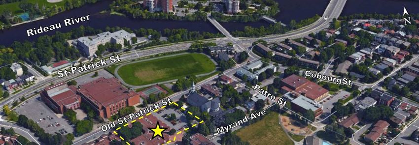
1.0    Introduction
This Planning Rationale has been prepared in support of a Zoning By-law Amendment
application for the land municipally addressed as 500 Old St-Patrick Street.

The subject property is located on the south side of Old St-Patrick Street in the Lowertown
neighbourhood of Ottawa, and consists of a one storey multi-unit commercial building.

The property is designated General Urban Area in the City of Ottawa Official Plan, and the
site is zoned LC1[44] – Local Commercial First Density Urban Exception 44 with a Mature
Neighbourhood Overlay.

The Conseil des écoles publiques de l’Est de l’Ontario, herein after called ‘CEPEO’, has
concluded a lease agreement with the property owner, Centre de services professionnels
communautaires Ste-Anne Inc., herein after called the ‘owner’, and is proposing to use
part of the existing building as classrooms and administrative offices for its De La Salle
French Public Secondary School, located across the street at 501 Old St-Patrick Street.
As such, this Zoning By-law Amendment Application seeks to expand the current
permitted uses of the LC1 Zone to allow a School.

The purpose of this Planning Rationale is to show the suitability of the proposed zoning
amendment with respect to the City of Ottawa’s regulatory and policy framework, the
Provincial Policy Statement 2014, and in the context of the surrounding community.

                                                                                Page 3 of 27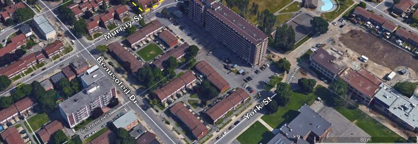
2.0    Overview of the Subject Property

                                                                      Source: Google Earth

   Figure 1: Subject Property

The subject property is located on the south side of Old St-Patrick Street, east of
Beausoleil Drive, west of Patro Street and north of Murray Street and Myrand Avenue in
the Lowertown neighbourhood of Ottawa (Ward 12).

The site has an irregular rectangular shape, with an approximate frontage of 93 meters on
Old St-Patrick Street, a depth of up to approximately 61 meters, and a total area of 1.3
acres. Its legal description is PT LT 1, PL 43586 , N/S MYRAND AV ; PT LTS 16, 17, 18
& 19, PL 43586 , S/S OLD ST PATRICK ST ; PT CHAPEL ST, PL 43586 , (NOW CLOSED
BY CR716451); ALL BEING PARTS 1, 5, 6, 7 & 8 4R2523 ; S/T CR719126, NS729
OTTAWA/NEPEAN, PIN 042130064.

   Figure 2: Survey plan of the property
                                                                                Page 4 of 27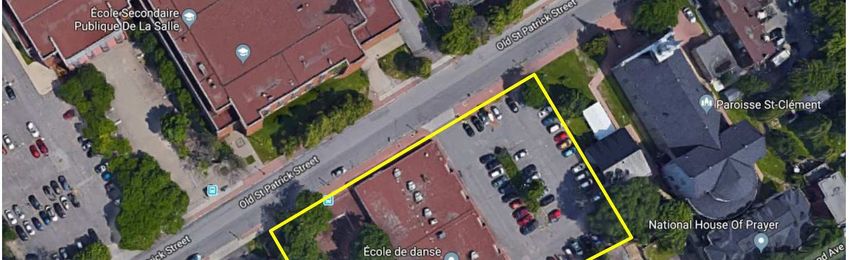
The site consists of a one storey multi-unit commercial building with a gross floor area of
      approximately 1672 square meters. The building is an L-shaped structure built in 1978
      with multiple commercial units which are only partly occupied. Current building occupants
      are the Ste-Anne Medical Clinic and Ottawa Dance Centre Schools.

      The natural topography of the site is flat with a paved parking lot of 1600 square meters
      allowing 50 parking spaces on the east side of the property, as well as a deep front yard
      with mature deciduous trees and shrubs on the west side of the property. An interlocked
      pedestrian pathway provides a natural linkage between the site’s different units and
      parking area, as well as adjacent uses. An OC Transpo bus stop is located in the front
      right-of-way.

      The following images illustrate the subject property and its surrounding area.

                                                                                             Source: Google Maps

      Figure 3: Street view of the subject property

Figure 4: Front view looking East                       Figure 5: Front view looking West

                                                                                        Page 5 of 27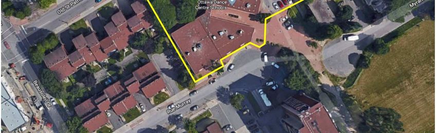
Figure 6: Rear view                                       Figure 7: Rear view with access on Old St-Patrick Street

Figure 8: Views of Ottawa Dance Center Schools (Unit 5)

  Figure 9: Views of Ste-Anne Medical Clinic (Unit 1)

                                                                                          Page 6 of 27
Figure 10: Open area between the 2 parts of the building       Figure 11: Pathway to De La Salle Secondary School

Figure 12: OC Transpo bus stop in front of building            Figure 13: Parking lot on the East side of the property

                                                                                                       Source: Google Maps

          Figure 14: Street view looking at the East side of the property from Old St-Patrick Street

                                                                                                 Page 7 of 27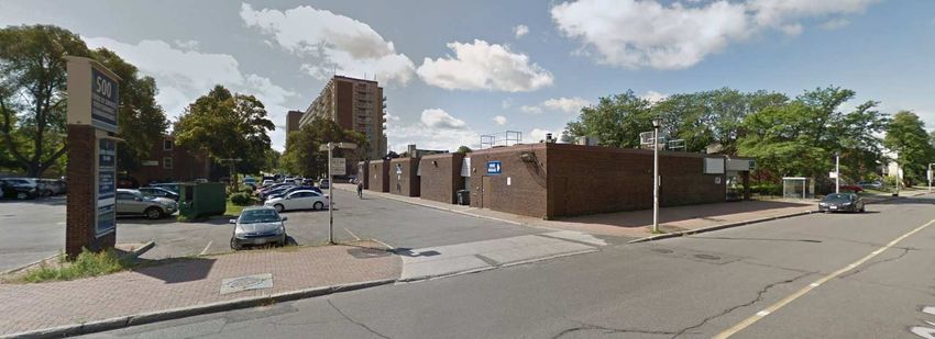
Source: Google Maps

Figure 15: Street view looking at the West side of the property from Old St-Patrick Street

                                                                                             Source: Google Maps

Figure 16: Street view looking North-East toward the property from Murray Street

                                                                                         Source: Google Maps

Figure 17: Street view looking North-West toward the property from Myrand Street

                                                                                       Page 8 of 27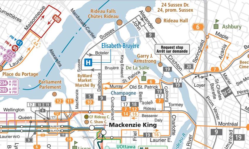
2.1 Site History

The subject property exists in its current form since 1977, following an amalgamation of
existing residential parcels and part of the former Chapel Street right-of-way as a result of
the realignment of St-Patrick Street to its current position.

The site consists of a two-section building built in 1978 comprising multiple commercial
units, which have been occupied by a number of commercial and public service tenants
such as restaurants, a clinic, and a First Nations resource centre. Current building
occupants are the Ste-Anne Medical Clinic and Ottawa Dance Centre Schools.

Due to its location, configuration and former use as an extension of Chapel Street, the site
is an important pedestrian link between surrounding uses, including De La Salle French
Public Secondary School, Le Patro d’Ottawa, Jules Morin Park, and other residential and
non residential uses. Students from De La Salle Secondary School have notably
benefitted from the presence of restaurants and instructional facilities on the site, however
the units are now mostly vacant.

Given the proximity and history between De La Salle and the subject property, the owner
and the CEPEO concluded a lease agreement in the Fall of 2018 to pursue a synergistic
opportunity to use the vacant commercial units as classrooms and administrative offices
to accommodate the school’s overpopulation and anticipated continued growth.

The following figures illustrate the historical evolution of the site as the surrounding area
was redeveloped following the realignment of St-Patrick Street.

   Figure 18: Aerial photo 1965 (Source geoOttawa)
                                                                                  Page 9 of 27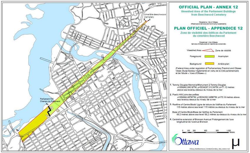
Figure 19: Aerial photograph 1973 (Source Energy, Mines & Resources – Government of Canada)

   Figure 20: Aerial photo 1991 (Source geoOttawa)

                                                                                 Page 10 of 27
3.0 Site Context and Surrounding Area
Figure 21: Bird’s Eye View of Subject Site and Surrounding Area
3.1 Site Context
The subject property is located in the eastern part of the Lowertown neighbourhood of
Ottawa, which is bounded roughly by Rideau Street to the south, Sussex Drive and the
Ottawa River to the north, the Rideau Canal to the west, and the Rideau River to the east.
The south-western part of Lowertown includes the commercial Byward Market area,
however this neighbourhood is predominantly residential in the north and east, with a
cluster of commercial and institutional uses concentrated on Old St-Patrick Street.
Old St-Patrick Street consists of a variety of mixed uses, including residences, institutions
and local commercial businesses. The subject property serves as a local community hub
and pedestrian throughway.
The area immediately surrounding the subject property can be described as follows:
• South: South of Murray Street is residential development, including a 9-storey
community housing complex (R5 zoning) as well as Jules Morin Park.
• East: A religious institution (St-Clément Parish) and the House of Prayer; to the
south-east on Myrand Street is the Ottawa Inner City Health Clinic.
• North: Across Old St-Patrick Street is the CEPEO’s De La Salle French Public
Secondary School.
• West: Residential (R4) 3-storey back-to-back townhouses.
Page 11 of 273.2 Community Amenities
The subject site is located in an established residential neighbourhood containing a range
of amenities. Community amenities within a 500 metres radius include 3 City-owned parks
(Jules Morin, MacDonald Gardens, and Bordeleau), Le Patro d’Ottawa, Ottawa Public
Library Rideau Branch, Champagne Fitness Centre and Pool, Lowertown Pool, two
elementary schools (York Street Public School and École élémentaire catholique Ste-
Anne) and one secondary school, école secondaire publique De La Salle.
3.3 Transportation Network
The subject property is served by OC Transpo with Route 6 circulating on Old St-Patrick
Street. A bus stop is located in the property right-of-way and across the street at De La
Salle Secondary School, providing an enticing option for site users. The site is located
within a kilometre of Rideau Street and the Byward Market, promoting active forms of
transportation. The site is also well positioned within the City’s cycling path network.
Figure 22: OC Transpo Route Map
The property fronts onto Old St-Patrick Street, which connects to Beausoleil Drive and
Cobourg Street, which in turn both connect to St-Patrick Street, a major east-west arterial.
Located one block to the east of the subject property, Cobourg Street provides a north-
south link between St-Patrick Street and Rideau Street, the latter of which is located 4
blocks south and provides many retail and service businesses.
Page 12 of 274.0 De La Salle French Public Secondary School
De La Salle is the CEPEO’s flagship establishment, best known for its Centre d’excellence
artistique de l’Ontario, its diversity of programs and its central location. This school’s
popularity is such that it is currently at 112% occupancy and continues to grow annually,
requiring some courses to be offered outside the main building in both Le Centre Patro
d’Ottawa and the City of Ottawa’s Routhier Community Center to accommodate the
excess capacity of students. Thus, a solution was sought to relieve this overpopulation
which impacts students’ comfort and learning ability.
The role of the CEPEO is to ensure the proper functioning of schools mainly through
provincial funding. The funding process for school construction projects is long, tedious,
and usually takes place over many years. In addition, electoral changes are fraught with
further challenges and delays to funding processes.
In the case of De La Salle, an immediate solution is necessary to ensure the proper
functioning of this iconic institution. The proposed solution consisting of classrooms in an
underutilized commercial property directly across from the main school building is a
relatively quick and inexpensive solution, with little impact to the surrounding
neighbourhood, little adaptation required from the school population, and little to no
change to travel patterns to the site’s proximity to the main building.
It should be noted there is a long history of De La Salle’s pupils occupying the subject
property, which reinforces the natural connection between the two sites. Students have
long been patrons of the subject property’s businesses, including former restaurants and
the existing dance school. The proposed development therefore presents a natural
evolution of the site.
Finally, the CEPEO also intends for all its schools to be more than simple teaching
establishments, but rather well-integrated community hubs. This is accomplished by
forming partnerships with community service providers such as the owner of the subject
property, creating cultural and inclusive gathering spaces, promoting a sense of belonging,
providing access to evening and weekend classes, and allowing the public to rent spaces.
The proposed school annex will be treated as any other school facility and therefore
enhance the services offered to the surrounding community.
Page 13 of 275.0 Proposal
The proposed Amendment is intended to accommodate the construction of classrooms
and supporting administrative offices within the existing building located at 500 Old St-
Patrick Street. The facilities will be used as of the 2019-2020 school year by students and
staff of De La Salle French Public Secondary School, which is located at 501 Old St-
Patrick Street, directly across from the subject property. The Conseil des écoles publiques
de l’Est de l’Ontario (French Public School Board of Eastern Ontario, herein after referred
to as CEPEO) has entered into a lease agreement with the owner of the subject property
to accommodate the school’s overpopulation and continued growth.
This application proposes to amend Zoning By-law 2008-250 to change the zoning at 500
Old St-Patrick Street to LC1 [XXXX], whereas the current zoning is LC1[44]. The proposed
amendment would allow a School as an additional permitted use while retaining the
existing exceptional provisions, as follows:
Exception Provisions
II III IV V
Additional Land
Exception Applicable
Land Uses Uses Provisions
Number Zone
Permitted Prohibited
- gross floor area of commercial uses limited to
2 710 m2
- maximum of 930 m2 of gross floor area for group home
XXXX LC[XXXX] School - each commercial use limited to 372 m2 of gross floor
area except for medical facility or office
- minimum side yard setback of 3 m required for group
home or parking lot
The existing commercial building is to remain in its current form and will accommodate the
new School use. Bicycle parking is also proposed in the front yard; however, no other
exterior works are proposed other than new signage. The landscaping of the property
consists of a combination of deciduous trees, shrubs and gardens, which are also intended
to remain. The intention is to maintain the current exception provisions in order to keep
the existing community services on site while providing additional community amenities
by extending the educational offerings and opportunities in the neighborhood.
The following concept plan was prepared by the CEPEO and illustrates the proposal.
Page 14 of 27Figure 23: Uses and concept for 7 classrooms
Page 15 of 276.0 Policy and Regulatory Context
6.1 Provincial Policy Statement (2014)
Efficient development patterns optimize the use of land, resources, and public investment
in infrastructure and public service facilities. These land use patterns promote a mix of
housing, including affordable housing, employment, recreation, parks and open spaces,
and transportation choices that increase the use of active transportation and transit before
other modes of travel.
Relevant policies:
Policy 1.1.1: Healthy, liveable and safe communities are sustained by: a) promoting
efficient development and land use patterns which sustain the financial well-being
of the Province and municipalities over the long term; b) accommodating an
appropriate range and mix of residential (including second units, affordable housing
and housing for older persons), employment (including industrial and commercial),
institutional (including places of worship, cemeteries and long-term care homes),
recreation, park and open space, and other uses to meet long-term needs;
c) avoiding development and land use patterns which may cause environmental or
public health and safety concerns; d) avoiding development and land use patterns
that would prevent the efficient expansion of settlement areas in those areas which
are adjacent or close to settlement areas; e) promoting cost-effective development
patterns and standards to minimize land consumption and servicing costs.
Policy 1.1.3: Settlement areas shall be the focus of growth and development, and
their vitality and regeneration shall be promoted.
Policy 1.1.3.2: Land use patterns within settlement areas shall be based on: a)
densities and a mix of land uses which: 1. efficiently use land and resources; 2. are
appropriate for, and efficiently use, the infrastructure and public service
facilities which are planned or available, and avoid the need for their unjustified
and/or uneconomical expansion; 3. minimize negative impacts to air quality and
climate change, and promote energy efficiency; 4. support active transportation; 5.
are transit-supportive, where transit is planned, exists or may be developed; and 6.
are freight-supportive; and b) a range of uses and opportunities
for intensification and redevelopment in accordance with the criteria in policy
1.1.3.3, where this can be accommodated.
Policy 1.1.3.3: Planning authorities shall identify appropriate locations and promote
opportunities for intensification and redevelopment where this can be
accommodated taking into account existing building stock or areas,
including brownfield sites, and the availability of suitable existing or
planned infrastructure and public service facilities required to accommodate
projected needs.
Policy 1.6.3: Before consideration is given to developing
new infrastructure and public service facilities: a) the use of
Page 16 of 27existing infrastructure and public service facilities should be optimized; and b)
opportunities for adaptive re-use should be considered, wherever feasible.
Policy 1.6.5: Public service facilities should be co-located in community hubs, where
appropriate, to promote cost-effectiveness and facilitate service integration, access
to transit and active transportation.
Policy 1.6.6.2: Municipal sewage services and municipal water services are the
preferred form of servicing for settlement areas. Intensification and redevelopment
within settlement areas on existing municipal sewage services and municipal water
services should be promoted, wherever feasible.
Policy 1.6.7.1: Transportation systems should be provided which are safe, energy
efficient, facilitate the movement of people and goods, and are appropriate to
address projected needs.
Policy 1.6.7.4: A land use pattern, density, and mix of uses should be promoted that
minimize the length and number of vehicle trips and support current and future use
of transit and active transportation.
The proposal promotes the reintegration of an existing building and maintains the public
services already in place. The project also encourages active transportation by expanding
De La Salle Secondary School within a walkable distance, while maintaining the direct link
from De La Salle to Jules Morin Park.
The proposal is consistent with the applicable policies of the PPS 2014 and the presence
of De La Salle Secondary School provides an important service and facilities for the local
community and the City of Ottawa.
Page 17 of 276.2 City of Ottawa Official Plan (2003)
The subject property is located in the “General Urban Area” designation in accordance
with Schedule B of the City of Ottawa Official Plan.
Section 3.6.1 - General Urban Area
Figure 24: Extract of Schedule B from the CIty of Ottawa Official Plan
The General Urban Area designation permits all types and densities of housing, as well
as employment, retail, service, industrial, cultural, leisure, green space, entertainment and
institutional uses. The evaluation of development applications will be in accordance with
sections 2.5.1 and 4.11 of the Official Plan, and will ensure that these uses:
a. Are compatible and complement surrounding land uses; [Amendment #150, October
19, 2018]
b. Are conveniently located with respect to concentrations of residential development
and provide direct access for pedestrians and cyclists from adjacent residential
areas;
c. Are permitted to cluster with other community-oriented uses, such as parks,
pedestrian linkages, community centres or leisure facilities, in order to facilitate
interaction among residents and contribute to a sense of community;
d. Are situated to take advantage of pedestrian and cycling patterns;
e. Are of a size and scale that will not result in the attraction of large volumes of vehicular
traffic from outside the immediate area.
The proposal is consistent in the context of these policies as the site is surrounded by a
variety of institutional and commercial uses and coexists with the existing residential uses.
It will continue to serve as a community hub and pedestrian link between De La Salle
Page 18 of 27Secondary School, Jules-Morin Park, and surrounding residential areas. The site is
already used as a linkage for pedestrians and cyclists, and public transit is readily
accessible with an OC Transpo stop located in the right-of-way on Old St-Patrick Street.
The new proposed use will have little to no impact on vehicular traffic since the users will
generally walk from De La Salle Secondary School to access it.
Section 2.5.1 – Urban Design and Compatibility
In general terms, compatible development means development that, although it is not
necessarily the same as or similar to existing buildings in the vicinity, nonetheless
enhances an established community and coexists with existing development without
causing undue adverse impact on surrounding properties. It ‘fits well’ within its physical
context and ‘works well’ among those functions that surround it. Generally speaking, the
more a new development can incorporate the common characteristics of its setting in its
design, the more compatible it will be. Nevertheless, a development can be designed to
fit and work well in a certain existing context without being ‘the same as’ the existing
development.
These Design Objectives are broadly stated, and are to be applied within all land use
designations, either at the citywide level or on a site-specific basis.
• To enhance the sense of community by creating and maintaining places with their
own distinct identity.
• To define quality public and private spaces through development
• To create places that are safe, accessible and are easy to get to, and move
through.
• To ensure that new development respects the character of existing areas.
• To consider adaptability and diversity by creating places that can adapt and evolve
easily over time and that are characterized by variety and choice. [OMB decision
#2649, September 21, 2006]
• To understand and respect natural processes and features in development design
• To maximize energy-efficiency and promote sustainable design to reduce the
resource consumption, energy use, and carbon footprint of the built environment.
The built form of the existing commercial building is to remain in its current state and no
major modifications are proposed to the building. Bicycle parking and signage will be
incorporated to accommodate students and identify the new classrooms. Additionally, the
school land use respects the forms and functions of the surrounding lands and will coexist
without causing undue adverse impacts on surrounding properties. Furthermore, there are
several other schools and institutional uses in the vicinity.
Section 2.5.5 – Cultural Heritage Resources
The municipality sets out specific requirements when reviewing development applications
that affect cultural heritage resources, like a heritage conservation district, as designated
under the Ontario Heritage Act. The existing building will continue to respect the heritage
character of the surrounding neighborhood. A CHIS was not required for this application.
Page 19 of 27Section 4 - Review of Development Applications
This section outlines the specific policies the City of Ottawa uses to review development
applications in order to meet the objectives contained in the Official Plan.
Section 4.1 – Site-Specific Policies and Secondary Policy Plans
The subject site is not subject to any secondary plan. The proposal is within the Viewshed
Area of the Parliament Buldings from Beechwwod Cemetery, but considering that it is a
1-storey building, the proposal will not impact the viewshed area.
Figure 25: Viewshed Area of the Parliament Buildings from Beechwood Cemetary
Section 4.2 – Adjacent Land Use Designations
There are no land use designations as shown on Schedule B of the City of Ottawa Official
Plan in proximity to the subject property that would trigger special requirements.
Section 4.3 – Walking, Cycling, Transit, Roads and Parking Lots
The site is well serviced by the City of Ottawa’s public transit network as bus stops are
located in front of the building and provide service to all areas of the City and its outer
limits. Old St-Patrick Street will continue to provide a safe and pedestrian-oriented
interface with easy accessibility for the surrounding residential uses. Old St-Patrick Street
is part of the Phase 1 of the Ottawa Cycling Plan (OCP2013), identified as P1-38, and
Page 20 of 27sidewalks are located on both side of Old St-Patrick. The subject site is notably used as a
natural pathway between De La Salle and Jules Morin Park, echoing the historical use of
the property as an extension of Chapel Street until the 1970s. The small scale of the
proposed classrooms is not anticipated to generate high volumes of traffic or parking
concerns. There are 50 existing parking spaces on the site, which is above and beyond
the required number of 1,25 spaces per classroom given the proposed addition of 7
classrooms.
A traffic statement was not required for this application.
Figure 26: Cycling and Pedestrian Plan
Section 4.4 – Water and Wastewater
The site is accessed to the existing public water supply and public wastewater services.
There are no concerns for the need of additional infrastructure.
Section 4.5 – Housing
The provisions of this section are not applicable to the subject property, as it does not
propose affordable or rental housing. The proposal also keeps the residential uses as part
of the permitted uses, therefore can be re-purposed for housing use.
Section 4.6 – Cultural Heritage Resources
A CHIS was not required for this application.
Page 21 of 27Section 4.7 – Environmental Protection
A Phase I Environmental Site Assessment was required for this application. Based on the
report, the surrounding land use consists of residential, institutional and commercial
properties that are not considered to pose a concern to the subject site. No environmental
concerns were identified with the current use of the subject property or adjacent lands.
A Phase II – Environmental Site Assessment is not required for the subject property.
Section 4.8 – Protection of Health and Safety
The subject site is not affected by designations on Schedule K of the Official Plan including
flood plains, well head protection or unstable soil. The subject site is not within a
designated sensitive noise area.
Section 4.9 – Energy Conservation Through Design
The application does not propose any new development.
Section 4.10 – Green Space Requirements
Cash-in-lieu of parkland payment is not required for this application.
Section 4.11 – Compatibility
This section relates to the compatibility of the proposed development with the surrounding
context and community. The criteria in this section provide an opportunity to objectively
evaluate the compatibility of the proposed development. When evaluating compatibility of
development, the site’s land use designation, applicable site-specific policies, and urban
design guidelines are to be considered.
Having carefully considered these measures, the proposed concept for the zoning is
appropriate, as follows:
a. Traffic: The scale and density of the proposal would not have any significant impact
on the transportation system in this area. The majority of users will use active
transportation to access the site from De La Salle Secondary School, and therefore
the impact on the surrounding area will be minimal.
b. Vehicular Access: Vehicular access to and from the site is deemed appropriate to
support the proposed use as an extension of the neighbouring secondary school.
c. Parking Requirements: The application provides an efficient number of parking
places.
d. Outdoor Amenity Areas: An Amenity Area is not required for the proposed use.
e. Loading Areas, Service Areas, and Outdoor Storage: Loading space is available
on site but is generally not required in LC zone except in the case of uses on lots
abutting Rideau Street, Sparks Street and Bank Street in Area A (Central Area) of
Page 22 of 27Schedule 1. Vehicle loading spaces must be provided for each use where more
than one use is located in a building or on a lot, however since each of these uses
on the subject property occupies less than 1000 m², loading space is not required.
The proposal therefore complies with the loading area regulation.
f. Lighting: No additional site lighting features are proposed. The use of external
lighting is marginal and limited due to the daytime operating hours.
g. Noise and Air Quality: The additional use will not generate significant noise and air
quality concerns.
h. Sunlight: Sun shadowing impacts are not expected to be problematic. A
Sun/Shadow Study was not required for this application.
i. Microclimate: The existing building is in context in terms of height and massing
with the existing neighbourhood, and therefore, there should not be any
microclimate concerns.
j. Supporting Neighbourhood Services: The proposed development will be
adequately serviced by existing neighbourhood amenities. The development is
located within proximity of a variety of parks, amenities, and community services,
and the area is well serviced by the bus transit system, cycling paths, and
sidewalks.
Page 23 of 276.3 City of Ottawa Zoning By-Law 2008-250
The current zoning of the site under the City of Ottawa Comprehensive Zoning By-law
2008-250 is LC1[44], Local Commercial Zone - Exception 44 with a Mature Neighborhood
Overlay. The zoning designation of the North and East abutting properties is I1A, which
allows the proposed use.
According to the City of Ottawa Zoning By-Law, the purpose of the LC zone is to:
1. allow a variety of small, locally-oriented convenience and service uses as well
as residential uses in the General Urban Areas and in the Residential
Character Areas of the Central Area designations of the Official Plan;
2. restrict the non-residential uses to individual occupancies or in groupings as
part of a small plaza that would meet the needs of the surrounding residential
areas;
3. provide an opportunity to accommodate residential or mixed uses development;
and
4. impose development standards that will ensure that the size and scale of
development are consistent with that of the surrounding residential area.
With the addition of a School use while maintaining current uses and existing provisions,
the purpose of the LC zone will still be respected. The small scale of the proposed use will
have little impact on the character of the residential area, especially considering the
existing mix of institutional and local commercial zones in the surrounding area.
Additionally, the proposal provides an ideal transition zone between surrounding uses,
and extends the purpose of the adjacent I1A - Minor Institutional Zone, which is to:
(1) permit a range of community uses, institutional accommodation and emergency
service uses to locate in areas designated as General Urban Area or Central Area
in the Official Plan; and
(2) minimize the impact of these minor institutional uses located in close proximity to
residential uses by ensuring that the such uses are of a scale and intensity that is
compatible with neighbourhood character.
Figure 27: Zoning map
Page 24 of 27Permitted Uses
The permitted uses of the LC1 zone include:
Residential: apartment dwelling low rise, bed and breakfast, dwelling unit, group home,
home-based business, home-based day care, planned unit development,
retirement home, converted retirement home, rooming house, stacked
dwelling and townhouse dwelling.
Non-residential: animal care establishment, artist studio, bank, bank machine, community
health and resource centre, convenience store, day care, instructional
facility, library, medical facility, payday loan establishment, personal service
business, post office, restaurant, retail food store, retail store, service and
repair shop, small batch brewery, urban agriculture.
The LC1[44] Zone does not permit a School use. As such, this application seeks to amend
the Zoning By-law to permit it.
Urban Exception 44
The subject site is currently subject to Urban Exception 44, detailed in the following table:
Exception Provisions
I II III IV V
Additional Land
Exception Applicable
Land Uses Uses Provisions
Number Zone
Permitted Prohibited
- gross floor area of commercial uses limited to
2 710 m2
44
- maximum of 930 m2 of gross floor area for group
(By-law
home
2015- LC[44]
- each commercial use limited to 372 m2 of gross
197)
floor area except for medical facility or office
- minimum side yard setback of 3 m required for
group home or parking lot
The current proposal would retain the existing provisions while adding ‘School’ as an
Additional Land Use Permitted.
Page 25 of 27Gross Floor Area
Each commercial use is limited to 372 square metres of gross floor area, except for
medical facility of office uses. The Ste-Anne Medical Center and Ottawa Dance Centre
School, the current building occupants, currently respect this provision.
The proposed additional use is considered an institutional use, and as such the proposed
851 square metre development would not be restricted by the Gross Floor Area provisions.
Parking
Parking is not required for non residential uses in the LC1 zone. However, parking for a
secondary school in other zones minimum required is 1.25 parking per classroom. In the
proposed change, the construction implies a maximum of 7 classrooms, and therefore 9
parking spaces.
The existing parking area provides 50 parking spaces, which is above and beyond this
requirement.
Bicycle Parking
Bicycle parking requirements for a school are 1 space per 100 m² of gross floor area.
Considering the proposed 851 square metres occupied by the school, the required number
would be 9 bicycle parking spaces.
While bicycle parking is provided at De La Salle Secondary School’s main campus located
at 501 Old St-Patrick Street, additional bicycle parking will be provided in accordance with
this provision.
Loading Space
Loading space is generally not required in LC zone except in the case of uses on lots
abutting Rideau Street, Sparks Street and Bank Street in Area A (Central Area) of
Schedule 1. Vehicle loading spaces must be provided for each use where more than one
use is located in a building or on a lot, however since each of these uses on the subject
property occupies fewer than 1000 m², loading space is not required.
Mature Neighbourhoods Overlay
The Mature Neighbourhoods By-law does not apply to non-residential development. Since
all proposed site improvements will occur inside the existing building, the proposed
development will maintain the existing building shell and parking spaces, having no impact
on the established character of the surrounding streetscape.
Page 26 of 27You can also read