Schedule i. Regional Context Statement - District of West Vancouver: Official Community Plan (REVISED DRAFT) - Metro Vancouver
←
→
Page content transcription
If your browser does not render page correctly, please read the page content below
District of West Vancouver: Official Community Plan (REVISED DRAFT)

Schedule i.
Regional Context Statement
Official Community Plan: Schedule i. Regional Context Statement

Regional Context Statement
______________________________________________________________________

The District of West Vancouver is required, under section 446(1) of the Local
Government Act, to include a Regional Context Statement in its Official Community
Plan. The Regional Context Statement is the component of the Official Community Plan
that links the District’s land use plans and policies to the Regional Growth Strategy. It
must identify the relationship between the Official Community Plan and the approved
Regional Growth Strategy. If applicable, it must also identify how the Official
Community Plan will be made consistent with the Regional Growth Strategy over time.

“Metro Vancouver 2040 – Shaping our Future” (Regional Growth Strategy Bylaw
1136, 2010) (hereafter, Metro 2040) was endorsed by the District of West Vancouver in
March of 2011, and was adopted by the Metro Vancouver Regional Board as the
Regional Growth Strategy for Metro Vancouver in July of 2011. The District’s Regional
Context Statement was updated in March of 2015 to reflect its Official Community
Plan’s compliance with Metro 2040.

Metro 2040 sets out five goals to guide the Region’s own actions, and those of its
member jurisdictions, in achieving a vibrant, diverse, prosperous and sustainable
region. These goals are to:
       (1)  Create a compact urban area
       (2)  Support a sustainable economy
       (3)  Protect the environment and respond to climate change impacts
       (4)  Develop complete communities, and
       (5)  Support sustainable transportation choices

The Regional Context Statement describes how the Official Community plan addresses
the five major goals and the strategies of Metro 2040; how the District of West
Vancouver will fulfill its required municipal roles; and how the District will address the
population and employment projections set by Metro Vancouver.

Due to its history as a community of residential neighbourhoods, and its natural setting
and topography, the District of West Vancouver does not contain agricultural lands and
has no industrial land base. It cannot, therefore, address all of the strategies set out in
Metro 2040. However the goals set out in the District’s Official Community Plan, where
they do apply, are consistent with the vision and policies of Metro 2040.

To assist in long range planning, Metro 2040 has provided projections for population
and employment for all municipalities within Metro Vancouver. These projections
include a population of 60,000, a total of 24,500 dwelling units and an employment level
of 29,000 jobs within the District and Squamish Nation lands located within our
municipal boundary by the year 2041. This Regional Context Statement describes how

                                                                                           Page 1
Official Community Plan: Schedule i. Regional Context Statement
the District will work towards aligning with a portion of these projections for lands within
the District’s jurisdiction over time.
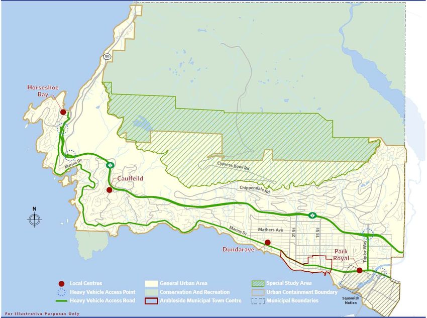
Metro 2040 sets out broad land use designations for all of Metro Vancouver. The
“Regional Land Use Designations” map (Map 16) illustrates how the Regional
designations apply to the District of West Vancouver. It also illustrates the Urban
Containment Boundary, the boundary of the Ambleside Municipal Town Centre and the
boundary of Squamish Nation lands (Capilano Indian Reserve No. 5), which are located
within West Vancouver’s municipal boundaries.
The District of West Vancouver may amend this Official Community Plan to adjust the
boundaries of the Ambleside Municipal Town Centre on completion of the local area
planning process for Ambleside, provided such adjustments satisfy the requirements set
out in section 6.2.8 of Metro 2040, and meet the guidelines set out in Table 3
(Guidelines for Urban Centres and Frequent Transit Development Areas). The District
will also notify Metro Vancouver of such adjustments, as per the requirements set out in
section 6.2.9 of Metro 2040.
Metro 2040 includes a number of “Special Study Areas” where Municipalities are
undertaking work that could result in changes to regional designations or in a change to
the location of the Urban Containment Boundary. West Vancouver’s Upper Lands are
identified as one of the “Special Study Areas”, as shown in the “Regional Land Use
Designations” map (Map 16). This “Special Study Area” currently includes undeveloped
lands that span east to west above 1200 feet in elevation. As indicated in this OCP, the
District has policy to concentrate future Upper Lands development into compact and
complete neighbourhood(s) in and around the Cypress Village and adjacent Cypress
West areas, through the preparation of Area Development Plan(s). This would
significantly reduce the area of land developed, and permanently protect areas with
greater environmental and recreational values above the 1200-foot contour and west of
Eagle Creek below 1200-foot contour from future residential development. The current
“Special Study Area” will remain until Council has sufficient policy in place to guide
future development in the Upper Lands with adopted Area Development Plan(s) for
Cypress Village/Cypress West. At that time, the District anticipates working with Metro
Vancouver to remove Metro 2040’s “Special Study Area” as appropriate to reflect and
implement Council’s direction and seek to re-designate those newly protected lands
west of Eagle Creek below 1200 feet as well as Special Study Area lands above the
1200 foot contour as Conservation & Recreation Land Use in Metro 2040.
The “Statement of Alignment between the Policies of the OCP and Metro 2040”
identifies how the policies of the Official Community Plan comply with Metro 2040, and
where applicable, describes how the Plan will be brought into “alignment” over time.
Page 2Official Community Plan: Schedule i. Regional Context Statement
Map 16: Regional Land Use Designations
Page 3Official Community Plan: Schedule i. Regional Context Statement
Statement of Alignment between the Policies of the OCP and Metro 2040
Goal 1: Create a Compact Urban Area
The District of West Vancouver is a community of residential neighbourhoods defined
by historic patterns of development and natural landscape features. The coastline and
rugged mountain terrain create natural limits to development. New development will
consist of infill or redevelopment within existing neighbourhood areas and strengthening
existing centres and corridors, with the exception of the Upper Lands. There, lands
within the Urban Containment Boundary will be subject to comprehensively planned
future neighbourhoods in and around the future Cypress Village, subject to detailed
Area Development Plans which direct development to lands most suitable for
development and protect environmental and recreational assets.
Metro 2040 Strategy Official Community Plan
1.1.3 a The Urban Containment Boundary is shown on the ‘Regional
Depict the Urban Land Use Designations’ map (Map 16).
Containment
Boundary on a map.
1.1.3 b In Table A.1 of Metro 2040, projections for the District of West
Provide dwelling unit Vancouver, including the Squamish Nation land, are:
and employment
projections with 2011 2021 2031 2041
reference to Population 46,300 51,000 56,000 60,000
Guidelines in Table Dwellings 18,400 20,600 23,100 24,500
A.1. Employment 18,700 24,000 27,000 29,000
Demonstrate how the
Plan will work toward Analysis conducted by the District of West Vancouver in 2016,
accommodating specific to the area within the municipality’s jurisdiction,
projected growth produced the following growth projections:
within the Urban
Containment 2011 2021 2031 2041
Boundary. Population 43,500 45,000 49,000 54,000
Dwellings 17,000 18,000 20,000 22,000
Employment 14,500 16,500 18,500 21,000
These projections are generally consistent with Metro 2040.
West Vancouver is expected to increase by ~10,000 people
by 2041. This represents an annual growth rate of 0.74%.
Since the analysis, new Census data have been published
and indicate that the population of West Vancouver was
approximately 42,500 and the occupied dwelling units was
approximately 17,000 in 2016.
Page 4Official Community Plan: Schedule i. Regional Context Statement
Metro 2040 Strategy Official Community Plan
Section 2 A “Housing & Neighbourhoods” describes where
new dwelling units will be developed to achieve the estimated
increase in population. New housing units are expected to
increase by 5,000 by 2041. Population growth will be
accommodated entirely within the Urban Containment
Boundary in areas shown on Map 16 ‘Regional Land Use
Designations’.
Within these areas:
• Section 2 A “Housing & Neighbourhoods” 2.1 “Existing
Neighbourhoods” contains policies to develop 300 to
400 sensitive infill units consisting of smaller houses on
smaller lots, rental and strata coach houses, duplexes
and basement suites, and to support 300 to 350
ground oriented multi-family and mixed-use units along
the Marine Drive Transit Corridor, adjacent to
“neighbourhood hubs” and through limited site-specific
zoning changes in keeping with the policies of the Plan;
• Section 2 A “Housing & Neighbourhoods” Policies
2.1.12 and 13 provide 500 to 750 units in the Marine
Drive Local area Plan, 1,000 to 1,200 units in the
Ambleside Town Centre, 500 to 600 units in the Taylor
Way Corridor and 200 to 300 units in Horseshoe Bay;
and
• Section 2 A “Housing & Neighbourhoods” 2.2 “Future
Neighbourhoods” provides for an overall residential
density of 2.5 residential units per gross acre of
undeveloped public and private land identified below
the 1200 foot contour, which, through the transfer of
development rights, and the approval of Area
Development Plans for Cypress Village and Cypress
West, will provide for a range of housing types, tenures
and unit sizes in these new neighbourhoods.
Section 2 B “Local Economy” 2.3 “Local Economy and
Employment” contains policies to strengthen commercial
centres and nodes at Ambleside, Park Royal and Horseshoe
Bay, to regenerate Dundarave and Caulfield Village Centres
and to plan for a range of commercial uses in the new
Cypress Village. Policies call for expansion of commercial
and mixed use zones to broaden economic opportunities and
the expansion of retail and services in local commercial
nodes, to support home based businesses, support visitor
accommodations and tourism, encourage versatile spaces
such as live-work and production retail that support arts and
Page 5Official Community Plan: Schedule i. Regional Context Statement
Metro 2040 Strategy Official Community Plan
culture sector development and encourage entertainment and
cultural and special events. Policies 2.3.16 to 2.3.21 speak to
enhancing employment through promoting opportunities and
innovation in sectors such as health care, technology,
research, film, and through partnerships, collaborations and
support for small business.
All land outside of the Urban Containment Boundary is
designated for Conservation and Recreation uses. All
Residential Neighbourhoods as shown on Map 1 and Local
Planning Areas as shown on Maps 3 through 9 are within the
Urban Containment Boundary.
1.2.6 a The Ambleside Municipal Town Centre is designated as a
Provide dwelling unit Municipal Town Centre in Metro 2040. Its boundaries are
and employment identified on Map 16 ‘Regional Land Use Designations’.
projections that
indicate the A Local Area Plan for the Ambleside area is estimated to
municipal share of accommodate 1,000 to 1,200 new units as set out in Section
planned growth and 2 A “Housing & Neighbourhoods” Policy 2.1.13. This
that contribute to represents a 20-24% municipal share of planned dwelling unit
achieving the growth that will contribute to achieving the regional target for
regional share of growth in Urban Centres. Detailed dwelling unit and
growth for Urban employment projections, as well as the municipal shares of
Centres and regional growth targeted for Urban Centres for the Ambleside
Frequent Transit Municipal Town Centre will be prepared in conjunction with
Development Areas the Local Area Plan Review.
(FTDAs) as set out in
Table 2. The District has not designated Frequent Transit
Development Areas (FTDAs).
1.2.6 b
Include policies for
Urban Centres which:
(i) Identify Urban The Ambleside Municipal Town Centre is identified as a
Centre locations Municipal Town Centre on Map 16 ‘Regional Land Use
and boundaries; Designations’. Adjustments may be made to the boundaries
of the Ambleside Municipal Town Centre upon the completion
of the Local Area Plan Review, as provided for by Policy 6.2.8
of Metro 2040.
(ii) Focus growth and The District’s highest residential densities are centred in the
development in Ambleside Town Centre, followed by the commercial areas of
Urban Centres Park Royal, Dundarave, and Horseshoe Bay.
generally
consistent with Section 2 A “Housing & Neighbourhoods” Policy 2.1.13 calls
Table 3 - for an estimated increase of 1,000 to 1,200 new units in the
Ambleside Municipal Town Centre area.
Page 6Official Community Plan: Schedule i. Regional Context Statement
Metro 2040 Strategy Official Community Plan
Guidelines for Section 2 B “Local Economy” 2.3 “Local Economy and
Urban Centres; Employment” emphasizes the Ambleside Municipal Town
Centre as the heart of West Vancouver with commercial, arts
and culture, office, civic visitor accommodation and waterfront
recreation uses.
Section 2 C “Transportation & Infrastructure” Policy 2.4.17
calls for the development of parking management strategies
in Town and Village Centres, which includes the Ambleside
Municipal Town Centre, to meet the community’s needs and
support more sustainable modes of travel.
Schedule ii “Existing Area-Specific Policies & Guidelines”,
Guidelines BF-C3 “Ambleside Village Centre”, Policy BF-C
4.2 call for a more intense, interesting commercial area, and a
more vibrant core encouraging a concentration of commercial,
retail and restaurant uses. Policy BF-C 4.4 is to increase the
proportion of residential use, particularly in the periphery of
the current commercial area, emphasizing its role as a “living”
centre for civic and cultural activities.
(iii) Encourage office Section 2 B 2.3 “Local Economy” Policy 2.3.1 emphasises the
development in Ambleside Municipal Town Centre as a location for offices.
Urban Centres Specific policies on office development will be addressed in
through policies conjunction with the Local Area Plan Review.
and/or incentives;
(iv) With the Section 2 A “Existing Neighbourhoods” Policy 2.1.16 and
provision of transit, 2.1.17 provide for the reduction of off-street parking
reduce residential requirements to support existing rental housing and promote
and commercial new market and non-market rental, seniors and supportive
parking where housing close to transit and amenities.
appropriate.
Policy 2.1.23 calls for advancing community energy efficiency
by supporting alternative transportation through housing
location and parking requirements.
Schedule ii “Existing Area-Specific Policies & Guidelines”,
Guideline BF-C 3 “Ambleside Village Centre” strongly
encourages shared parking, especially surface parking areas
off lane, with adequate signage to inform the public of share
arrangements.
1.2.6.c Not applicable (FTDAs have not been identified at this time).
Include policies for
Frequent Transit
Development Areas
(FTDAs) to identify
Page 7Official Community Plan: Schedule i. Regional Context Statement
Metro 2040 Strategy Official Community Plan
and focus growth and
development in these
areas
1.2.6 d
Include policies for
General Urban areas
which:
(i) Identify General General Urban areas are identified on the “Regional Land Use
Urban areas; Designations” Map (Map 16).
(ii) Ensure Policy 2 A “Housing and Neighbourhoods” Policy 2.1.13
development in the provides estimates for new units in Ambleside Town Centre
General Urban and other local area plans.
areas outside of
the Urban Centre Policy 2.1.14 states that mixed-use and apartment forms are
is lower density; prioritized in core areas and ground-oriented multifamily forms
such as townhouses and duplexes are forms to transition to
adjacent single-family neighbourhoods.
Policy 2 A “Housing and Neighbourhoods” 2.1 “Existing
Neighbourhoods” limits development to sensitive infill units,
such as smaller units, coach houses and duplexes.
(iii) Identify small Map 16 ‘Regional Land Use Designations’ identifies
scale Local Horseshoe Bay, Dundarave, Caulfield, and Park Royal as
Centres where Local Centres.
appropriate;
Section 2 B 2.3 “Local Economy and Employment” Policies
2.3.2 to 2.3.4 describe the role of each: Park Royal as a
Regional Shopping Centre; Horseshoe Bay Village Centre
with a visitor accommodation and tourism element;
Dundarave and Caulfield Village Centres with small-scale
retail and service, mixed residential and commercial uses.
(iv) Exclude non- Commercial uses are identified in Section 2.B “Local
residential, major Economy”. Map 10 ‘Commercial and Tourist Areas’ identifies
trip generating all existing and future areas of commercial use, including
uses from areas marine commercial, Cypress Mountain and the future Cypress
outside Urban Village. The existing non-residential major trip-generating
Centres and uses of municipal and cultural facilities are already
FTDAs; established inside the Municipal Town Centre. Other
established non-residential major trip-generating uses outside
of the Municipal Town Centre include existing marine
commercial, the Cypress Mountain ski and recreation area
and the BC Ferries Horseshoe Bay terminal, as well as Park
Royal Shopping Centre located on the transit network.
Page 8Official Community Plan: Schedule i. Regional Context Statement
Metro 2040 Strategy Official Community Plan
The District’s OCP policies to guide future land use change do
not support new non-residential major trip-generating uses of
an industrial nature, business parks, or shopping malls which
would be likely to generate a significant number of new trips.
New non-major residential major trip generating uses, such as
primary office use or major civic institutions, are not
contemplated outside of the Municipal Town Centre.
The District does not have FTDAs.
(v) Encourage infill Map 1 ‘Neighbourhood Infill Opportunities’ identifies existing
development by neighbourhoods where infill development is to be directed.
directing growth to
established areas; Section 2 A “Housing & Neighbourhoods” Policy 2.1.1 calls for
amending subdivision standards to allow smaller houses on
smaller lots, and Policy 2.1.2 calls for updating zoning
provisions to increase the supply of coach houses in existing
detached residential areas.
Schedule ii “Existing Area-Specific Policies & Guidelines”,
Guidelines BF-B 11 identifies locations in established areas
for duplex development. Guidelines BF-B 12 identifies the
Evelyn Drive Planning area, immediately adjacent to Park
Royal, as a neighbourhood redevelopment area providing for
a variety of housing types, built forms and densities.
Guidelines BF-B 13 identifies the block bounded by Esquimalt
Avenue, 20th Street, Fulton Avenue and 21st Street as an
“Infill” area suitable for a combination of smaller single family
dwellings, coach houses, duplexes, and triplexes.
1.2.6 e The Ambleside Municipal Town Centre is completely within
Ensure Regional the General Urban designation.
Industrial, Mixed
Employment and FTDAs have not been identified at this time.
Recreation and
Conservation
designations prevail
in Urban Centre and
FTDAs
1.2.6.f
For Urban Centres,
FTDAs and General
Urban areas, include
policies which:
(i) Minimize impacts Not applicable (there are no areas designated for Industrial
of urban uses on use).
industrial activities;
Page 9Official Community Plan: Schedule i. Regional Context Statement
Metro 2040 Strategy Official Community Plan
(ii) Encourage safe Section 2 C “Transportation & Infrastructure” Policies 2.4.1 to
and efficient 2.4.6 speak the completion of a safe, accessible and
transit, cycling and connected pedestrian and cycling network integrated to Town
walking; and Village Centres.
Policy 2.4.4 calls for the development of minimum pedestrian
and cyclist design and infrastructure guidelines for new
private and public development projects.
(iii) Implement transit Section 2 C “Transportation & Infrastructure” Policy 2.4.8
priority measures contains policies to expand bus priority measures and transit-
where appropriate; supportive road treatments along Marine drive to increase
efficiency of transit service.
(iv) Support district Section 2 A “Housing & Neighbourhoods” Policy 2.1.23
energy systems encourages the development of renewable energy generation
and renewable to advance community energy efficiency and reduce GHG
energy generation; emissions.
Section 2 D “Natural Environment” Policy 2.6.23 supports the
incorporation of renewable energy in public and private
buildings, and the development of renewable energy systems
as opportunities arise.
1.3.3 a Not applicable (there are no Rural designated areas).
Identify Rural Areas.
Page 10Official Community Plan: Schedule i. Regional Context Statement
Goal 2: Support a Sustainable Economy
Section 2 B “Local Economy” of the West Vancouver Official Community Plan contains
policies to strengthen commercial centres and nodes, to support tourism, to promote
opportunities and innovation, and to support a vibrant and diverse local economy.
Metro 2040 Strategy Official Community Plan
2.1.4 a Section 2 B “Local Economy” “Local Economy” Policy 2.3.1
Include policies that emphasises the Ambleside Municipal town Centre as the
support appropriate heart of the District, supporting commercial land uses
economic including retail, service, office, arts and culture, civic services
development in and facilities, visitor accommodation and recreation.
Urban Centres,
FTDAs, Industrial Policy 2.3.6 calls for the expansion of commercial and mixed-
and Mixed use zones to broaden economic opportunities and stimulate
Employment areas. employment growth.
Policy 2.3.10 supports the development of visitor
accommodation including boutique hotel(s) in the Ambleside
town Centre.
Schedule ii “Existing Area-Specific Policies & Guidelines”,
Guidelines BF-C 3 “Ambleside Village Centre” contain
directions to create a more intense and vibrant commercial,
civic and service area, to increase its growing role as a home
for civic and cultural activities, to strengthen connections to
the waterfront increase cultural and recreational activity,
encourage mixed use projects and create a sense of place
that will reinforce the role of Ambleside as West Vancouver’s
Town Centre.
The District does not have FTDAs, Industrial or Mixed
Employment areas.
2.1.4 b Section 2 B “Local Economy” Policy 2.3.1 emphasises the
Support the Ambleside Municipal Town Centre as a location for offices.
development of office
space in Urban
Centres through
policies and
incentives.
2.1.4.c Section 2 B “Local Economy” specifies that commercial areas
Include polices that consist of Ambleside as the Municipal Town Centre, as well
discourage major as Park Royal regional shopping centre, the existing local
commercial and commercial centres of Dundarave, Caulfield and Horseshoe
institutional Bay, and dispersed smaller commercial sites. Map 10
development outside ‘Commercial and Tourism Areas’ identifies all major existing
Page 11Official Community Plan: Schedule i. Regional Context Statement
Metro 2040 Strategy Official Community Plan
of Urban Centres and and future commercial areas, including the proposed future
FTDAs. Cypress Village commercial area, and Map 15 ‘Major
Community Social Assets’ identifies all major institutional
uses. Major commercial and institutional developments will
be limited outside of the above-noted areas.
Section 2 B “Local Economy” Policy 2.3.1 identifies Ambleside
Municipal Town Centre as the civic heart of West Vancouver.
While commercial and institutional development may be
appropriate in General Urban Areas outside of the Urban
Centres, major commercial and institutional development will
be discouraged outside of the Ambleside Municipal Town
Centre.
The District has not identified FTDAs.
2.1.4 d This section is not applicable, as the District of West
Show how Special Vancouver does not contain hospitals, or post-secondary
Employment Areas institutions.
are supported
through land use and
transportation
policies.
2.2.4 a to 2.3.6.a - These sections are not applicable as there are no Industrial,
Identify Industrial, Mixed Employment or Agricultural designated areas within
Mixed Employment West Vancouver.
and Agriculture
areas.
2.3.6 b Although there are no areas in West Vancouver within the
Include policies to Agriculture designation, Policy Section 2 E “Social Well-Being”
support agricultural Policy 2.9.12 supports urban agriculture, community gardens,
viability. farmers’ markets and related initiatives.
Page 12Official Community Plan: Schedule i. Regional Context Statement
Goal 3: Protect the Environment and Respond to Climate Change Impacts
The Official Community Plan describes the context of the District as a collection of
distinct neighbourhoods set within nature, defined by the terrain of the North Shore
Mountains, numerous watersheds and a rugged coastline. Over 60% of the land base
in West Vancouver is designated for major parks and for watershed protection. Section
2 D “Parks & Environment” promotes the protection and management the District’s
natural resources and preservation of its sensitive ecosystems. The Plan contains
policies, development permit area designations and guidelines to protect and enhance
natural areas, to ensure the safety of people and property from natural hazards and to
respond to the impacts of climate change.
Metro 2040 Strategy Official Community Plan
3.1.4 a Conservation and Recreation areas and their boundaries are
Identify shown on the Map 16 ‘Regional Land Use Designation’.
Conservation and
Recreation
areas and their
boundaries on a
map.
3.1.4 b (i) to (vi): Policy 2 D “Parks & Environment” 2.6 “Natural Environment”
Include policies to “Sensitive habitats and natural assets” contains policies to
protect Conservation identify ecological important assets and develop strategies to
and Recreation areas protect and manage these features through a variety of
generally consistent conservation tools, to protect the ecological value of Telegraph
with public service Hill and Tyee Point.
infrastructure,
environmental Policy 2 D “Parks & Environment” Policies 2.7.1 to 2.7.6 contain
conservation, policies to acquire, maintain and care for the District’s parks
recreation, education and open spaces, and to support compatible activities in parks
and research, and open spaces to advance environmental stewardship.
commercial, tourism
and cultural uses and Policy 2 D “Parks & Environment” 2.7 “Parks & Trails”
limited agriculture “Protecting the Upper Lands natural assets” contains policies
to manage Limited Use and Recreation lands above 1200 feet
by dedicating district owned land as parkland, assessing
specific recreational opportunities on private land, and seeking
to acquire land with high environmental value or recreation
potential. The policies also protect environmental values below
1200 feet in the Upper Lands by prioritizing areas of significant
ecological values and transferring development density to
future neighbourhoods in and around Cypress Village. Policies
seek to balance recreation uses with environmental and
cultural values, and allow recreational access on authorized
trails.
Page 13Official Community Plan: Schedule i. Regional Context Statement
Metro 2040 Strategy Official Community Plan
Policy 2 D “Parks & Environment” contains policies to protect
watercourse corridor and riparian areas (Policy 2.6.7) and to
protect the foreshore (Policy 2.6.10).
3.1.4 c Section 2 D “Parks & Environment” Policy 2.7.5 contains
Buffer Conservation policies to use greenbelts and boulevards to support
and Recreation areas neighbourhood definition and character and provide forest
from activities in buffers along major roads.
adjacent areas.
Section 2 D “Parks & Environment” Policy 2.7.9 calls for a ‘soft
edge’ of development and appropriate urban-forest interface
and buffer to sensitive features.
3.2.4 Map 13 ‘Natural Environmental Resources’ identifies creek
Include policies corridors, major parks and land above the 1200 foot contour.
and/or maps to
illustrate Section 2 D “Parks & Environment” Policy 2.6.7 contains
management of policies to protect the ecological value of watercourse corridors
ecologically and riparian areas and Policy 2.6.13 to identify and protect
important areas and sensitive habitats and natural features.
natural features.
Policy 2 D “Parks & Environment” “Managing our valuable
parks system” and “Protecting the Upper Lands natural assets”
contain policies to acquire and protect significant environmental
areas.
3.2.5 Section 2 D “Parks & Environment” “Promoting trails and
In collaboration with access to nature” contains policies to manage and improve the
other agencies, trails network on public lands, improve connectivity to regional
develop and manage networks, and advance the multi-use trail linkages between
municipal municipalities on the North Shore.
components of the
Metro Vancouver Section 2 C “Transportation & Infrastructure” Policy 2.4.11 calls
Regional Recreation for partnerships with stakeholders, including TransLink,
Greenway Network neighbouring municipalities, and Metro Vancouver to advance
and connect connectivity for all travel modes.
community trails,
bikeways and
greenways to the
Regional Recreation
Greenway Network
where appropriate.
3.2.6 Section 2 D “Parks & Environment” 2.6 “Natural Environment”
Identify where identifies policies to protect, enhance and restore the
appropriate environment, including sensitive ecosystems, including
measures to protect, watercourse, riparian corridors, foreshore areas, and sensitive
enhance and restore habitats. Policy 2.6.14 calls for using conservation tools
ecologically including covenants, eco-gifting, amenity contributions, land
Page 14Official Community Plan: Schedule i. Regional Context Statement
Metro 2040 Strategy Official Community Plan
important systems, trusts and tax incentives to conserve significant lands
features, corridors supporting ecologically important assets.
and establish buffers
along watercourses, Schedule ii “Area-Specific Policies & Guidelines”, Guidelines
coastlines, NE 13 establishes watercourse protection and enhancement
agricultural lands, areas to protect and enhance watercourses and wetlands in
and other West Vancouver’s existing neighbourhoods.
ecologically
important features
(e.g., conservation
covenants, land
trusts, tax
exemptions and eco-
gifting).
3.2.7 Section 2 D “Parks & Environment” Policy 2.6.9 calls for
Consider watershed implementing recommendations of integrated stormwater
and ecosystem management plans for District watersheds and updating plans
planning and/or to meet evolving needs and incorporate best practices
Integrated overtime.
Stormwater
Management Plans Section 2 C “Transportation & Infrastructure” Policies 2.5.13 to
in the development of 2.5.17 identifies policies to enable and support protection of
municipal plans. watershed health when pursuing bylaw and policies changes
on municipal sewage and drainage system management.
3.3.4 a Section 1.1.3 “Key Trends” “Climate Change” advises that the
Identify land District adopted GHG reduction targets and climate change
development and strategies in 2016 and the land use, transportation and
transportation infrastructure policies of the Official Community Plan are
strategies to meet aligned with this path. Policy 2 D “Parks & Environment” Policy
GHG reduction 2.6.19 seeks to implement the community reduction target of
targets. 40% below 2010 levels by 2040 through the land use, housing,
transportation and infrastructure policies of this plan.
Section 2 C “Transportation & Infrastructure” Policy 2.5.19 is to
implement corporate energy and emissions reduction initiatives
to advance toward the Districts corporate GHG reduction target
of 33% below 2007 levels by 2020 and 80% by 2050.
Section 2 A “Housing & Neighbourhoods” focuses on infill,
regenerating neighbourhoods, increasing multi-family housing
options and strengthening centres and corridors. Policy 2.1.23
calls for supporting alternative transportation through housing
location.
Page 15Official Community Plan: Schedule i. Regional Context Statement
Metro 2040 Strategy Official Community Plan
Policy section 2 C “Transportation & Infrastructure” 2.4 “Mobility
and circulation” focuses on the completion the active
transportation network and improvements to provide attractive
alternatives to driving.
3.3.4 b Section 2 A 2.1 “Existing Neighbourhoods” Policies 2.1.23 and
Identify land use and 2.1.24 advance community energy efficiency and reduce GHG
infrastructure emissions by supporting alternative transportation through
policies, programs to housing location, parking requirements, efficient building forms,
reduce energy standards and designs, and supporting building retrofit, and call
consumption and for the review of regulations to promote climate adaptation
GHG emissions and measures in new housing and site design. Initiatives to support
improve air quality. GHG emissions will also contribute to improved air quality for
the community.
3.3.4.c Section 2 C “Municipal Operations and Infrastructure” Policy
Focus infrastructure 2.5.2 contains policies to optimize existing infrastructure
and amenities in systems prior to new system development. Policies 2.4.2, 2.4.8
Urban Centres and and 2.4.9 calls for improved transit infrastructure in Town and
FTDAs, and at Village Centres, which includes the Ambleside Municipal Town
appropriate locations Centre and the Marine Drive Local Area, where the FTN is
along TransLink’s located.
Frequent Transit
Network. Section 2 E “Social Well-Being” Policies 2.8.10 and 2.8.14
focuses on locating community amenities and public spaces in
central, transit-accessible areas and Town and Village Centres.
Schedule ii “Existing Area-Specific Policies & Guidelines”,
Guidelines BF-C 3 “Ambleside Village Centre” contains policies
to provide street design improvements to enhance the
pedestrian environment and to provide connections to the
Argyle waterfront to enhance the Village Centre.
Area-specific public benefit strategies, which addresses
amenity needs, will be prepared for the Ambleside Municipal
Town Centre through a detailed local area planning processes.
3.3.4 d Section 2 D “Parks & environment” Policy 2.6.9 contains
Identify policies, policies to implement integrated stormwater management
strategies to support plans for District watersheds.
integrated storm
water management Section 2 C “Transportation & Infrastructure” Policies 2.5.6 to
and water 2.5.8 seek to monitor water usage, encourage practices and
conservation. designs and systems to reduce water consumption and
encourage conservation through leak detection metering and
community-wide education.
Page 16Official Community Plan: Schedule i. Regional Context Statement
Metro 2040 Strategy Official Community Plan
Schedule ii “Existing Area-Specific Policies & Guidelines”,
Guidelines NE 13 “Watercourse Protection and Enhancement
Areas” apply development permit guidelines to
neighbourhoods that contain watercourses and wetlands to
ensure that they are not negatively impacted by development.
3.4.4 Section 2 D “Parks & Environment” Policy 2.6.19 to 2.6.23
Minimize risk contain policies to employ regulations and structure and non-
associated with structural measures to reduce potential impacts on public
climate change and safety and property from sea level rise and storm surge, to
natural hazards. enhance creek corridors to accommodate for and reduce
impacts from flood and slope hazards and extreme weather
events, to expand the use of green infrastructure through public
and private development, and to support the development of
renewable energy system as opportunities arise.
Policy 2 D “Parks & Environment” Policy 2.6.18 calls for the
review of development requirements to address risks of natural
hazards.
Section 2 E “Social Well-Being” Policies 2.9.13 supports
measures to increase community resiliency during
emergencies, disasters and extreme weather events.
3.4.5 Section 2 A “Housing & Neighbourhoods” Policy 2.1.24 calls for
Consider regulatory reviews to advance climate adaptation measures in
incorporating climate new housing and site design.
change and natural
hazard risk Section 2 C “Transportation & Infrastructure” Policies 2.5.4,
assessments into the 2.5.5, 2.5.17, and 2.5.19 calls for planning and managing
planning and location municipal infrastructure and operations with consideration for
of municipal utilities, climate change and its associated impacts.
assets, and
operations. Section 2 D “Parks & Environment” Policies 2.6.11, 2.6.17,
2.6.18, 2.6.20, 2.6.21, and 2.6.22 identifies policy actions to
address and adapt to climate change and natural hazards
during planning and development.
Page 17Official Community Plan: Schedule i. Regional Context Statement
Goal 4: Develop Complete Communities
The District of West Vancouver is a residential community served and supported by the
Ambleside Municipal Town Centre, by convenient local commercial centres at
Dundarave, Caulfield and Horseshoe Bay, and by the major regional shopping centre at
Park Royal. These commercial areas and a broad array of recreational, social and
cultural services and amenities provide a complete range of services and facilities for
West Vancouver residents.
Metro 2040 Strategy Official Community Plan
4.1.7 a Table A.2 of Metro 2040 identifies demand for 1,500 ownership
Work toward meeting and 500 new rental units to be provided between 2016 and
estimated housing 2026. Of this, over 300 units will be required for households
demand (Table A.2 with low or very low income.
of RGS):
As set out in Section 1.1.3b above, the estimated housing
demand will be met through infill in existing neighbourhoods,
increased opportunities for triplex, townhouse and mixed use
developments, and new development in the Marine Drive Local
Area Plan, Ambleside Town Centre, Taylor Way and
Horseshoe Bay area plans. As well, new development will be
taking place in the new Cypress Village and Cypress West
areas upon completion of those plans, with policies specifically
to include non-market and rental housing.
Section 2 A “Housing & Neighbourhoods” Policy 2.1.16 calls
for support of purpose-built rental housing stock and renter
households by encouraging additional rental units through
bonus density, retaining purpose-built rental housing stock, and
securing market and non-market rental housing through
Housing Agreements. Policy 2.1.17 promotes new market and
non-market rental, seniors and supportive housing units
through a variety of techniques. Policy 2.1.18 calls for the
update and regular review of the District’s housing action plan
to monitor local market conditions and respond to housing
priorities and needs as required over time.
(i) Ensure the need Section 2 A “Housing & Neighbourhoods” 1.2 “Existing
for diverse housing Neighbourhoods” encourages a diverse range of housing
options is options from respecting neighbourhood character by controlling
articulated in the scale of new single-family dwellings (Policy 2.1.8)
municipal plans protecting heritage buildings, promoting sensitive infill units
and policies; (Policy 2.1.9) supporting triplexes, townhouse and mixed use
options (Policy 2.1.4) new housing in centres and corridors
(Policy 2.1.12 and 2.1.13) prioritizing mixed use and apartment
Page 18Official Community Plan: Schedule i. Regional Context Statement
Metro 2040 Strategy Official Community Plan
forms in core areas and ground oriented multi-family forms
transitional to single-family neighbourhoods.(Policy 2.1.14).
Section 2 A “Housing & Neighbourhoods” Policy 2.2.14 states
that the future Cypress Village and Cypress West
Neighbourhoods are to include a range of housing types,
tenures and unit sizes to meet the needs of residents of
different ages and incomes.
(ii) Increase supply As set out in Metro 2040 Section 1.1.3b above, housing supply
through infill, will be increased through infill in existing neighbourhoods,
compact forms increased opportunities for smaller houses on smaller lots,
and increased coach houses, triplex, townhouse and mixed use
density; developments, and new development in the Marine Drive Local
Area Plan, Ambleside Town Centre, Taylor Way and
Horseshoe Bay area plans. As well, new development will be
taking place in the new Cypress Village and Cypress West
areas upon completion of those plans.
(iii) Work with senior Section 2 A “Housing & Neighbourhoods” Policy 2.1.19
governments to contains policies to work with non-profit groups and senior
provide affordable levels of government to maintain and create non-market rental,
rental housing; senior and supportive housing, particularly in areas close to
transit service.
(iv) Encourage Section 2 A 2.1 “Existing Neighbourhoods” Policies 2.1.16 to
affordable housing 2.1.17 advance affordability by prohibiting stratification of rental
through municipal buildings exceeding four units, encouraging rental units through
measures. bonus density and securing non-market housing through
housing agreements, and using other incentives to promote
new market and non-market rental, seniors and supportive
housing.
Policy 2.1.21 calls for the use of surplus district-owned lands to
increase availability of more diverse and affordable housing.
4.1.8 a - f The District adopted a Housing Action Plan in February 2013
Prepare and and implementation policies are contained in Section 2 A
implement a Housing “Housing & Neighbourhoods”. Policy 2.1.18 calls for a periodic
Action Plan. review and update of the Housing Action Plan as required to
closely monitor and address community housing priorities and
needs over time.
4.2.4 a The OCP focuses new development in the Ambleside
Support compact, Municipal Town Centre and the Marine Drive Corridor, in
mixed use, transit, increased mixed use developments, infill in established
cycling and walking neighbourhoods, and the new Cypress Village and Cypress
oriented West Neighbourhoods that are clustered around a mixed-use
communities. village centre.
Page 19Official Community Plan: Schedule i. Regional Context Statement
Metro 2040 Strategy Official Community Plan
Policy 2 C “Transportation and Infrastructure” 2.4 “Mobility and
Circulation” promotes the completion of a pedestrian and
cycling network with integration to transit, Town and Village
Centres, community facilities, and parks, and calls for working
with TransLink to improve transit infrastructure, service area,
frequency and efficiency and support the expansion of frequent
transit service, prioritizing connections between Park Royal,
Ambleside and Dundarave centres.
Schedule ii ”Existing Area-Specific Policies & Guidelines”
contains detailed guidelines BF-C 3 to create a compact,
pedestrian-friendly Ambleside Municipal Town Centre, BF-C 5
to support pedestrian scale and pedestrian access in the
Dundarave Village Neighbourhood Centre, and BF-C 6 in the
Horseshoe Bay Neighbourhood Centre.
4.2.4 b Section 2 B “Local Economy” Policy 2.3.1 emphasises
Locate cultural, Ambleside Municipal Town Centre as the heart of the District,
recreational, including arts and cultural spaces, civic services and facilities.
institutional facilities
in Urban Centres or Section 2 E “Social Well-Being” Policy 2.8.14 calls for
with good transit maintaining public spaces in Town and Village Centres and
access. establishing centre-specific public realm guidelines for art,
culture and diversity.
Map 15 ‘Major community Social Assets’ identifies cultural,
institutional and recreational facility uses immediately in and
adjacent to the Ambleside Municipal Town Centre.
Schedule ii “Existing Area-Specific Policies & Guidelines”, BF-
C 3 for Ambleside Municipal Town Centre calls for strategies to
integrate arts and encourage the provision of culture and to
integrate the Centre with the Argyle Waterfront to increase
cultural and recreational activity.
4.2.4 c Section 2 E “Social Well-Being” 2.8 “Access and Inclusion”
Provide public contains policies to provide services, programs and facilities
spaces for social inclusive of all ages and abilities. Policy 2.8.9 speaks to
interaction. maintaining and optimizing civic facilities including community
centres and libraries, managing space to meet changing needs.
Policy 2.8.13 seeks to use place-making strategies to promote
public space animation, enhancement and management.
Policy 2.8.14 seeks to maintain public spaces in Town and
Village Centres with public realm guidelines considering art,
culture and diversity.
Page 20Official Community Plan: Schedule i. Regional Context Statement
Metro 2040 Strategy Official Community Plan
Key public facilities are shown on the Map 15 ‘Major
Community Social Assets’.
Schedule ii “Existing Area-Specific Policies & Guidelines”
contain specific development permit guidelines related to
place-making and ensuring opportunities for social interaction.
4.2.4 d Section 2 D “Parks & Environment” “Managing our valuable
Support active living. park system” calls for the maintenance and care of parks and
open spaces to promote and support active living.
Section 2 E “Social Well-Being” 2.8 “Access and Inclusion”
contains policies to provide barrier free access to services and
resources inclusive of all ages and abilities. “Enabling an active
community”. Policies 2.9.1 to 2.9.5 support maintaining and
optimizing the use of recreation facilities to facilitate
participation in sport, leisure and active recreation, and
encourage physical and mental wellness.
4.2.4 e While there are no agricultural lands in West Vancouver, the
Support food District supports urban agriculture and food security initiatives
production and through Policy Section 2 E “Social Well-Being” Policy 2.9.12
distribution. which supports development of an integrated food system with
programs that provide access to safe and nutritious food
choices, including urban agriculture, community gardens,
farmers’ markets and related initiatives.
4.2.4 f The OCP is focused on infrastructure that protects significant
Assess health environmental features and promotes an active transportation
implications of plans system of bike and pedestrian routes (Map 11) and a system of
and infrastructure. parks, trails and facilities. Section 2 D “Parks & Trails”
“Managing our valuable parks system” promotes the
maintenance of parks and opens spaces with the intent to and
support active living, health and social and spiritual well-being.
Section 2 C “Transportation & Infrastructure” Policies 2.4.25
and 2.5.5 contains policies to consider potential community
health, climate change and natural hazard risks when planning
for transportation and municipal infrastructure.
Section 2 E “Social Well-Being” Policy 2.9.14 calls for
incorporating design principles in private and public spaces to
support community health and public safety.
4.2.4 g Section 2 A “Housing & Neighbourhoods” Policy 2.1.20 calls for
Support universally increasing the minimum provision of accessible and adaptive
accessible units.
community design.
Page 21Official Community Plan: Schedule i. Regional Context Statement
Metro 2040 Strategy Official Community Plan
Section 2 C “Transportation & Infrastructure” Policy 2.4.14
contains policies to incorporate universal access design
principles in sidewalks, pathways, transit and road
improvement projects for pedestrians and cyclists of all ages.
Section 2 E “Social Well-Being” Policy 2.8.2 to incorporate
universal accessibility design in public space and programs to
allow barrier-free access.
Schedule ii “Existing Area-Specific Policies & Guidelines”, BF-
C 3 “Ambleside village Centre” Policy BF-C 4.9 encourages
accessible units.
4.2.4 h Map 16 ‘Regional Land Use Designations’ identifies
Identify small-scale Dundarave, Horseshoe Bay, Park Royal and Caulfield as
local centres. ‘Local Centres’.
4.2.4 i This section is not applicable as there are no Special
Recognize Special Employment Areas within West Vancouver.
Employment Areas.
Page 22Official Community Plan: Schedule i. Regional Context Statement
Goal 5 Support Sustainable Transportation Choices
Section 2 C of the Official Community Plan seeks to provide attractive alternatives to
driving by completing a pedestrian and cycling network integrated to transit, providing
new connections, working for improved transit infrastructure and making improvements
to pedestrian environments. The objective is to prioritize sustainable transportation
options and seek to reduce auto dependency.
Metro 2040 Strategy Official Community Plan
5.1.6 a Map 11 ‘Active Transportation’ identifies the road and trail
Encourage a greater network, including major bike routes, the Spirit Trail and future
share of trips by pedestrian and cycling connections.
transit, HOVs,
cycling, walking and Section 2 C “Transportation & Infrastructure” Policies 2.4.1
support the Frequent call for the completion of the pedestrian and cycling network
Transit Network. shown on Map 11, with integration to transit, Town and Village
Centres, community facilities, parks and trail systems,
enhancing safety, accessibility and connectivity for pedestrian
and cyclists, expanding urban connector trails, developing
minimum pedestrian and cyclist design and infrastructure
guidelines for private and public development.
Map 2 ‘Marine Drive Transit Corridor’ identifies the main
transit spine through the District.
Section 2 C “Transportation & Infrastructure” Policy 2.4.7 to
work with TransLink to improve transit infrastructure,
frequency and efficiency and support expansion of bus priority
measures, and Policy 2.4.21 and 2.4.22 to prioritize
sustainable transportation options and seek to reduce auto
dependency in private and public development projects.
5.1.6 b Section 2 C “Transportation & Infrastructure” Policy 2.4.17
Support contains policies to develop parking management strategies in
transportation system Town and Village Centres to meet community needs and
and demand support more sustainable modes of travel. Policy 2.4.8 calls
management for expanded bus priority measures. Policies 2.4.21 to 2.4.23
strategies. prioritize alternatives to single-occupant vehicles.
Section 2 A “Housing & Neighbourhoods” Policy 2.1.23
supports alternative transportation through housing location
and parking requirements.
5.1.6 c Map 2 ‘Marine Drive Transit Corridor’ shows this corridor from
Manage and Horseshoe Bay to Taylor Way.
enhance municipal
infrastructure to Map 11 ‘Active Transportation” shows existing and future
support transit, pedestrian and bike routes.
multiple occupancy
Page 23Official Community Plan: Schedule i. Regional Context Statement
Metro 2040 Strategy Official Community Plan
vehicles, cycling and Section 2 C “Transportation & Infrastructure” Policy 2.4.21
walking. and 2.4.22 prioritizes sustainable transportation options to
reduce auto dependency; Policy 2.4.23 supports bike sharing,
car and ride sharing; and Policy 2.4.24 contains policies to
provide infrastructure for electric and low emission vehicles.
Section C “Transportation & Infrastructure” 2.4 “Mobility and
Circulation” also contains policies to improve transit
supportive road treatments along Marine Drive, and improve
streetscape design to support transit and active transportation
in Town and Village Centres and neighbourhood hubs.
5.2.3 a The goods movement routes are identified in Map 16
Map goods ‘Regional Land Use Designations’.
movement routes
5.2.3 b Policy 2 C “Transportation & Infrastructure” Policy 2.4.11
Support the efficient contains policies to partner with TransLink, BC Ferries, First
movement of Nations, Neighbouring Municipalities and senior governments
vehicles for to advance inter-municipal connectivity for all travel modes.
passengers and
goods and services. Policy 2.4.12 contains policies for road safety and reliability,
and seeks to include connections including the Low Level
Road to bypass the Lions Gate Bridge.
5.2.3 c Section 2 C “Transportation & Infrastructure” Policy 2.4.18
Support the facilitates effective and efficient goods movement on the
development of transportation network.
transportation system
management Policy 2.4.20 calls for collaboration with neighbouring
strategies. jurisdictions and senior governments to improve transportation
safety and facilitate the movement of people and goods.
Policy 2.4.8 contains policies to expand bus priority measures
and transit supportive road treatments along Marine Drive to
support increased efficiency of transit service, and Policy
2.4.9 is to develop and refine streetscapes to support transit
and active transportation prioritization in Town and Village
Centres and neighbourhood hubs.
5.2.3 d Map 12 ‘Transportation Network’ identifies the BC Rail right-
Support the of-way, the BC Ferry Terminal and a potential Ferry
protection of rail Terminal/Water Taxi location.
rights-of-way and
access to navigable Section 2 C “Transportation & Infrastructure” Policy 2.4.10
waterways. supports rail and ferry transport services.
Page 24You can also read


