Carnelian Lake, Stearns County Point-intercept Survey and Monitoring Report for Starry Stonewort Management (2020) - MN DNR
←
→
Page content transcription
If your browser does not render page correctly, please read the page content below
Carnelian Lake, Stearns County
Point-intercept Survey and Monitoring Report for Starry
Stonewort Management (2020)
Report by the Invasive Species Program - Division of Ecological and Water Resources
Minnesota Department of Natural Resources

Prepared by:
Christine Jurek and Emelia Hauck Jacobs
Division of Ecological and Water Resources
Minnesota Department of Natural Resources
February 26, 2021

Point- intercept Survey and Monitoring Report for Starry Stonewort Management in Carnelian Lake, Stearns
County (2020)
COPYRIGHT MN DNR 2021                                                                               1|P a g e
Lake Summary
Lake: Carnelian Lake
County: Stearns
DOW Number: 73003800
Lake Area: 180 acres
Littoral Area: 63 acres

Project Details
Project Year: 1

Primary Contact: Christine Jurek, Invasive species specialist, Minnesota Department of Natural
      Resources, Christine.jurek@state.mn.us, 320-223-7847.
Surveyors: Chris Jurek, Emelia Hauck Jacobs (MN DNR)
Date(s) of Management: 2020 (see Table 1)
Date(s) of Survey(s): 2020
Date of Report: February 24, 2021
Survey Methods: Point-intercept survey; snorkel surveys

Report Details
Jurek C. and E. Hauck Jacobs. 2021. Point-intercept Survey and Monitoring Report for Starry
Stonewort in Carnelian Lake, Stearns County (2020). Minnesota Department of Natural
Resources, Division of Ecological and Water Resources, Invasive Species Program, 1035 South
Benton Drive, Sauk Rapids, MN 56379. 12 pp.

Point- intercept Survey and Monitoring Report for Starry Stonewort Management in Carnelian Lake, Stearns
County (2020)
COPYRIGHT MN DNR 2021                                                                               2|P a g e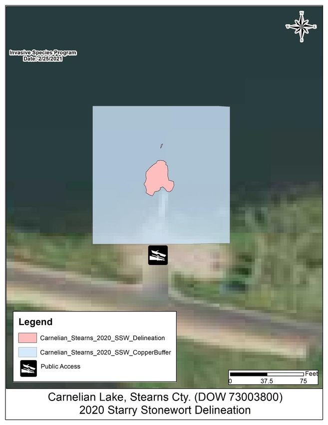
Summary
The purpose of this report is to provide an overview of aquatic plant distribution and the
management of invasive aquatic plants in Carnelian Lake, Stearns County, including the starry
stonewort infestation, monitoring and management efforts that occurred in 2020. This
document summarizes the surveys and management efforts that were coordinated by the MN
DNR, Steve McComas with Blue Water Science and from members of the Carnelian Lake
Association.

Lake Description

Carnelian Lake is a 180 acre lake located three miles north of the town of Kimball in Stearns
County, MN. The maximum depth of water in Lake Carnelian is 36 feet, and 35% of the lake is
classified as littoral (areas of water depth between 0 to 15 feet, where aquatic plants are most
likely to grow). Carnelian Lake has a mean water clarity of 10 feet. Carnelian Lake has a small
watershed (2,950 acres) in which land use consists primarily of agriculture (56%), open water
(14%), hay/pasture (11%), residential (9%), forest (6%) and grassland (4%). A public access is
located on the south side of the lake. A MN DNR aquatic plant survey conducted in 2004,
indicated the lake had up to 37 species of aquatic plants and approximately 40% of the
shoreline contained at least one type of native vegetation with bulrush and yellow waterlily
being the most common.

Invasive aquatic plants

Starry stonewort (Nitellopsis obtusa) was found in Carnelian Lake during the Minnesota Aquatic
Invasive Species Research Center (MAISRC) Starry Trek event on 15 August 2020 (Figure 1). In
2020, as part of the rapid response plan, the population of starry stonewort was delineated
and mapped (Figure 2). On the 18 of August 2020, DNR staff conducted an initial field inspection
by snorkeling and rake sampling to determine the extent of the infestation. The snorkel area
was about 9,000 square feet in front of the public access (Figure 2). During the snorkel search,
observers found one large patch of starry stonewort growth (approximately 690.1 sq. ft.)
within 60 feet from shore and one smaller patch (approximately 2.4 sq. ft.) within the area

Point- intercept Survey and Monitoring Report for Starry Stonewort Management in Carnelian Lake, Stearns
County (2020)
COPYRIGHT MN DNR 2021                                                                               3|P a g e
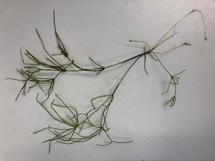
surveyed. Starry stonewort growth extended from shore to 115 feet offshore. Prior to
management, we conducted a pre-treatment survey (21 sampling points within the
management area) to determine the frequency of occurrence of starry stonewort and native
aquatic plants. At this time, 90% of the sampling points had submersed native taxa, totaling 13
species. The most common aquatic plants observed during the initial survey include coontail
(Ceratophyllum demersum), water star-grass (Heteranthera dubia), native stonewort (Nitella
sp.), bladderwort (Utricularia sp.), and Canada waterweed (Elodea canadensis). Overall, the
mean native taxa per a point was 3.1. Of the 21 points, 5% of the points had starry stonewort
which was mostly found at the bottom of the public access ramp. Furthermore, a lake-wide
point-intercept survey conducted on 27 August 2020 further determined its spread was limited
to the access. Observations from both the lake-wide survey and snorkel search indicated that
Carnelian Lake had extensive beds of muskgrass (Chara sp.), which is a starry stonewort look-
alike.

Figure 1 – Starry stonewort (Nitellopsis obtusa) sample collected from Carnelian Lake, Stearns County
(DOW# 73003800) by volunteers during the MAISRC Starry Trek event held on 15 August 2020.

Point- intercept Survey and Monitoring Report for Starry Stonewort Management in Carnelian Lake, Stearns
County (2020)
COPYRIGHT MN DNR 2021                                                                               4|P a g e
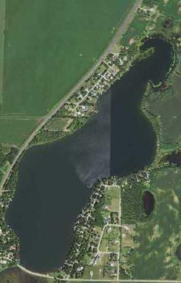
Figure 2 - Initial starry stonewort search summary; approximate perimeter of copper treatment, starry
stonewort location, and the location of the farther known point of starry stonewort growth as of 18
August 2020 in Carnelian Lake, Stearns County (DOW #73003800).

Point- intercept Survey and Monitoring Report for Starry Stonewort Management in Carnelian Lake, Stearns
County (2020)
COPYRIGHT MN DNR 2021                                                                               5|P a g e
Management
Management using both physical removal via scuba divers and a copper treatment of starry
stonewort was conducted in 2020 (Table 1). On 18 September 2020, Bluewater Science scuba
divers physically removed approximately 1,188 pounds of starry stonewort at the public access
(Table 1, Figure 3). Biomass removal estimates were based on wet weight measurements
(Bickel and Perrett 2015) using a digital scale. Once the biomass was weighed, the MNDNR
then bagged the starry stonewort into 40 gallon bags for disposal. The first hand-pulling event
removed the majority of the biomass, although a follow-up copper treatment was used to
destroy the remaining biomass (Table 1). Lake Restoration applied copper to the management
area on 7 October 2020 at a rate of 1.0 PPM. Due to the timing of the treatment, a post-
treatment survey will be conducted in 2021.
Table 1 - Starry Stonewort Management Summary. History of management activities (physical removal
via snorkel and scuba diving) for Carnelian Lake, Stearns County (DOW# 73003800, Total acres: 180,
Littoral acres: 63). Weight rounded to the nearest whole number (pounds).
Approximate
Control amount Licensed Commercial
Date Pesticide Dose Rate
Method (lbs.)/acres Applicator
treated
Steve McComas, Blue
18 Sept 2020 Manual 1,188 lbs. NA NA
Water Science
Cutrine Plus
7 Oct 2020 Pesticide 0.5 acres 1.0 PPM Lake Restoration
(liquid)
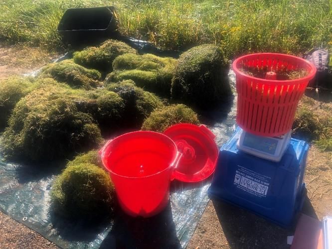
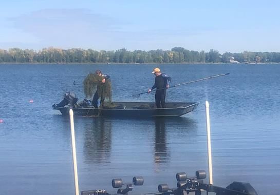
Figure 3 – Starry stonewort (Nitellopsis obtusa) hand pulled from Carnelian Lake, Stearns County
(DOW# 73003800) by Bluewater Science on 18 September 2020.
Point- intercept Survey and Monitoring Report for Starry Stonewort Management in Carnelian Lake, Stearns
County (2020)
COPYRIGHT MN DNR 2021 6|P a g eAquatic Plant Surveys
Methods
A point-intercept survey was conducted on 27 August 2020 using the method developed by
John Madsen in “Aquatic Plant Control Technical Note MI-02, 1999”. A total of 208 sampling
points were placed 60 meters (197 feet) apart using a Geographic Information System (GIS).
The purpose of this survey was to determine the lake wide distribution of starry stonewort and
native aquatic plants (Figure 4). Sampling points were based on depth to rooted vegetation
because of this method, we only surveyed 123 points in depths up to 20 feet (Figure 4). At each
sample point, a double-sided garden rake was thrown and dragged along the lake bottom of
the lake. All plant taxa (submerged, floating-leaf, emergent and free floating) were recorded
during the survey following Crow and Hellquist (2000). Plant samples were assessed on the
boat to determine species and abundance (1: sparse, 2: common/frequent/occasional, 3:
abundant/matted; Table 2) and data was recorded using an electronic device. Frequencies of
occurrence (how often a plant species appeared on a rake) were calculated in depths up to 15
feet.
Table 2- Quantitative rake abundance ranking (0-3) used to estimate plant abundance for each species
based on rake coverage and/or visual observation (MN DNR). A zero (0) ranking indicates no target
plants were retrieved or observed in a sample.
Abundance
Rake Coverage Description
Ranking
1 Sparse; plants covering 75% of the rake head
Point- intercept Survey and Monitoring Report for Starry Stonewort Management in Carnelian Lake, Stearns
County (2020)
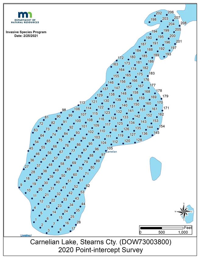
COPYRIGHT MN DNR 2021 7|P a g eFigure 4 - Lake-wide point-intercept survey illustrating locations of the rake toss waypoints within Carnelian Lake, Stearns County (DOW#73003800). Approximately 123 survey points were sampled during the point-intercept survey on 27 August 2020. Point- intercept Survey and Monitoring Report for Starry Stonewort Management in Carnelian Lake, Stearns County (2020) COPYRIGHT MN DNR 2021 8|P a g e
Survey Observations

The most recent aquatic vegetation point-intercept survey of Carnelian Lake (DOW #73003800)
occurred on 27 August 2020. Plants were rooted to a maximum depth (95%) of 15 feet. In the
littoral zone, 96% of the points had submersed native vegetation (Table 3) with a mean
submersed native taxa per point of 2.99. Lake has up to 19 submersed native taxa (Table 3,
Table 4) and one non-native submerged taxa (starry stonewort).

Table 3 - Plant Survey Metrics. Summary of metrics for Carnelian Lake, Stearns County (DOW#
73003800). Shaded values were calculated from littoral depth range.

 Survey Metrics                                                                 8/27/20

 Surveyor                                                                       MN DNR
 Total # Points Sampled                                                            123
 Max Depth of Growth (95%) in feet                                                 15
 # of Vegetated Points in Max Depth Range                                          112
 Max Depth of Starry Stonewort (feet)                                               5
 # Points in Littoral (0-15 feet)                                                  112
 % Points w/ Submersed Native Taxa                                                 96
 Mean Submersed Native Taxa/ Point                                                2.99
 # Submersed Native Taxa                                                           19
 % Points with Starry Stonewort                                                     0
*95th percentile calculated based on all vegetated sampling points
Taxa refers to groups of submersed aquatic plant species or genera

The native plant community in Carnelian Lake Lake was primarily dominated by northern
watermilfoil at 54%, followed by coontail (42%), Richardson's pondweed (36%) and muskgrass
(35%). These aquatic plants are central to a healthy fish population, offering shelter and
providing food and habitat to wildlife. In addition to submersed taxa, the survey also indicated
one floating-leaf taxa (yellow waterlilies), three emergent taxa (bulrush, smartweed and
arrowhead) and one free- floating taxa (star duckweed). Both floating-leaf and emergent plants
are especially good at preventing shoreline erosion, habitat and providing food sources for
waterfowl. Plants also absorb nutrients and reduce algae, thereby improving water quality.

Point- intercept Survey and Monitoring Report for Starry Stonewort Management in Carnelian Lake, Stearns
County (2020)
COPYRIGHT MN DNR 2021                                                                               9|P a g e
Table 4 – Lakewide Plant Frequency Occurrence. Percent frequency of occurrence for submersed taxa (most identified to species) up to 15 feet
in Carnelian Lake, Stearns County (DOW# 73003800). *denotes invasive aquatic plant/algae

Taxonomic Name                               Common Name                                                                 27 Aug 2020
Ceratophyllum demersum                       Coontail                                                                        42
Bidens beckii                                Water marigold                                                                  4
Chara sp.                                    Muskgrass                                                                       35
Elodea canadensis                            Canada waterweed                                                                4
Heteranthera dubia                           Water stargrass                                                                 1
Lemna triscula                               Star duckweed                                                                   3
Myriophyllum sibiricum                       Northern milfoil                                                                54
Najas sp.                                    Naiad species                                                                   4
Nitella sp.                                  Nitella species                                                                 9
Persicaria                                   Water smartweed                                                                 1
Potamogeton freisii                          Fries’ pondweed                                                                 5
Potamogeton gramineus                        Variable pondweed                                                               2
Potamogeton illinoensis                      Illinois pondweed                                                               4
Potamogeton praelongus                       White-stem pondweed                                                             12
Potamogeton richardsonii                     Clasping-leaved pondweed                                                        36
Potamogeton spp.                             Narrow-leaf pondweed group                                                      7
Potamogeton spp.                             Broadleaf pondweed group                                                        1
Potamogeton zosteriformis                    Flat-stemmed pondweed                                                           47
Stuckenia pectinata                          Sago pondweed                                                                   25
Utricularia sp.                              Bladderwort species                                                             6
Nuphar variegate                             Yellow waterlily                                                                4
Potamogeton natans                           Floating-leaf pondweed                                                          3
Saggitaria species                           Arrowhead species                                                               1
Schoenoplectus spp.                          Bulrush species                                                                 13

Point- intercept Survey and Monitoring Report for Starry Stonewort Management in Carnelian Lake, Stearns County (2020)
COPYRIGHT MN DNR 2021                                                                                                                  10 | P a g e
Discussion
Carnelian Lake was the third lake in Minnesota to hand remove starry stonewort via scuba
diving. These recent management efforts have shown to be effective at decreasing the
frequency of occurrence and abundance, in addition, to limiting the spread within the lake.
Because the extent of the infestation, it was practical to physically remove the starry
stonewort. Hand removal via scuba diving is a good option since it has minimal, non-target
effects to native macroalgae and native aquatic plants. This method removes the macroalgae
as well as the attached bulbils. Removing all bulbils during hand-removal, especially in the
sediment, is challenging. Because of the remaining bulbils in sediment, re-growth is likely to
occur. Overall, physical removal has shown to be an effective option for small, isolated
infestations. It is recommended to continue monitoring and managing the infestation to
limited spread and abundance.

Literature Cited
Bickel, T.O and C. Perrett. (2015). Precise determination of aquatic plant wet mass using a salad spinner.
Can. J. Fish. Aquat. Sci., 73 (2015), 1-4pp.

Crow, G.E. and C.B. Hellquist. (2000). Aquatic and wetland plants of Northeastern North America. (Vols.
1 & 2). Madison, WI: The University of Wisconsin Press.

Madsen, J. (1999). Point-intercept and line intercept methods for aquatic macrophytes management.
APCRP Technical Notes Collection (TN APCRP-M1-02). Vicksburg, MS: U.S. Army Engineer Research and
Development Center.

Point- intercept Survey and Monitoring Report for Starry Stonewort Management in Carnelian Lake, Stearns
County (2020)
COPYRIGHT MN DNR 2021                                                                              11 | P a g e
You can also read