Draft Whitianga Coastal Action Plan
←
→
Page content transcription
If your browser does not render page correctly, please read the page content below
Draft Whitianga Coastal Action Plan

                            Draft Whitianga Coastal Action Plan
                                              December 2012
                                                              1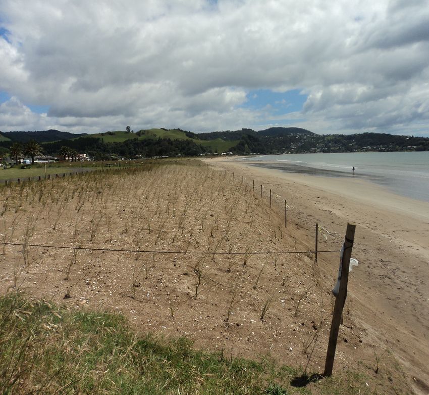
Executive Summary
This plan sets out the comprehensive assessment of the coastal erosion issues facing Whitianga and in
line with the previous reports identifies the foreshore area in distinct areas summarising the current issues
and the long term issues along the length of the foreshore and identifies options and solutions and the
implications of these solutions and cost. Each area of the Whitianga coastal beach front and estuary
requires specific management and along with this there are a number of annual maintenance programmes
for the full beachfront need to be undertaken relating to better stormwater management, sand placement
from dredged sand and boat ramp, wharf and beach maintenance.
It is acknowledged that the accurate cost of the work is on-going and the necessary funding requirements
will continue to be discussed with Council, the Waikato Regional Council, the action committee and the
community through the 10 Year Plan and Annual Plan Process and community engagement.
Summary of Areas A-F
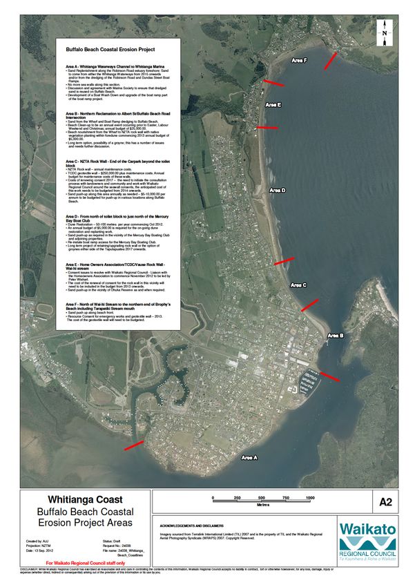
Area A - Whitianga Waterways Channel to Whitianga Marina
Sand Replenishment along the Robinson Road estuary foreshore. The sand may be able to come
from either the Whitianga Waterways from 2015 onwards and/or from the dredging of the Robinson
Road and Dundas Street Boat Ramps and the channel.
No more sea walls along this section
Development of a comprehensive boat ramp strategy including the future options for a Boat Wash
Down and provision of upgrading the existing and new boat ramps.
Building a working relationship with the Whitianga Marina Society and Whitianga Waterways Ltd in
terms of a programme of dredging work and best practices and where possible shared services.
Area B - Northern Reclamation to Albert St/Buffalo Beach Road intersection
Sand from the Wharf and Boat Ramp Dredging reused on Buffalo Beach.
Important public recreation area extensively used throughout the summer months and close to the
wharf and town centre.
Beach Clean-up to be an annual event occurring prior to Easter, Labour Weekend and Christmas
annual budget of $25,000.00
Possibility of beach nourishment from the Wharf to NZTA rock wall with native vegetation planting
within foredune commencing 2013 annual budget of $5,000.00
Draft Whitianga Coastal Action Plan
December 2012
2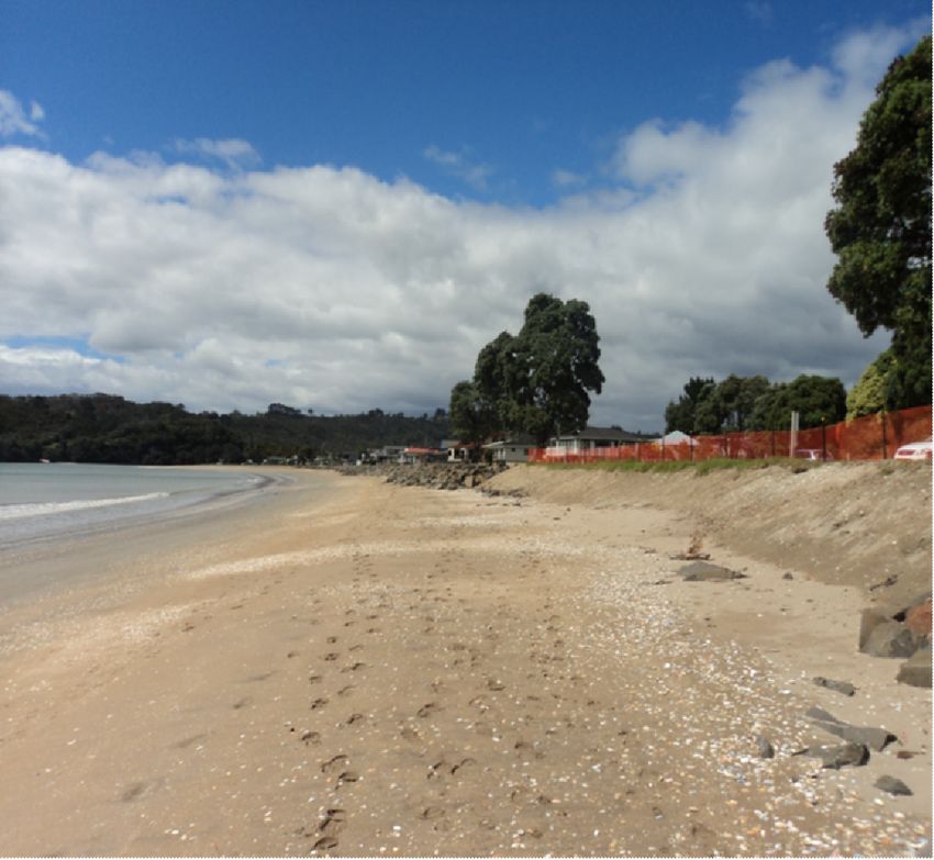
Stormwater strategy for town centre to include options for redirection of the existing stormwater
outlets along this section of beach, this report is to be completed by June 2013.
Wharf maintenance and management to be reviewed.
The long term option needs further discussion and a full study. The 1986 study by Raudkivi
proposed a 220m groyne immediately adjacent to the channel. Further analysis of this option is
required.
Area C - NZTA Rock Wall - End of the Carpark beyond the toilet block
NZTA Rock wall - establish the cost and set a budget for annual maintenance costs.
TCDC geotextile wall - total cost to be approximately $250,000.00 plus maintenance costs. To be
installed in the 2012/13 financial year.
There is a need for the annual budgeting for maintenance costs of these walls.
Rock wall consent renewal due 2017 - There is a need to initiate the consultation process with
landowners and community and work with Waikato Regional Council to confirm the long term
solution. The anticipated cost of this work is to be budgeted from 2014 onwards.
Engage an international consultant in July 2013 to provide the best solution option for this area - a
groyne or intertidal reef or other alternative.
Sand push-up along this area annually as needed - $15,000.00 per annum to be budgeted for push-
up in various locations along the full length of Buffalo Beach.
Area D - From north of toilet block to just north of the Mercury Bay Boat Club
Dune Restoration - the first 70m of dune planting was undertaken in October 2012. In autumn 2013
further planting in this first stage will be undertaken as well as an additional 50m adjoining to the
south and another 50m to the north of the Taputapuatea. This dune restoration planting along
Buffalo Beach is to be a priority during 2013/14.
An annual budget of $5,000.00 is required for the on-going dune restoration and replanting work.
Sand push-up as required in the vicinity of the Mercury Bay Boating Club and adjoining properties.
The boat access for the Mercury Bay Boating Club has been reinstated.
Long term project of retaining/upgrading rock wall or the option of groynes either side of the
Taputapuatea 2017 onwards.
Area E - Home Owners Association/TCDC/Vause Rock Wall - Te Waiti stream
Long term option to be worked through with the landowners, Waikato Regional Council, TCDC, and
Jim Dahm . A meeting is proposed in early January 2013 to discuss and finalise the options and
determine a preferred option and identify the likely cost of work.
Draft Whitianga Coastal Action Plan
December 2012
3 Sand push-up in the vicinity of Ohuka Reserve to continue as and when required.
Area F - North of Te Waiti Stream to the northern end of Brophy's Beach including Tarapatiki
Stream mouth
Important recreation area extensively used throughout the summer.
Sand push up along beach front to be on-going.
Enhancement of beachfront reserve and boat launching.
Resource Consent for emergency works and longer term geotextile backstop wall - the design work
and consent process will be undertaken in 2013. The cost of the geotextile backstop wall will need
to be budgeted.
Consideration of a groyne option to be finalised in the 2013/14 year.
Relocate Council services (pipework) back towards the State Highway.
Draft Whitianga Coastal Action Plan
December 2012
42.0 Introduction
2.1 This document sets out an integrated coastal erosion action plan for Buffalo Beach through to the
Whitianga Waterways Ltd Canal and sets a long term strategy as well as identifying the coastal
erosion work that has been undertaken along Buffalo Beach in recent years and the future on-going
work that is required to ensure that the foreshore areas of Buffalo Beach and the Whitianga estuary
are protected and enhanced to protect the natural coastal character of the sandy beach and
estuarine foreshore. The plan also establishes various actions for the hot spots along the foreshore
that have been subject to coastal erosion over the last 15-20 years and the consent issues that the
Council and various landowners along the beachfront are facing. Also included is an outline of the
annual on-going maintenance, beach clean-up and dredging work that is required each year and
are proposed for inclusion in the Council budgets as we move forward.
2.2 This plan covers the area from the entrance to the Whitianga Waterways Ltd Canal through to the
northern end of Brophy's Beach at Stormont Lane. This area has been divided into six sections with
each section requiring specific consideration and having unique features and issues which together
comprise the whole foreshore area which is a defining character of Whitianga as a coastal
settlement.
2.3 Since 1972 there have been reports undertaken on behalf of the Council and the Waikato Regional
Council to assess coastal erosion at Whitianga and to identify options and ways to manage and
resolve these problems. The reports include:
1972 Simpson;
1973 Gibb;
1979 Environment Waikato;
1981 Healy;
1983 Dell & Higgins;
1986 Ministry of Works;
1986 Raudkivi;
1998 Tonkin & Taylor - Buffalo Beach Coastal Management Strategy;
1999 Buffalo Beach Collaborative Committee on Erosion & Beach Management Problems and
Opportunities;
2003 Terry Healy - Erosion Remediation for Ohuka Beach, Mercury Bay;
2003 Opus - Ohuka Beach, Whitianga Review of Proposed Beach Remediation Works;
2004 Beca - Buffalo Beach Coastal Erosion Management Strategy;
2012 Bronwen Gibberd - Whitianga Coastal Futures - Options for Beach Management.
Draft Whitianga Coastal Action Plan
December 2012
5(Note - this is not a complete list but illustrates the quantum of research and reports that have been
undertaken in relation to coastal erosion and coastal processes.)
All of these reports identify the existing issues of coastal erosion and or coastal processes along
Buffalo Beach and Brophy's/Ohuka Beach and identify various options for the management of the
issues along sections of the beach.
2.4 The purpose of this report is to develop an action plan which encompasses the whole length of the
beach and enables the development of a long term plan which identifies work priorities and sets out
budget requirements and timeframes for solutions to address the problems. The action plan also
includes the annual maintenance programmes along the full length of the beach including the
estuary areas with boat ramps and dredging requirements and areas of beach clean-up to provide
an annual work plan for Council.
3.0 Physical Environment
3.1 In line with the previous reports identified above we have broken the project area into specific
sections Areas A - F.
3.2 Area A Whitianga Waterways Ltd Canal - the Whitianga Marina
The physical environment of this area includes the estuary area which is characterised by the tidal
foreshore areas along Robinson Road, the Robinson Road boat ramp, the boat mooring areas
along the inner harbour and the channel, the Dundas Street boat ramp, the southern reclamation
providing the boat hard stand and boat storage areas and the Whitianga Marina.
Along this area there are opportunities for beach enhancement and replenishment along the
Robinson Road foreshore. Sand dredged from the boat ramp areas and Whitianga Waterways and
the channel may be suitable for beach nourishment along the estuary edge. It is anticipated that it
may be approximately 3-5 years before the Whitianga Waterways Ltd are back into developing new
subdivision areas and this will give Council time to liaise with the community around sand
nourishment along the Robinson Road foreshore areas. It appears that there are some local
residents with very firm views around the option of using dredged sand for beach nourishment. It is
important therefore to identify the residents with a particular interest in this option and discuss the
process with them as part of this plan. Dredged sand is darker than general beach sand however
the sand will bleach to blend in with the existing foreshore sand over a relatively short time period.
There are some old existing seawalls along the Robinson Road foreshore and a number of
structures. It is considered appropriate that no more seawalls be constructed along this area.
Draft Whitianga Coastal Action Plan
December 2012
6The Robinson Road and Dundas Street boat ramps may also require increased maintenance and
dredging. The issue of the Whitianga boat ramps and better provision for boat launching is an
integral component of the management of the foreshore area and foreshore processes. The whole
issue of boat ramps is another project but consideration of these facilities is important in this action
plan. There are a number of issues and options which need separate investigation as part of the
boat ramp discussion. Some of the issues facing the existing facilities are the problems of
congestion around the Esplanade boat ramp and conflict with the public during the visitor summer
peak, the on-going maintenance of all the boat ramps and the inability of the Dundas Street boat
ramp to provide all tide launching and the current at this location making launching difficult. There is
also the future option of providing a facility such as a boat wash-down area in the vicinity of one of
the boat ramp areas and additional boat trailer parking. It is proposed that the issues facing boat
ramps will be investigated as a separate issue from this project but it clearly needs to be undertaken
within the same timeframe and the issues are interrelated. It is proposed that the boat ramp
strategy report be commenced within this current financial year and that the provision for upgrading
the Esplanade boat ramp be completed.
There is also a need for better communication with the Whitianga Marina Society (WMS). The
existing facilities on the southern reclamation are important to the whole community and the Marina
Society is also involved in on-going dredging work. The Marina Society is a very important
component for the coastal foreshore issues. It is important to co-ordinate the use of the dredge and
ensuring a consistent approach to the dredging schedule between WMS, Whitianga Waterways Ltd
and TCDC.
3.3 Area B Northern Reclamation to Albert Street/Buffalo Beach Intersection
This area incorporates the foreshore area immediately adjacent to the Marina through to the
southern end of the NZTA rock wall. The land to the north of the marina is known as the northern
reclamation and provides an open space grassed area, parking and fuel storage associated with the
marina and a public toilet. Carina Creek discharges at this location into the harbour. To the north of
this area is the public boat parking, children's playground, the boat ramp and public toilets and dingy
storage area. This area is a significant area of public open space being located in the town centre
and the site of the annual scallop festival, access to the marina and a key pedestrian area during
the summer months. It is important that this area has good access and high public amenity being an
important component of the upgraded town centre. Running along the front of this area is a
revetment wall which has Waikato Regional Council consent. Around the boat ramp and wharf
there is some need for dredging and this sand can be used along Buffalo Beach.
Draft Whitianga Coastal Action Plan
December 2012
7As identified above the issues of the boat ramp and boat parking area will form part of the overall
boat ramp strategy for Whitianga which is to be undertaken in conjunction with this project. During
the summer months this area is congested. It is proposed to provide better integration of the boat
ramp, boat trailer parking, the children's playground and pedestrian access to and from the wharf.
The draft 2013/14 budget has included $100,000 for the upgrading of the Esplanade Boat ramp. As
part of that work is will be necessary to finalise the most suitable use of public open space between
the boat ramp and the northern reclamation in terms of parking, playground and pedestrian
movement. This project will be a key project for the 2013/14 year.
One option that may help to resolve some of the current boat ramp issues is the possibility of
charging boat users at this central location given its summer demand and the congestion that
occurs. Any money earned from the boat ramp could then be put towards the costs of upgrading
the other boat ramps at Dundas Street and/or Robinson Road and the development of a pontoon at
the Wharf ramp. The WRC consents for dredging and depositing sand expire in 2013 and these
consents need to be renewed.
The wharf is operated as a commercial wharf and utilised daily by the Whitianga Ferry, tour
operators and commercial fisherman, fishing competitions and during the summer months is
constantly busy. There is some maintenance costs associated with the wharf and the Ferry Landing
wharf on the other side of the harbour that need to be budgeted for and Council is currently
reviewing all of the issues associated with the wharf.
The area north of the wharf is the open space foreshore area along the Esplanade this area is one
of the most popular and most utilised areas of Buffalo Beach being a popular area for surf casting
close to the harbour mouth and wharf, pipi gathering, the Banana Boat, beach volleyball and family
gatherings and swimming. This area of beach front is also adjacent to the wharf with all the
pedestrian traffic from the ferry and close to the town centre. This area of beach has naturally
replenished over the last 10-15 years however there is the possibility that the sand currently in this
area will not remain. It is necessary to undertake a feasibility study for the long term options for the
retention of this section of beachfront which is of critical importance to Whitianga. Previous reports
such as the 1998 Tonkin & Taylor report and 2004 Beca report included a number of options
including a possible groyne of between 225 - 125 m long in this area. Such a structure would
however be a significant cost and will alter the natural character of this area of the beach front
including the pipi bank and the groyne may be subject to erosion from the channel. It is therefore
necessary to finalise the suitable long term options for this section of the beach in-conjunction with
the options in relation to the NZTA rock wall.
Draft Whitianga Coastal Action Plan
December 2012
8Some of the other issues along this section of the beachfront are the stormwater outlets from
Buffalo Beach Road and the Esplanade. Council is currently working on a stormwater strategy for
the Whitianga Town Centre as part of the town centre upgrade. Future options for these existing
stormwater outlets are included in that strategy and where possible redirected to Carina Creek or
the harbour rather than discharging to the beachfront (subject to affordability). The stormwater
strategy is to be completed by June 2013 and so this work will be undertaken within the next 6
months.
Beach clean-ups are also proposed to be undertaken annually along this section of the beachfront.
Beach clean-ups will occur between the Wharf and Albert Street (approx. 500m) prior to Labour
Weekend, Christmas and Easter each year.
3.4 Area C- NZTA Rock Wall - End of the Carpark beyond the Toilet Block
This stretch of the beachfront encompasses the New Zealand Transport Agency (NZTA) rock wall
and TCDC geotextile wall. The NZTA rock wall was originally built in the early 1970's and was
recently rebuilt in a jointly funded project between NZTA and TCDC. The rock wall consent expires
on 30 June 2017. The new geotextile wall which is about to be constructed extends northwards
from the end of the NZTA rock wall. This geotextile wall will butt up to the existing NZTA wall and
extend beyond the toilet block and replace an old rock wall immediately in front of the toilet block.
The geotextile rock wall will resolve the on-going issue of end effect erosion from the existing rock
wall between the NZTA wall and the toilets and also erosion occurring immediately north of the toilet
block. The area immediately to the north of the toilets required some work to be undertaken
recently using the emergency provisions of the Resource Management Act 1991.Part of the
construction of the geotextile rock wall will involve re-contouring the beach profile and pushing-up
sand over the geotextile bags. While the geo-textile wall is in effect extending the built coastal
defence structure a further 90 metres along the beach front this section has been subject to
significant erosion. Council will be carefully monitoring the geotextile wall to see if the re-contoured
beach profile can be maintained and it is hoped the on-going need for sand push-up will be reduced.
In the interim along this section of the beach some sand push-up has been undertaken either side of
the toilets to reinstate the beach profile which has been subject to significant recent erosion.
The option of a groyne or intertidal reef needs to be finalised as an alternative to relocating the rock
wall. It is proposed to engage an international consultant to determine a final option for this area of
the beach. One of the issues with the option of an intertidal reef is the strong nearshore tidal current
which will need to be assessed. The alternative to these options is the building of a backstop wall
behind the NZTA wall which would result in a loss of road width. There is a need for consensus
Draft Whitianga Coastal Action Plan
December 2012
9around the preferred options between the community, WRC and TCDC and progressing the
preferred option through the design and consenting process.
3.5 Area D - North of the Toilet Block to north of the Mercury Bay Boat Club
This is a relatively long stretch of the beach and provides a good area for dune restoration and
enhancement. TCDC/WRC have commenced the first part of the dune restoration project which will
involve annually re-contouring and replanting 50-100 metre sections of the dune with appropriate
native coastal plants along this area of beach. The work was undertaken in early October and is a
joint Waikato Regional Council and TCDC project. In autumn 2013 the further planting will be
undertaken with an additional 50m south of the recently planted area and an area of 50m north of
the Taputapuatea stream. An annual budget of approximately $5,000.00 is required for this dune re-
establishment project.
Currently along the southern side of the Taputapuatea stream is a rock wall which has been located
here for a number of years. As identified in the previous reports this rock armouring is successfully
preventing stream migration. From time to time this stream needs realigning and opening to
maintain the flow of water. The Council also has consent for a stop-bank adjacent to the
Taputapuatea stream. The Waikato Regional Council has indicated that a retrospective consent
may be required for the existing rock wall this consent may be able to be incorporated with other
consents along the beach front being undertaken in the near future. Looking towards the longer
term issues it will be necessary to finalise a proposed option and timing to either replace or upgrade
the existing rock wall adjacent to the Taputapuatea with a geotextile wall or consideration of a
groyne at this location. These options will need to be considered from 2017 onwards. This area of
the beachfront is of significance to Ngati Hei with the Taputapuatea stream registered as a site of
Waahi Tapu for Ngati Hei. This area is very popular with young children playing in the stream and
families picnicking. In addition this area is a significant bird nesting area which DOC monitors
during the summer months. Dotterels also nest along the full length of the beach with a number of
pairs either side of the Taputapuatea stream.
Sand push-up along this area of beach at the northern end in the vicinity of the Mercury Bay Boating
Club (MBBC) will be carried out including adjacent to the rock seawall north of the MBBC. This
work is required at various times throughout the year and an annual budget of approximately
$15,000.00 is required for the sand push-up work in various locations along the beach front.
Draft Whitianga Coastal Action Plan
December 2012
10It is also necessary to liaise with the Mercury Bay Boating Club to ensure that there is on-going
communication with them and that there issue of an adequate boat ramp access throughout the
year is resolved.
3.6 Area E - Home Owners Association/ Vause/TCDC Rock Wall - Te Waiti Stream
This section of the beach covers the area of the existing rock walls through to Ohuka Reserve. The
resource consents along this section of the beach expire in September 2015. It is important that
discussions between the Homeowners Association and other key parties included WRC and TCDC
commences in 2012/13. The consultation and renewal of the consent need to be planned for and
how it will be funded agreed. The previous reports have all evaluated the options for this section of
the beachfront and it is a matter for the landowners and other key parties looking towards an agreed
way forward beyond 2015.
In the interim sand push-ups will be carried out along the beach front including in the vicinity of
Ohuka Reserve as and when required.
3.7 Area F - North of Te Waiti Stream through to the northern end of Brophy's Beach
Resource consent from the Waikato Regional Council is required in relation to the emergency works
that were undertaken by the Council earlier in the year placing rocks along the beachfront. This
consent will include the option of replacing the rocks with a geotextile backstop wall covered with
sand and native dune vegetation. This consent process will be commenced in early 2013. The
profile of Brophy's Beach is not as steep as the remainder of Buffalo Beach and therefore the wall is
a relatively low structure. In the interim until a final design solution is established for this section of
beach sand push-up will be on-going to assist in reinstating some high tide beach along this area of
foreshore. The geotextile backstop wall project will be in the order of approximately $500,000.00 -
$750,000.00 and will need to be considered in future budgets beginning with the 2013/14 budget. A
trail area for natural sand skirts will be undertaken on the southern side of the mouth of the
Tarapatiki Stream to see if sand will naturally accumulate around the skirts. This project will be
monitored over the summer and the project has been assisted by the students at Mercury Bay Area
School who have made the sand skirts.
Some matters that need to be addressed at Brophy's Beach to provide long term solutions is the
option of re-diverting the stormwater outlets away from discharging directly to the beach front and
the possibility of a groyne either side of the Tarapatiki Stream.
Draft Whitianga Coastal Action Plan
December 2012
11Brophy's Beach is another extremely important area of the beach front and is a priority area. It is
very popular over the summer months with school groups, families and tourists and the natural
character of this section of the beach is very important along with the open reserve area between
the beach and the road.
4.0 Conclusion
All of the previous reports have identified a range of approaches to coastal hazard management
and beach enhancement. The reports also touch on the national and regional policy statements
which require approaches that recognise the natural forces of the coastal environment. The action
plan has identified where we can establish a programme of dune restoration and beach nourishment
and there are a number of existing consents for dredging and depositing sand and sand push-ups
that can assist with this work programme.
There is a need for a co-ordinated approach between the Waikato Regional Council, TCDC and the
community to move forward together in resolving these very complex coastal issues including
funding options, the consenting requirements, construction and on-going monitoring and
maintenance.
The review of the District Plan will also include the coastal hazard setback which directly affects
portions beachfront properties. The consultation process for the Draft District Plan is underway with
the Proposed District Plan likely to be publicly notified in the middle of 2013.
There are areas along the beachfront that require engineering solutions and there are areas that are
able to retain their natural qualities. The Action Plan is a co-ordinated approach to move forward
and resolve these issues.
Draft Whitianga Coastal Action Plan
December 2012
12Summary Table
Area Solution Timing Cost
Area A
- Foreshore No more seawalls
Enhancement Re use of dredged sand 2015 onwards $10,000.00
2012
- Marina Society Engage in communication Potential for cost
2013 sharing
- Boat Ramp Strategy Identification of upgrading options Costs to be
and new boat ramps determined
Area B
- Beach Nourishment Re use of dredged sand & beach 2013 $5,000.00
& enhancement nourishment
- Boat Ramp Beach Clean-ups X3 annually $25,000.00
Possible charging 2013 Possible cost
savings and
revenue towards
- Wharf boat ramps.
Review of maintenance & 2013 Costs to be
- Stormwater management determined
Management Redirecting stormwater outlets 2015 Likely to be
expensive
Area C
- NZTA Rock Wall Consent issues and long term 2015 Costs to be
options need to be determined determined
- Geotextile Wall Wall to be constructed 2012/13 $250,000.00
- Sand Push-up Annual programme to be 2012/13 $15,000.00 for full
established length of beach
annual cost
Area D
- Dune Restoration 50-100 metres of dune re- 2012 onwards $5,000.00 per year
contouring and planting To be
- MBBC Beach access discussed with
MBBC
Sand push-up
Draft Whitianga Coastal Action Plan
December 2012
13Area E
Seawall Issues Liaison with landowners to Nov 2012 To be determined
commence
Ohuka Reserve Consent issue to be included with
homeowner wall
Sand push-up to continue On-going
Area F
- Protection & Emergency works undertaken 2012 $70,000.00
Enhancement of Geotextile backstop wall 2017 $500,000.00 plus
Brophy's Beach
Draft Whitianga Coastal Action Plan
December 2012
14Draft Whitianga Coastal Action Plan
December 2012
15Draft Whitianga Coastal Action Plan
December 2012
16You can also read