PRE - FEASIBILITY REPORT - Sri. Rakesh Kumar Sahoo At-Mirapatna, PO/PS- Kendrapara
←
→
Page content transcription
If your browser does not render page correctly, please read the page content below
PRE – FEASIBILITY REPORT

  KORUA SAND QUARRY

           Village: Korua,
        Tahasil: Garadapur ,
        District: Kendrapara,
            State: Odisha
      Lease Area – 5.058 Ha

   Screening Category – ‘B2’

    Sri. Rakesh Kumar Sahoo
   At-Mirapatna, PO/PS- Kendrapara,
      Dist-Kendrapara, PIN-754211,
                 Odisha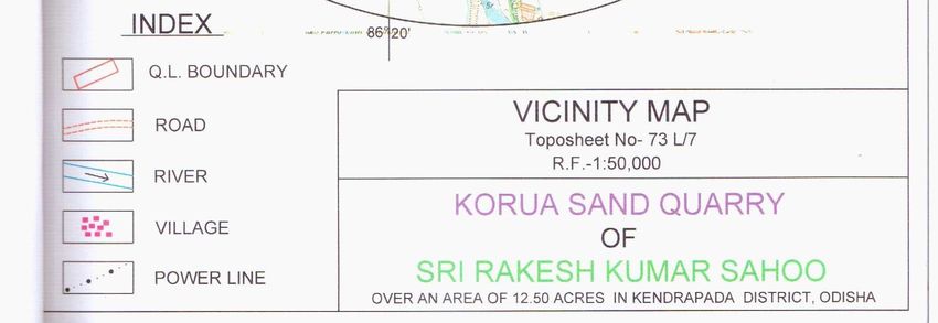
CONTENTS

CHAPTER                    PARTICULARS                         PAGE NO

  01      Introduction of the Project/Background Information     03

  02      Project Description                                    04

  03      Site Analysis                                          08

  04      Planning Brief                                         12

  05      Proposed Infrastructure                                14

          Rehabilitation and Resettlement
  06                                                             16
          ( R & R) Plan

  07      Project Schedule & Cost Estimates                      17

  08      Analysis of Proposal (Final Recommendations)           18

                                                                      2
Chapter -1
Introduction of the Project
1.1 Identification of Project and Project Proponent
The proposed project, Korua Sand Quarry is a sand quarry, which has been given on
long term quarry lease basis to Sri Rakesh Kumar Sahoo in Kendrapara district of
Odisha. In this Sand Quarry mining method is done by manual opencast method and
the proponent is a businessman.
1.2 Brief Description of Nature of Project
Korua sand quarry area is over 12.50acres or 5.058 Ha. in village Korua, Tahasil
Garadapur, District Kendrapara has been allotted to Sri. Rakesh Kumar Sahoo, the
lessee through long term quarry lease basis for quarrying of sand (minor mineral) by
the Tahasildar, Garadapur on behalf of Government of Odisha in accordance with the
provision of the Odisha Minor Mineral Concession (Amendment) Rules, 2014 through
long term quarry lease for the purpose of excavation of sand.
The current allotment through long term quarry lease basis in the name of Sri Rakesh
Kumar Sahoo for five years from 2015-16 to 2019-20.
1.3 Need for the Project and Its Importance to the Country and the
Region
The need and the importance of this Quarry Project are mainly for the construction
infrastructural development of the area. The sand excavated from the quarry is
carried to the domestic market for sale and to be used in construction of house and
road.
1.4 Demand – Supply Gap
There is requirement of total 5000 cu.m of sand. Around 4152 cu.m of sand/annum
will be excavated from Korua Sand quarry and the same will be supplied to the
domestic market. For balance required quantity it may procure from other quarry.
1.5 Imports Vs Indigenous Production
As far as sand production is concerned with reference to the importing of the said
material, it is advantages to mine the mineral rather than importing the same.
1.6 Export Possibility
The excavation of sand is solely for the use in construction of road and buildings in
domestic market.
1.7 Domestic / Export Markets
There is a huge domestic market for the sand. But the purpose of this project is only
use in its local market.
1.8 Employment Generation (Direct and Indirect) due to the
Project
Total number of employment will be around 11 including Management, Supervisory
personnel, Skilled, Semiskilled and Unskilled.
3Chapter - 2
Project Description
2.1 Type of the Project Including Interlinked and Interdependent
Project.
Sand in the quarry lease area is proposed to be mined out by conventional
method of opencast mining through manual operation. The sand excavated from this
quarry will be sold in the local market and used as construction materials for the
development projects of the local area. This is an independent project and not
interlinked with any other project.
2.2 Location (Map Showing General Location, Specific Location
and Project Boundary & Project Site Layout) with Coordinates.
The quarry area is located in north-west of village Korua, under Garadapur Tahasil
of Kendrapara district, Odisha State.
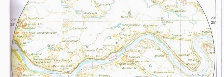
Korua sand quarry area forms a part of Survey of India Toposheet No. 73L/7 The
quarry area bounded between the latitude of 20o23’56.8”N to 20o24’05.9”N and longitudes
of 86o20’39.2”E to 86o20’ 26.0” E. The quarry area is accessible from district head quarter
Kendrapara covering a distance of 55 km. The said quarry area is earmarked in the
Toposheet as shown in the following Map No. – 01.
2.3 Details of Alternate Sites Considered and the Basis of
Selecting the Proposed Site, Particularly the Environmental
considerations gone into should be Highlighted.
Being a Sand Quarry it is site specific. No alternate site can be worked out. It has to
be carried out within quarry area as allotted by the State Government of Odisha as
per the conditions of Odisha Minor Mineral Concession (Amendment) Rules, 2014.
As far as the environmental considerations, the proponent is abiding by all relevant
acts & rule and provisions of EP Act.
2.4 Size or Magnitude of Operation
The size of the quarry area is 12.50acres or 5.058Ha. The magnitude of the
proposed operation is to excavate at an average rate of 4152 cu.m of sand/annum.
45
2.5   Project Description with Process Details (a Schematic Diagram / Flow
      Chart Showing the Project Layout, Components of the Project etc.
      should be given)

Method of Quarrying: Sand in the quarry lease area is proposed to be mined out by
conventional method of opencast mining which will be manual. Because of presence
of soft and incompetent rock mass, drilling and blasting are not required.
Bench Geometry: Benching pattern is not feasible in case of sand mining. The
maximum depth of mining will be of 0.5m.
Time Schedule: Total working days are 210 days in a year. Number of shift per day
is 01 (One). The working hour in a shift is 8.00 hours from 8AM to 2PM and 3PM to
5PM with a lunch break of 1 hour from 2PM to 3 PM

Production Planning: During the plan period the average production will be 4152
cu.m of sand/annum.
Extent of Mechanization: In the Korua sand quarry the operation is manual and
there is no requirement of any machines.
Transportation: The sands excavated from the quarry are transported through 10MT
capacity trucks/dumpers. During transportation overfilling of trucks and consequent
spillage of materials on the roads will be avoided by covering tarpaulin in the loaded
trucks.

List of Machinery/Equipment Proposed: As the mining is manual so no machines
will be used.

Blasting: Korua area is enriched with sand which is soft and incompetent in nature
so no blasting will be required.
2.6   Raw Material Required along with Estimated Quantity, likely
      Source, Marketing Area of Final Product/s, Mode of Transport
      of Raw Material and Finished Product.
The said project is a minor mineral/sand excavation project. It does not involve any
other raw material for sand excavation rather only production of construction sands
from the available reserve within the quarry area.
2.7   Resource Optimization / Recycling and Reuse Envisaged in
      the Project, if any, should be briefly outlined.
Excavation of sand will be carried out strictly as per Odisha Minor Mineral
Concession (Amendment) Rules, 2014 with a view to optimize all resources
available.

2.8   Availability of Water, Its Source, Energy / Power Requirement
      and Source should be given.
2.8.1 Availability of Water and Its Source
Water is used only for drinking purpose. A total 100 liters per day of water is used per
day for the above activities. The water will be purchased from the wells / tube wells
from nearby areas.

                                                                                      6
2.8.2 Energy / Power Requirement and Its Source
No electricity is required as there will be no operation after sun set. For security
purpose if light is required during night then solar power will be arranged for the
same.
2.9 Quantity of Wastes to be generated (Liquid and Solid) and
Scheme for Their Management / Disposal
During plan period the waste generated are the sand mixed with clay which will be
left in the quarry area. Since it is a sand mining so no proposed dump has been
suggested in the quarry as there will be no significant quantity of waste.
Liquid Waste / Waste Water: The said Quarry area does not have any workshop
within the lease area. Thus, no trade effluent is generated from the quarry site.
However, during rainy season surface runoff containing suspended solids and silts
flows out.
2.10 Schematic Representations of the Feasibility drawing which
give information of EIA Purpose.
As per the guide lines of MOEF, GOI vide letter no.J-13012/12/2013-IA-II(I) of
dated 24.12.2013,this prefeasibility report is prepared for Korua sand quarry
(Category-B2) project for grant of environmental clearance. The lease period
is for five years i.e. 2015-16 to 2019-20.
7Chapter – 3
Site Analysis
3.1 Connectivity
The quarry area is located in South east of village Korua, under Garadapur Tahasil
of Kendrapara district in Odisha State.
The quarry area is accessible from district head quarter Kendrapara by covering a
distance of 55 Km by road.
3.2 Land Form, Land Use and Land Ownership
The quarry lease area over 5.058 ha. is Govt. owned non-forest area as per land
schedule of the revenue department as given in below Table No. 01.
Table No. 01
Land Schedule
Area
Village Khata no Plot No Kissam
In Acres In Hectares
Korua 885 3128 Nadi 12.50 5.058
3.3 Topography (Refer Map No. 1)
The area covers a land of 12.50acres or 5.058 Ha.and is located at South east of
village Korua in Kendrapara district of odisha. The area can be featured in Survey of
India Toposheet No. 73L/7. The substantial part of the area represents gently sloping
terrain to almost flat with highest altitude of 10.5mRL towards north-eastern part
where as the south-western part shows the lowest altitude of 9 mRL having an
elevation difference of 1.5m. The general slope is towards north-west.
3.4 Existing Land Use Pattern (Agriculture, Non- Agriculture, Forest, Water
Bodies (including area under CRZ)), shortest distances from the
periphery of the Project to the periphery of the Forest, National Park,
Wild Life Sanctuary, eco-sensitive areas, water bodies (distance from the
HFL of the River), CRZ.
The quarry area over 5.058 hectare is Government owned non-forest area as
per land schedule of the revenue department as given in below Table No. 02
Table No. 02
Land Schedule
Area
Village Khata no Plot No Kissam
In Acres In Hectares
Korua 885 3128 Nadi 12.50 5.058
The land use of the quarry site is quarry only including temporary road.
8Distance of Various Physical Features from the Boundary of the Lease Area
There is no such Ecologically Sensitive area as per Hon’ble Supreme Court
Civil writ petition No.460 of 2004.
There is no national park/wild life sanctuary/biosphere reserve/ tiger reserve/
elephant reserve in the lease area and buffer zone (10.0 km radius of the
quarry area).
There is no seasonal or perennial nala in the quarry area.
There is no endangered fauna like elephant, sloth bear, python etc in & around
the Quarry area.
3.5 Existing Infrastructure
Location of the Quarry Lease area with respect to the infrastructure is given as
follows:
Table No. 03
Existing Infrastructure
Sl. No. Important Place Station Distance (km)
1 Bus Stop Korua 1
2 Railway Station Cuttack 55
3 Hospital Korua 1
4 High School Korua 1
5 College Korua 1
6 Post Office Korua 1
7 Police Station Korua 1
3.6 Soil Classification and Geology both Regional & Local
Regional Geology :
Geologically, the Lease area belongs to Quaternary deposit from Holocene period
which located in the Luna River bed in Korua of Tahasil- Garadapur h, District-
Kendrapara. The quaternaries overlie directly on the Tertiaries and are composed of
younger and older alluvia. The sediments of older alluvia are grayish to brownish in
colour, unfossilferous, but contain calcareous concretions. Thin younger alluvial
9deposits of recent age are found in the flood plains and by the side of the river. They
also consist of sand, silt, clay and gravel.
Local Geology:
The sand deposit in Luna River near Korua belongs to recent deposits of Holocene age.
Beach sand, younger and older alluvium also belongs to the same age. The auction area
is occupied by a gently sloping to almost flat deposits of sand. The basement consists of
Tertiary deposits and only sand is encountered in the area.
3.7 Climate Data from Secondary Sources
Climate of the Kendrapara which is located at 20 kms from the quarry site can be
taken as a reference to describe the climate of the Quarry Site. Kendrapara District
enjoys quite moderate or temperate climate. In other words, summers are bearably
hot, so is the cold during winter and even rainfall recorded here is just above
moderate. During summer season temperature can rise up to 42°C, while during
winter season temperature can slip to 12°C. As for rainfall during monsoon season is
concerned, then it is around 1498mm per year. The driest month is December, with 6
mm of rainfall. The greatest amount of precipitation occurs in August, with an
average of 333 mm.
3.8 Social Infrastructure Available
Accessibility: The quarry area is accessible by all weather & well-connected by road
and rail. The quarry site is connected through 80kms from state head quarter
Bhubaneswar and 20 Km long road from Kendrapara district head quarter. The
nearest railway station is Cuttack which is located at a distance 55km from the
quarry area.
Market Facility: Market is at Korua which is located at a distance of 1 km from the
quarry site.
Water availability: Water supply for the Quarry including drinking is made available
from existing bore well from Korua village
Medical & Educational Facilities: Medical facilities are available at Korua at a
distance of 1Kms from the quarry area. High School for educational facilities is
10available at Ashureswar at a distance of 1km; Govt. College is situated at Korua at a
distance of 1kms.
Postal & Telephonic facilities: Postal and telephonic facilities are available at
Korua.
11Chapter – 4
Planning Brief
4.1 Planning Concept (type of industries, facilities, transportation
etc.) Town and Country Planning / Development Authority
Classification
The said proposal is a sand quarry. The Lessee does not have any plan for
construction of town ship for its employees. Mostly local villagers are employed. They
are commuting from local areas. Public and self transport facilities are used for
commuting from their residence to the Quarry site.
4.2 Population Projection
There is no human settlement in the Quarry area. People of the buffer zone are
mostly engaged in business and agriculture.
4.3 Plantation Program
Afforestation and Reclamation/Rehabilitation: There is no forest growth in the
quarry site. Plantation in sand bed is not sustainable. The worked out area will be
reclaimed/rehabilitated naturally every year during rainy season .The river will carry
sand and sediments which will eventually filled in pits. No further reclamation
proposal is required by way of plantation in the following manner after the reserve is
completely exhausted.
4.4 Assessment of Infrastructure Demand (Physical & Social)
No new infrastructures will be constructed to handle the proposed production.
Existing facilities are adequate.
124.5 Amenities / Facilities
Accessibility: The quarry area is accessible by all weather & well-connected by
road and rail. The quarry site is connected through 80kms from state head quarter
Bhubaneswar and 20 Km long road from Kendrapara district head quarter. The
nearest railway station is Cuttack which is located at a distance 55km from the
quarry area.
Market Facility: Market is at Korua which is located at a distance of 1 km from the
quarry site.
Water availability: Water supply for the Quarry including drinking is made available
from existing bore well from Korua village
Medical & Educational Facilities: Medical facilities are available at Korua at a
distance of 1Kms from the quarry area. High School for educational facilities is
available at Ashureswar at a distance of 1km; Govt. College is situated at Korua at a
distance of 1kms.
Postal & Telephonic facilities: Postal and telephonic facilities are available at
Korua.
Facilities at Site:
First-aid facilities equipped with sterilized dressing materials such as cotton wool,
bandages, iodine and antiseptic solution etc for treatment of the quarry workers
before hospitalization, if any accident occurs in the quarry.
Rest shed is provided at the quarry site to take food & water and rest during lunch
time.
Site office is used for day to day quarry administration and management.
13Chapter – 5
Proposed Infrastructure
5.1 Industrial Area the Processing Area
It is an excavation of Sand quarry project. Area around 5.058 Ha will be used for
excavation. The detail of land use of area is given as below:
Table No. 04
LAND USE
Sl. Type of Land Use Area in Hectares
No.
At Present At the end of Plan
(Existing) Period
1 Area under excavation 1.375 4.360
2 Road 0.076 0.076
3 Safety zone. 0.675 0.675
4 Unutilized land 3.109 0.124
Total 5.058 5.058
5.2 Residential Area (Non – Processing Area)
No residential facilities envisaged in the project.
5.3 Social Infrastructure
Accessibility: The quarry area is accessible by all weather & well-connected by
road and rail. The quarry site is connected through 80kms from state head quarter
Bhubaneswar and 20 Km long road from Kendrapara district head quarter. The
nearest railway station is Cuttack which is located at a distance 55km from the
quarry area.
Market Facility: Market is at Korua which is located at a distance of 1 km from the
quarry site.
Water availability: Water supply for the Quarry including drinking is made available
from existing bore well from Korua village
Medical & Educational Facilities: Medical facilities are available at Korua at a
distance of 1Kms from the quarry area. High School for educational facilities is
available at Ashureswar at a distance of 1km; Govt. College is situated at Korua at a
distance of 1kms.
Postal & Telephonic facilities: Postal and telephonic facilities are available at
Korua.
14Facilities at Site:
First-aid facilities equipped with sterilized dressing materials such as cotton wool,
bandages, iodine and antiseptic solution etc for treatment of the quarry workers
before hospitalization, if any accident occurs in the quarry.
Rest shed is provided at the quarry site to take food & water and rest during lunch
time.
Site office is used for day to day quarry administration and management.
So no social infrastructures are required for this Quarry.
5.4 Connectivity (Traffic and Transportation Road / Rail / Metro /
Waterways etc.)
The quarry area is accessible by all weather roads and well-connected by road and
rail. The quarry site is connected through 80kms road from state head quarter
Bhubaneswar & 20kms long road from district head quarter Kendrapara. The nearest
railway station is Gorakhnath which is located at a distance 55km from the quarry
area.
5.5 Drinking Water management (Source & Supply of Water).
Water is used only for drinking, portable use, dust suppression and plantation. A total
100 liters of water is used per day for the above activities. The water is made
available from bore wells available in quarry area.
5.6 Sewerage System
No residential facilities envisaged in the project. Quarry is operating only in single
shift. So no sewerage system is required in this quarry area.
5.7 Industrial Waste Management
There is no industrial waste from the quarry site.
5.8 Solid Waste Management
During plan period the waste generation is nil.
5.9 Power Requirement & Supply / Source
No electricity required at quarry site.
15Chapter – 6
Rehabilitation and Resettlement (R & R Plan)
6.1 Policy to be adopted (Central / State) in respect of the project
affected person including Home Oustees, Land Oustees and
Land Less Laborers (a Brief Out line to be given)
The Quarry area is over 5.058 ha. is Govt. owned non-forest area as per land
schedule of the revenue department and the kissam is Nadi.
There is no human settlement with in the quarry area. People of the buffer zone are
mostly engaged in business and agriculture.
R & R Policy of Govt. of Odisha will not be required as there is no human settlement
within the quarry area.
16Chapter – 7
Project Schedule & Cost Estimate
7.1 Likely date of Start of Construction and Likely Date of
Completion.
For the financial year 2015-16 to 2019-20, it is allotted to Sri. Rakesh Kumar Sahoo
through long term quarry lease process. The commencement of production is after
obtaining environmental clearance. The excavated construction sand will be
completely used in the domestic market.
7.2 Estimated Project Cost along with Analysis in terms of
Economic Viability of the Project.
The approximate cost of the project is comes round Rs 4.5lakhs.
17Chapter - 8
Analysis of Proposal: Final Recommendations
8.1 Financial and Social Benefits with Special Emphasis on the
Benefit to the Local People including Tribal Population, if
any, in the area.
As the project is to excavate ordinary river sand and which will be utilized as road
and building construction material, it brings improvements in the physical and social
infrastructures in the area definitely to some extent, apart from providing direct
employment, contractual employment and indirectly employment and mostly from the
local community due to Sand Mining.
Tangible Benefits:
Local community near the quarry area finds good employment potential in the
quarry directly and in ancillary activities indirectly.
The Sand mining operations also result in financial gains for the state and
central exchangers, through collection of various taxes like royalty, welfare cess
and central excise.
Improvement of the general living standard of the people in the vicinity to some
extent.
Growth of allied industries in the area to some extent.
8.2 Recommendation for EC
The said sand quarry project is less than 25.00 Ha. and it is categorized as category
B2 project as per office Memorandum no: J-13012/12/2013-IA II(I), dtd. 24.12.2013 of
Government of India, Ministry of Environment and Forests, New Delhi (Annexure – 1)
Hence issuance of environmental clearance by SEIAA Bhubaneswar may kindly be
considered.
(Rakesh Kumar Sahoo)
At-Mirapatana, PO/PS- Kendrapara
Dist- Kendrapara
PIN-754211 (Odisha)
18You can also read