ANATS FY 2017-2022 Anderson Area Transportation Study Transportation Improvement Plan - www.cityofandersonsc.com
←
→
Page content transcription
If your browser does not render page correctly, please read the page content below
Anderson Area Transportation Study
             ANATS

 Transportation Improvement Plan
          FY 2017-2022

          www.cityofandersonsc.com
Table of Contents

Introduction                                              1

Process                                                   2

Products                                                  3

Funding                                                   4

Certification                                             6

Financial Statement                                       7

Guideshare Projects                                       8

       Multi-Use Path                                     9
       SC 24 @ Old Asbury Road                           10
       Concord Road@ Cathey/Harris Bridge Road           11
       Brown Road @ Kings Road                           12
       S. Main @ Campbell/Broyles/Dean                   13
       SC 187@ Whitehall Rd. Ext.                        14
       Monroe Street @ Market Street                     15
       Concord Road @ N. Main/Whitehall                  16
       Quinn @ Railroad                                  17
       Whitner @ I Street                                18
       Midway Road @ Harriet Circle                      19
       Midway Road @ Crestview Road                      20
       Anderson Street @ Zion Street                     21
       South Main Street @ Shockley Ferry/Lewis Street   22

Transportation Alternatives Program                      23

       Jackson Street Sidewalk- Phase 2                  24

SCDOT Safety Projects within ANATS                       25

       SC-28, Abbeville Highway                          26
       I-85 SB Ramp @ West SC-178                        27
       S-34 (Whitehall Road) @ Sullivan Road             28

SCDOT Resurfacing and Pavement Preservation              29

Active Projects Map                                      30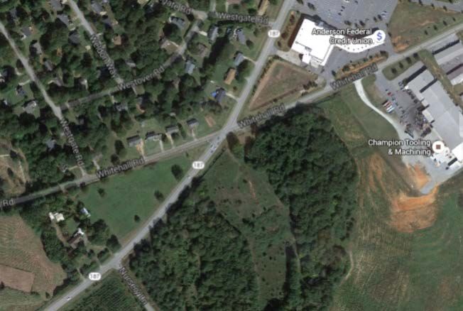
Introduction

The Anderson Area Transportation Study (ANATS) is the Metropolitan Planning
Organization (MPO) for the Anderson urbanized area. ANATS serves the Cities of
Anderson and Belton along with the portions of Anderson County encompassed by the
study area.

Federal Highway Administration (FHWA) and Federal Transit Administration (FTA)
regulations require all urbanized areas with populations of 50,000 or more to create an
MPO. Each MPO must develop a cooperative, comprehensive, and continuing
transportation planning process in order to qualify for Federal funding for transportation
projects.

Three major products developed by ANATS are a Transportation Improvement Plan
(TIP), a Long Range Transportation Plan (LRTP), a Unified Planning Work Program
(UPWP). Opportunities for public input are advertised and public comments are actively
solicited for each of these planning documents.

The TIP is a short-range program that schedules projects to be funded in the next six
years, and indicates project priorities. Projects move from the LRTP to the TIP based on
the priorities established in the LRTP. The TIP includes only those projects for which
funding is available, and a project cannot be included in the TIP unless it is in the LRTP.
The TIP draws projects from all of the various components of the LRTP and schedules
them for implementation.

When projects are added to the TIP, they are prioritized based on area-wide needs.
Project priorities result from the placement of the project in the long-range plan, funding
availability, and the scheduling requirements of the state and federal governments.
Highway projects are included in the TIP to reflect activities ranging from pre-
construction activities, right of way acquisition, and construction. Transit projects also
are included to reflect planning, operating expenses, and capital funds. Most large
projects are funded in phases over several years, while smaller projects may be fully
funded in a single year in the TIP. Regardless of schedule, a project must be included in
the TIP in order to be eligible for funding. When a project advances to the TIP, initial
planning for the project has been completed and implementation begins.

                                             1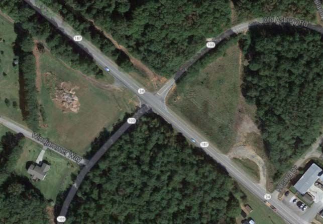
Process

ANATS is composed of a Policy Committee and a Study Team

The Policy Committee is the body granting final approval to all plans, projects and
funding. The Policy Committee consists of 15 voting members; 10 elected officials; 4
county residents; and 1 SCDOT District Commissioner. Below the policy committee is
listed:

              REPRESENTATION                               NAME
       City of Anderson (Mayor)                       Terence Roberts
       City of Anderson (Council)                       Steve Kirven
       City of Anderson ((Council)                     Don Chapman
       Anderson County Council                        Francis Crowder
       Anderson County Council                          Gracie Floyd
       City of Belton                                 Marion Nickles
       Legislative Delegation                          Kevin Bryant
       Legislative Delegation                           Anne Thayer
       Legislative Delegation                           Brian White
       S.C. Department of Transportation                 Ben Davis
       Anderson County Planning
       Commission                                       Jane Jones
       County Resident                                 Ray Fretwell
       County Resident                                     open
       County Resident                                 Mike Buckner
       County Resident                                 Loyd Wilson

The Study Team develops and reviews planning documents, projects, and plans, and
makes recommendations to the Policy Committee. The Study Team consists of the
technical staff from city and county governments. Staff from other resource agencies --
including the S.C. Department of Health and Environmental Control Bureau of Air
Quality, and the U.S. Environmental Protection Agency – is involved in Study Team
meetings on an as-needed basis.

                                            2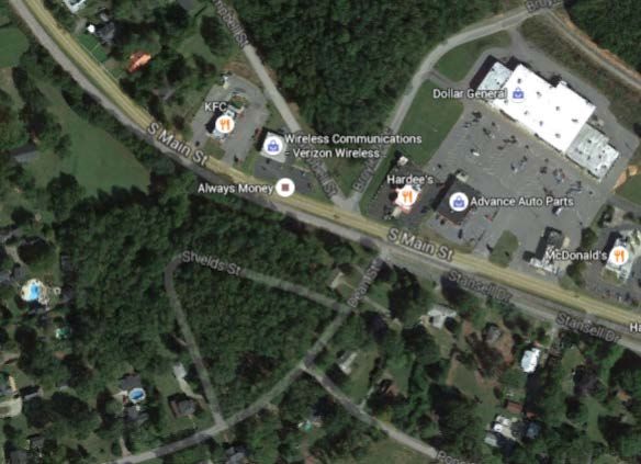
Products

Transportation Improvement Plan (TIP)

The TIP is developed every two years, and allows local and state officials to set
priorities for spending federal highway and transit funds available to the ANATS region.
The TIP is developed cooperatively with South Carolina Department of Transportation.
Projects cannot be placed in the TIP unless they are first included in the LRTP. Once the
TIP is approval by the ANATS Policy Committee and the South Carolina Transportation
Commission, the TIP is submitted to FHWA and FTA for review.

The priority of the projects in the TIP is established through consultation between the
Study Team and Policy Committee. The Study Team ranks projects based on mobility
and accessibility needs, safety and security, economic and community vitality,
environmental protection, improved connectivity among transportation modes, efficient
system management, and maintenance and preservation of the transportation
infrastructure. The Policy Committee may adjust and modify the Study Team
recommendations based on policy considerations and available funding.

Once approved, the TIP may be amended by the ANATS Policy Committee at any
scheduled meeting. Administrative changes can be made on the staff level as needed.

Long Range Transportation Plan (LRTP)

The LRTP describes the policies, strategies, and facilities proposed for construction in the
metropolitan planning area during the next 25 years. The LRTP recommends
transportation projects that will provide for the transportation needs of the area. The plan
includes a listing of all transportation projects that can be built with the federal, state, and
local funding that is expected to be available.

The LRTP includes highway construction projects, congestion management projects,
freight-related projects, public transportation projects, and bicycle and pedestrian
projects. Projects are evaluated and ranked based on mobility and accessibility needs,
safety and security, economic and community vitality, environmental protection,
improved connectivity among transportation modes, efficient system management, and
maintenance and preservation of the transportation infrastructure.

Unified Planning Work Program (UPWP)

The UPWP is the element of the planning process that identifies the planning activities to
be completed by ANATS staff and outside consultants. All planning activities must be
listed in the UPWP to be eligible for funding. The ANATS UPWP is updated annually.

                                               3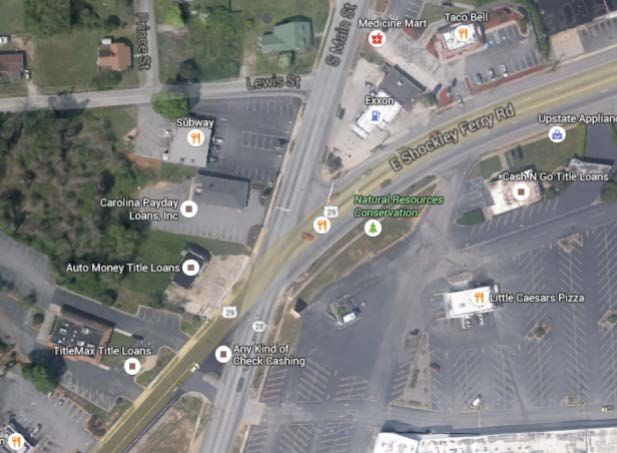
Public Involvement

ANATS follows a Public Involvement Plan that details the approach, values, and
activities that are followed to ensure full and effective public participation in the planning
process. A variety of methods are used to solicit public input, including small group
presentations, news releases, distribution of printed and electronic newsletters, surveys,
public workshops, development of corridor studies and area plans, and public hearings.
The TIP is made available to the public for comment for a minimum of 15 days prior to
being adopted.

                                          Funding

ANATS projects are funded through federal and state transportation funds.

Guideshare Funds

Funds for road improvements are allocated by SCDOT through the Guideshare Program.
The S.C. Transportation Commission sets aside approximately $114 million dollars of
FHWA and SCDOT funds each year and distributes the money among the state’s ten
MPOs and Councils of Governments based on population and vehicle miles of travel in
each region. The Guideshare sets the annual budget for highway improvements within
each MPO or COG, and total project costs in any given year normally cannot exceed the
Guideshare apportionment.

Road improvements may include constructing new roads, adding traffic lanes to existing
roads, constructing paved shoulders, installing traffic signals, constructing sidewalks or
bike lanes, or making safety improvements. Major maintenance improvements may also
be included, such as resurfacing a road. However, minor maintenance activities such as
patching potholes are not funded through ANATS, but are handled directly by SCDOT
maintenance units.

ANATS apportionment from the Guideshare Program is $2.8 million annually. Of this
amount, approximately $1.2 million per year is devoted to debt service. SCDOT
developed an innovative financing plan in 1998 to accelerate construction of many
projects that were built between 1998 and 2007, and issued bonds to fund the plan. Debt
service payments will continue though 2022 to retire the bonds that were issued to fund
the accelerated construction program.

Transportation Alternatives Program (TAP)

The FAST Act continues the TAP program began in MAP-21. MAP-21 established a
new program to provide for a variety of alternative transportation projects, including
many that were previously eligible activities under separately funded programs. The TAP
replaces the funding from pre-MAP-21 programs including Transportation
Enhancements, Recreational Trails, Safe Routes to School, and several other
discretionary programs, wrapping them into a single funding source. Due to ANATS

                                              4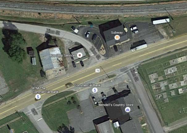
being classified as small urban, all TAP projects submitted will be awarded on a
statewide competitive basis, administered by SCDOT.

Eligible TAP Activities

   •   Construction, planning, and design of on-road and off-road trail facilities for
       pedestrians, bicyclists, and other nonmotorized forms of transportation.
   •   Construction, planning, and design of infrastructure-related projects and systems
       that will provide safe routes for non-drivers, including children, older adults, and
       individuals with disabilities to access daily needs.
   •   Conversion and use of abandoned railroad corridors for trails for pedestrians,
       bicyclists, or other nonmotorized transportation users.
   •   Construction of turnouts, overlooks, and viewing areas.
   •   Community improvement activities, including—
           o inventory, control, or removal of outdoor advertising;
           o historic preservation and rehabilitation of historic transportation facilities;
           o vegetation management practices in transportation rights-of-way to
               improve roadway safety, prevent against invasive species, and provide
               erosion control; and
           o archaeological activities relating to impacts from implementation of a
               transportation project eligible under 23 USC.
   •   Any environmental mitigation activity, including pollution prevention and
       pollution abatement activities and mitigation to—
           o address stormwater management, control, and water pollution prevention
               or abatement related to highway construction or due to highway runoff; or
           o reduce vehicle-caused wildlife mortality or to restore and maintain
               connectivity among terrestrial or aquatic habitats.

In addition to defined Transportation Alternatives (as described above), the

   •   The recreational trails program under 23 USC 206.
   •   The safe routes to school program under §1404 of SAFETEA–LU.
   •   Planning, designing, or constructing boulevards and other roadways largely in the
       right-of-way of former Interstate System routes or other divided highways.

Federal Transit Administration Projects

Federal Transit Administration (FTA) funds are allocated based on urbanized areas.
Urban funding is available in Section 5307, which can be used for capital (e.g.
purchasing buses, bus stop shelters, construction of facilities) and some maintenance
activities. The ANATS Urbanized Areas can also use 5307 funds to cover up to 50
percent of the net operating expenses of the transit system. Large Urbanized Areas are
not allowed to spend 5307 funds on operating expenses.

                                             5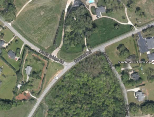
Section 5303 funds can be used only for planning activities, which may include salaries
for staff planners or consultant studies.

                                      Certification

An annual self-certification process, which certifies that the planning process complies
with federal requirements, is included in the UPWP, which is adopted bi-annually.

                                            6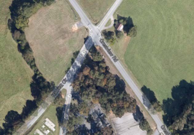
ANATS FINANCIAL STATEMENT
(COST IN THOUSANDS)
TIP REMAINING
FY FY FY FY FY FY FY FY COST COST
PIN # PRIORITY GUIDESHARE PROJECTS 2015 2016 2017 2018 2019 2020 2021 2022 (2014-2022) (2022+) FUNDING
1 Multi-Use Path $400 R $1,000 C $1,400
2 SC 24 @ Old Asbury Rd $1,200 C $1,400
3 Concord Rd @ Cathey/Harris Bridge Rd $1,750 C $2,200
4 Brown Road @ Kings Road $250 R $1,750 C $2,000
5 S Main @ Campbell/Broyles/Dean (Belton) $400 R $1,750 C $2,150
6 SC 187 @ Whitehall Rd Extension $500 R $1,200 C $1,700
7 Monroe Street @ Market Street $200 R $1,750 C $1,950
8 Concord Rd @ N Main/Whitehall $100 R $500 C $600
9 Quinn @ Rail Road $200 P $250 R $860 C $1,310
10 Whitner St @ I St $200 P $250 R $1,020 C $1,470
11 Midway Road @ Harriet Cir $200 P $200 R $1,030 C $1,430
12 Midway Road @ Crestview Rd $150 P $100 R $640 C $890
13 Anderson St @ Zion St (Belton) $200 P $250 R $530 C $980
14 S Main @ Shockley Ferry/Lewis St $300 P $250 R $550 940 C
GUIDESHARE PAYBACK
DEBT SERVICES $1,047 $1,032 $1,015 $998 $981 $638 $644 $7,299 $2,258
GUIDESHARE SUBTOTALS $4,797 $4,032 $2,765 $1,698 $4,681 $1,738 $3,824 $2,200 $27,329 $2,258
GUIDESHARE ALLOCATION 2,750 2,815 2,815 2,815 2,815 2,815 2,815 2,815 $22,455
CARRYOVER AVAILABLE 4,472 2,425 1,208 1,258 2,375 509 1,586 577 $2,375
GUIDESHARE ADVANCEMENT
GUIDESHARE SUBTOTALS (4,797) (4,032) (2,765) ($1,698) ($4,681) ($1,738) ($3,824) ($2,200) ($19,311)
BALANCE 2,425 1,208 1,258 2,375 509 1,586 577 1,192
TRANSPORTATION ALTERNATIVE PROJECTS
JACKSON STREET SIDEWALK PHASE 2 STP
(ANDERSON COUNTY) 400 C TOTAL- 400
MATCH- 80
SAFETY PROGRAM (EXEMPT FROM GUIDESHARE)
SC-28 (ABBEVILLE CO. LINE TO HOOPER DR) 2,416 C 5,940 HSIP/STP
I-85 SB RAMP @ West SC-178 675 HSIP
S-34 (WHITEHALL ROAD) @ SULLIVAN ROAD 100 C 970 C 1,320 HSIP
S-49 (Flat Rock Road MM0 to MM 9.26) 2,500 C 2,500 HSIP
EXEMPT SUBTOTAL $2,516 $3,470 $10,435
RESURFACING (EXEMPT FROM GUIDESHARE)
SC 28 (.03 W L-1285 (Hooper Dr) to SC 28 Bus) 0 HSIP
US 178 (I-85 Bridge to .57 Mi S S-667 (Manse Jolly Rd)) 0 HSIP
EXEMPT SUBTOTAL
PAVEMENT PRESERVATION (EXEMPT FROM GUIDESHARE)
S-22 (SC 28 Bypass to S-111 (S Gossett St)) 0 HSIP
S-34 (SC 28 Bus (Whitehall Rd) to S-333 (Concord Ave)) 0 HSIP
S-111 (US 76 (E River St) to S-331 (Old Williamston Rd)) 0 HSIP
S-263 (US 29 (Shockley Ferry Rd) to US 76 (E River St)) HSIP
S-333 (S-34 (Concord Rd) to SC 28 Bus (N. Main St)) 0 HSIP
S-472 (US 76 (Forest Hill Dr) to S-71 (Rogers St)) 0 HSIP
SC 28 (SC 28 Bus (S. Main St) to SC 24 (W Whitner St)) 0 HSIP
SC 28 (S-1165 (S Main St) to US 28 Bus (S Murray Ave)) HSIP
US 29 (GA State Line to .02 SW SC 81 (S Murray Ave)) 0 HSIP
US 76 (S-256 (Phil Watson Rd) to SC 28 Bus (Whitehall Rd)) 0 HSIP
EXEMPT SUBTOTAL
FEDERAL TRANSIT ADMINISTRATION
ELECTRIC CITY TRANSIT 750 OP $700 OP $750 OP $750 OP $750 OP $750 OP $750 OP $750 OP $5,950 FTA 5307
ELECTRIC CITY TRANSIT $400 CA $400 FTA 5307
CITY OF ANDERSON PLANNING DIVISION 25 PL 25 PL 25 PL $25 PL $25 PL $25 PL $25 PL $25 PL $200 FTA 5303
KEY: P - PRELIMINARY ENGINEERING, R - RIGHT OF WAY, C - CONSTRUCTION, CA - CAPITAL PURCHASE, OP - OPERATING, PL - PLANNING, VA - VEHICLE ACQUISITION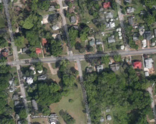
GUIDESHARE PROGRAM

The Statewide Transportation Improvement Program (STIP) adopted by the SCDOT
Commission in July 2006 allocated $2,207,000 annually to ANATS. Since then the
guideshare allocation has seen some change, raising to $2,724,875 and with MAP-21
falling to $2,541,000. Fiscal year 2015 saw ANATS guideshare allocation climb to
$2,815,237 only to be reduced to 2,749,956 due to the federal penalty for the structure of
Emma’s Law. The annual debt service for the 1997 Project Acceleration Program will
vary slightly from year to year, but is approximately $1.1 million.

                             ANATS Guideshare Projects

   1. Multi-Use Path
   2. SC 24 @ Old Asbury Road
   3. Concord Road@ Cathey/Harris Bridge Road
   4. Brown Road @ Kings Road
   5. S. Main @ Campbell/Broyles/Dean
   6. SC 187@ Whitehall Rd. Ext.
   7. Monroe Street @ Market Street
   8. Concord Road @ N. Main/Whitehall
   9. Quinn @ Railroad
   10. Whitner Street @ I Street
   11. Midway Road @ Harriet Circle
   12. Midway Road @ Crestview Road
   13. Anderson Street @ Zion Street
   14. South Main Street @ Shockley Ferry/Lewis Street

                                            8
Anderson Area Transportation Study
Transportation Improvement Plan
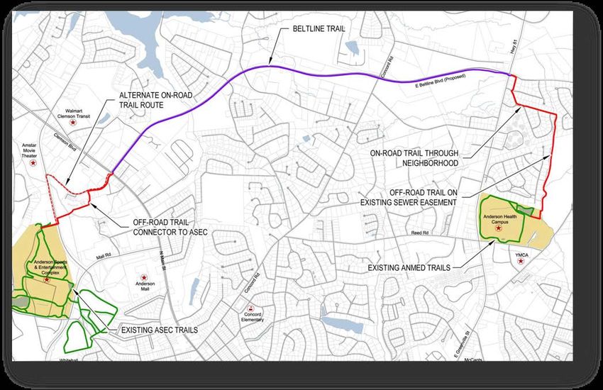
Project: Multi-Use Path
Total Cost (thousands): $3,500
Description: A ten foot multi use path running north/west across Clemson Blvd to the
Civic Center and south along Hwy 81 connecting to the ANMED Health Campus.
Purpose: Offer transportation options and improve air quality.
County, City: Anderson, None
Program Type: Guideshare
Funding Source: Surface Transportation Program
Comments: This project extends the guideshare funded multi-use path currently being
constructed in conjunction with the East-West Connector.
Estimated Unobligated Costs in Thousands
Activity FY 2014 FY 2015 FY 2016 FY 2017 FY 2018 FY 2019 FY 2020 TIP Cost
PE
ROW 1,000 1000
CONST 1,350 850 2,200
TOTAL 1,000 1,350 850 3,200
9Project: SC 24 @ Old Asbury Road
Total Cost (thousands): $1,600
Description: Widen approach on Old Asbury, provide turning lanes and widen SC 24 to
provide turn lanes.
Purpose: Relieve congestion and increase both flow and safety.
County, City: Anderson, None
Program Type: Guideshare
Funding Source: Surface Transportation Program
Comments:
Estimated Unobligated Costs in Thousands
Activity FY 2016 FY 2017 FY 2018 FY 2019 FY 2020 FY 2021 FY 2022 TIP Cost
PE
ROW
CONST
TOTAL 0
10Project: Concord Road @ Cathey/Harris Bridge Road
Total Cost (thousands): $2,300
Description: Realign Cathay Road with Harris Bridge Road, widen approaches with turn
lanes in each quadrant. Add Signal if needed.
Purpose: Relieve congestion and increase both flow and safety.
County, City: Anderson, None
Program Type: Guideshare
Funding Source: Surface Transportation Program
Comments:
Estimated Unobligated Costs in Thousands
Activity FY 2016 FY 2017 FY 2018 FY 2019 FY 2020 FY 2021 FY 2022 TIP Cost
PE
ROW
CONST
TOTAL 0
11Project: Brown Road @ Kings Road
Total Cost (thousands): $2,250
Description: Address a congestion issue via roundabout.
Purpose: Relieve congestion and increase both flow and safety.
County, City: Anderson, None
Program Type: Guideshare
Funding Source: Surface Transportation Program
Comments:
Estimated Unobligated Costs in Thousands
Activity FY 2016 FY 2017 FY 2018 FY 2019 FY 2020 FY 2021 FY 2022 TIP Cost
PE
ROW 250 250
CONST 1,750 1,750
TOTAL 250 1,750 2,000
12Project: South Main @ Campbell/Broyles/Dean
Total Cost (thousands): $2,150
Description: Intersection upgrade to address safety concerns.
Purpose: Relieve congestion and increase both flow and safety.
County, City: Anderson, Belton
Program Type: Guideshare
Funding Source: Surface Transportation Program
Comments:
Estimated Unobligated Costs in Thousands
Activity FY 2016 FY 2017 FY 2018 FY 2019 FY 2020 FY 2021 FY 2022 TIP Cost
PE
ROW 400 400
CONST 1,750 1,750
TOTAL 400 1,750 2,150
13Project: SC 187 @ Whitehall Road Extension
Total Cost (thousands): $1,700
Description: Improve radii and widen approaches to provide turn lanes.
Purpose: Relieve congestion and increase both flow and safety.
County, City: Anderson, None
Program Type: Guideshare
Funding Source: Surface Transportation Program
Comments:
Estimated Unobligated Costs in Thousands
Activity FY 2016 FY 2017 FY 2018 FY 2019 FY 2020 FY 2021 FY 2022 TIP Cost
PE
ROW 500 500
CONST 1,200 1,200
TOTAL 500 1,200 1,700
14Project: Monroe Street @ Market Street
Total Cost (thousands): $2,000
Description: Realign Southwood Road with Monroe Street and widen approaches for
turn lanes in each quadrant.
Purpose: Relieve congestion and increase both flow and safety.
County, City: Anderson, Anderson
Program Type: Guideshare
Funding Source: Surface Transportation Program
Comments:
Estimated Unobligated Costs in Thousands
Activity FY 2016 FY 2017 FY 2018 FY 2019 FY 2020 FY 2021 FY 2022 TIP Cost
PE
ROW 200 250
CONST 1,750 1,750
TOTAL 200 1,750 2,000
15Project: Concord Road @ N. Main/Whitehall
Total Cost (thousands): $800
Description Improve the turning radius, turning right from Concord Rd onto North Main
Street.
Purpose: Relieve congestion and increase both flow and safety.
County, City: Anderson, Anderson
Program Type: Guideshare
Funding Source: Surface Transportation Program
Comments: This project was moved to the 10th ranked project due to issues found in the
preliminary engineering phase. It is currently being reevaluated.
Estimated Unobligated Costs in Thousands
Activity FY 2016 FY 2017 FY 2018 FY 2019 FY 2020 FY 2021 FY 2022 TIP Cost
PE
ROW 100 100
CONST 500 500
TOTAL 100 500 600
16Project: Quinn @ Railroad
Total Cost (thousands): $1,310
Description: Realign and upgrade the intersection
Purpose: Relieve congestion and increase both flow and safety.
County, City: Anderson, Anderson
Program Type: Guideshare
Funding Source: Surface Transportation Program
Comments:
Estimated Unobligated Costs in Thousands
Activity FY 2016 FY 2017 FY 2018 FY 2019 FY 2020 FY 2021 FY 2022 TIP Cost
PE 200 200
ROW 250 250
CONST 860 860
TOTAL 200 250 860 1,310
17Project: Whitner @ I Street
Total Cost (thousands): 1,470
Description: Realign and upgrade the intersection
Purpose: Relieve congestion and increase both flow and safety.
County, City: Anderson, Anderson
Program Type: Guideshare
Funding Source: Surface Transportation Program
Comments:
Estimated Unobligated Costs in Thousands
Activity FY 2016 FY 2017 FY 2018 FY 2019 FY 2020 FY 2021 FY 2022 TIP Cost
PE 200 200
ROW 250 250
CONST 1,020 1,020
TOTAL 200 250 1,020 1,470
18Project: Midway Road @ Harriet Circle
Total Cost (thousands): 1,430
Description: Create T intersection or incorporate with Crestview intersection
improvement
Purpose: Relieve congestion and increase both flow and safety.
County, City: Anderson, None
Program Type: Guideshare
Funding Source: Surface Transportation Program
Comments:
Estimated Unobligated Costs in Thousands
Activity FY 2016 FY 2017 FY 2018 FY 2019 FY 2020 FY 2021 FY 2022 TIP Cost
PE 200 200
ROW 200 200
CONST 1,030 1,030
TOTAL 200 200 1,030 1,430
19Project: Midway Road @ Crestview Road
Total Cost (thousands): 890
Description: Upgrade the intersection
Purpose: Relieve congestion and increase both flow and safety.
County, City: Anderson, None
Program Type: Guideshare
Funding Source: Surface Transportation Program
Comments:
Estimated Unobligated Costs in Thousands
Activity FY 2016 FY 2017 FY 2018 FY 2019 FY 2020 FY 2021 FY 2022 TIP Cost
PE 150 150
ROW 200 200
CONST 640 640
TOTAL 150 200 640 890
20Project: Anderson Street @ Zion Street
Total Cost (thousands): 980
Description: Realign and upgrade the intersection
Purpose: Relieve congestion and increase both flow and safety.
County, City: Anderson, Belton
Program Type: Guideshare
Funding Source: Surface Transportation Program
Comments:
Estimated Unobligated Costs in Thousands
Activity FY 2016 FY 2017 FY 2018 FY 2019 FY 2020 FY 2021 FY 2022 TIP Cost
PE 200 200
ROW 250 250
CONST 530 530
TOTAL 200 250 530 980
21Project: South Main Street @ Shockley Ferry/Lewis Street
Total Cost (thousands): 1,490
Description: Realign and upgrade the intersection
Purpose: Relieve congestion and increase both flow and safety.
County, City: Anderson, Anderson
Program Type: Guideshare
Funding Source: Surface Transportation Program
Comments:
Estimated Unobligated Costs in Thousands
Activity FY 2016 FY 2017 FY 2018 FY 2019 FY 2020 FY 2021 FY 2022 TIP Cost
PE 300 300
ROW 250 250
CONST
TOTAL 300 250 550
22TRANSPORTATION ALTERNATIVES PROGRAM
The Transportation Alternatives Program (TAP) was created by MAP-21 (and continues
in the FAST Act) provide for a variety of alternative transportation projects, including
many that were previously eligible activities under separately funded programs.
ANATS Transportation Enhancement Projects
1. Jackson Street Sidewalk- Phase 2
23Project: Jackson Street Sidewalk- Phase 2
Total Cost (thousands): $400
Description: This project will add sidewalks along Jackson Street from Boyce Street to
Westside High School.
Purpose: Enhance the safety of the pedestrian network in the ANATS Study Area.
County, City: Anderson
Program Type: TAP
Funding Source: Surface Transportation Program
Comments:
Estimated Unobligated Costs in Thousands
Activity FY 2016 FY 2017 FY 2018 FY 2019 FY 2020 FY 2021 FY 2022 TIP Cost
PE
ROW
CONST 400
TOTAL 400
24SCDOT SAFETY PROJECTS WITHIN ANATS
SCDOT Safety Projects are guideshare exempt projects designed to improve the utility of
the transportation network by improving current conditions creating a safer travel
environment for all users.
SCDOT Safety Projects Within ANATS
1. SC-28, Abbeville Highway
2. I-85 SB Ramp @ West SC-178
3. S-34 (Whitehall Road) @ Sullivan Road
25Project: SC-28, Abbeville Highway
Total Cost (thousands): $5,940
Description: This project spans from the Abbeville County Line to Hooper Drive. This
project will provide additional pavement for shoulder widening and rumble stripes, select
clearing, guardrail additions and upgrades, and signing and marking upgrades.
Purpose: Enhance safety.
County, City: Anderson
Program Type: Safety
Funding Source: HSIP/STP
Comments:
Estimated Unobligated Costs in Thousands
Activity FY 2016 FY 2017 FY 2018 FY 2019 FY 2020 FY 2021 FY 2022 TIP Cost
PE
ROW
CONST
TOTAL
26Project: I-85 SB Ramp @ West SC-178
Total Cost (thousands): $675
Description: This project is an intersection improvement to the southbound exit ramp
from I-85 to West SC-178.
Purpose: Enhance safety
County, City: Anderson
Program Type: Safety
Funding Source: HSIP
Comments:
Estimated Unobligated Costs in Thousands
Activity FY 2016 FY 2017 FY 2018 FY 2019 FY 2020 FY 2021 FY 2022 TIP Cost
PE
ROW
CONST
TOTAL
27Project: S-34 (Whitehall Road) @ Sullivan Road
Total Cost (thousands): $1,320
Description: This project will improve the intersection of Whitehall Road at Sullivan
Road.
Purpose: Enhance the safety of intersection.
County, City: Anderson
Program Type: Safety
Funding Source: HSIP
Comments:
Estimated Unobligated Costs in Thousands
Activity FY 2016 FY 2017 FY 2018 FY 2019 FY 2020 FY 2021 FY 2022 TIP Cost
PE
ROW
CONST 970 970
TOTAL 970 970
28SCDOT RESURFACING AND PAVEMENT
PRESERVATION WITHIN ANATS
SCDOT resurfacing and pavement preservation projects are guideshare exempt and
designed to improve the utility of the transportation network by improving current
conditions creating a safer travel environment for all users.
SCDOT Resurfacing Projects within ANATS
1. SC-28 (.03 W L-1285 (Hooper Dr) to SC 28 Bus)
2. US 178 (I-85 Bridge to .57 Mi S S-667 (Manse Jolly Rd))
SCDOT Pavement Preservation Projects within ANATS
1. S-22 (SC 28 Bypass to S-111 (S Gossett St))
2. S-34 (SC 28 Bus (Whitehall Rd) to S-333 (Concord Ave))
3. S-111 (US 76 (E River St) to S-331 (Old Williamston Rd))
4. S-263 (US 29 (Shockley Ferry Rd) to US 76 (E River St))
5. S-333 (S-34 (Concord Rd) to SC 28 Bus (N. Main St))
6. S-472 (US 76 (Forest Hill Dr) to S-71 (Rogers St))
7. SC 28 (SC 28 Bus (S. Main St) to SC 24 (W Whitner St))
8. SC 28 (S-1165 (S Main St) to US 28 Bus (S Murray Ave))
9. US 29 (Georgia State Line to .02 SW SC 81 (S Murray Ave))
10. US 76 (S-256 (Phil Watson Rd) to SC 28 Bus (Whitehall Rd))
29Anderson Area Transportation Study (ANATS)
Active Projects
2017-2022
_
^
_
^
Symbol Guideshare Projects
Multi-Use Path Project
SC 24 @ Old Asbury
Concord Rd @ Cathey/Harris Bridge Rd
Brown Rd @ Kings Road
S. Main @ Campbell/Broyle/Dean
SC 187 @ Whitehall Rd Ext.
W. Market St @ Monroe/Southwood St
Concord Rd @ N. Main/Whitehall Rd
Quinn @ Rail Road
Legend
Whitner @ I Street
Resurfacing
Safety Project Midway Rd @ Harriet Cir
Pavement Preservation Midway Rd @ Crestview Rd
ANATS Study Area Anderson St @ Zion St
Major Roads S. Main @ Shockley Ferry/Lewis St
Streets
Safety Pojects
Municipal Boundaries
Lakes
± ^
_
_
^
I-85 SB Ramp @ West SC-178
Whitehall Rd @ Sullivan RdYou can also read