Drones in the Arctic Geomorphic change detection using unmanned aerial vehicles (UAVs) - Aleksandra Tomczyk Marek Ewertowski ...
←
→
Page content transcription
If your browser does not render page correctly, please read the page content below
Drones in the Arctic

 Geomorphic change detection
using unmanned aerial vehicles
           (UAVs)

            Aleksandra Tomczyk
              alto@amu.edu.pl

             Marek Ewertowski
       marek.ewertowski@gmail.com

Faculty of Geographical and Geological Sciences
         Adam Mickiewicz University
                Poznań, Poland
Who we are?
We are geomorphologists interested in landscape dynamics in
mountain and polar areas in multiple temporal and spatial scales.
Drones have been used by us for different projects since 2013.
Our experience from using drones:
Several projects related among other to: quantification of debris flows
activities, landslides dynamics, alluvial and colluvial fans morphology and dynamics,
mapping of proglacial areas, glacier mass balance, ice velocity, cliffs
morphodynamics, soil erosion, vegetation mapping, creation of 3D models of
buildings
Countries where we flown: Norway (Svalbard), Iceland, Greenland, UK, Poland,
New Zealand, Peru, Colombia
Drones which we have (and use most often) - DJI quadcopters: Phantom 2
Vision+, Phantom 3 Advanced, Phantom 4 Pro; Mavic Pro Platinum
We also used sporadically other models: quadcopters - Inspire, S1000, S800, F550;
fixed-wing - SmartPlane SmartOne
Both of us have valid UAV operator license for VLOS as well as BVLOS
operations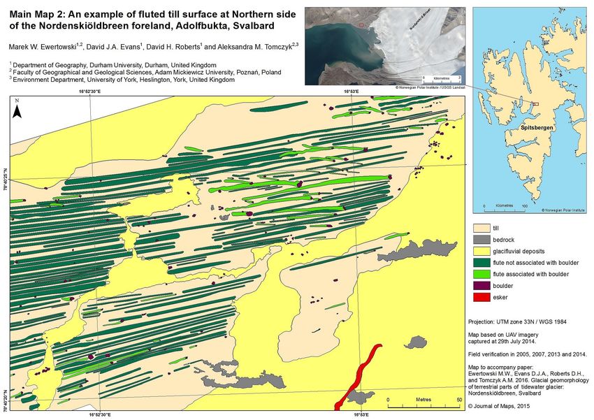
How did we decide what type of drone will be good for us?
Our general aim is to monitor short-term landscape dynamics, i.e. we
create time-series of digital elevation models and orthomosaics to see
landscape changes
Conditions:
We would like to monitor short-term dynamics (daily, monthly, annually)
Our study sites are relatively small (up to 2 km sq.)
Most of our sites involved some (or more than some) hiking
Sky is usually clouded – the light is not good for taking pictures
It can be cold, windy and rainy
Therefore, we were looking for something (perfect solution):
Small and light (to put it into the backpack together with some other stuff)
Able to take pictures in low-light conditions
Characterised by relatively long flying time
Able to operate in close to 0oC condition
Easy to use and reliable
Able to withstand winds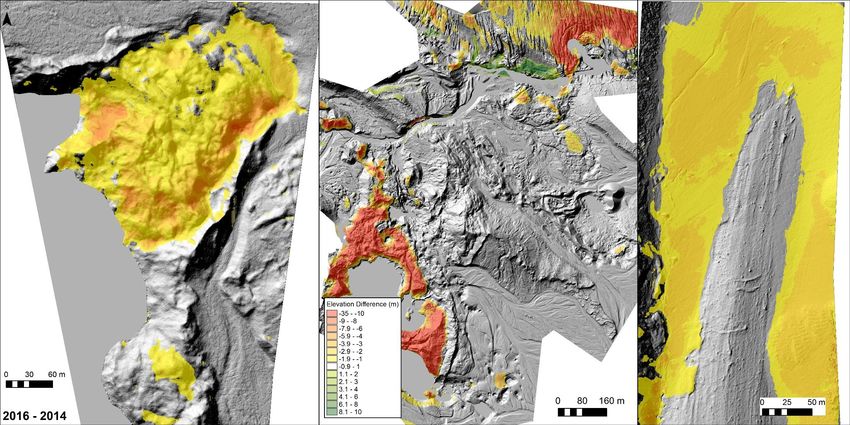
Why did we choose small ‘ready-to-fly’ quadcopters?
We tried different solutions:
Large quadcopters (DJI S1000, S800) – they were simply too large to transport
them.
fixed-wing plane SmartOne SmartPlane (used during 2014 Iceland campaign –
surveys of proglacial areas):
PROS CONS
Efficiency – large area can be covered in one The metal case was extremely inconvenient to
flight carry in the field
Working (and easy) GCS – operator needs only Very hard to find proper landing spot (at least
to select the areas of interest and software will on Iceland)
calculate photo positions
Images’ coordinates can be retrieved by aerial Photos were blurred or noised, especially in
mapper software and use for further weak light condition
processing
No issues with taking photos Price
No problem with GPS signal
smartplanes.se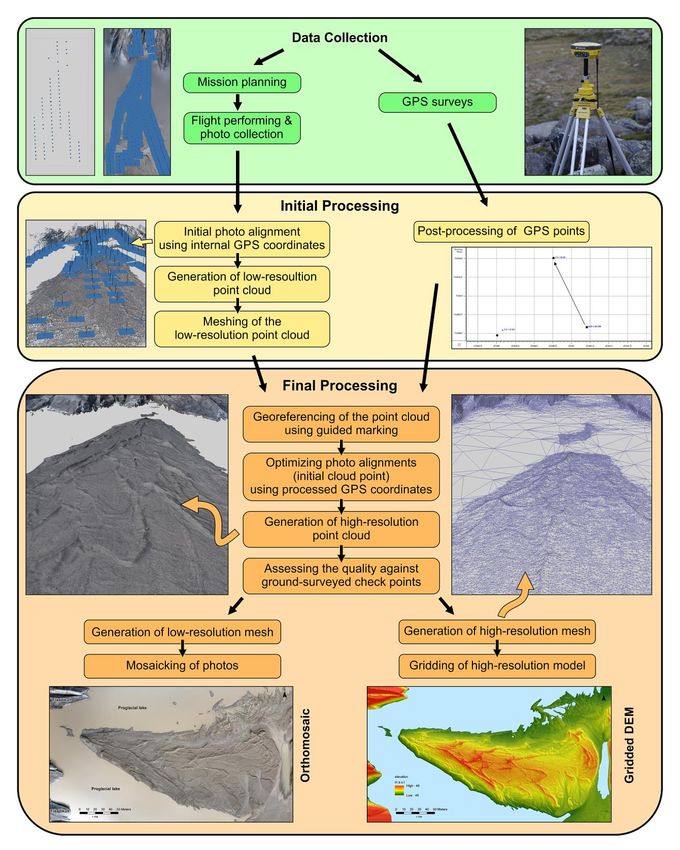
Why did we choose small ‘ready-to-fly’ quadcopters?
Finally we decided to use DJI quadcopters: Phantom 2 (2014, 2015);
Phantom 3 Advanced (2016, 2017); Phantom 4 Pro (2017); Mavic Pro
Platinum (2018) mainly due to:
stabilization: ability to hoover over one spot + 3-axis gimbal = sharp pictures even
in low light conditions (clouded sky and 1/20 or less shutter speed)
Light and compact – they fit into large photographic backpack = easy transport
within study area
Small footprint (less than 50cm) – it is possibly to take-off from almost any kind
of terrain (including boulder surface of the moraine)
Easy to pilot and relatively cheap
Some cons:
Relatively short flying times (however, newer models are much better, increase
from 18-20 min (P2) to 25-27 mins (P4 and Mavic)
Sometimes issues with application
Mobility was a key for us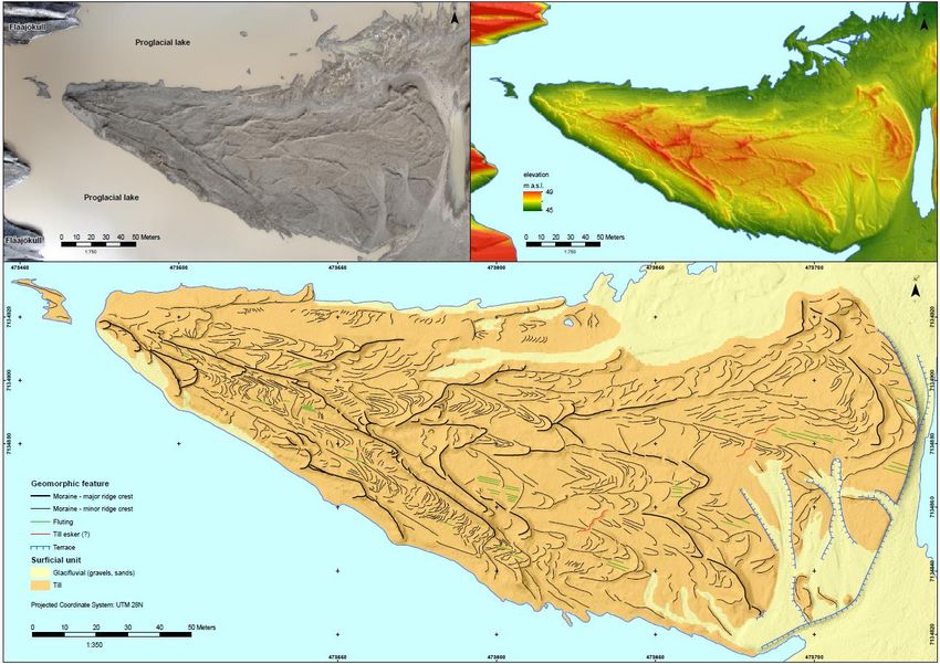
Our approach (step-by-step): Stage I – preparation
Check national and local regulation – in some countries (e.g. Morocco, Thailand) drones are not
allowed
Register (if necessary) with Civil Aviation Authorities – (1) we passed exams for UAV operators in
Poland (both VLOS and BVLOS), (2) registered as RO1 operator in Norway (VLOS); registered and
marked our drones to operate them in the USA
Ask for permission (if needed) from National Park managers and/or local authorities and owners –
we asked for permission from Vatnajokull National Park authorities, The Governor of Svalbard,
Ministry of Transport and Communications in Peru, Station managers etc.
Prepare all necessary paperwork: operation manuals, flight procedures - in some countries it is
obligatory (e.g. Poland) in other voluntary, but it is good to prepare such documents for our own
sake.
Purchase insurance
Upgrade all kit (drone, controller, batteries, application) – it is much easier to do it in a warm place
with good internet connection than in the field!
Double check if everything works, perform test flights etc.
Check transit countries regulations (e.g. in Thailand drone had to stay at the airport).
Check airlines regulations:
In general drone can be taken on board if it fits into hand luggage
LIPO batteries are not allowed in checked-in luggage, so they must be taken on-board: < 100 Wh –
unlimited; 100-160 Wh - two per passenger; >160 Wh (large drones like S1000 use them) – not allowed at
all; must be shipped separately using special courier service. However, some airlines have their own
regulations, e.g. Avianca limits ALL LIPO batteries
Stage II – travel, airport security, etc.
One option is to check-in drone as additional luggage (or put it into luggage
if it fits) – we did it several times in the past using hard (metal or plastic)
cases and our drones survived air travel without incident.
Recently, we usually have taken drone on-board, just in case our checked-in
lugged get lost somewhere (and it happened to us several times). We use
dedicated backpack for Phantom (which can fit drone, spare batteries,
normal DSLR camera and laptop) or large photographic backpack for Mavic
and other stuff.
We usually travel with 1 or 2 drones, 8 to 16 batteries, and dGPS distributed
in hand-luggage of two or three people (with the exception to South
America fieldtrips with Avianca, where we only can take 5 batteries – 4
spares (2 per person) and one in the drone).
So far, we have never encountered any problems during Airport security or
border control check (Poland, UK, Norway, Iceland, Greenland, China, USA,
New Zealand, Colombia, Peru). We have travelled with drone(s) with the
following airlines:
Air China; Airberlin (before it bankrupt); American Airlines; Avianca (allows only 2
batteries per passenger); British Airways; China Eastern; Copa Airlines; Icelandair; LOT;
Lufthansa; Norwegian; SAS; Thai Airways; Wizzair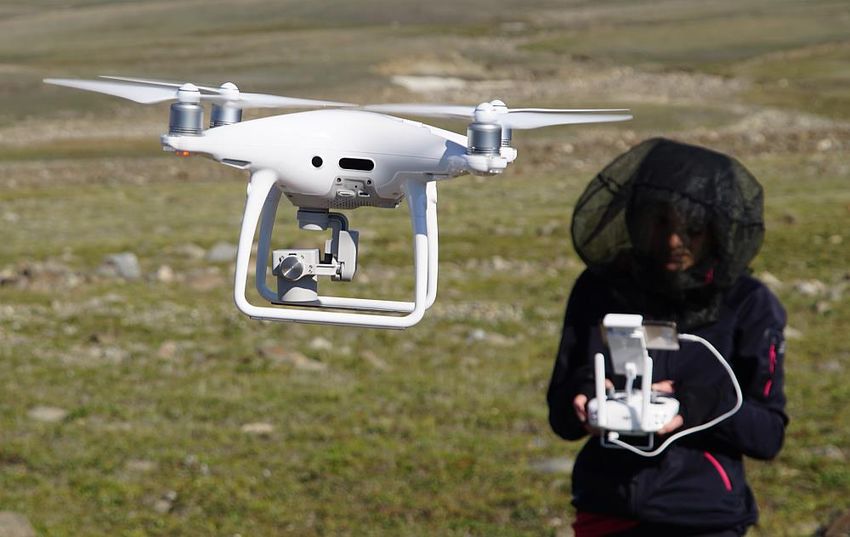
Stage III: Take-off preparation
Contact airport towers/local authorities/owners etc – e.g. for operations near
Longyearbyen we called LYR airport tower before each survey session; in
Zackenberg, Greenland we asked station manager if any other flying activities are
planned
Take a proper look of the area we are going to survey:
Any obstacles which potentially can block line of sight or radio signal
Andy obstacles like trees or electric wires (not a common problem in the arctic but often a
nightmare in Colombia)
Avoid concrete surfaces and object (they can contain metal parts which will interfere with
drone magnetometer
Choose place for take-off from which offers us as much visibility as possible
Prepare all equipment: remove gimbal protection, mount propellers, connect
phone/tablet with remote controller (RC), check if the drone has not been damaged
during transport
Turn-on RC and THAN drone
Check the sensors (accelerometer, magnetometer, gyroscope etc.), if they behave in
a normal way - sometimes it was necessary to calibrate compass; especially when
we flew in a new place (in case of Phantom 2 we did it everyday).
Check the app settings – Return-to-home (RTH) altitude should be set-up higher
than the highest obstacles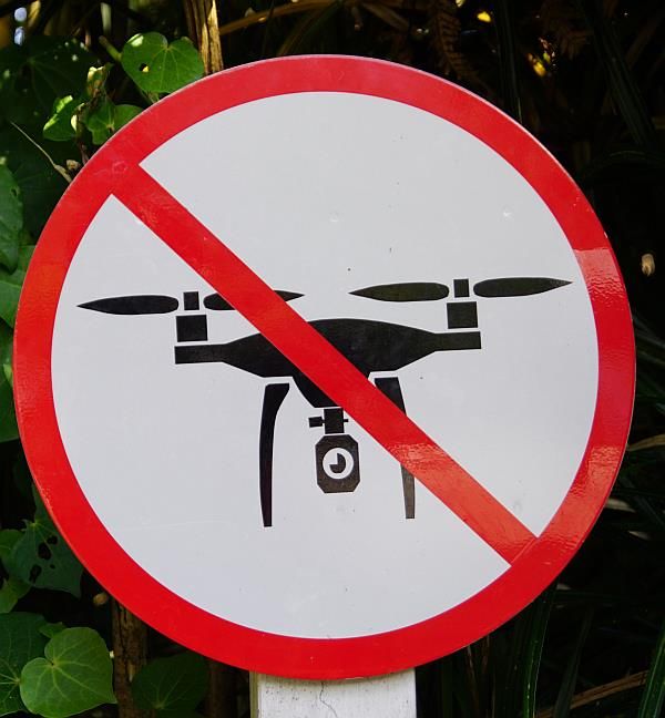
Stage IV: Take-off, surveys, landing (1)
Take-off and hoover for a while at about 5 m above the ground, pull the
drone forward/backward left/right, rotate it rapidly - if the drone responds
in a normal way we are ready to go; if not it is necessary to land and check
what is wrong
We usually fly in GPS mode, but without mission planning – we fly in straight
lines (using ‘course lock’ function), taking vertical photos manually with high
overlap (80-90%). It might seem unnecessary, but in case of damaged/blurred
photos it helps a lot during processing.
If the studied site is characterised by steep/near vertical fragments (e.g. cliff,
landslide, building) we are also take slant, sometimes even horizontal photos
to ensure that all surfaces will be covered by images.
When the battery level reaches 30% we return and land. Then, change the
battery and repeat the previous steps.
We usually operate as a team – one of us is a pilot (responsible for flying
and taking pictures), the other one is observer (trying to keep visual contact
with drone for all time). We switch roles every one or two batteries.
Sometimes, we are using two drones at the same time adding an extra
person (2 pilots + 1 observer).
Stage IV: Take-off, surveys, landing (2)
We survey ground control points (GCP) with dGPS. Points can be natural
(like boulders) or artificial (printed and laminated black and white targets).
Usually about 2/3 of the surveyed points are used as (GCP), i.e. they are
used for georeferencing of the point cloud, whereas the remaining 1/3 serve
as independent check points, i.e. they are not used for georeferencing, but to
assess the overall error of DEMs and orthomosaics.
8 batteries for Phantom 3/4 is more than three hours of flight – it is quite a
lot in Arctic conditions (especially, when we fly from the glacier surface), so
warm cloth is crucial. Gloves which allow touch screen operations are also
very helpful (as some functions are accessible only via phone application).
If we are lucky enough to have a car and power generator close to our sites
(e.g. Iceland) we return to car park, charge four batteries (~1-1.5h) and
return to do some more flying.
In most cases we are using folded landing pad – it helps to protect drone
from dust and is easily visible from the air, which facilitate landing. If the
terrain is too rugged, we simply catch the drone during landing (see the title
slide)
Hi-vis Vests are obligatory in some countries (e.g. Poland), in some other
places we were asked to wear them (e.g. Vatnajokull National Park) so we
usually use them. Again, they help us to find take-off/landing place from the
air.Stage V: Data management and processing
Back in the station/hostel, we copy data to at least two separate
drives. After the fieldwork we are creating one more copy of raw data
in separate physical location (so, in total, we have three copies of raw
data)
During the fieldtrip, we usually process photographs using lowest
settings (overnight) to ensure that we have proper coverage. If not, we
return next day and repeat missing fragments.
Full processing is done at home using proper workstations – that is
the most tedious part of the process…
We use Structure-from-motion in Agisoft Photoscan to process data,
generate point clouds, DEMs and orthomosaics. The approach which
we proposed has been published in Evans at al., 2016
http://dx.doi.org/10.1080/17445647.2015.1073185 (see the next
slide)Methods:
Processing
GCP collection:
Scenario I – laminated targets
Scenario II – unique ground features
(Evans, Ewertowski & Orton, 2016, Journal of Maps)Challenges/considerations regarding using drones in our
study areas (1)
Environmental conditions:
Iceland, Svalbard and New Zealand were always demanding for us, it was often windy
and rainy. We always planned some extra days in case of bad weather, usually 3-4 spare
days for each 7 days of planned work. Sometimes it was not enough (e.g. Iceland 2017
was characterised by pretty bad weather with very strong winds which forced us to
drop off some of the planned work).
We had almost perfect conditions (sunny and calm, only one day of fog) on Greenland
(July/August 2017) during INTER-ACT-funded project. But the mosquitos were really
nasty, often causing serious problem.
High altitude above sea level had a significant impact on drone flying time (thin air),
e.g. we flew in Peruvian Andes at 5000 m a.s.l. and drone started RTH procedure
when the battery status indicator showed still almost 50% of the battery
Flight restrictions:
Svalbard - We always contacted tower in LYR before surveying session – only two
times we were asked to wait with our flights until proper helicopter performed some
of planned activities
Iceland – We got permission from Vatnajokull National Park staff: we were asked to
try to avoid tourist, and in one case we were also asked to postpone days of flying
due to local farmers gathering their sheep.Challenges/considerations regarding using drones in our
study areas (2)
Technical challenges:
Phantom Series and Mavic should not be used in Polar areas! – that is from DJI manual guides
(because magnetometer can sometimes not work properly in such high latitude).
BUT:
We used them with quite a lot of success, however, some troubles must be acknowledged:
Phantom 2 – it was generally stable (Iceland and Svalbard), however only after everyday compass
calibration. As it used only GPS (no GLONASS) number of satellites were sometimes too low for
GPS-mode (especially in steep valleys on Iceland). It was also the main cause that we crashed it on
Svalbard (however, we managed to repair it and continue our research).
Phantom 3 Advanced – gave us some problems on Svalbard: used to lost magnetometer reading
very often (almost every flight), which caused that drone could not make use of GPS mode (P-
mode) and switched automatically to ATTI-mode (aircraft stabilised altitude, but not horizontal
position) for some time (usually less than 1 minute). Continuing mission in ATTI-mode in windy
conditions was doable but challenging. We did not have similar issues in other places.
Phantom 4 pro – it was much more stable than P2 and P3. But once, on Greenland, it lost GPS
signal. As a result, we had to fly it back manually. That is one of the reason that we usually perform
surveys in pilot-observer team. The problem on Svalbard is that a bear-watcher is also needed…
Many people complain about DJI GO app. We had some problems, but in general our phones
worked very stable (we used: Sony Xperia Z3, Xiaomi Mi5, iPhone 5, Huawei P9). However, App
installed on Motorola had so large lag, that it was not possible to perform surveys.
During Greenland fieldtrip, we accidentally reset DJI GO app on our main phone… As there were
no internet connection we were not able to log in and use the app. Our second phone showed
very large lags. Fortunately, it was our last day and one of station managers had a phone with DJI
GO app installed and working, so we could finish our work. Since that time, we always have at least
two devices compatible with the app (as well as spare cables, etc)Costs and budget
When we started drone-related research, we bought drones using our private
money: Phantom 2 Vision+, Phantom 3 Advanced. Each of them costed about 2500
EUR (drone with accessories: 8 batteries, memory cards, spare propellers, case,
backpack, spare parts, battery hub, additional chargers etc). From the perspective of
Polish academics, costs were rather high (equivalent of our bi-monthly salary), but in
our opinion, it was definitively good decision.
More recently Aleksandra got project funded by National Sciences Centre in Poland,
which allowed us to buy Phantom 4 Pro with accessories (~4000 EUR) and Mavic
Pro Platinum (~2500 EUR)
Drones really boosted our ability to collect detailed topographic data leading to
much better understanding of the dynamics of geomorphological process. However,
as the processing times are long, most of our results have not yet been published
(but we have several papers which are going to appear soon).
Some additional costs to consider:
Both of us did course (obligatory) and pass the national exam to become UAV operator. We
also took additional course and exam to operate drones heavier than 5 kg. In total: courses,
exams, medical examinations etc. costed us ~750 EUR per person.
Annual insurance of the operator (obligatory in Poland and in most countries) varies from 30 to
200 EUR depending on quotas and conditions.
Norway: there are fees for RPAS operators flying beyond visual line of flight.
USA: registering as a pilot (recreational) 5 USD.Limitations or experiences after as well as before the use of
drones within the project (1)
For us, small “ready-to-fly” drones, combined with Structure-from-
motion photogrammetry are extremally useful – they became our
everyday research tool.
Our approach is good for relatively small areas (1-2 km2). To survey
larger areas, you should consider using some mapping applications to
perform automatic missions (however, they might sometimes not
work properly in the Arctic), like Pix4D mission planner, Maps Made
Easy, Drone Deploy, Altizure.
Fixed-wing planes might also be solution, but to fly beyond visual line
of flight it is much more complicated from legal point of view.
Some other limitations are related to weather conditions – we are
using small drones (the maximum wind which they can handle is about
10-12 m/s) which are not waterproof.Limitations or experiences after as well as before the use of
drones within the project (2)
There are some locations which
cannot be surveyed with drone
due to environmental conditions
(trees, wires, animals, etc.) or
legal/ethical regulations (no fly
zones, privately-owned grounds
etc.).
Flying with mosquitos (Greenland)
Data management and processing
is painful. Drones can deliver
HUGE amount of data. The
problem is where to store them
safely, and how to find enough time
to process them.
No-fly area (New Zealand)Some examples of our results:
Quantification of landscape changes in proglacial areas
(2014 – 2016)
- 7344 m3 - 57 310 m3 - 10 475 m3
+ 4528 m3
Kviárjökull, Iceland Fjallsjökull, Iceland Rieperbreen, SvalbardGeomorphic effects of single flood event: Zackenberg river, Greenland
Detailed geomorphological maps: Fláajökull
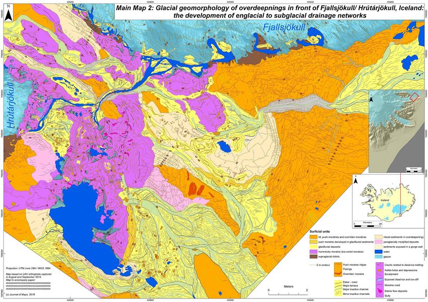
(Evans at al., 2016, Journal of Maps)Detailed geomorphological maps: Fjallsjökull
Detailed geomorphological maps: Nordenskiöldbreen
Thank you for your attention☺
If you have any questions or if you are interested in cooperation,
please contact us:
Aleksandra Tomczyk alto@amu.edu.pl
Marek Ewertowski marek.ewertowski@gmail.com
Greetings from Colombia!You can also read