Gated/gating community: the settlement complex in the West Bank
←
→
Page content transcription
If your browser does not render page correctly, please read the page content below
Gated/gating community: the settlement complex
in the West Bank
Ariel Handel
The claim that the settlements in the West Bank are gated communities might seem trivial. Those settlements are
an explicit example of a community featuring, on the one hand, social cohesion based on shared values, while, on
the other hand, self-isolation with the help of fences and a stress on the ‘security of the community’. The argument
of this paper, however, is different. The paper suggests that the settlement layout in the West Bank is not just an
aggregate of 124 ‘legal’ gated communities and a similar number of ‘illegal outposts’, but rather a single,
contiguous gated community gating, in turn, Palestinian ‘islands’ within it. The reading I will offer seeks to look at
the space in question through a careful reading of its use values. The emphasis is put on the question of mobilities
in order to show how the fortressed points turn into an exclusionary web by means of separated roads and
movement restrictions. By analysing the combined system of settlements, roads, military legislation, spatial design
and applied violence, the paper shows how the few hundred points consolidate into one coherent spatial system.
The paper wishes to contribute to the spatial analysis of the now 45-year-old Israeli occupation of the West Bank,
to the growing study of politics of mobility and to the discourse of gated communities by adding colonialism and
violence to the mostly neoliberal explanations of the phenomenon.

Key words       gated communities; Occupied Palestinian Territories; settlements; roads; mobilities

Harry S. Truman Institute for the Advancement of Peace, The Hebrew University, Mount Scopus, Jerusalem, 91905, Israel and Minerva Humanities
Center, Tel Aviv University, Tel Aviv 69978, Israel
Email: arielhan@yahoo.com

Revised manuscript received 5 March 2013

                                                                         the internal sense of community and the demarcation
Introduction
                                                                         from the outside have intensified. The creation of a
The claim that the settlements in the West Bank are                      spatial and conceptual dichotomy between ‘us’ and
gated communities might seem trivial. Whether looking                    ‘them’, between ‘here’ and ‘there’, has thus been
at the ‘security’ or at the ‘socio-cultural’ definitions of              completed.
gated communities as they appear in the geographic                           The argument of this paper, however, will be
and sociological literature, it is difficult to think of a               different. What the paper shows is that the settlement
more explicit example of a community featuring social                    layout in the West Bank is not just an aggregate of 124
cohesion based on shared values on the one hand, and                     ‘legal’ gated communities and a similar number of
self-isolation with the help of fences and a stress on the               ‘illegal outposts’,1 but rather a single, contiguous gated
‘security of the community’ on the other. From the very                  community gating, in turn, Palestinian ‘islands’ within
beginning of the settlement project, a clear separation                  it. This assertion might sound puzzling: the sum total
has been maintained between the Jewish settlers and                      of built-up areas in the settlements amounts to less
their Palestinian neighbours, a separation that has only                 than 2 per cent of the West Bank’s territory; the
deepened as years have gone by. Following various                        settlers’ number (including East Jerusalem) amount to
stabbings and shootings of settlers by Palestinians                      less than 15 per cent of the West Bank’s population;
within the premises of the settlements themselves, the                   and the total area occupied directly by the settlement
latter have increasingly shut themselves off from the                    complex (that is, the area falling within their municipal
Palestinians. From 1996 onward, Palestinians have been                   jurisdiction) amounts to circa 42 per cent of the West
prohibited from entering settlement premises for                         Bank’s territory (B’tselem 2002a). These figures seem
any purpose other than work, and workers have been                       to make it difficult to claim that the settlements
subjected to tight surveillance. Since the outbreak                      constitute a single, contiguous, gated and gating
of the Al-Aqsa Intifada in September 2000, secu-                         community.
rity procedures have been further tightened and the                          The paper proposes to look at the space in question
fences significantly reinforced. At the same time,                       through a careful reading of its use values. That is to

                  The information, practices and views in this article are those of the author(s) and do not necessarily reflect the opinion of
                                         the Royal Geographical Society (with IBG). ISSN 0020-2754 Citation: 2013 doi: 10.1111/tran.12045
                                                              © 2013 Royal Geographical Society (with the Institute of British Geographers)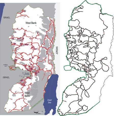
2                                                                                                                  Ariel Handel
say, in contrast to the dichotomous maps presenting the               aimed at helping to explain how – despite its clear
Israeli and Palestinian areas in different colours, I will            spatial and demographic inferiority – Israel and the
ask what usages of the space are available to each of                 Jewish settlers dominate the West Bank. The discussion
the two parties: Who is allowed to move, in what ways,                of gated communities in this paper also seeks to expand
where from and where to? To whom does the public                      the gated communities discourse by adding colonialism
space belong? For whom is the space contiguous and                    and explicit violence to the equation.
for whom is it segmented? Thus I will show how the                        Israel’s occupation of the West Bank and Gaza Strip
settlements have been constantly expanding their                      is usually thought of in terms of colonialism (Gregory
(physical or virtual)2 fences in the direction of the                 2005; Hass 2004; Reuveny 2003), apartheid (Bakan and
Palestinian space with the aim of creating a contiguous               Abu-Laban 2010; Dayan 2009; Zreik 2004), ‘creeping
Jewish space, whereas the Palestinian communities                     apartheid’ (Yiftachel 2009) or ethnocracy (Yiftachel
have become isolated islands at the heart of the                      2006; Yiftachel and Ghanem 2004).3 Ann Stoler (2006)
settlements’ contiguous ‘security envelope’. The out-                 reminds us that there are so many types of colonialism
come of this process, I will argue, is a contiguous, rapid,           that it has become difficult to define what colonialism
tightly knit Jewish space and a fragmented, slow,                     is. This paper will attempt to describe a specific type of
uncertain Palestinian space gated in by its Jewish                    colonialism, separation and population management.
counterpart.                                                          The macro-level of analysis is by no means abandoned,
   The study draws upon a large corpus of data                        but rather refined and fine-tuned through careful
gathered in the Occupied Territories by academic                      examination and analysis of the micro-level. In other
scholars, NGO reports and newspaper articles. How-                    words, the colonial frame might not in itself be
ever, this is not an empirical paper, but a conceptual                sufficient for a full analysis and understanding of the
study that tries to analyse the spatial significance of the           phenomenon. This is not to say that the Occupied
existing knowledge in order to describe the gated/gating              Territories case is sui generis – not at all – but detailed
community in the West Bank. It will concentrate on the                cases should be compared in order to extract the
deep logic of the spatial design and function during the              relevant categories, rather than to ask whether a case
occupation years in order to show how the situation of                falls into a ready-made category that always has its
rapid and fluid Jewish movement versus slow and                       excesses.
blocked Palestinian movement has developed. The                           Thus the prism of gated communities employed in
phenomenon described reached its peak during the                      this paper is not meant to serve as yet another ‘ism’
second Intifada (2000–2007), when hundreds of check-                  such as ‘gatism’ or the like as a new catch-all phrase
points blocked Palestinian movement and disrupted                     that has some inherent and comprehensive explanatory
everyday life (Bishara 2006; B’tselem 2007; Handel                    power. Rather, the notion of ‘gated community’ is
2009; Makdisi 2008;). Yet this qualification should be                helpful in clarifying how the categories of colonialism
qualified too. Although many of the checkpoints are                   or apartheid incarnate in the case of the Occupied
now open and movement is relatively free throughout                   Palestinian Territories. It helps to understand the ways
most of the West Bank, the logic of spatial design                    in which the spatial control of the Territories through
remains, and the potential for closure is always there.               means of openness and closure, control over the
The gates are in place and the whole array of blockages               entrances and exits, and management of the movement
can be redeployed in hours. Hence the description                     of people and goods (cf. Foucault 1977; Sack 1986) is
offered here is not historical but is rather a study of an            achieved and maintained.
existing case, always on the verge of deterioration.                      This paper focuses on the question of territorialisa-
   The paper comprises several sections. It begins with               tion by means of movement control, emphasising the
a theoretical introduction discussing various types of                role of the speed of movement and of infrastructures.
thoroughfares and their impact on the space they                      The comparison to gated communities suggests an
traverse. The second section will present the phenom-                 innovative mode of structural analysis and spatial
enon of gated communities in several cities around the                understanding of the Jewish colonisation process in
world against the theoretical backdrop provided in the                the West Bank. The paper wishes thereby to contribute
preceding section. The third section will demonstrate                 to three fields of knowledge: the study of Israel’s
how the space of the West Bank has become a space of                  occupation in the West Bank and Gaza Strip, the
clear differences between the two population groups,                  growing discourse on the politics of mobility (cf.
Israelis and Palestinians, due to the production of the               Cresswell 2010; Urry 2007) and the study of gated
gated/gating community.                                               communities. With respect to the latter, my contribu-
   The use of the concept of gated communities in the                 tion consists primarily in supplementing the usual
analysis of Israel’s spatial expansion in the Occupied                economic and cultural points of view with an emphasis
Territories is not intended to replace colonial or military           on the role of violence, colonialism and human
perspectives. Rather, it is a complementary perspective               movement in space and time. The study concentrates

ISSN 0020-2754 Citation: 2013 doi: 10.1111/tran.12045
© 2013 Royal Geographical Society (with the Institute of British Geographers)
Gated/gating community                                                                                                           3
on a mostly non-urban occupied area and highlights              (or who live next to a station) and one for those left
questions related to roads and networks.                        behind.
                                                                   So far we have been dealing with the longitudinal
                                                                dimension, that is, with the road as an acceleration
Roads: political economy in four
                                                                track (even if a selective one) between different points
dimensions
                                                                in space. But roads also have a breadth dimension: the
Roads are usually regarded as movement and acceler-             possibility of crossing the transportation route must
ation tracks connecting places to one another and               also be examined. Crossing a railroad is relatively easy.
compressing distances (as measured in terms of use              The case is different with a multilane highway, or when
value) between various points. But there are different          the rail/road is fenced or blocked. In such cases, the
kinds of thoroughfares and different ways in which they         connecting thoroughfares become separating ones,
influence the space in which they reside.                       parcelling out the space into subcells. The thorough-
   The political economy of roads should be studied in          fares connecting those with economic means (who are
four dimensions: (1) longitudinal acceleration of priv-         thereby capable of purchasing a ticket or holding a
ileged populations between privileged points; (2)               car), or those belonging to the ‘right’ nationality or
widthwise deceleration as a result of the spatial block         race, are the very same thoroughfares that block the
created by wide or fenced roads; (3) vertical separation        rest and restrict their movement. The more rapid and
between different movement plateaus prioritising one            technologically advanced the movement, the more it
population’s speed, usually at the expense of the               brings the privileged points closer to each other, the
other’s; and (4) time–space communities, which are              less it is accessible to a greater number of human
created by the roads’ networks, and are the focus of the        beings.
current paper.                                                     To explain the way in which thoroughfares can parcel
   In von Th€unen’s (1826) well-known The isolated state        out a space, consider the following historical example.
there is a hypothetical model of an isolated city situated      In his book on the history of barbed wire, Reviel Netz
at the heart of a uniform and fertile plain extending to        (2004) describes the way in which the latter has served
infinity. Around such a city, concentric belts of various       the occupation of space. When the wire was invented in
land uses would form, in a configuration reflecting the         the 1870s, it was designed for cordoning cattle herds
respective amount of labour required and transporta-            and restricting their movement. The first time barbed
tion costs. When a canal is dug across the plain, von           wire was used overtly for controlling human beings and
Th€unen claims, the belts would extend themselves               for deciding a war over space was in the Boer War
alongside the canal, due to the accelerated speed of            (1899–1902). In this war, Britain set out to defend its
movement, which leads in turn to diminishing trans-             interests in South Africa, above all the gold mines that
portation expenses (of workers from the city or of              were just being discovered during those years.
products to the market). The space thus becomes more            Although the first battles against the Dutch settlers
‘condensed’ and distances become shorter; in other              were quickly decided in favour of Britain, the Boers
words, an alteration occurs in the relation between the         subsequently started organising themselves in com-
absolute value (distance in metres) and the use value of        mando units comprising horse-mounted riflemen who
the space.                                                      attacked the British garrison force and blew up the
   The example of the canal, however, is idiosyncratic          railroads used as a major platform for transporting
and not similar to other rapid transportation routes.           merchandise and military forces.
The canal’s relative advantage is clear: it is accessible to       In their attempt to protect the railroads, the British
all those who live alongside it, and no more than a             turned to a method commonly used at the time to
simple boat is needed in order to reduce the distance           protect railways from wandering animals: barbed wire.
from the city. Such is also the case with pathways or           Thick barbed-wire fences were put up alongside the
with regular roads. Highways and railroads, by contrast,        railways that, as in any other place under British
are not so freely and immediately accessible, thereby           control, traversed many other places. The stretches of
leading to a significant spatial distortion. Slums tend to      barbed-wire fences were punctuated by the British with
develop alongside highways exiting the big city, yet            small guard posts about a kilometre apart. This method
without improving the mobility of their residents. Nor          proved successful beyond all expectations: the new
do trains stop just anywhere; they only stop at                 technology created spatial enclaves that made it pos-
predetermined stations, and whoever lives in-between            sible to control extensive territory with a relatively
stations remains transparent to the passing trains. Put         small military force. A handful of soldiers could from
simply, the laying of a railroad or the construction of an      now on keep at bay and push back a fairly large
inaccessible highway creates privileged points at the           commando unit.
expense of the overall space, thereby producing two                Netz (2004) demonstrates how the railroad network
distinct spaces: one for those who can afford a ticket          became an instrument of spatial control using lines

                                                                           ISSN 0020-2754 Citation: 2013 doi: 10.1111/tran.12045
                                                      © 2013 Royal Geographical Society (with the Institute of British Geographers)
4 Ariel Handel
connecting various points (i.e. train stations). Once the make sense of the factory or the mine without the
railway network had been fortified with barbed-wire railroad that reaches all the way to the port; and so on.
fences, a ‘topological inversion’ took place: the lines This state of affairs is even more evident when use of
connecting the stations became separation lines discon- the rail/road is available exclusively to one population
necting one plain from another. The South-African group. In early 20th-century South Africa, the railroads
savannah was split up into relatively small parcels of did not merely connect British places, but were part of
land surrounded on all sides by barbed wire. Thus, once the very spatial apparatus and rationality that made
the isolated points had been connected with defensible those places possible. The railroads themselves were, in
lines, control over these points amounted to control fact, British places. A similar dynamic takes place, as I
over the entire space. will show below, in several gated communities around
In other words, routes traversing a plain are not the world, and may also be discerned very clearly in the
neutral lines, as they might appear in the conventional spatial layout of the Jewish settlements in the West
way of mapping according to absolute values. Rather, Bank.
thoroughfares transform and distort the space. They
bring certain points closer to each other while setting
others further apart. In the case just described, two Gated communities: points, lines and
distinct spaces were created: a cohesive, connected networks
British supra-space, its points close to each other, and a
The phenomenon of gated communities is on the rise
disjointed, parcelled-out South-African infra-space, its
all over the globe and can be found in the USA,
points distant from each other. To be sure, these spaces
Canada, the UK, East Asia, Africa, the Middle East,
do sit one on top of the other – and in the conventional
and more (see overview and references in Grant and
mapping based on absolute values it is indeed difficult
Mittelsteadt 2004; Rosen and Razin 2008). In Israel the
to tease them apart – but when use values are brought
topic is studied mainly in Gillad Rosen’s works (Grant
into play, two strictly separate spaces are revealed.
and Rosen 2009; Rosen and Grant 2011; Rosen and
To this, we should add the vertical separation.
Razin 2008 2009), in Haim Yacobi (2012), and in a
According to Michael Sorkin, there is a constant desire
quite recent edited volume of essays (Lehavi 2010).
to
While some put the emphasis on the physical gates or
increase speed (and save time) by prioritizing the faster on the limitation of access and closure of roads (cf.
means of movement … Typically, this means slower vehicles Blakely and Snyder 1997; Caldeira 2000; Grant and
yield to faster ones and pedestrians to all, walkers deferring Mittelsteadt 2004; Landman 2006; Marcuse 1997a
to cars, cars to trains, trains to planes and so on. Modern city 1997b), others emphasise the homogeneity of residents
planning is structured around an armature of such conflict
and the shared values or goods of the community
avoidance. (Quoted in Diken and Lausten 2005, 66–7)
(Grant and Rosen 2009; Rosen and Grant 2011; Rosen
This ‘conflict avoidance’, which means making the and Razin 2008).
fast ones faster while still allowing the slower to move Gated communities differ on several factors of
(in cases that are not as extreme as that described enclosure, security features, amenities, type of resi-
above by Netz), leads to a growing tendency towards dents, tenure, location, size and policy context (Grant
separation of the movement into different layers, where and Mittlesteadt 2004). They tend to turn their backs
interchanges substitute junctions. This is actually the on the city and aspire to create an autarkic community
passage from the two-dimensional description of the that has no need for the outside world.5 In Jakarta, for
longitudinal acceleration and the widthwise decelera- example, there are gated communities boasting hospi-
tion towards the three-dimensional roads’ system.4 tals, shopping centres, sports centres and a university;
It is the vertical separation that makes smooth travel and in Beijing there are communities operating their
across space possible, and the ‘conflict avoidance’ is own electricity and water networks, independently of
what creates separate time–space communities, to the municipal infrastructure. Yet not all communities
which the rest of the paper is devoted. It may be are capable of achieving this goal of self-segregation to
argued that in the supra-space system, the separation such an extent. The hindering constraint is usually
between the points and the lines is artificial and economic, having to do mainly with the population size
superfluous. Fiona Wilson suggests that ‘instead of and the ‘entry threshold’ beyond which it would be
envisioning roads as neutral lines going from point A to economically profitable to introduce a given product
point B, they should be visualized as stretched-out into a certain area: ‘the more self-contained a commu-
places’ (2004, 529). This claim is very plausible. It is nity is, the less frequently inhabitants need to venture
impossible to make sense of the suburb without the outside’ (Grant and Mittelsteadt 2004, 923).
road through which it is accessed, and which constitutes In large and economically powerful gated commu-
a condition for its very possibility; it is impossible to nities, many products cross the entry threshold, going
ISSN 0020-2754 Citation: 2013 doi: 10.1111/tran.12045
© 2013 Royal Geographical Society (with the Institute of British Geographers)Gated/gating community 5
as far as the establishment of hospitals and universities. In this way, gated communities completely alter the
And what happens when the communities are small physical space. They split the city into two layers, one
and scattered? In such cases only the residential area is connected and the other fragmented; one in movement
closed and secured, whereas every outing for shopping and the other frozen. The highways that traverse the
or for work involves exiting the compound to the city to connect the gated communities to each other are
‘hostile areas’ of the city. There are various ways of extremely hazardous and exact a heavy toll of victims
addressing the problem of transition between secure (Davis 2006, 132). Thus, even though an official
compounds. One example comes from the city of Sao prohibition against crossing them does not necessarily
Paulo, Brazil, where ‘helicopter taxis are fast becoming exist, these roads have created highly efficient demar-
one of the most popular means of getting around cation lines (resembling Netz’s ‘topological inversion’).
Brazil’s most populous city’ (Diken and Lausten 2005, The gated communities are close to each other,
94). The well-off residents of Sao Paulo move among constituting in effect a single, contiguous complex,
the various gated communities, or between them and whereas the rest of the city undergoes fragmentation.
secure work and shopping centres, in complete detach- With the help of rapid roads that are dangerous to
ment from the city, high above it. Indeed, it is difficult cross, a relatively uniform, contiguous and organic
to think of a mode of transit that is more detached from space has become fragmented just by dint of the
the city below. Yet this mode of transit, precisely due to possibilities of movement within it. Put differently,
the extremity of its detachment, has no impact on the there is no single, clear, contiguous borderline sepa-
traffic in the city itself. In the terminology articulated rating ‘here’ from ‘there’, but a series of various kinds
earlier about thoroughfares and their impact, this mode of demarcation lines that fundamentally alter the space.
of transit greatly diminishes the distance between This state of affairs is often found in the inner cities
points in the longitudinal dimension, but has no as well, in cases where residents obtain municipal
simultaneous impact on other dimensions. approval to demarcate, gate and restrict entry to
A different example is that of Managua, Nicaragua. previously open areas (cf. Berner 1997; Jurgens and
In Managua, as described by Dennis Rodgers, there is a Gnad 2002; Landman 2003 2006). I underscore this
growth – for various geographical reasons that are not aspect of gated communities in inner cities in order to
pertinent to our discussion – of relatively small gated point to the way in which an existing space is altered.
communities dispersed over numerous places across That is, unlike communities located at the outskirts of
the city. These communities are not large enough to be town – and therefore pre-planned as separate – the
autarkic, and their economic status is not sufficiently communities within the cities close off a part of the city
established to enable the renting of helicopters. The that used to be contiguous, and impose a different
solution found with the massive support of the munic- regime of movement in a space that previously had no
ipality and the government was the construction of a restrictions.
highway network linking the various communities, such This model makes it possible to identify the trans-
that in effect a single, city-wide system was created. formation of space from egalitarian and public to
According to Rodgers, inegalitarian, private and exclusive through diverse
methods of acceleration and deceleration. The model
it is the interconnection of these privately protected spaces shows how the modes of transit and the fences enhance
that constitutes them as a viable ‘system’, and it can be the contiguity and stability of the space of one
contended that the most critical element that has permitted
(minority) group at the expense of the other (majority)
the emergence of this ‘fortified network’ has been the
group; or in other words, how self-segregation, which
development of a strategic set of well-maintained, well-lit,
and fast-moving roads. (2004, 120–1) produces a single, autarkic and stable place for the
minority, at the same time fragments the space of the
In other words – and especially if we keep in mind majority to numerous small places that are not self-
Wilson’s suggestion to see roads as ‘stretched-out sustainable.
places’ (Wilson 2004, 529) – the spatial dispersal of
Managua’s gated communities may be viewed, not just
The settlement complex in the West Bank
as a ‘system of connected communities’, but really as
as a gated/gating community
one single space–time community. The thoroughfares,
just like the gated communities themselves, belong to In their account of the evolution and development of
one population stratum only. These are multilane, enclosed residential neighbourhoods in Israel, Gillad
gated highways, in which intersections are replaced by Rosen and Eran Razin distinguish between three types
interchanges (making an effective vertical separation). of enclaves: landscapes of heritage (ultra-orthodox
However, the highways are not linked to the slower Jewish cities, inner division of a Bedouin city), fortress
roads (leading to and from the poorer or pre-Sandinista landscapes (frontier settlements in Israel and in the
areas). Occupied Territories) and fortified and privatised
ISSN 0020-2754 Citation: 2013 doi: 10.1111/tran.12045
© 2013 Royal Geographical Society (with the Institute of British Geographers)6 Ariel Handel neighbourhoods (new urban gated communities). bourhoods’ of existing settlements, although located Rosen and Razin explain that the fortification of rural several kilometres away) as well as ‘illegal’ outposts in settlements in frontier areas was a common feature and the West Bank.7 Israeli geographer Elisha Efrat (2006) symbol throughout most of the 20th century (see also claims that the settlements have failed because they Carmon 1994; Falah 1996; Tzfadia and Yacobi 2011). have been unsuccessful in creating a critical demo- The West Bank settlements are therefore direct graphic mass, and that their geographical dispersion descendants of this type of gating (see Rotbard 2002), has weakened them and proved counter-productive. while displaying even more intensely the features of His approach, deriving from the classical planning- fortification and fencing, as will be discussed below. geographical position, misses the complexity of the Fortified settlements, gates and enclaves are hardly a spatial expansion process described here. To be sure, new phenomenon, of course (Marcuse 1997a; Wu the number of settlers today amounts only to 15 per 2005). They differ widely in the reasons for enclosure cent of the entire population of the West Bank (fear, ethnicity, race, class, shared values, etc.); the (including East Jerusalem), and the built-up area of specific features of the closure (What type of gates? the settlements encompasses less than 2 per cent of the Are they open or closed? During daytime or night- West Bank’s territory (B’tselem 2002a). Judging by time? Are there walls? Are there armed guards? What traditional indices, the settlers are indeed at a clear happens to an intruder? etc.); the relations between the nominal inferiority. But these indices overlook the most gated entity and its neighbouring area (Work relations, important factors in the organisation of space and its shopping and shared facilities? Relations marked by usage: the settlements’ location, their form and trajec- fear and mutual suspicion?); and the policy context (Do tory of development, the roads connecting them to the state or municipal authorities encourage or dis- each other, and the military practices employed to courage the gating? Do they supply resources and state protect the settlements and the roads. It is precisely power in favour of the gated?). these variables that adumbrate the true scale of Israel’s My examination of the gating phenomenon in the seizure of control over the West Bank. These are the West Bank deals with those categories: the reasons for most significant factors for making sense of the points’ enclosure, the closure’s characteristics, the relations dispersion and of their connection by secured lines – with the neighbouring area and the policy context. roads functioning simultaneously as acceleration tracks Regarding the reasons for enclosure, the settlements in and as separation lines. the West Bank were part of a network since their very The settlements have been dispersed over the area inception, both in their positive features of shared by calculated design. The settlers have well understood ethnicity and values and in their exclusionary character that ‘our hold over a stretch of land does not depend on with respect to the Palestinian population. Also, Israel’s the size of the population inhabiting it, but also on the purpose was to seize as much land as possible, size of the area on which this population leaves its therefore planning the settlements’ form and dispersion imprint’ (Gush Emunim 1980, 15). The map of the as part of a wide network (Eldar and Zertal 2007; settlements, based on the settlers’ plans and backed by Weizman 2007). As for the closure’s characteristics, the the state’s apparatuses and its military power, shows settlements’ closure was achieved for many years how the latter have fanned out over the entire space – without walls and gates. Until the first Intifada (1987) often deliberately at the heart of Palestinian population those were hardly needed, and they definitely did not concentrations (Figure 1). Many of the settlements justify their high costs. But even later, as the settle- have been established very close to Palestinian habita- ments were becoming increasingly dangerous places, tions, in a way that prevents the latter’s development. most of the settlements refused gating as the settlers In some of the cases, a settlement would be established knew that fences and gates would limit their expansion precisely in an area that constitutes the natural and make them feel closed and ghettoised (Eldar and destination (for topographical reasons) for the future Zertal 2007; Handel 2009). In fact, the Jewish settle- expansion of the Palestinian habitation (B’tselem ments started gating themselves only after they had 2002a). turned into a single, fortified net cast wide enough as to Most of the Israeli settlements in the West Bank are constitute not a gated but a gating community. Finally, very small. Forty per cent of them are inhabited by the settlements’ relations with the surrounding area fewer than 500 people; 20 per cent are inhabited by had always been exclusionary, but they gradually came 500–1000 residents; another 18 per cent are the home to encompass more and more domains: from separate of 1000–2000 people; 14 per cent have a population of settlements to separate road network. The ethnic 2000–5000; and only 8 per cent have a population feature effected a clear-cut separation between the higher than 5000 people. As for the outposts, only 7 per populations, their villages and later their cars.6 cent of them have more than 100 inhabitants, and the Since its occupation in 1967, Israel constructed over biggest outpost inhabits 750 residents.8 This population 250 ‘legal’ and ‘half-legal’ settlements (built as ‘neigh- distribution means that most of the settlements are not ISSN 0020-2754 Citation: 2013 doi: 10.1111/tran.12045 © 2013 Royal Geographical Society (with the Institute of British Geographers)
Gated/gating community 7
into cohesive blocks that add up to real territorial
contiguity. In any case, the emphasis in the planning is
not necessarily on the physical distance between the
points, but mainly on the symbolic distance and on the
sense of security of those using the space.
Every settlement established in the Occupied Terri-
tories has carried a road in its train, even when it meant
breaking new paths through difficult, rocky and
extremely steep terrain. Ten kilometres of roads were
required in order to connect the settlements of Kadim
and Ganim (300 inhabitants) to the Jenin bypass road;
a 14-kilometre road has been paved for 300 people
living in the settlement of Shim’a; and over 30
kilometres of road have been paved between Tkoa
and the Dead Sea in order to connect roughly 550
settlers living in Ma’ale Amos and Mitzpe Shalem
(Efrat 2006, 84). In the same way, every outpost also
gets a paved road connecting it to the main road.
Over the years, hundreds of kilometres of bypass
roads have been constructed, especially since the Israeli
military’s withdrawal from the Palestinian cities in the
mid-1990s and the partition of the West Bank into
Areas A, B and C. These roads bypassed the Palestinian
cities and villages and connected the settlements to each
other and to Israel west of the Green Line (the armistice
line that marked the border between Israel and its
neighbouring countries in 1949); but until the mid 1990s
they also served Palestinians driving within the West
Bank and commuters working in Israel. While the roads
did serve as an effective barrier against the development
of Palestinian villages, and significant restrictions have
been imposed on construction in their proximity, the use
of the roads themselves was still shared. Starting in the
second half of the 1990s, and even more so following the
outbreak of the second Intifada in September 2000, the
policy was changed: Palestinian movement became
forbidden on many roads, and sometimes even crossing
or approaching the roads was prohibited.
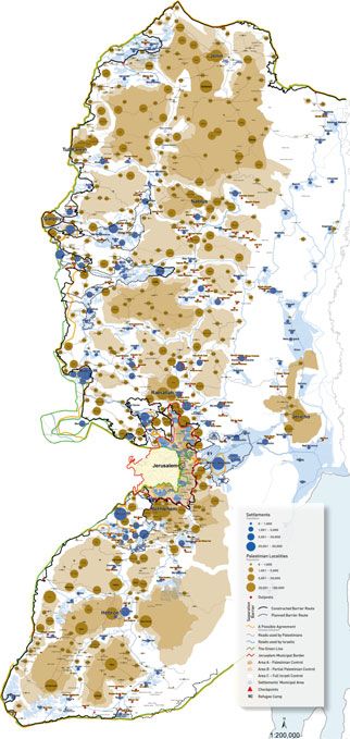
Figure 1 Map of the settlements in the West Bank, It is important in this connection to grasp the deep
November 2013 significance of the threat, real and perceived, to Jewish
Source: Peace Now movement between the settlements in the West Bank
and Gaza Strip, especially during the Intifadas. This
self-sufficient, autarkic entities and that safe movement threat, more than any direct attack on one specific
between them is crucial. settlement or another, touched the Achilles’ heel of the
Establishing a chain of small settlements situated at logic of the settlement complex. The struggle over
strategic distances from each other – sufficiently close movement, therefore, was of strategic significance, as
to enable connection on the one hand, but sufficiently both sides very well understood. The following words –
far apart to enable efficient dispersion on the other – is written by Pinhas Wallerstein, Head of the Binyamin
an efficient way of seizing large areas in a short time Regional Council (near Ramallah) – underscore the
and with relatively few resources. This advantage comes importance of movement between the points that make
at the price of lack of available services (schools, clinics, up the settlement complex:
shopping centres and so on) and a diminished sense of
security. Yet it is precisely for this reason that roads, We will lose control of any area we won’t be driving in. In Arab
throughways and lines of communication become population centers where we won’t be driving continuously,
doubly important, and their expansion and fortification our ability to move freely will diminish … Our very presence
are meant ultimately to turn all these settlement points or mobility makes contiguous Arab control more difficult …
ISSN 0020-2754 Citation: 2013 doi: 10.1111/tran.12045
© 2013 Royal Geographical Society (with the Institute of British Geographers)8 Ariel Handel
Jewish presence in the settlements, and the connections and reports show how a route that once took an hour’s
between them, will in effect confine the area of influence of drive turned to be a whole day’s journey, and even
the Arab block … This block, if only for the sake of future more (B’tselem 2001; 2007; Kelly 2006; Makdisi 2008).
generations, must be cut into slices … Especially with roads More than that, it was a dangerous journey due to an
that will actually be traveled on! … It is extremely important
easy finger on the trigger on the part of both soldiers
to emphasize the importance of every single settlement …
and settlers (cf. B’tselem 2002b). That is why Palestin-
Its access roads and other infrastructure … Clearly, under
uncertain security conditions the natural tendency is to ians reduced their daily movement to the necessary
move out of the center [of the Arab block] and transfer all minimum. One example among very many is that of
movement to areas lying outside the Gav Hahar area Samar Sada from the village of Jit (a few kilometres
[Hebrew name for a major West Bank region densely outside Nablus), who recounted:
populated by Palestinians – AH] … [but this] will weaken
We’re imprisoned here. My children haven’t left the village
the connections and will enable a strengthening of the Arab
for four years. I haven’t gone to Nablus for four months.
block. (Wallerstein 1994, 28–9; emphases added)
Why should I go there? A soldier will tell me ‘Bring a
The solution to the threat was the separation of permit.’ I have a smart card for Barkan [Israeli industrial
zone; AH], but if there’s a soldier who has it in for Arabs, I
movement, and the priority was given to the Jewish
don’t know for what reason, he’ll tell me ‘Stop at the side.’
settlers. A report by the NGO B’tselem (2004) lists
So why should I go? I prefer to be at home, not to go out and
three types of West Bank roads on which Palestinian not to encounter such things. (Levy 2007)
movement is restricted: completely prohibited roads
(17 roads totalling 120 kilometres), partially prohibited With this mechanism, the topological inversion is
roads (10 roads totalling 245 kilometres) and restricted completed. The lines connecting the Jewish points
use roads (14 roads totalling 365 kilometres). The total become dangerous for Palestinian passage – either by
length of roads in the West Bank is roughly 2000 car or by foot – and in this way isolated islands are
kilometres, so that the various restrictions pertain to cordoned off (see Figure 2). This state of affairs was
over a third of them. This list compiled by B’tselem perpetuated politically and graphically with the parti-
refers only to relatively main roads, without referring to tion of the West Bank into areas A, B and C. Area C,
internal roads leading to settlements only. These little under full Israeli control, encompasses 60 per cent of
roads and their impact should not be underestimated. the West Bank’s territory. Scattered within it are no less
The roads function as a barrier because its crossing is than 190 separate islands of Areas A (full Palestinian
forbidden for Palestinians, and even approaching it is control) and B (Israeli security control and Palestinian
dangerous – be it for fear of harassment by soldiers or civilian control). The Jewish settlements and roads are
Border Patrol policemen, or for fear of the settlers who those that dictated this map, based on a clear assump-
might be violent and unpredictable. tion that ‘whatever is not already Palestinian will be
Hundreds of manned checkpoints and physical Israeli’. The boundaries of the areas given to Palestin-
barriers (iron gates, ditches, earth mounds and cement ian control often directly border on the built-up area,
blocks) blocked and tunnelled Palestinian movement and always at a large distance (security and future
during those years. The checkpoints along the Green development spaces) from the Jewish settlements and
Line were meant to prevent suicide bomb attacks in roads.
Israeli cities, but they made up no more than 10 per It should be made clear that the settlements had not
cent of the checkpoints.9 The other 90 per cent were been built with a premeditated intention of restricting
dispersed along the West Bank’s main arteries, blocking Palestinian movement, but mainly in order to restrict
Palestinian access to roads used by Jewish settlers. The Palestinian construction and to prevent the establish-
idea was to prevent shootings and stone throwing on ment of an independent Palestinian entity (just as the
settlers’ cars, but the strict priority to the settlers’ railroads in South Africa had not been laid down with
movement came deliberately at the expense of that of the intention of parcelling out the space and using them
the Palestinians. The blockages regime froze nearly all as an instrument for winning the Boer War). In both
Palestinian everyday life. It generated a high level of cases, however, the original intention makes no differ-
uncertainty, resulting in an inability to plan ahead and ence. Once the need for splitting up the space had
to fulfil simple daily activities such as work, study, arisen, the settlements and the roads served as an
maintenance of familial and social relations, and so on. excellent basis for barriers and splittings. The relatively
In 2004, for example, only 0.14 per cent of the new roadblocks and gatings are the realisation of the
Palestinians held a valid permit to cross internal potential of closure and bounding that had been
checkpoints in the West Bank (B’tselem 2004). embodied in the spatial organisation from its very
Eighty-five per cent of the West Bank Palestinians did inception. All that was needed in order to realise this
not leave their village in the first three years of the potential was to redefine the rules of movement and to
second Intifada (Gordon 2008, 209). Several studies reinforce them using dirt embankments and ditches.
ISSN 0020-2754 Citation: 2013 doi: 10.1111/tran.12045
© 2013 Royal Geographical Society (with the Institute of British Geographers)Gated/gating community 9
Figure 2 Left: Map of Israeli-only roads, 2007. Right: Map of Palestinian ‘land cells’ as created by the closures regime
Sources: Left: OCHA and right: Handel (2009)
This kind of technology for controlling space is quite less equally to everyone. Once the security and stability
cheap. It is much cheaper and simpler to erect dirt of one side is given preference at the expense of the
embankments at points of intersection between roads other, an acceleration process begins for one alongside
than to construct hundreds and thousands of kilome- a deceleration process for the other; expansion versus
tres of walls and fences. When we add the defence– blockage. Israeli stability is the cause of Palestinian
offence practices, which have the effect of thickening instability; Israeli acceleration generates Palestinian
the points and the lines by pushing Palestinian move- deceleration; the coming closer of Israeli points to each
ment further back, the emerging picture is that of an other has the effect of pulling apart the Palestinian
increasing isolation and constriction of Palestinian life points from one another; certainty for Israelis spells
to the premises of the now isolated villages (see Handel uncertainty for Palestinians.
2009). As in the case of Managua, the settlements – thanks
The settlements are not just discrete gated commu- to the rapid, gated and secured roads where the travel
nities connected by roads, but form a single, cohesive, of Palestinians is prohibited – form a single gated
stable system. The transition from Israel within the community connected safely to the Israeli mainland.
Green Line to the gated road leading directly to the This gated community gates within it all the other
gated settlement is smooth and rapid. Many of the communities left ‘inside’ (trapped between the roads)
roads travelled by the Jewish settlers are reserved but also ‘outside’ (excluded from rights, from attention
exclusively for them, and are thereby expropriated from and concern). This is a kind of ‘gating from within’,
the space surrounding them. The road is an integral which isolates the privileged minority while cordoning
part of the settlement complex, hence the two are off and pushing away all the rest (see Figure 3).
analytically inseparable. This complex not only leads to The role of movement has already been elaborated in
the strengthening and tightening of the network of Atkinson and Flint’s (2004) analysis of gated communities
Jewish communities, but at the same time also weakens in the UK. They claim that there are actually three
and fragments the Palestinian communities. As long as spatialities of segregated social actions: territories (i.e.
there is nothing more than a cluster of points sharing the fortified residential zones); objectives (i.e. nonres-
the same infrastructure, the space is available more or idential locations to which people travel on a daily basis
ISSN 0020-2754 Citation: 2013 doi: 10.1111/tran.12045
© 2013 Royal Geographical Society (with the Institute of British Geographers)10 Ariel Handel
Figure 3 The gated/gating web. Left: Situation before the fortressing of the web – Palestinian villages and Jewish
settlements share the same road network. Right: Paving bypass roads and fortressing of the Jewish nodes and corridors
creates a gated/gating web cutting off Palestinian villages
– work, leisure, etc. – which usually are also closed and walls. And as these corridors are the necessary condi-
have limited access); and corridors (which they define tion of possibility of the whole complex, huge efforts
as ‘modes of travel which suggest an attempt to shield are invested towards their maintenance.
or to immunise against casual or dangerous encounters’ Ronen Shamir (2005) makes an important theoret-
(888), such as cars, first-class train or air travel and ical distinction based on the difference between the
taxis). A similar argument is made by Rosen and Razin prohibition of exit and the prohibition of entry: the
(2008), who talk about the significance of segregated former is that which pushes away or apart, locking
means of movement as part of the gated communities people behind bars or confining them to ghettos, to
in Israel – from the uni-gendered buses of the ultra- camps and so on; the latter is that which underlies
orthodox communities to the segregated roads in the ‘admission committees’ to community settlements or
West Bank and toll roads that enable fast movement of the selection of those seeking to enter a monitored and
people of means. secure shopping mall. It might be worthwhile to try to
Still, the research presented here differs from classify the modes of policing of movement according
Atkinson and Flint’s as well as from Rosen and Razin’s to the space left between the borders of closure and the
arguments on two major points. First, in the case of the borders of entry: between the walls of a prison and the
West Bank, the roads are not only separated ‘corridors’ gates of a shopping mall; between the fences surround-
but are a necessary and critical part of the settlement ing the refugee camps and the borders of Western
complex, without which it will collapse. They have been countries. From this analytical perspective, the West
integral to the planning of the Jewish West Bank at Bank settlement complex emerges as a gated/gating
least from the 1980s (Handel 2009); and the regular, community: as opposed to other places around the
uninterrupted use of the roads has ever since then been world, in the Territories it is impossible to separate the
perceived as critical (Wallerstein 1994). The West Bank prohibition of entry from the prohibition of exit. In the
roads themselves have been unsafe since the outbreak West Bank, self-gating and other-gating are one and
of the first Intifada in 1987, so car-based separation has the same.
never been enough, leading to the conclusion that the We may distinguish here between two different
roads themselves should be separated too (and even stages in the evolution of the complex, which, despite
access to the road and its crossing should be limited). being staggered chronologically, are by no means
Secondly, in the West Bank, the self-gating of one separable by a clear-cut demarcation line. The two
population does not mean only ‘lack of diversity’ in the stages are ideological gating and security gating, the
public space (Atkinson and Flint 2004), but actually latter having been added historically as a second layer
blockage of movement and destruction of the public on top of the former. To be sure, the security aspect of
space for the other population. The separation is not the spatial separation had existed in the settlements
on a voluntary and individual basis, but rather a state- from their inception, but it had been less conspicuous
organised, military- and violence-based separation. The during the first years of the settlement project. The
uni-national corridors are at the same time uni-national significant shift occurred with the outbreak of the first
ISSN 0020-2754 Citation: 2013 doi: 10.1111/tran.12045
© 2013 Royal Geographical Society (with the Institute of British Geographers)Gated/gating community 11
Intifada, and intensified with the Oslo Accords and described earlier. The security layer was added onto
especially since the beginning of the second Intifada. the ideological bedrock and intensified the physical
The first type of gating – which in most cases has not separation.
been accompanied by physical gating – manifested itself Talking about a system and about one gated/gating
in the construction of settlements in detachment from community is not meant to conceal the differences
their Palestinian environment. This desire for self- and the heterogeneity of the settlements. Some are
segregation is actually the same motive for enclosing religious, others are secular; some are rural, others
that guided the fortress landscapes described by Rosen urban; some are considered ‘ideological’ (the hard core
and Razin (2008), namely settlements that were built of the Jewish settlements, usually located in the heart
from the beginning as separate entities. Segal and of Palestinian areas) while others are for ‘housing
Weizman (2002) indicate this self-segregation as it improvers’, who take advantage of the relatively low
reveals itself in the architectural style of the settle- prices of houses and the generous governmental
ments’ red-roofed houses; in the differences of latitude support given to people who move to the West Bank.
between the settlements and the Palestinian villages, These myriad kinds of settlements do not create one
the former resting on hilltops and mountaintops and community except in the sense of a relatively weak set
the latter residing on hillsides, beneath the settlements; of shared values and amenities. But they do create one
and so on. But beyond the architectural separatism gated community in its functional aspect. According to
there is also a complete self-segregation with respect to Grant and Mittelsteadt, ‘the key element of gating is
the social and economic systems, the sharing of which – the effort to control access to the settlement. Gated
in contrast to the electricity and road infrastructures – developments have an inside and an outside’ (2004,
has never been intended. It has always been completely 914). While the question ‘whether gated enclaves are
clear that with respect to education, culture, shopping true “communities” is open to debate’ (2004, 914), the
and leisure centres, and so on, there would be no gatedness and the limits on access and free movement
mixing between the existing (Palestinian) system and is what defines the gated community and what sepa-
the incursive (Jewish) system. In general, Israel’s rates the inside from the outside. Therefore, even
incursion into the Territories may be characterised – though a settler from Ma’ale Adumim (a large urban
in correlation with old colonial practices – as expan- settlement near Jerusalem) may perhaps never visit the
sion-cum-separation. Ethnically based separation had settlement of Tapu’ach (small extremist settlement at
always been crystal-clear and beyond any doubt, even the outskirts of Nablus), the two are nevertheless
before actual fences were erected between the habita- connected by fast roads and a security envelope that
tions, and even when the use of roads had still been keep them cut off from their immediate environment,
open to everyone. in a way that creates an ethnically based inside and
In this relatively initial phase of the settlements outside.
(which started to decay in the first Intifada, and ended
for good with the second Intifada), there was not yet a
settlement system of the kind I have characterised Conclusion
earlier. The ideological communities were relatively Zygmunt Bauman claims that
autonomous, or were at least clustered into small- or
medium-scale settlement blocks. The space was not mobility climbs to the rank of the uppermost among the
divided into two detached and sharply differentiated coveted values – and the freedom to move, perpetually a
scarce and unequally distributed commodity, fast becomes
spaces, Israeli and Palestinian. The settlement complex,
the main stratifying factor of our times. (1998, 2)
the Jewish supra-space in the Territories, had not yet
attained its full realisation, and the Palestinian space This paper seeks to describe the differential move-
was still usable and relatively open to movement. ment of populations – not on a global scale, as Bauman
Stabbings of settlers by Palestinians working in the does, but rather in its micro-geographical incarnations
settlements and terror attacks in settlements and in gated communities and local roads.
houses instigated the addition of the ‘security commu- Most of the literature on gated communities deals
nities’ aspect. The security gating was subsequently with closed compounds and their relations with their
expanded to the road network as well, following a immediate surroundings or with the municipal level.
dramatic rise in shooting incidents on the roads from Several works refer also to roads and other differen-
the mid-1990s onward. It is only in the mid-1990s that tiated means of movement (Atkinson and Flint 2004;
we see the beginning of a significant gating process of Landman 2006; Rodgers 2004; Rosen and Razin 2008).
the settlements, and later of the roads as well. The This paper adds to those studies by emphasising the
gating, the segregation of roads and the movement zero-sum game in which the problem of the separation
restrictions imposed on the Palestinians are the factors of movement goes beyond the mere absence of the
that converged to create the settlement complex strong population from the public space, or the mere
ISSN 0020-2754 Citation: 2013 doi: 10.1111/tran.12045
© 2013 Royal Geographical Society (with the Institute of British Geographers)You can also read