General aviation guide for Norway 2020 - Luftfartstilsynet
←
→
Page content transcription
If your browser does not render page correctly, please read the page content below
General aviation guide for Norway 2020

This guide is made to help you to prepare and conduct your ight. You will also
 nd some good tips and trips to cope with special hazards that are common in the
Norwegian environment.

Cover photo: Roger Holm

    Introduction

    Entering or leaving Norway

    Flight planning

    Airspace, communication and reporting

    Tips for safe operations

    Emergencies and survival

    Contact information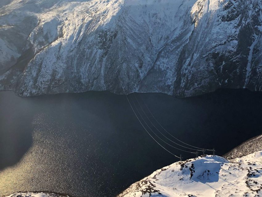
VFR guides for other countries
Lesson 1 of 8

Introduction

      Pilots are invited to consult this guidance material on the understanding that it does not
      represent a substitute for the more comprehensive information contained in the AIP or
      regulations. In the event of con icting information in this guide, information in the AIP or
      relevant regulation should be regarded as the authoritative source.

      Please note that the Norway AIP can be viewed free of charge at: www.ippc.no The vast
      majority of the Norwegian landmasses consist of mountainous terrain with countless valleys
      and deep fjords. You will enjoy spectacular scenery and great fun while     ying in these areas,
      but you should also bear in mind that the environment may suddenly “bite” you during
      unfavorable   ight conditions. During low level   ight, obstacles like power spans and masts,
      some of them not or only partly marked, will also pose a signi cant threat to you and your
      aircraft.

      We hope this course will increase your awareness of unfavorable       ight conditions. Relevant
      rules and regulations applicable to   ights within Norway are covered and so is other
      information necessary for safe planning and conduct of     ight.

      Set your own limitations and prepare for the expected so you do
      not have to recover from the unexpected!
C O NT I NU E
Lesson 2 of 8

Entering or leaving Norway

                                 First landing in Norway shall be done at an airport with
                                                    international status.

      Norway is not a part of EU, but included in the Schengen agreement. Aircraft entering Norway
      has to    le a     ight plan at least 60 minutes before departure. As main rule       rst landing in
      Norway shall be done at an airport with international status. If your         ight meets certain
      conditions you may           y directly to other destinations.

      Privately operated aircraft with maximum take-o             mass not exceeding 5700 kg and a
      maximum of ten passengers may also use other air elds, in that case, a complete ICAO               ight
      plan shall be sent to the Directorate of Customs and Excise at the latest four hours prior to
      entering or leaving Norwegian territory. This requirement can be meet by forwarding a copy
      of your ICAO       ight plan by e-mail to desken@toll.no.

      Destinations within Norway without international status may be used if your               ight meets
      the following requirements:

                       Aircraft with a maximum permitted takeo         weight not exceeding 5700 kg and
                       approved for a maximum of ten passengers.

                       Private    ight or a taxi   ight.
You departe within the Schengen area.
You do not carry anything on board that must be decleard for Customs.
A copy of the ight plan must be presented to the Directorate of Customs
(desken@toll.no) at least four hours prior to arrival.
TOLL.NO
Relief in the duty to notify Customs about small
aircraft etc. in traf c between Norway and other
Schengen countries - Norwegian Customs
Regulations concerning relief in the duty to notify Customs about small
aircraft etc. in tra c between Norway and other Schengen countries.
(Regulations to the Act on Customs Duties and Movement of Goods (Customs
Regulations) - Section 3-2-2, 3-2 ..
READ MORE TOLL.NO
If stated arrival or departure times have to be changed, the Directorate of Customs and Excise
shall be noti ed as soon as possible: Phone: (+47) 22 17 18 17 or send an e-mail to customs.
Aircraft shall not depart before the time stated in the ight plan without prior permission
from the customs service. Persons who arrive with the aircraft shall not leave the aircraft
prior to the arrival time stated in the ight plan. Goods carried on board shall not be removed
from arrived aircraft prior to the arrival time stated in the ight plan.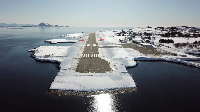
Aircraft shall only carry goods which:

 1       Can be imported/exported free of tax and duties according to existing rules of
         exceptions from these Regulations

 2       Are not included in the import/export restrictions, and not require clearance.

Norwegian International Airports
* Special conditions for ights to Svalbard:
Svalbard is a part of Norway, but outside the Norwegian customs territory and not
part of the Schengen Area. Air tra c between mainland Norway and Svalbard
must only depart from international airports.
Aircraft without standard certi cate of airworthiness
In accordance with European Civil Aviation Council (ECAC) recommendation INT.S/11-1
Norway accepts       ights over Norwegian territory by homebuilt aircraft with a Non-Standard
Certi cate of Airworthiness or a “permit to            y” issued by the Civil Aviation Authority of
another ECAC member state. The            ight test program must be completed. Aircraft from other
than ECAC member states not holding a standard certi cate of airworthiness or operated on a
“permit to     y must apply for a prior permission to operate within Norwegian airspace.

Permission may be obtained from Civil Aviation Authority.

Contact Civil Aviation Authority Norway
Please send your application to this e-mail address.

            E-MAIL

Non standard - The application shall contain the following information:

              Name, address, phone/telefax and e-mail of the Operator

              Purpose of the     ight

              Area of planned operations

              Timeframe of operations

              Documentation of airworthiness (copy of permit to            y with   ight restrictions and
               ight conditions)

              Certi cate of registration

              Valid maintenance documentation
Relevant pages of      ight manual (Information which verify   ight manual for this
              particular aircraft)

              Certi cate of Insurance

Microlight entering and ying in Norway
In order to cross the border and         y microlight in Norway, you will need a permission from
Civil Aviation Authority – Norway.

Permission may be obtained from Civil Aviation Authority,

Contact Civil Aviation Authority Norway
Please send your application to this e-mail address.

            E-MAIL

UL - The application shall contain the following information:

              Name, address, phone/telefax and e-mail of the Operator

              Purpose of the     ight.

              Area of planned operations

              Timeframe of operations

              Certi cate of registration

              Certi cate of Airworthiness
Valid maintenance documentation
Certi cate of Insurance
Pilot license
Medical certi cate
Radio license+ documentation for English language pro ciency
ICAO Flight plan
Aircraft entering Norway has to le a ightplan at least 60 minutes before the departure.
For your own safety, you should always le a ight plan with ATS.
A ight plan may also be led by phone to the national AIS/NOTAM o ce located at ENGM,
tel. (+47) 64 81 90 00.
When calling, be sure to have your completed ight plan handy and ready to read to the AIS-
operator. The ight plan should be delivered within Norway: 30 minutes prior to estimated
time of departure.
A complete ightplan is mandatory for:1 All ights when a national border crossing is required.
2 All ights within EN-R402 (Finnmark).
3 All ights where Search and Rescue (SAR) is requested.
4 Flights to or from Bergen airport, Flesland (ENBR)
5 Flights to or from Oslo airport, Gardermoen (ENGM)
Special requirements for Bergen airport, Flesland
Bergen Flesland ( ENBR)
A complete ICAO FPL is mandatory for all ights (IFR and VFR) to/from the aerodrome. ATC is
authorized to make exemptions from this requirement.
AVINOR.NOPrivate ights (GA) - Avinor Bergen Airport, Flesland appreciate visits by light aircraft and o ers fuel and parking for GA ights (general aviation). Airport Patrol o ers an additional service to the pitches and helping with transportation to and from the terminal. READ MORE AVINOR.NO Special requirments for Oslo airport, Gardermoen
Image courtesy of Avinor
Allocation of departure and arrival times is compulsory for all ights at Oslo
airport, Gardermoen.
The following regulations are in force for both IFR and VFR ights within ENGM CTR:
Carriage and use of SSR transponder is mandatory
A complete ICAO FPL shall be submitted prior to ight
School ights/training ights are not permitted
At Oslo airport, Gardermoen, application for “slot-time” shall be submitted to Avinor
scheduling coordinator: Tel. (+47) 64 81 90 00.Prior permission required (PPR) to land at private air elds
Please note that the majority of air elds and airports, other than those operated by Avinor,
require prior permission for landing or departure. Please check the AIP or providers such as
Jeppesen air eld manual, Skydemon or the air elds' o cial website.
A number of air elds and airport are using a PPR tool called MyPPR, which is available online.
This service may give you an instant permission to land and depart.
MYPPR
MyPPR - ppr made easy
MyPPR - ppr made easy
MyPPR letter arbeidet knyttet til administrasjon av PPR for GA yvning i
Norge for både yplassadminisasjonen og piloten.
READ MORE MYPPR
Parking fees
Avinor have introduced an automatic invoicing system for GA parking. The system registers
aircraft registration, arrival time, o -block time and MTOM. GA aircraft with MTOM 2730 kg
or below are exempt from the parking charges.
GA aircraft with MTOM over 2730 kg are subject to parking charges. A monthly invoice for
parking charges is automatically sent to the aircraft owner.Owners of GA aircraft with MTOM over 2730 kg holding individual agreements regarding
parking arrangements must register their aircraft with the local airport administration to
avoid charges. Other charges for use of the airport will be charged separately.The charge is
based on weight, current price is 15 NOK per 1000 kg per hour. The charge is levied as of the
third hour the aircraft is parked. However, if the parking exceeds two hours, the charge is
reciprocal for the rst two hours as well. Agreements for long-time parking can be arranged
with the local airport administration.
The minimum charge is 125 NOK. All prices include VAT.
AVINOR.NO
Charges - Avinor
The air navigation charges are en route charges and terminal navigation
charges. The charges are for services provided in the airspace for which Avinor
is responsible and the terminal fee for tower services at our airports.
READ MORE AVINOR.NO Animals and pets
No animal may be brought into Norway without an import license from the Norwegian Animal
Health Authorities: Tel: +47 23216800.
MATTILSYNET
Contact us | The Norwegian Food Safety Authority
Norwegian Food Safety Authority
READ MORE MATTILSYNET
Flights to Svalbard/Spitsbergen
If you are planning to y to Svalbard/ Spitsbergen, an application has to be submitted to reach
the Civil Aviation Authorities (CAA-Norway) at least two working days prior to the planned
arrival at the islands. Same information required as listed under paragraph about Non-
standard - The application shall contain the following information. Please observe that ights for
sight-seeing purposes are prohibited on Svalbard, and private ights may require special
permission from the Governor of Svalbard (Sysselmannen).
Fuel and oil may only be available if arranged speci cally. You shall, when ying over the high
seas, carry a minimum of one portable ELT/PLB, life raft(s) able to carry all occupants,
survival suits, emergency rations, rst aid kits and blankets.Weather conditions at Svalbard can be very unstable and local variations prominent. Reliable
weather reports/info may sometimes be hard to obtain, which calls for considerable attention
while assessing ight conditions in these areas. Larger fjords are often ice-free, even during
winter, due to strong currents. This often results in frost mist and/or low dense fog. During
winter, winds of more than 20 knots will always result in drifting snow, due to the ne-
grained and dry snow. The danger of whiteout is always present. You have to be familiar with
Polar Region navigation when ying in Svalbard and its surroundings.
According to the Norwegian Operational Regulations (BSL D), aircraft operating in Svalbard
and its surroundings shall be of such color that it will give good contrast to over- own
terrain. Otherwise, the aircraft shall be marked with uorescing paint or adhesive folio in
color of red, yellow or orange. On airplanes, these markings shall be placed on both sides of
the wings, airframe or tail section. Total marked area shall not be less than 2 m².
Flying with Ultra-light aircraft to/from Svalbard is prohibited without special permission.Lesson 3 of 8
Flight planning
Every ight must be preceded by a certain amount of
planning. This could begin with determination if you
are t to y. Weather considerations, selection of route
to y, aircraft performance calculations and pre- ight
inspections of the aircraft and its systems.
Always check NOTAMs and if planning to use private air elds, remember to call the
owner for permission to land and to get the latest local air eld information.
Some riskfactors
Aircraft
–
Equipment and maintenance?
Any maintenance problems that should be taken care of?Maintenance and technical services are only available at some air elds and airports.
Independent Part-66 certi cate holders may be available. Please contact the local ying
community of the destination to nd out which services that may be available.
List of approved Part-145 maintenance organizations in Norway
Performance
–
Fuel Consumption, weight and balance, eld elevation and runway length available.
Environment
–
How is the weather?
Day or Night operations?
What type of terrain and air elds are involved?
Many areas in Norway o ers very few or limited options to make a successful forced
landing. Water temperatures are often close to zero. Without the right equipment and
training, ditching at sea leaves you with a very low possibility for survival.
External pressure
–
Why are you making the trip?
Limited on time or demanding passengers?
Have you prepared an alternative travel plan before you begin the trip?Types of Manuals and Charts Available for Norway FIR
Aeronautical Information Publication (AIP) Norway in English is available at:
AVINOR.NO
Current AIP - Avinor
Aeronautical Information Publication Norway
READ MORE AVINOR.NO
IPPC – Internet Pilot Planning Center:
This is the internet address for Avinor’s web-based information and ight planning tool.
The site is linked to NAIS, Norwegian Aeronautical Information System. Here you can obtain
brie ngs, weather reports and forecasts, map-updates and also check AIP-Norway online.IPPC
IPPC - Norwegian Aerodrome Info
READ MORE IPPC
Aeronautical Chart ICAO, 1:500 000
These charts are often preferred by pilots for VFR cross-country ights.
3 charts covering Norway:
Southern Norway
Central Norway
Northern Norway
M517 Air Aeronautical Charts, 1:250 000Provides higher detail level. 16
charts covering Norway:
Provides higher detail level. 16 charts covering Norway:
Kristiansand Namsos
Bergen Mosjøen
Rjukan Bodø
Oslo NarvikFørde Tromsø
Otta Kautokeino
Molde Hammerfest
Trondheim Kirkenes
Chart updates
At www.ippc.no, under AIS publications –CHAD NOR, you will nd the latest chart updates for
1:500 000, and 1:250 000 series.
CAUTION: Please beware of obstacles that might not be shown on your map. Masts and
high- tension power lines are constantly being build and caution is especially advised
when ying along fjords, valleys and in the vicinity of islands along the coast. Especially
power lines are almost impossible to see, and they frequently cross fjords and inlets.
Electronic ightbag
The technological evolution has introduced several types of electronic equipment for aiding
the pilot during ight. Most aircraft today are equipped with some type of GPS for aiding in
navigation, and several types of situational awareness systems are being introduced in even
the smallest of aircraft.
For permanently installed equipment, updating procedures are usually in place, while that may
not be the case for non-permanent equipment. Several types of handheld pads are available
with software and apps, that you as the pilot, must keep updated. Although these solutions
may work excellently for most situations, please have a backup in case your primary solution
fails. It is good airmanship to y well prepared.Fuel planning
An operator of an aircraft must take all necessary steps to ensure that the aircraft is carrying
su cient fuel and oil for the planned ight. The regulations require that you have enough
fuel onboard to y to your destination and then for 30 minutes. Especially in the northern
parts of Norway 100LL fuel is only available at some airports. You may call the airport before
departure and please check NOTAM and AIP if desired fuel is available at your destination and
planned alternates.
CAA-Norway recommends the following practice to achieve safe fuel planning:
Make sure you know the total fuel capacity and usable fuel available of your
aircraft.
Check weight and balance, you might not be able to depart with full tanks.
Determine fuel consumption and make sure you take any headwind component
into consideration as well.
Check NOTAMS to make sure you know the status of fuel supply on aerodromes
along your route. Note that opening hours for fueling may vary from ATS opening
hours. Also, note that 100LL might not be available on all destinations.
Always plan to arrive with your fuel reserve intact, never plan to use any reserve to
get to your destination.
Keep the weather in mind, sudden changes are common in Norway. Holding or
diversion might become necessary. Make sure you are prepared for this
eventuality.
Available fuel facilitiesAIRBP Air BP Customer Portal We have placed cookies on your computer to help make this website better. You can change your cookie settings at any time. Otherwise, we'll assume you're OK to continue. READ MORE AIRBP AFSN Aviation Fuelling Services Norway - Home The Shell Carnet card is o ered to our global and regional carrier customers and military customers and is designed to help you fully leverage our network of airports wordwide. READ MORE AFSN VFR-minimum visibility and distance from clouds
Airspace - Flight visibility and distances from clouds

(***) Flight visibilities          3. Helicopter can operate in less than 1500 m but not less
reduced to not less than 1500      than 800 m     ight visibility, if maneuvered at a speed that will
m may be permitted for             give adequate opportunity to observe other tra      c or any
 ights operating:                  obstacles in time to avoid collision. Flight visibilities lower
                                   than 800 m may be permitted for special cases, such as
                                   medical   ights search and rescue operations and
1. At speed of 140 kts IAS or
                                    re ghting.
less to give adequate
opportunity to observe other
tra c or any obstacles in
time to avoid a collision;
2. Or, in circumstances in
which the probability of
encounters with other tra c
would normally be low, e.g in
areas of low volume tra c
and for aerial work at low
levels;
Weather minima for Special VFR Flights
Upon request to TWR, a clearance to y special-VFR within the CTR may be obtained,
provided:
Day or night conditions
The ground and ight visibility is not less than 1500 m, for helicopters, not less
than 800 m.
the speed does not exceed 140 kts IAS.
intention is to conduct the whole ight within the control zone.
intention is to enter the control zone and land at the aerodrome within the
control zone.
VFR nightVFR night over Nordland During the period between the end of evening civil twilight and the beginning of morning civil twilight, VFR night can be done according to SERA 5005 c. Civil twilight summary for Norwegian airports may be generated at www.civiltwilight.me VFR on top Due to the possibility of an engine failure while ying VFR on top in a single engine aircraft, you should always be certain that the cloud base is equal to or higher than Minimum Safe Altitude (MSA) and a minimum of 10 nm either side of your planned route is recommended. We strongly advise you to have some current IFR-training in case you get stuck VFR on top. The weather in Norway changes rapidly and the weather forecast is no guarantee that you will have VFR-conditions when you arrive at your destination.
To calculate your MSA on the ICAO 1:500 000 chart, you should add 1000 ft to the published
Maximum Elevation height (printed in each quadrangle) along your route. This will give you a
safety margin of 1000 ft above the highest obstacle including any unmarked obstacles.

Weather information
As a pilot today, you have a lot of sources for weather information. O   cial aviation weather
information services are available in Norway. In addition we recommend the use of webcams
and weather information available at Windy.com

       WINDY.COM/
Windy as forecasted
Weather radar, wind and waves forecast for kiters, surfers, paragliders, pilots,
sailors and anyone else. Worldwide animated weather map, with easy to use
layers and precise spot forecast. METAR, TAF and NOTAMs for any airport in
the World. SYNOP codes from weather stations and buoys.
READ MORE WINDY.COM/
Pre- ight Met Brie ng
Met brie ngs can be obtained from the following three MWO’s:
Oslo tel. (+47) 22 69 25 62
Bergen tel. (+47) 55 23 66 50
Tromsø tel. (+47) 77 62 13 00
In addition the following local MET o ces are available:
Bardufoss - ENDU (+47) 67 03 44 85
Bodø - ENBO (+47) 75 53 72 80
METAR, TAF,SIG-WX, SIGMET, ICE AIRMET, IGA-prognosis and NOTAMS can be obtained
from all ATS-units. RMK: IGA-prog, a special forecast provided mainly for VFR- ights below FL100, are
available for most areas of Norway.
ATS units are connected to the Norwegian Aeronautical Information System (NAIS), which
means that NOTAMs and various AIS and MET bulletins, including the special area forecasts
for lowland, coast and fjord districts of Norway (IGA-forecast), are provided by all ATS units.
Planning information is also available via internet: www.ippc.no
Autometar
The use of Autometar is approved by CAA-Norway on airports where the AWOS - Automatic
Weather Observation System is currently used. This is an automatic weather report based on
the AWOS observations and used outside the ATS unit opening hours.
In non-signi cant weather conditions there are normally not any di erences between
Autometar and manual Metar.
In signi cant weather conditions there are quite often di erences between measured and
actual visibility, both horizontal and vertical, and in the present of the weather phenomena.
The following codes are used exclusively by Autometar and will not occur on the o cial
Metar: The su x /// is used after all clouds, i.e: FEW040///
NCD – No Clouds Detected
NDV – No Directional Variations UP – Unidenti ed Precipitation
An Autometar will always be identi ed by the term AUTO, i.e:
ENAL 060250Z AUTO 24010KT 9999...
ICAO Flight plan
For your own safety, you should always le a ight plan with ATS.
A ight plan may also be led by phone to the national AIS/NOTAM o ce located at ENGM,tel. (+47) 64 81 90 00. When calling, be sure to have your completed FPL handy and ready to
read to the AIS-operator.
The FPL should be delivered no later than 60 minutes before EOBT.
EUROCONTROL
Flight Plan Guide: Search items
The Flight Plan Guide allows users to search for the correct format to be used
for the di erent elds of the new ICAO Flight Plan via a database.
READ MORE EUROCONTROL
Filing a ightplan via ippc.no:
For access to the ight planning tool you need a username and password.
You choose the username and password yourself and apply for access by completing and
submitting the form under “Logon to Flightplanning – New User” window at IPPC. This is
subsequently authorized by the AIS-o ce located at Oslo-Gardermoen airport.
Due to capacity limitations in the ight plan processing, foreign users will be granted access
for a limited time, and only ight plans into, out of or within Norway will be accepted.
Taking o or landing on airstrips without a four letter ICAO designator; eld 13 and/ or 16.
Departure and/ or arrival aerodromes without an ICAO 4-letter code shall be led in a FPL as
follows:IPPC
IPPC - Norwegian Aerodrome Info
READ MORE IPPC
1 If the ight departs from an aerodrome without an ICAO 4-letter code, ZZZZ shall
be entered in eld 13 in the FPL. Enter DEP/ followed by geographical name and
lat/long
2 position in eld 18 of the FPL.
3 If the ight arrives at an aerodrome without an ICAO 4-letter code, ZZZZ shall be
entered in eld 16 of the FPL. Enter ARR/ followed by geographical name and
lat/long position in eld 18 of the FPL
4 If alternate aerodrome(s) without an ICAO 4-letter code are led, ZZZZ shall be
entered in eld 16 of the FPL. Enter ALTN/ followed by geographical name and
lat/long position in eld 18 of the FPL. If more than one alternate is led in the
FPL, use ALTN1/ and/or ALTN2/ respectively.
Routing; eld 15
Although legal, the use of DCT in the route- eld is not recommended.
ATC prefers to have a reasonable clue as to where you intend to y and i.e an approach
controller will not necessarily know exactly where you will enter a TMA if you are on a long
DCT route between two other airports and happens to transit a TMA in between.
Of course, you may still y on a direct track, but please le a point on the route for at least
every 30 mins. ight time. This can be led either a geographical name, a lat/long position, a
Navaid, a ve-letter Sigpoint or a x given as a VOR radial and DME. (I.e. FLO065040 –a point
on FLO radial 065 at DME 40 from FLO.) DO NOT use the four-letter ICAO designator for airports you over y along the route as a
point in the routing led under item 15 in the ight plan. This is to avoid confusion as to
whether you will be landing at these airports. Please use a navaid at the airport or the
airport name in the routing. The term “coastwise” will sometimes be used by both ATC
and pilots to describe a routing along the coast. In some cases, this may be very accurate,
but due to the number of fjords, inlets and islands along Norway’s coastline we would like
you to le a few points along the route instead. Thereby we avoid confusion about your
intended route
Changing the EOBT
If you like to bring your EOBT forward or delay your ight plan, this is not a problem. Notify
ATC or call AIS (tel. (+47) 64 81 90 00 (H24)) if you change the EOBT more than 30 mins.
either way.
Please bear in mind that some airports are slot-restricted and make sure your slot time is
adjusted accordingly.
Departure message
Departing from an air eld where ATS is not provided, the pilot must transmit a departure
message by one of the following means:
Telephone from a person on the ground as arranged between the pilot-in-
command and the person involved.
A statement by the pilot-in-command that EOBT (Estimated O block Time) in
the ight plan shall be considered as ATD.
By giving the time, considered to be ATD, to AIS/ NOTAM by phone immediately
prior to departure. (tel. (+47) 64 81 90 00)By radio to ATS after departure.
The ight plan will not be activated unless a departure message has been received by ATS.
Delays and/or changes to ightplan
If a delay of more than 30 mins. occur or you have to make a planned change to your FPL,
notify the local ATS-unit or AIS/NOTAM in order to send a DLA or CHG message.
Arrival report
Arrival report and closure of the ight plan must be made within 30 minutes after ETA. If you
don't send an arrival report or close your ight plan, the SAR procedures will be initiated. If
an arrival report is not expected to reach the appropriate ATS unit within 30 minutes after
ETA, item 18 in the ight plan shall contain the latest time at which an arrival report can be
expected. The pilot or the operator may be charged for the total costs of SAR operations if the
pilot has failed to comply with the appropriate rules for noti cation to ATC of:
Deviations from the ight plan, or
Not closing the ight plan will initiate SAR.
You may close the ight plan with any ATC unit on the radio or by phone. Call (+47) 64 81
90 00 to close your plan. If you land at an airport with active AFIS or ATC, your ight plan
will be closed automatically.
Note: If you are planning to use Oslo airport, Gardermoen, allocation of departure and
arrival times (Slot time) are compulsory. Application for slot time for AD Hoc business,
MIL and general aviation ights shall be submitted to Avinor scheduling coordinator:
Tel: (+47) 64 81 90 00
E-mail: ais@avinor.noLesson 4 of 8
Airspace, communication and reporting
Airspace
Norway has class C, D, and G airspace. Class E and F are not in use. Separation from other
aircraft remains the responsibility of the pilot in command of a VFR ight. The exception to
this applies in class C airspace – where ATC will separate VFR from IFR but not VFR from VFR.
When ying through class C and D airspace it is mandatory to obtain an ATC clearance.
Prior to entering class C and/ or D airspace you will need a clearance from the appropriate
ATC unit. This clearance is valid until leaving controlled airspace or reaching the clearance
limit (the point or area to which an aircraft is granted an air tra c control clearance) issued
by the appropriate ATC-unit.
NOTE: Prior to departure, TWR will issue a clearance to leave the CTR. This will
normally contain a routing, altitude limit and a transponder code. This is NOT a departure
clearance or clearance to enter any taxiways or runwaysImage courtesy of Avinor Operations in class C and D airspace outside ATC operational hours Established as Terminal Control Area (TMA) A clearance to operate in class C or D airspace, established as a TMA, outside the published hours of service of the ATC unit normally providing service within the airspace, may be obtained from the appropriate ACC. Use of aerodromes outside published opening hours Most of the aerodromes are available outside published opening hours for non-commercial ights, but speci c terms and conditions apply. The PIC must hold a valid Avinor ID card (PFLY) and submit a ight plan. The ight must be in accordance with VFR during the period of 0700 – 2300 local time. Maximum take-o mass of the aircraft must not exceed 2730 KG.
The aerodrome will normally not be manned outside published opening hours. It is the pilots'
responsibility to conduct the ight in a safe manner. See BSL D 1-2 4-1 and Part-NCO,
NCO.OP.100, Use of aerodromes and operating sites. The permit only allows for take o and
landing, alternatively touch and go. Use of an aerodrome as destination must be conducted
during published opening hours and aircraft parking must be arranged prior to arrival at most
airports. ENGM, ENZV, ENBR, ENVA, ENTC, ENSB and ENVR are not included in the PFLY
agreement and use of aerodromes outside published opening hours.
AVINOR.NO
ID card - Avinor
Her kan du søke om adgangsbevis til en eller ere av Avinors lufthavner.
READ MORE AVINOR.NO
Contact ID-of ce
In case of questions, please contact the AD in question or send an e-mail with subject “Outside HR of OPR”.
E-MAILRadio mandatory zone ( RMZ) Tra c Information Area (TIA), Tra c Information Zones (TIZ) and Control Zones (CTR) outside the opening hours of the ATC-units are classi ed as RMZ. Pilots shall maintain continuous air-ground voice communication watch and establish two-way communication, as necessary, on the appropriate communication channel when ying inside Radio Mandatory Zones. Before entering a radio mandatory zone, an initial call containing the designator of the station being called, call sign, type of aircraft, position, level, the intentions of the ight and other information as prescribed by the competent authority, shall be made by pilots on the appropriate communication channel. Outside the opening hours of the ATC unit, you are not permitted to take o or land at controlled aerodromes unless you have obtained an ATC clearance or have a PFLY permit. Operations within a CTR between the end of evening civil twilight and the beginning of morning civil twilight require clearance from appropriate ATC unit. Aerodrome Flight Information Service (AFIS) Norway has an AFIS network of smaller airports serving thousands of ights and passengers each year. These airports provide AFIS, but must not be confused with simpler "unicom" information services operated at smaller General Aviation elsewhere in Europe. Here you will be operating alongside commercial air transport, and some of the airports are quite busy. You can also read about these airports in the chapter; Tips for safe operations.
Stokmarknes/Skagen AFIS

Tra   c Information Areas (TIA) and Tra     c Information Zones (TIZ), both G-class airspace,
are established at airports where the tra   c is relatively light and therefore only AFIS is
provided (call sign + INFORMATION). Hence, the responsibility for avoiding collisions solely
rests with the pilots when   ying in to or out of these airports. A PFLY ID card is required for
operations outside airport opening hours.

Two-way radio contact with AFIS is mandatory.

The AFIS unit will state runway in use, weather conditions and tra      c information.
Phraseology at airports where AFIS is provided
An AFIS unit shall be identi ed by the name of the aerodrome followed by the word
INFORMATION, e.g. VALAN INFORMATION. At airports where AFIS is established, the AFIS
unit shall use relevant phraseology from ICAO Doc 4444, PANS-ATM Chapter 12 and BSL G 8-
1. When AFIS relays ATC-clearances the name of the ATC unit shall be included. Requirements
for read-back to an AFIS-unit are described in BSL G 8-1, reference is made to AIP GEN 3.3 In
addition, the following phraseologies are available:

            RUNWAY IN USE (number)

            RUNWAY FREE

            RUNWAY OCCUPIED (reason)
(reason for why the runway is not free) RUNWAY AVAILABLE FOR LINE UP (or
TAXI, or TOWING)
REPORT POSITION (or ALTITUDE, or LEVEL)
REPORT PASSING (altitude)
Phraseologies used exclusively while ying at an AFIS aerodrome: “RUNWAY FREE” indicates
that the runway is visually checked free of other tra c and usable for taxiing, takeo or
landing.
“RUNWAY OCCUPIED” indicates that the runway is occupied by other tra c and not usable
for taxiing, takeo or landing.
VFR routes inside CTR
These published VFR-routes are to be used for ight planning purposes and the clearances
issued will state the reporting points to identify the route.
The cleared route with speci ed altitude limitations and related procedures shall be complied
with unless weather conditions necessitate to divert from the clearance.
The diversion or need for a diversion from the clearance shall be transmitted to ATC as soon
as possible.
Prohibited, restricted and danger areas
Prohibited Areas
Prohibited areas are not established in Norwegian airspace.Restricted Areas
Restricted areas and restricted areas which are active only as noti ed by NOTAM are
promulgated in AIP Norway.
Restrictions concerning EN R402 - Finnmark County
Image courtesy of SkyDemon
Non-scheduled and private ights may only take place within the area (displayed east of the
red line) provided a complete ight plan has been led prior to departure. The route to be
own must be speci ed. For VFR- ights entirely within the CTR or TIZ only, it is su cientto give the ATS-unit information regarding the ight prior to departure. VFR- ights
operating entirely within the TIZ outside ATS opening hours may do so, given certain criteria
have been ful lled and prior permission has been arranged with Norway ACC: (+47) 75 58 29
57
Danger Areas
Danger areas which are continuously active, and danger areas which are active only as
noti ed by NOTAM - are promulgated in AIP Norway. In other cases danger areas are
promulgated by NOTAM only.
Based on information given by the agency responsible for the activity, the upper limits of
danger areas are promulgated as:
an altitude (FT AMSL), when the upper limit is at 10000 FT or below, or
a ight level (FL), when the upper limit is above 10000 FT.
By promulgation of the upper limits as a ight level (see para b above) due regard is taken to
possible deviations from the standard atmosphere. The promulgated upper limit of a danger
area can always be considered as safe.
In addition to the upper limit of the activity, a “bu er” of 1000 FT (2000 FT above 25000 FT)
is included. It is the pilots responsibility to avoid all danger areas, however ATC can give
advise and guidance regarding the circumnavigation of these.
ATC will also order a stop in the activity if a controlled ight has to be cleared closer to a
danger area than the prescribed minimum.Real time activation
For some of the danger areas - promulgated as continuously active - a real-time activation is
practiced. Hence all activity in the danger area concerned is coordinated between ATC and the
agency responsible for the activity.
The agency responsible for the activity will inform ATC prior to the activation. Based on this
information, ATC will always be able to inform the pilot in command regarding the status of a
real-time activated area, whether it is active or non-active.
Information regarding a non-active area is valid for a limited period of time only, normally 30
minutes.
Unless the pilot has obtained information on a danger area being non-active, the area shall be
considered as continuously active within the promulgated time period.
Danger Areas - Continuously active See AIP Norway ENR 5-1
Protection of wildlife and sensitive areas
Several protected areas are established to preserve and safeguard vulnerable and threatened
ecosystems and wildlife. Motor vehicles, including landing and departure with aircraft are
generally forbidden in protected areas. In very sensitive areas a higher minimum altitude has
also been established.
Language requirementsThe use of standard phrases for radiotelephony communication between aircraft and ground
stations is essential to avoid misunderstanding. Users of airband radios are required to hold a
valid Radio Telephone license. These documents shall con rm the language pro ciency level
equal to ICAO standards. The primary language for aviation communication is English, but
Norwegian may also be used.
SSR Transponder
Transponder equipped VFR ights shall select code 7000 unless otherwise instructed by the
appropriate air tra c services unit. SSR transponder mode S is not mandatory in Norway, but
if you carry a transponder you shall have it on. Always use Mode C for vertical separation
purposes.
Transponder operating procedures
When an aircraft carries a serviceable transponder, the pilot shall operate the transponder at
all times during a ight, regardless of whether the aircraft is within or outside airspace where
SSR is used for ATS purposes.
Except for emergency or communication failure, the pilot shall:
1 Operate the transponder and select codes as individually directed by the ATS unit
with which contact is being made.
2 Unless otherwise directed by ATS, operate the transponder on the last assigned
code, until aircraft has landed.
3 In the absence of any ATS directions, select code as follows: VFR- ights:
Code 7000.When the aircraft carries serviceable Mode C equipment, the pilot shall continuously operate this mode, unless otherwise directed by ATS. If you are ying in a formation, only the formation leader shall operate the transponder, unless otherwise directed by ATS. Pilots shall not SQUAWK IDENT unless requested by ATS. Emergency procedures The pilot of an aircraft encountering a state of emergency shall set the transponder to Code 7700 except when previously directed by ATS to operate the transponder on a speci ed code. In the latter case, the pilot shall maintain the speci ed code unless otherwise instructed. Notwithstanding the procedures above, a pilot may select Code 7700 whenever there is a speci c reason to believe that this would be the best course of action. Communication failure procedures The pilot of an aircraft losing two-way communications shall set the transponder to Code 7600. Note: A controller observing a response on the communications failure code 7600 will ascertain the extent of the failure by instructing the pilot to SQUAWK IDENT or to change code. Where it is determined that the aircraft receiver is functioning, further control of the aircraft will be continued using code changes or IDENT transmission to acknowledge the receipt of clearances issued. VFR- ights under Oslo TMA
Image courtesy of SkyDemon

When     ying in the G-class airspace underneath Oslo TMA close to Oslo city you should tune
in frequency 122.000 MHz and transmit call sign, position, altitude and intentions blind on
that frequency. For more information (in Norwegian only) AIC-N 21/13.

122.000 MHz is a Unicom pilot-to-pilot frequency and there is no ATS-service provided.
Beware of the restriction area R 102 over the city center. Tune to the appropriate local
frequency when approaching local air elds.

Use of frequency 123.500 MHz
Pilots   ying in G-class airspace are strongly recommended to use 123.500 MHz unicom
frequency for blind reporting. This frequency is used all over Norway outside controlled
airspace. Always make sure you change to the appropriate ATS frequency before entering
controlled airspace or a TIA or TIZ.
Airspace Infringement
Unknown aircraft stray into some of the busiest areas of Europe’s airspace at least once a day.
To avoid that you cause airspace infringement, the following recommendations, based on
good airmanship and common sense, should be considered:

EASA - Avoid airspace infringement

Planning

           Plan your   ight! Where possible, avoid   ying close to controlled airspace
           boundaries. A small navigational error or distraction of any sort may lead to an
           infringement.

           Read NOTAMs and check weather charts closely. The weather changes rapidly in
           Norway, and pilot workload rises rapidly in bad weather.
File a ight plan – an opened FPL is mandatory to receive SAR services.
If your aircraft carries a GPS, be sure to have current electronic maps and latest
update available.
Have updated charts available for the planned ight.
Communication
You are more than welcome to contact Air Tra c Services, even in uncontrolled
airspace. If communication is established, you’ll get ight
information and may request to be transferred to the next ATS unit when
approaching sector boundaries.
Communication established well in advance facilitates a request to enter
controlled airspace as well as makes it easier to get assistance for example, if the
weather deteriorates.
Phraseology and clearance
Use standard phraseology.
Your rst transmission should be e.g.: ”Kjevik Tower – D-EEMH – on VFR ight
plan.” This gives ATS time to nd your ight plan in the system and generate an
SSR code for your ight.
If there is any doubt whether you have received a clearance to enter controlled
airspace or not – ask for con rmation.
If you need to deviate from your clearance to remain VMC – Take necessary action
immediately, but advise ATC as early as possible. STAND BY is not a clearance to
enter controlled airspace. Be aware that a clearance through controlled airspacemay take you away from your planned route, due to tra c patterns and other
tra c.
Transponder
Use the transponder, it will help ATC identify you in case you need assistance and may also
prevent an infringement.
Mandatory Occurrence reporting
REGULATION (EU) No 376/2014 covers everything regarding occurrence reporting and is now
in e ect in the European Union, Norway and some other countries as well. Who, What, When
and How is clearly stated in the regulation. Here we focus on the key content that applies to
General Aviation.
Who – is required to report
All occurrences that have taken place under commercial operation shall be reported via own
organization. But as a private pilot, you shall report occurrences directly to the state of your
pilot’s license. However, in some cases, the country in which the occurrence took place would
appreciate a copy of the report. In Norway, please send a copy to e-mail
NF-2007@CAA.NO.
Occurrences that are important in this context are especially matters regarding tra c
con icts and deviations from clearances and/or procedures. Also, we appreciate reports on
occurrences involving Norwegian aircraft (your own or other’s).
What – shall be reported
Occurrence Reporting is considered in two categories: MOR, mandatory, and VOR, voluntary.
These are only di erentiated when deciding if you are required to submit a report.If your occurrence is covered in the mandatory list, you shall report it. General aviation is
covered in Annex 5 (starts at page 14) of the Regulation. For manual lookup, the document
name is: “IMPLEMENTING REGULATION (EU) 2015/1018.” Sanctions are available if the
reporting requirements are not met. If your occurrence is not covered by the mandatory list,
but you consider it to be a hazard or to have had an impact on safety, you should also le a
report.
How – to le a report
http://www.aviationreporting.eu/ is normally a good start if you are new to reporting. This
portal will guide you to the appropriate reporting destination for your state of license.
AVIATIONREPORTING
EU Aviation Safety Reporting: Home
READ MORE AVIATIONREPORTING You can always go directly if you know where to le the report. In Norway, for example, it links to the state portal www.altinn.no form: “NF2007”. Other countries link to their method of reporting.. How soon – the report must be led From the time of the occurrence, you have 72 hours to le the report to the appropriate authority. It is highly recommended that you immediately write down a description of the occurrence to not forget the details. The human memory about details fades quickly. Why – occurrence reporting First of all, it is the law. But more importantly, there is a need to learn from accidents and incidents so as to take appropriate action to prevent the repetition of such events. Apparently minor occurrences are also important, in order to prevent catalysts for major accidents. Analysis and investigations are necessary and e ective means of improving safety, by learning the appropriate lessons from occurrences and adopting preventative actions. Just Culture This means that you are protected from sanctions and repercussions by ling a report. Note that this does not apply, and sanctions are available if occurrences are unreported. Read more about just culture on the webpage: www.aviationreporting.eu. What will the information be used for? Occurrence reporting is essential in the work to improve aviation safety. Filed reports are subject to con dentiality, and are not available to the media or other parties in aviation (or elsewhere). Reported occurrences will be made anonymous and led in the national databases, where they will be included in statistics and summaries to improve aviation safety. Accidents and serious incidents will be investigated by the Accident Investigation Board in the country of occurrence.
Aeronautical information
Where to nd information: Norway Aeronautical Information Publication (Norway AIP) Static
information, updated every 28 days, containing information of lasting (permanent) character
essential to air navigation:
1 GEN - General operational, legal and administrative information.
2 ENR - En-route airspace information, including airspace classi cations and types
of airspace or airspace restrictions, operation of equipment, etc
3 AD - Information pertaining to Norway licensed aerodromes.
AVINOR.NO
Current AIP - Avinor
Aeronautical Information Publication Norway
READ MORE AVINOR.NO AIP Supplements
Temporary changes to the AIP, usually of long duration, containing comprehensive text
and/or graphics
Aeronautical Information Circulars (AICs)
AICs are notices relating to safety, navigation, technical, administrative or legal matters.
These are issued whenever it is necessary to promulgate information that does not qualify for
inclusion in the AIP or as an AIP supplement. Circulars are published on Thursdays every 28
days.
LUFTFARTSTILSYNET
AIC I
Aeronautical Information Circular (AIC). A notice containing information that
does not qualify for the origination of a NOTAM or for inclusion in the AIP, but
which relates to ight safety, air navigation, technical, administrative or
legislative matters.
READ MORE LUFTFARTSTILSYNET
LUFTFARTSTILSYNET
AIC-N
Luftfartstilsynet publiserer meldinger i form av AIC (Aeronautical
Information Circular). AIC publiseres i to serier: AIC N for meldinger til norskeaktører og AIC I for meldinger til internasjonale aktører. Disse meldingene inneholder informasjon som ikke har et innhold som gjør det nødvendig å publisere NOTAM eller oppdatering av AIP (Aeronautical Information Publication), men som inneholder tema knyttet til ysikkerhet, navigasjon, eller tekniske, administrative og juridiske forhold. READ MORE LUFTFARTSTILSYNET
Lesson 5 of 8

Tips for safe operations

      Short eld operations
      Norway has a unique system of short air elds operated by scheduled services. These air elds
      are mainly located along the coast from the west coast north of Stavanger to the
      Russian/Norwegian border in the extreme northeast part of the country. On average these
      airports have a runway length of 800 m. They are fully equipped for IFR operations (CAT I
      landings) and AFIS. Pilots should be aware that these airports often had to be constructed in a
      non-standard way due to limitations given by surrounding terrain, obstacles and available
      land area. Safety zones surrounding the runways are often limited. Many of these airports are
      very close to the sea. For some of these airports wind from certain directions cause
      turbulence and downdrafts that can make a    ight impossible or very hazardous. Especially for
      small aircraft with low performance.
AFIS/Short eld airports in Lofoten - Image courtesy of SkyDemon Wind you would consider no problem at other airports might present a very di erent hazard at these airports that often are surrounded by high mountains. You should seek information on local conditions for all of these airports before you go. A few of these airports to mention are Hammerfest, Honningsvaag and Stokka/ Sandnessjøen where certain wind conditions can make a ight an extremely unpleasant experience. We advise you to contact the AIS/NOTAM O ce (Tel. (+47) 64 81 90 00) before departure when operating on the AFIS network of airports. They will transfer your call to the local AFIS unit. They will be able to give you the latest weather updates and how this a ects local ight conditions. Balked Landing lights
Short approach Svolvaer runway 19

On most short    eld airports there are balked yellow landing lights or “Go-around” lights.
They consist of a group of two lights on each side of the runway, normally around 300 M
from the threshold. They give you an indication that more than 1/3 of the runway has been
passed. Unless the A/C is     rmly on the ground a go-around is advised.

Takeoff
Starting and taxi at high-density altitudes are performed as you would at sea level, except you
must lean the mixture signi cantly to avoid fouling the spark plugs. Run-up is also normal
except a full power run-up of non-turbocharged engines should be used to set the right
mixture for takeo    power.

If you are planning to take o    heavy, remember that a 10 percent increase in weight,
increases the stall speed by 5 percent. Since lift-o   speed is generally about 15 percent above
the stall speed, this increase in weight will result in a higher lift-o   speed.
Since your true airspeed increases with increasing density altitude for a given indicated
airspeed (add 2 percent to TAS per 1000 feet of altitude), the visual cues of higher ground
speed on takeo    at a high-density airport can make a pilot rotate too early. You should also
be aware of the temptation to over-rotate to try to compensate for the reduced climb
performance resulting from higher density altitude. As a rule of thumb, you should achieve
lift-o   speed by half runway length. This will give you the option to abort the takeo   at lift-
o   speed if necessary and also give you an adequate airborne distance after rotation to climb
clear of obstacles in front of you. You should also bear in mind that several Norwegian
air elds have sharply rising terrain close by, which during windy conditions could call for a
spiral climb above the air eld instead of a straight climbing departure towards rising terrain.

Wind shear
Most of the wind shear that occurs in Norway during winter are caused by temperature-
inversions at ground level. These wind shears are usually long lasting and may be detected by
measuring the wind at higher levels (mountain peaks) above the runway level.

Wind gauges for this purpose are installed at the following aerodromes:

             ALTA (ENAT)

             BANAK (ENNA)

             BERGEN/Flesland (ENBR)

             HARSTAD/NARVIK/Evenes (ENEV)

             KIRKENES/Høybuktmoen (ENKR)

             MOSJØEN/Kjærstad (ENMS)

             HAMMERFEST (ENFH)
SVALBARD/Longyear (ENSV) In wind shear situations these observations are included in the METARs from the aerodromes. The information is included in ATIS broadcasts at aerodromes where this service has been established. Wind and turbulence
Wind and turbulence forecasts are published for 20 airports in Norway, maps with both

horizontal and vertical presentation. www.ippc.no

Icing
An aircraft shall not take-o   for the purpose of making a   ight into known or expected icing
conditions unless the aircraft is adequately equipped with de-icing or anti-icing equipment of
the type and quantities required to handle such conditions. Please note that in some areas,
like over or nearby larger glaciers as Svartisen or Folgefonna, severe carburetor icing may
occur.

Whiteout and Brightout
If you are going to   y over areas covered by snow or ice you may be exposed to the
phenomenon called whiteout.

Whiteout is a situation where you loose the ability to see surface
texture, shadows and hollows

In conditions where the light is reduced by an overcast sky, the result may be that everything
turns into a   attened white surface. You can easily lose your horizon under such conditions
and the ability to judge height and distance become impossible. Patches of clouds beneath the
overcast sky may also blend in with the background and become invisible. This may result
inadvertently entering IMC conditions and maybe a very dangerous situation during low-level
 ying. This is one reason why you should not try to climb up a snow covered mountain hill or
glacier head on. Bright out will give the same   attening white surface appearance with no
visible de nitions, and happens often when bright sunlight from a clear sky shines on a
white unmarked surface.
If you feel you loose your outside references, immediately initiate a climb, using your
ight instruments to verify a positive climb attitude!
Enroute
Route selection over mountainous terrain does often involves more than drawing a straight
line between your origin and the destination. Wind conditions, cloud base and proper
emergency landing sites along your route, often dictate your route selection. For some areas
in Norway, the only suitable emergency landing sites may be to ditch along the shore in the
fjords.
Therefore, a map study with emergencies in mind, choosing an alternative plan goes hand in
hand with the selection of the main route. Weather conditions along your route must be
checked before take o and monitored constantly to detect deteriorating weather as soon as
possible. Especially during winter, the weather conditions may change extremely quickly,
from a nice sunny day to dense snow showers in a matter of minutes. Some of these extreme
weather conditions, like the Polar Lows, are intense and very hard to forecast. Rapidly
deteriorating weather and windy conditions are what makes mountain ying so challenging
and sometimes dangerous. If you start to feel uncomfortable due to the uncertainty of where
you are, clouds forcing you down, reduced visibility, increasing turbulence or downdrafts, take
action and take precautionary measures.You may turn around and go back or choose an alternate
route, but most importantly, do it in time!
Crossing over water
Flying over water without gliding distance to land involves a high level of risk. Especially in
the northern regions the sea temperature is very low. In case you are planning to y over
water you need to be prepared for a ditching. As pilot in command you are responsible to
ensure to have proper safety equipment available, both for yourself and your passengers.
Cold water robs the body's heat 32 times faster than cold air. Should you nd yourself in the
water, avoid panic. Air trapped in clothing can provide buoyancy as long as you remain still in
the water. Swimming or treading water will greatly increase heat loss and can shorten
survival time by more than 50%.
Exhaustion or
Water temperature Expected Survival Time
Unconsciousness
4–10° C 30–60 minutes 1–3 hours
0–4° C 15–30 minutes 30–90 minutesYou can also read