Grampians Region Climate Adaptation Strategy: Situation Analysis
←
→
Page content transcription
If your browser does not render page correctly, please read the page content below
Grampians Region Climate Adaptation Strategy:
Situation Analysis

Centre for Urban Research
RMIT University
April 2021

Recommended citation: Rickards, L., Butt, A., Richardson, A. and Dunn, K. (2021) Grampians Region Climate
Adaptation Strategy: Situation Analysis. Centre for Urban Research. https://engage.vic.gov.au/grampians-region-
climate-adaptation-strategy
Grampians Region Climate Adaptation Strategy: Situation Analysis

Table of contents

GLOSSARY ..................................................................................................................................... 4

1      INTRODUCTION ..................................................................................................................... 5

1.1       Overview ........................................................................................................................................... 5

1.2       Adaptation Challenges....................................................................................................................... 5

2      THE REGIONAL CONTEXT .................................................................................................... 11

2.1       Population ....................................................................................................................................... 11

2.2       Housing and urbanisation ................................................................................................................ 12

2.3       Biophysical features and water catchments ..................................................................................... 12

2.4       Energy infrastructure ....................................................................................................................... 13

2.5       Transport infrastructure .................................................................................................................. 13

2.6       Economic base ................................................................................................................................. 13

4      ADAPTATION FOCUS – AGRICULTURE ................................................................................ 17

4.1       Introduction .................................................................................................................................... 17

4.2       Existing vulnerabilities and adaptive capacities ............................................................................... 17

4.3       Major climate change risks for agriculture in the Grampians region ................................................. 18

4.4       Key Adaptation Needs and Opportunities ........................................................................................ 20

4.5       Existing adaptation actions .............................................................................................................. 23

4.6       Examples of adaptation from other places....................................................................................... 27

5      ADAPTATION FOCUS – ECONOMY ..................................................................................... 29

5.1       Introduction .................................................................................................................................... 29

5.2       Existing vulnerabilities and adaptive capacities ............................................................................... 29

5.3       Major climate change risks for the Grampians economy .................................................................. 31

5.4       Key adaptation needs ...................................................................................................................... 32

5.5       Existing adaptation actions .............................................................................................................. 33

5.6       Examples of adaptation from other places....................................................................................... 37

                                                                                                                                                        1
Grampians Region Climate Adaptation Strategy: Situation Analysis

6     ADAPTATION FOCUS – MANAGEMENT OF THE NATURAL ENVIRONMENT ...................... 38

6.1      Introduction .................................................................................................................................... 38

6.2      Existing vulnerabilities and adaptive capacities ............................................................................... 38

6.3      Major climate change risks for management of the Grampians’ natural environment ..................... 39

6.4      Key adaptation needs ...................................................................................................................... 40

6.5      Existing adaptation actions .............................................................................................................. 41

6.6      Examples of adaptation from other places....................................................................................... 44

7     ADAPTATION FOCUS – HEALTH & WELLBEING .................................................................. 46

7.1      Introduction .................................................................................................................................... 46

7.2      Existing vulnerabilities and adaptive capacities ............................................................................... 46

7.3      Major climate change risks for Grampians health and wellbeing...................................................... 47

7.4      Key adaptation needs ...................................................................................................................... 48

7.5      Existing adaptation actions .............................................................................................................. 49

7.6      Examples of adaptations from other places ..................................................................................... 51

8     ADAPTATION FOCUS – WATER ........................................................................................... 56

8.1      Introduction .................................................................................................................................... 56

8.2      Existing vulnerabilities and adaptive capacities ............................................................................... 56

8.3      Major climate change risks around water in the Grampians region .................................................. 57

8.4      Key adaptation needs ...................................................................................................................... 58

8.5      Existing adaptation actions .............................................................................................................. 60

8.6      Examples of adaptation from other places....................................................................................... 62

9     HAZARD - HEAT ................................................................................................................... 66

9.1      Climate change projections.............................................................................................................. 66

9.2      Regional hazard vulnerability .......................................................................................................... 66

9.3      Observed impacts of increased heat in the Grampians region .......................................................... 67

9.4      Projected impacts of increased heat in the region: .......................................................................... 67

9.5      Interactions with other hazards ....................................................................................................... 69

9.6      Cross-sectoral adaptation needs ...................................................................................................... 69

                                                                                                                                                     2
Grampians Region Climate Adaptation Strategy: Situation Analysis
10 HAZARD - DROUGHT ....................................................................................................... 70
10.1 Climate change projections.............................................................................................................. 70
10.2 Regional hazard vulnerability .......................................................................................................... 70
10.3 Observed impacts ............................................................................................................................ 71
10.4 Projected impacts in the region ....................................................................................................... 71
10.5 Interactions with other hazards ....................................................................................................... 72
10.6 Cross-sectoral adaptation needs ...................................................................................................... 73
11 HAZARD - FIRE ................................................................................................................. 74
11.1 Climate change projections.............................................................................................................. 74
11.2 Regional hazard vulnerability .......................................................................................................... 74
11.3 Observed impacts ............................................................................................................................ 74
11.4 Projected impacts ............................................................................................................................ 75
11.5 Interactions with other hazards ....................................................................................................... 77
11.6 Cross-sectoral adaptation needs ...................................................................................................... 77
12 HAZARD - FLOOD ............................................................................................................. 78
12.1 Climate change projections.............................................................................................................. 78
12.2 Regional hazard vulnerability .......................................................................................................... 78
12.3 Observed impacts ............................................................................................................................ 78
12.4 Projected impacts ............................................................................................................................ 79
12.5 Interactions with other hazards ....................................................................................................... 80
12.6 Cross-sectoral adaptation needs ...................................................................................................... 80
13 REFERENCES .................................................................................................................... 82
3Grampians Region Climate Adaptation Strategy: Situation Analysis
Glossary
3CA - Community Climate Change Adaptation
ABS – Australian Bureau of Statistics
CMA – Catchment Management Authority
CSOs - Community Service Organisations
DELWP – Department of Environment, Land Water and Planning
DET – Department of Education and Training
GHCMA – Glenelg Hopkins Catchment Management Authority
GRCAS – Grampians Region Climate Adaptation Strategy
ICM - Integrated Catchment Management
IPCC – Intergovernmental Panel on Climate Change
LGA – Local Government Area
NCCMA – North Central Catchment Management Authority
PPWCMA – Port Phillip and Westernport Catchment Management Authority
REZ - Renewable Energy Zone
SES - Socio-Economic Status
WCMA – Wimmera Catchment Management Authority
WSUD – Water Sensitive Urban Design
4Grampians Region Climate Adaptation Strategy: Situation Analysis
1 Introduction
1.1 Overview
This Situation Analysis provides background information for the Grampians Region Climate
Adaptation Strategy (GRCAS). It is designed to complement other work (e.g. the DELWP
Climate Projections) with a methodical analysis of the core Adaptation Themes in the GRCAS.
The Situation Analysis was produced after the Draft GRCAS and takes a slightly different
approach, including separating out the Adaptation Themes in the GRCAS into six sector-
based Adaptation Focus topics (e.g. Agriculture) and five Hazards (e.g. Fire). For each
Adaptation Focus topic, it consistently outlines the existing vulnerabilities and adaptive
capacities of the region (independent of climate change), major climate change risks, key
adaptation needs, existing adaptation actions in the region and other relevant adaptation
actions occurring elsewhere. For each Hazard topic, climate change projections, regional
vulnerability, observed impacts, projected impacts, interactions with other hazards and cross-
sectoral adaptation needs are presented.
As the GRCAS is about the unique Grampians region – in keeping with the ‘place-based
adaptation’ approach encouraged by DELWP (2020a) - the report begins with a brief overview
of relevant aspects of the region. The report also highlights relevant adaptation actions and
research underway in other regions to point to both adaptation possibilities for the region
(noting nothing is directly transferrable), and its adaptation context.
The report does not seek to replicate the 2019 Victorian Climate Projections report and
presumes readers have read it and understand the general nature of climate change, including
its dependence on emissions scenarios and its combination of background trends and
extremes or “hazards”. Each section of this Situation Analysis provides key information in a
structured way, and points to relevant existing work. The approach taken is informed by the
Intergovernmental Panel on Climate Change (IPCC) thinking about climate change risks and
impacts. It should be noted that this approach needs to be complemented with collaborative,
multi-stakeholder processes that collectively explore deeper, and more transformative change
in the region.
To begin, we provide a brief introduction to some key adaptation challenges.
1.2 Adaptation Challenges
This section provides some brief reflections on what climate change adaptation requires. It is
included here as it helps inform the approach taken in the rest of the report.
1.2.1 Conceptualising risk
Climate change risks are caused by altered climatic conditions and/or their flow-on effects
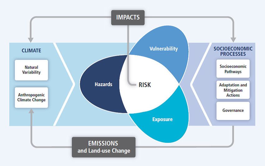
intersecting with other dynamic factors “on the ground”. The IPCC suggests that climate
change risk can be usefully understood as the intersection of a hazard (e.g. bushfire, pest
outbreak), spatial exposure to the hazard (e.g. property in fire zone, being on a road at a
certain moment), and pre-existing vulnerability (e.g. susceptibility of structures to combustion,
lack of social supporti (Figure 1). Risk is dynamic and how, where and to what effect a given
risk manifests as actual impacts can be highly uncertain.
5Grampians Region Climate Adaptation Strategy: Situation Analysis
Figure 1: The IPCC AR5 conceptual framework of climate change risk (IPCC, 2014)
Risk can also be understood as Likelihood x Consequences. Actual consequences and
perception of them differ between groups, who therefore assess risks differently. Further
complexity emerges because risk assessments are not only partly subjective (dependent on
assumptions and points of view) but change as conditions alter (Minteer and Collins, 2010).
For the sake of this report “hazard” refers to a climatic/biophysical stress associated with
climate change. This includes extreme weather events, climatic extremes (e.g. droughts, heat)
and shifts in long term trends, including generally hotter, generally drier and far more variable
weather and climatic conditions (e.g. across an hour, one season, or a decade). While climate
changed-conditions often do not look different in kind from the climate we have experienced
before humans began to affect it by adding extra greenhouse gases to the atmosphere, they
do differ in the intensity, frequency, timing and co-occurrence of different phenomena. Past
rules of thumb about when winter rains begin or how long droughts go for or how storms
behave, for example, are increasingly less reliable. At the same time, climate change is
helping drive the emergence of new climatic phenomena and challenges, such as
pyrocumulonimbus storms generated by bushfires (Dowdy et al. 2017) or thunderstorm
asthma (Campbell et al 2019). Over time, as climate change alters landscapes, hydrological
regimes, ecologies, economies and society in general, and these then interact with altered
climatic conditions, its effects will grow in scope and scale. The aim of adaptation is to make
changes in society as positive as possible in order to reduce negative outcomes.
1.2.2 Existing vulnerability and adaptive capacity
The impact of hazards depends on what existing challenges the group or system in general is
facing (e.g. difficulties posed by COVID-19 pandemic) and thus how well they can cope and
adapt. In the IPCC framework (Figure 1), vulnerability refers to existing, non-climatic
6Grampians Region Climate Adaptation Strategy: Situation Analysis
vulnerabilities. It is a system’s propensity to be adversely affected by an “external” stress or
disruption at a given moment in time. Vulnerability encompasses sensitivity to specific harms
(e.g. an embodied, biological sensitivity to smoke), and more generic factors such as a lack
of financial resources or political representation, or lack of redundancy or flexibility.
Differences in vulnerability mean that any particular hazard event or climate change stressor
affects different systems unevenly and in a time-dependent way (Department of Home Affairs,
2018). Climate change is deepening existing inequalities (e.g. lower socioeconomic groups or
businesses that are highly geared tend to be disproportionately affected by most climate
change stressors) but is also creating new types of risk and disadvantage. For example, some
characteristics presumed to be advantageous until now (e.g. high tech centralised systems)
may prove disadvantageous in some situations (e.g. when there is a systemic infrastructure
failure). High consumption lifestyles can seem desirable, but set people up for greater losses
in the event of a disaster, particularly if people are unaware of the fragility of such systems.
As Bosomworth et al. (2016: 309) found, in Australia:
The country’s strategic emergency managers are […] concerned that the growing
interdependence between infrastructural, social, and technical systems is boosting
vulnerabilities to hazards. Interdependencies between energy, transport, and food
production systems, for instance, mean that the disaster impacts experienced in one
community can affect many other communities Despite the sometimes fragile nature
of essential critical infrastructure services during disaster events, industrialised
societies expect that they will be available during extreme events.
The fragility of critical infrastructure systems illustrates the way that vulnerability needs to be
understood at different scales. Besides the individual and household scale, vulnerabilities exist
at higher social and spatial scales such as watersheds and social-ecological systems,
electricity grids, road networks, governance systems, and global supply chains (Department
of Home Affairs, 2018).
The inverse of vulnerability is adaptive capacity: the ability of systems, institutions, humans
and other organisms to adjust to potential damage, to take advantage of opportunities, or to
respond to consequences (IPCC, 2018). Levels, sources or types of adaptive capacity vary
greatly between individuals, communities, ecosystems, and sectors, and are shaped
dynamically by ever altering contexts. Besides individual capacities (e.g., skills in drought
management), there are many social and environmental variables that shape adaptive
capacities – e.g., access to collective resources, services and infrastructure, as well as levels
of social capital in the form of community cohesion, relationships, and trust.
Some of the skills and capacities needed for adaptation and disaster resilience (e.g.,
electricity-free food preservation methods, mechanical skills, resourcefulness, frugality) are
not those typically valued in society but may be widespread among some marginalised groups
(e.g. elderly migrants) (Head et al. 2021). The complexity and variability of climate change
and its countless flow-on effects means that people will be particularly vulnerable in some
ways and at some times, but in other ways and at other times they will find themselves better
equipped than most.
1.2.3 Different types of impacts
The complex, systemic character of the world means climate change impacts are not just
climatic but encompass:
§ First order risks and impacts are “direct” ones and receive the most attention,
particularly in disaster risk reduction work. This is about the most immediate, tangible
and clearly causal relationships, such as the biophysical effects of increased
temperatures on exposed people, animals, vegetation, water bodies and machinery.
7Grampians Region Climate Adaptation Strategy: Situation Analysis
§ Second order risks and impacts are “indirect” ones, caused by the flow-on effects
of first order impacts. Examples include the additional pressure that a spike in heat-
related illnesses puts on the health system, reducing its ability to provide support.
§ Third order risks and impacts are “distant” ones that originate elsewhere but affect
a region via disruptions to normal flows (e.g. supply chains, commuters, tourists) or
effects on wider systems (e.g. on the national economy or OHS requirements).
Cascading impacts occur when second and third order impacts of various sorts are generated
quickly (e.g. disease and pest outbreaks in the aftermath of a flood). These flow on effects
can then compound initial impacts, by making flood waters unsafe, for example.
The recent Black Summer (2019-2020) demonstrated the range of flow on effects one “event”
can have (Figure x).
1.2.4 Climate change adaptation
Climate change adaptation is about continuously adjusting to unfolding and expected climate
change and its myriad flow-on effects. In human systems, effective adaptation avoids or
moderates these costs and harms and may exploit beneficial opportunities. Human adaptation
efforts can help some natural systems adjust to some effects.
Risk reduction is the dominant paradigm of climate change adaptation. Each of the three
‘petals’ in Figure 1 points to opportunities to reduce climate change risks:
• Reducing the likelihood and consequences of specific hazards (e.g. flood
management works, fuel reduction burning)
• Reducing one’s exposure to a hazard (e.g. via land use planning, evacuation)
• Reducing one’s vulnerability to a hazard event or climate change stressor (e.g. fire,
flood or heat resistant buildings, low reliance on water, strong social support).
Climate change adaptation incorporates a range of objectives and areas of effort. While it
necessarily involves “coping” at any moment in time, it is also about changing now to better
“fit” emerging and future conditions and proactively and positively shaping them.
1.2.4.1 Towards better adaptation
Besides more climate change adaptation, society needs to get better at adapting because ‘not
every response to climate change is a good one’ (Erickson et al 2014) and adaptations that
adequately reduce risk today may not do so in the future. Criteria of ‘’good adaptation” include
the following 5E’s:
§ Effectiveness: how effective was the intervention at reducing potential harm?
§ Efficiency: what time, effort and resources were needed? Could the same outcome have
been achieved more efficiently?
§ Equity: who and what were advantaged or disadvantaged? How inclusive and equitable
were the process and outcomes?
§ Externalities: what risks and harms were generated (e.g. greenhouse gas emissions,
biodiversity losses, community or staff stress and conflict)?
§ Extended time horizon: to what extent does the intervention help adapt a system to not
just the near term but the long-term future? Does it place the system on the right
“adaptation pathway”?
8Grampians Region Climate Adaptation Strategy: Situation Analysis
Adaptation is never perfect or cost-free. The more severe a climatic impact or flow-on effect,
the less likely adaptation will be able to fully avoid or neutralise the harms involved. Adaptation
always leaves a ‘residual risk’ Already it is apparent that even “well managed” extreme events
often involve human fatalities and other losses given the scale and character of the event.
Losses and successes also alter over time and scale.
Adaptation takes effort and resources and comes with an opportunity cost. Yet these costs
are relative. Adaptation will reduce the far larger costs and constraints of inaction, including
the cost of dealing with future disasters in the absence of adaptation. In 2050 the total cost of
disasters in Australia per annum is estimated to jump to $33 billion (up from $9 billion in 2015),
unless steps are taken to reduce risk, increase resilience and adapt to long term changes
(Deloitte Access Economics, 2016). These costs are substantially larger again when far-
reaching indirect losses are included, generating second and third order impacts. Future
financial costs of disasters in Australia may threaten government fiscal stability.
Climate change adaptation actions are unlikely to benefit different groups or environments in
the same way and some can generate new problems or injustices (Bunner & Lynch, 2010).
For example, some efforts to provide farmers with access to seasonal climate forecasts to
help them manage increased climatic variability have inadvertently deepened gender and
class inequities in some farming communities because they are not equally available
(Rickards et al., 2014). Adaptation needs to look ‘beyond simple cause-and-effect
relationships, to identify and address economic, political, social, and technological drivers of
current challenges’ (Rubenstein et al, forthcoming). The inverse of good adaptation is
maladaptation: actions that may lead to increased risk of adverse climate related outcomes,
increased vulnerability to climate change, or diminished welfare, now or in the future (Barnett
& O’Neill, 2010).
1.2.4.2 Types of adaptation
There are many adaptation options available. Some changes are already apparent. Most of
these are incremental (minor changes) and reactive (in response to observed shifts in
conditions). But some adaptations (e.g. the relocation of mainland wineries to cooler climates)
are more transformational (major changes) and anticipatory (initiated prior to the manifestation
of possible impacts). Transformational adaptation includes large scale spatial reorganisation
and landscape changes. Such adaptation has a long lead time (Stafford-Smith, et al., 2011)
and failure to commence them now may mean that the opportunity to pursue them is lost,
especially if adaptive capacity is eroded over time and people are forced into reactionary
coping mode.
Other categories of adaptation include hard adaptations (physical changes, notably protective
structures such as dams or tougher buildings) and soft adaptations (“social” changes such as
alterations in policies, ambitions and relationships, including new building codes, improved
collaboration and new ways of thinking) (Sovacool, 2011). Some adaptations build “specific”
resilience (the capacity to cope with a given (climatic) impact such as fire) while others build
“generic resilience” (the capacity to cope with any disruption or stressor) (van de Merwe et al.,
2018)
As mentioned above, the three components of climate change risk are a good starting point
for thinking about the adaptation approaches available. Adaptations can also tackle first,
second or third order impacts.
9Grampians Region Climate Adaptation Strategy: Situation Analysis
1.2.4.3 Adaptation limits and barriers
Adaptation also faces limits. As climate change worsens, it is likely aggregate impacts will
exceed the capacity of some systems and groups to manage them. For example, some
ecosystems may fundamentally alter as species go locally extinct due to an inability to move
or evolve quickly enough, and humans face biological thermal thresholds as discussed above
(Eisenack et al, 2014). Any individuals’ or groups’ capacity to cope at any one moment varies
over time, dependent on circumstances. Uneven structural vulnerabilities and engrained
issues such as downplaying climate change risks means some groups are continually or
regularly unable to cope or adapt well.
In Australia, climate adaptation and the related field of disaster risk reduction increasingly take
a ‘shared responsibility’ approach in recognition of the fact that everyone, everywhere, needs
to do their part. However, uneven capacity means that caution is needed. Some research
suggests that ‘communities often are left to manage residual risks shifted towards individuals,
whether or not they have the financial, physical, mental, or social capacity to manage them’.
(Deloitte Access Economics, 2016)
Numerous barriers to adapting well need to be overcome (Eisenack et al, 2014). While
knowledge and information are important, analysis of barriers to adaptation suggests that
institutional barriers (e.g., lack of clear mandate, low willingness to act) are often more
significant (Biesbroek et al., 2013). Enablers of good quality adaptation include a collaborative,
learning based approach.
Integrated decision-making is also increasingly recognised as a guiding principle for
adaptation decision-makers, reflecting the pervasive risks climate change poses to all aspects
of society including the social and economic spheres (IPCC 2014). Integrated decision making
is the policy position of the Victorian Government through Victoria’s Climate Change
Adaptation Plan 2017-2020 (DELWP 2016d) and the Climate Change Act 2017 (Vic) 4. It
encourages the systematic mainstreaming of climate change adaptation into existing policies
and decision-making processes. How to do this well itself remains an area where social
learning and high level support (resourcing, coordination, culture change) is needed (Runhaar
et al. 2018).
10Grampians Region Climate Adaptation Strategy: Situation Analysis
2 The Regional Context
The diverse Grampians Region (DELWP) extends from the Wimmera and Victoria's Southern
Mallee region east to include Ballarat, the surrounding Central Highlands and Melbourne’s
western peri-urban areas, encompassing eleven local government areas. It encompasses a
wide range of socio-economic and bio-physical considerations. The region’s characteristics
represent an important context for climate change impacts and adaptation, pointing to some
existing vulnerabilities and adaptive capacities.
Relevant characteristics are as follows:
2.1 Population
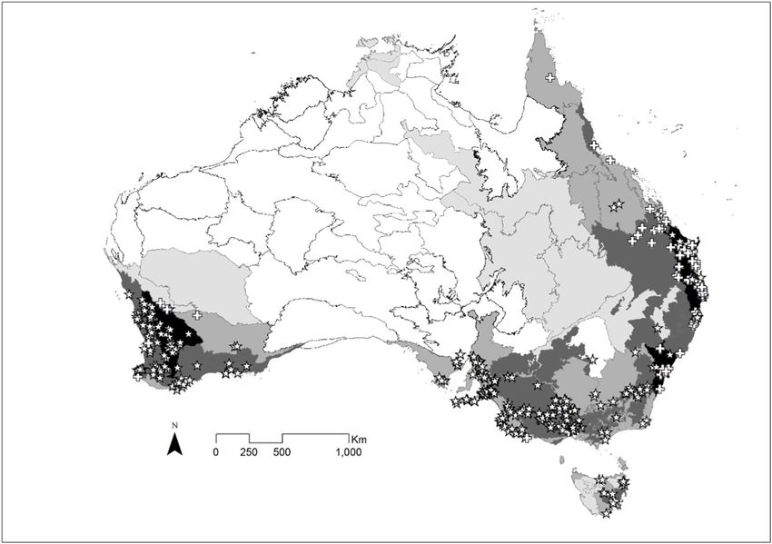
• The Traditional Owners of the Grampians Region extend from the Wotjobualuk people in
the Wimmera region to the western fringes of the Kulin nation – the Registered
Aboriginal Parties are mapped on Figure 2.1 below
• Moderate rates of population growth are evident in the larger regional centres in the west
of the Grampians Region (e.g. Horsham, Stawell and Ararat). There is a long term trend
of population decline and population ageing in many of the smaller towns. This is
coupled with the centralisation of services and employment in fewer centres, leading to
‘stretched’ regional catchments for jobs and services. These regions have experienced
growth well below the Victorian average for decades (ABS, 2020) and the centralisation
of population, coupled with decline is forecast to continue (DELWP, 2019g). The growth
of Horsham has slowed since 2010 and surrounding Wimmera communities have
experienced a reduction in the rate of population decline (ABS, 2020).
• Population projections suggest that over 30% of the population will be aged over 65
years by 2036 in several of the region’s local government areas (DELWP, 2019g). The
ageing of the population is not only occurring in those areas experiencing population
loss. For example, Hepburn Shire is projected to have 35% of the population in this age
group, but this is driven by inward migration, rather than the loss of younger populations
occurring in the Wimmera region (except for Horsham). All local government areas in
the region are projected to have older population profiles than the overall Victorian
population.
• Median household incomes in the region are lower than the overall state population
(ABS, 2017), and this is particularly apparent in the Wimmera region and in Pyrenees
Shire. Average household size is also smaller than across Victoria. Both of these
features are consistent with older population profiles and with static or declining
populations, especially in smaller towns.
• The smaller communities vary considerably in a range of key characteristics – there are
over 30 towns in the region with populations of under 1000 people (ABS, 2017) - and a
greater number of small rural communities. These communities generally have an older
age structure and lower incomes than larger centres (such as Ballarat). This in turn
suggests a varied range of capacities and vulnerabilities in smaller communities as they
plan adaptation to climate change.
11Grampians Region Climate Adaptation Strategy: Situation Analysis
2.2 Housing and urbanisation
• Population and housing growth in Ballarat and the smaller towns in the Central Highlands
are linked to processes of urbanisation and peri-urban housing growth, as well as to trends
in lifestyle, including retirement-aged migration. Rates of housing development in Ballarat
and Moorabool are high and commuting practices increasingly connect this part of the
region to a metropolitan job market. This subregion has experienced population growth in
excess of the Victorian average for the past decade (ABS, 2020). This has resulted in an
increasing diversity of rural land uses (beyond traditional agriculture).
• In many parts of the region there are high housing vacancy rates and low levels of
development. With the exception of Hepburn, this indicates of a slower market and less
investment in new development or renovations, limiting opportunities for adaptive forms of
housing design. In Hepburn, vacancy rates are associated with a tourism economy, and
in consequent impacts on local housing affordability.
2.3 Biophysical features and water catchments
• The region has a diverse set of topographical and biophysical characteristics. The
predominantly hot and dry Wimmera Southern Mallee is characterised by large areas of
cleared cropping land and remnant Mallee vegetation, which is also prominent in some
smaller townscapes. There are some significant areas of high biodiversity value, including
the Grampians, St Arnaud Ranges and Little Desert National Parks, plus State Forests
such as the Wombat and Mt Cole State Parks, areas of remnant grasslands and forests in
the Central Highlands, and Ramsar-listed wetlands such as Lake Albacutya. High levels
of public access to these areas ensure they are valued, but present challenges to their
management. More scattered, relictual native vegetation in agricultural landscapes and
along waterways remains under significant threat.
• The region includes critical water catchments for urban and agricultural use. In the Ballarat
and Central Highlands this includes important potable water catchments for urban, stock
and domestic systems extending beyond the region. Water supplies in the region are
classed as Vulnerable due to their almost complete dependence on rainfall (not
groundwater), notably reliable cool season rainfall and runoff to maintain flow in waterways
(DELWP, 2016a). Capital-intensive systems for urban and agricultural use, such as the
Wimmera Mallee Pipeline, are reliant on rainfall in catchments within and beyond the
region.
• Rivers and creeks, wetlands, lakes and reserves exist across the region, including
Victoria’s largest freshwater lake, Lake Hindmarsh. Northern catchments in the region,
including the main waterway, the Wimmera River, are part of the Murray Darling Basin and
are thus subject to tri-state decisions made about its management. A section of the
Wimmera River is a Victorian Heritage River and is under native title by Traditional
Owners. The upper Wimmera River and its tributaries has been selected as the site of one
of the state’s Flagship Waterways Project that is committed to long term, large scale
restoration. Some lakes and waterways are used heavily for boating and other recreation.
Some have high biodiversity value, locally or further afield, such as creeks in the west of
the region that flow into Ramsar-listed sites in South Australia. Many of the waterways are
already under threat from grazing pressure and other stressors, leading to reduced flows,
sedimentation, gully and land erosion, pest invasion and declining water quality. By
returning some water to the natural waterways, the Wimmera Mallee Pipeline Project has
helped reverse or slow some negative trends.
12Grampians Region Climate Adaptation Strategy: Situation Analysis
• The area overlaps with all of the Wimmera Catchment Management Authority (CMA)
region, and parts of the Mallee, North Central, Corangamite, Port Phillip and Westernport
and the Glenelg Hopkins CMA regions (see https://viccatchments.com.au/about-us/our-
cma-regions/).
2.4 Energy infrastructure
• The region is predominantly reliant for electricity on the major power corridor that connects
Latrobe Valley’s coal-fired power stations to Portland, via Melbourne, including the major
south-north transmission line running from Melbourne to Ballarat to Horsham to Red Cliffs.
• Much of the region is specifically identified as a Renewable Energy Zone (REZ) under
current discussion (DELWP, 2021b). This builds on the development of wind power
developments in recent decades in areas, including Waubra and Ararat. It also includes
scope for large-scale solar in the Wimmera Southern Mallee, although state grid
improvements will be required to fully realise this. Emerging energy landscapes present
opportunities for land owners, but also signal shifting priorities and challenges in some
areas, over and above the need for electricity grid development.
2.5 Transport infrastructure
• Road transport remains dominant for passengers and freight, with most settlements diffuse
and car-dependent. However, improvements to passenger rail since 2005 and several
smaller rail projects that encompass areas within the region, such as standard and dual
gauge rail improvement projects through Ararat and Murtoa over the past decade, mean
that rail transportation is not insignificant. Freight from the region goes to one of three
ports: Portland, Geelong or Melbourne.
• The region has three airports – in Horsham, Stawell and Warracknabeal. Horsham and
Stawell airports are currently being upgraded to improve safety and ensure they are fit for
purpose during emergencies.
2.6 Economic base
2.6.1 Agriculture
• Agriculture is the main land use in the region. The Wimmera Southern Mallee is
characterised by large areas of cleared mainly cropping land (mostly grains, oilseeds and
legumes) with some remnant Mallee vegetation. Central Highlands includes more grazing
(sheep meat, wool, beef) and a wider range of agriculture enterprises, including some
large businesses in Nursery Production and Vegetable Growing (ABS, 2018). In addition
to the continuity of high-value agricultural enterprises in the Central Highlands and
Grampians, including Wagyu Beef, there is now also a proliferation of smaller and sub-
commercial farming operations, notably in beef cattle but also intensive horticulture and
dairy. In the Central Highlands, over half of the farm businesses have an annual turnover
below $200,000, suggesting comparative low farm incomes. Small commercial farm
businesses include mixed organic farms and viticulture, olive, berry and nut production, as
well as small-scale grazing activities.
• Ongoing increases in the scale of agricultural businesses in dryland cropping and grazing
areas across the region, particularly in the Wimmera Southern Mallee. This continues to
lead to fewer, larger farms across most of the region, although different trends are
experienced closer to Ballarat and Melbourne. In this region over 30% of farm businesses
13Grampians Region Climate Adaptation Strategy: Situation Analysis
have a turnover in excess of $500,000 annually, and a higher proportion in the Grains
industry (ABS, 2018).
• Areas of ‘transitional’ farming (Barr, 2009), including traditional sheep grazing areas in
decline, are a feature of several areas in the region, especially those between the peri-
urban regions and the dryland cropping regions. For example, most sheep grazing
business surrounding Avoca and St Arnaud have an annual turnover of below $200,000
(ABS, 2018). In some locations this has resulted in under-investment in land management,
challenges to traditional inter-generational transfer, and a push for the development of
non-agricultural land uses. In the region a number of these areas include landscapes that
feature a land ownership mosaic of post-goldmining public lands, extant forests and areas
of fragmented property ownership.
• Intensive pig and poultry (meat and egg) enterprises are evident in several clusters within
the region, as are food processing facilities, which are a key feature of Ballarat’s
manufacturing economy.
2.6.2 Mining
• The region includes notable areas of active mineral sands extraction in the Wimmera
(including Titanium) as well as the Stawell Goldmine, among other smaller operations.
• The Goldfields part of the region including around Ballarat was heavily mined by small
scale artisanal gold miners in the nineteenth century and into the twentieth century. The
use of mercury and other chemicals was widespread and largely unregulated. Large
amounts of mercury and other heavy metals remain in the soil and have spread throughout
the surrounding environment areas, including urban environments (Abraham et al 2018a,
2018b, Lawrence and Davies 2020).
2.6.3 Services sectors
• Retail and service sector employment is evident throughout the region, with key locations
for government employment and large retail clusters in Ballarat and Horsham. These
sectors, along with health, represent the largest employers in urban areas.
• The Grampians Region is part of the Victorian Department of Education and Training’s
South Western Victoria region (made up of Wimmera South West and Central Highlands
subregions), which has 416 government schools with 173, 434 students (as of Feb 2020).
Rural/remote parts of Victoria are more likely to have difficulty attracting and retaining
teaching staff and in keeping with this the Wimmera South West subregion has one of the
highest levels of primary school teacher attrition and of secondary school rates of unfilled
vacancies. As of Feb 2020, there were 183 and 254 primary school teacher vacancies in
the Wimmera South West and Central Highlands respectively. (DET, 2020).
• In addition to early childhood and school education, the Grampians Region is home to
various further education facilities and four university campuses: Federation University
and Australian Catholic University in Ballarat, Federation University in Horsham, and
University of Melbourne in Creswick. All attract university students and staff to the region
and the University of Melbourne’s Creswick campus offers conference facilities and so
contributes to business tourism in the region. Longerenong agricultural college is an
independent entity near Horsham, including a 1070ha mixed farm and an associated Data
Farm Innovation Centre to trial and showcase digital agricultural technologies and
management.
• The health sector is a significant employer in the region, whether at larger regional facilities
or small, local services in small towns. Health networks in the region include major
hospitals (including Ballarat Base, commencing major redevelopment) as well as localised
networks of community facilities, nursing homes and other services.
14Grampians Region Climate Adaptation Strategy: Situation Analysis
• Emergency management in the region is heavily reliant on the volunteer-based services
of the Victorian State Emergency Services (notably the Mid-West region) and the Country
Fire Authority (notably the Grampians fire region). Ambulance response times in the region
vary widely, with Ballarat among the fastest in the state, and some outlying areas, notably
West Wimmera Local Government Area (LGA), among the poorest serviced areas.
• The Grampians Region has a range of sporting facilities including football ovals, indoor
sports and aquatics centres, golf courses, mountain bike, horse and greyhound racing
tracks, and rail trail bike tracks. It also hosts some major annual sporting events such as
the Stawell Gift.
2.6.4 Tourism
• Some parts of the region (e.g. around the Grampians National Park and Mount Arapiles,
Goldfields country around Ballarat, Spa Country around Daylesford and Clunes) are home
to well-known tourism destinations and are economically reliant on tourism (day trips,
domestic overnight and international overnight). The tourism appeal of these areas is
strongly related to the area’s amenity values. The region offers a range of accommodation
types, from caravan parks to luxury accommodation and dining. Regular events such as
the Grampians Grape Escape to celebrate local wines and the Horsham Fishing
Competition attract local and other visitors to this recreation economy. Tourism operators
have been severely impacted by the COVID-19 pandemic and its flow-on effects on visitor
movement, with domestic tourism in regional Victoria down by over a third and
international tourism down by nearly half.
• The region also has a range of conference centres (e.g. Norval in Halls Gap, Peppers
Mineral Springs Hotel in Daylesford, Longerenong College) and other facilities for business
visitors. Hepburn Shire is a popular destination for wellness activities and weddings.
15Grampians Region Climate Adaptation Strategy: Situation Analysis
Figure 2.1 Grampians Region map with Registered Aboriginal Parties and local government
areas
Having provided an overview of climate change adaptation, including the key role played by
the specific characteristics of a given area or group, and the specific characteristics of the
Grampians Region, we turn now to look in turn at identified “adaptation foci” and key climate
hazards.
16Grampians Region Climate Adaptation Strategy: Situation Analysis
4 Adaptation Focus – Agriculture
4.1 Introduction
In the Grampians Region agricultural systems and landscapes face significant climate change
challenges. These include the projected impacts of changing temperatures, more intense
rainfall events, and more frequent and intense droughts and their many flow-on effects. The
diversity of the region’s agricultural systems and biophysical environments, and differences in
their adaptive capacities now and in the future, means they will experience and respond to
climate change-related stressors differently.
4.2 Existing vulnerabilities and adaptive capacities
4.2.1 Existing vulnerabilities of agriculture
• Limited crop diversity in the northwest of the region: Broadscale agriculture in the
Wimmera Southern Mallee is strongly focussed on dryland grains (wheat and barley),
oilseeds and legumes (Yarriambiack Shire Council, 2015).
• Vulnerable water supplies and waterways: Although the Wimmera Mallee pipeline
has improved water security, agricultural water supplies across the region remain
vulnerable (DELWP, 2016a), especially as many areas are reliant on individual
landholder systems (DELWP 2016b). Total water availability has already fallen in
terms of both precipitation and waterway flows. River and waterway health is generally
poor, with rivers rated as healthy for only 0-10% of their length (DELWP 2016b, p50).
Current environmental flows into the MacKenzie River are not sufficient to meet
ecological requirements (Ehsan et al 2020).
• Limited transport infrastructure: Despite some recent improvements, rail and road
infrastructure in the region remains a constraint, particularly on those areas furthest
from regional cities. Most agriculture relies on long supply chains for inputs and access
to market.
• Soil quality and biodiversity: Parts of the region’s agricultural landscapes are
characterised by low levels of biodiversity and low-quality soil. Some of the region’s
soil types are naturally saline and susceptible to erosion. Cleared uplands and other
soils with little vegetation (e.g. around Nhill) are particularly susceptible to and already
damaged by water erosion (DELWP 2018a; 2018b).
• Market volatility and price trends: Like all agriculture, many producers in the
Grampians Region have to grapple with volatile commodity prices and a long-term
trend of rising costs.
• Competition for land: Some areas of farmland in the region are under pressure from
competing land uses, such as urbanisation around Ballarat and peri-urban land
markets in surrounding areas. Infrastructure such as high voltage electricity lines
planned to transmit renewable energy north of Ballarat threatening potato farming are
examples of the tensions between productive activities within the rural landscape (Bell
& McNaughton, 2021).
4.2.2 Existing adaptive capacities of agriculture
• Experiential knowledge of climate variability: Agricultural producers in the region
have had to manage climate variability, including extremes, for a long time. They are
generally alert to the challenges climatic factors pose, which research suggests
increases their capacity and willingness to adapt (Reser et al, 2010).
17Grampians Region Climate Adaptation Strategy: Situation Analysis
• Climate risk management and sustainable farming techniques: There is already
strong uptake among farmers in the Wimmera of innovative approaches to reducing
sustainability problems and climate risks, including no till/zero till crop management.
• Indigenous and local land management knowledge: There is a wealth of historical
knowledge amongst land managers within the region. Traditional Owners Indigenous
knowledge is a valuable source of ecological knowledge about land and water
management (Morton et al, 2014).
• Agricultural research and extension capabilities: The Grampians Region is home
to some high quality local agricultural research facilities and services, including the
Horsham Grains Innovation Park, Birchip Cropping Group, the Data Farm at
Longerenong and research and extension conducted by catchment management
authorities. Agricultural research tailored to local conditions, including those
associated with climate change, enables producers and others in agricultural value
chains to adapt more effectively.
• Grains storage and logistics: Being part of an established grain region, the
Grampians Region generally has the advantage of advanced grains storage and
logistics facilities.
• High amenity landscapes: The southern part of the region enjoys high amenity
landscapes which creates opportunities for agricultural businesses to diversify into
high quality value adding or farm tourism enterprises.
• Renewable energy potential: The region is physically well-suited to the generation
of solar energy (particularly in the north of the region) and wind energy (particularly in
the south of the region) (Chen 2019). Renewable energy generation by agricultural
businesses increases the reliability and affordability of their electricity and, as a zero
carbon source, offers marketing appeal, given the crucial role of energy sector
transition away from fossil fuels to help mitigate climate change. If connected to the
grid, this energy generation can also provide an alternative income source, further
increasing business financial security. Some parts of the region have been zoned as
a Renewable Energy Zone to expedite the planning processes and transmission line
needed to enable new providers to feed electricity into the grid (DELWP 2021b).
4.3 Major climate change risks for agriculture in the Grampians region
Projected and observed climate change (see Hazards sections), combined with existing
vulnerabilities and adaptive capacities (outlined above), result in the following major risks to
agriculture posed by climate change:
1. Fast onset climate change hazards: Climate change means more frequent, intense and
intersecting climatic extremes that exceed historical experience and present new
difficulties, even for highly experienced landholders. Combined with the ways in which the
agricultural system in the region is already somewhat precarious (e.g. vulnerable water
supplies, limited transport options, low crop diversity within cropping), this means that
single or compounding climatic events (e.g. drought, heatwave, fire, flood) may overwhelm
the coping and adaptive capacity of some agricultural businesses, leading to flow-on effects
for local areas and agricultural subsectors.
Different aspects of agriculture are sensitive to different climatic extremes/hazards. For
example, accumulative and extreme heat especially affects some crops (e.g. wine grapes,
young crops), livestock (dark coloured cattle) and people (e.g. those doing physical work
outside), causing potentially severe animal welfare and occupational health and safety
issues. Agriculture is especially exposed to grassland fires and bushfires and its production
base (plants, animals and soil) is susceptible to flames, ash and smoke. In the Grampians,
18Grampians Region Climate Adaptation Strategy: Situation Analysis
wine grapes are especially susceptible to smoke taint as well as temperature changes
(Santillán et al. 2019). Storms and floods may directly impact the sector (e.g. hailstorms
damaging crops) and indirectly by disrupting water, energy and transport infrastructure and
services (DELWP, 2020, p40; DELWP, 2019a). Energy and water are often especially
important for intensive agriculture and food processing, which relies, for example, on
refrigeration.
Extreme events that occur beyond the Grampians Region can disrupt the supply chains of
agriculture in the region, interrupting the ability to receive inputs or get goods to market.
This risk is especially acute for agricultural businesses in the most remote parts of the
Grampians Region and for those businesses reliant on international suppliers and/or
markets.
Cascading impacts from extreme events include blackouts and related disruptions to
telecommunications, liquid fuel supplies, emergency services, health facilities and other
services. These can acutely impact agricultural businesses and value chains, and the
communities and sectors they are part of. Impacts include food loss (e.g. due to delays in
harvesting, issues with harvest storage or disrupted transport to market), and competing
demands on some agriculturalists created by the need to protect their own property while
also helping the Country Fire Authority or State Emergency Service respond to call outs.
2. Generally hotter conditions: Increases in average temperatures pose a risk to agriculture
because it is primarily conducted outdoors and is reliant on good growing conditions.
Although most crops are more sensitive to water than temperatures, the two are
interconnected. Heat may not kill plants but may lower their yield and quality. Some crops,
notably wine grapes, are very heat-sensitive (Santillán et al. 2019) and many plants’
flowering time and other key periods are triggered by temperature signals. Higher night
temperatures and lack of night chilling is a problem for some horticultural crops (Steffen et
al 2011). Heat is also an issue after production. For example, stored grain can be negatively
impacted by high temperatures in direct and indirect ways, reducing the proportion of grain
that is usable and saleable (Moses et al. 2015). Heat and solar radiation are serious risks
for livestock producers in terms of animal welfare, reduced productivity and long-term
reductions in fertility. Extensive production systems are especially exposed to hot
environmental conditions and radiation, but intensive production systems can suffer from
additional heat if buildings are not adequately ventilated or climate controlled.
The general warming trend, combined with drier conditions (discussed below) means that
there is a general southward movement in climatic zones (Sposito, 2006). This means the
broadacre cropping in the north of the region may increasingly expand southwards,
competing with grazing for land and potentially adding to pressure on biodiversity as a
result.
Flow-on effects include warmer water, increased evaporation and a greater risk of poor
water quality caused by eutrophication and other factors. Heat and ultraviolet radiation also
increase the rate of deterioration of built structures and equipment, increasing maintenance
costs. Some equipment, notably electrical equipment, is particularly constrained by thermal
limits (Madonna et al. 2019).
3. Less reliable rainfall and water supplies: There is a serious risk that changes in
rainfall (lower overall rainfall, more variable and intense rainfall events, a shift to summer
rainfall, and more intense meteorological droughts) across the region and its wider
catchments, means that agricultural producers and others will have to manage with far
less reliable supplies of water, which is significant given that water availability is already
a major limit on production in the region. Drier climates are projected to lower soil
carbon, which could require livestock producers to lower stocking rates (Meyer et al.
2018). For agricultural producers reliant on not just the magnitude but the timing of
19You can also read