Highway 148 at Greenwood Road to the Québec Border - Detail Design and Environmental Assessment Study (G.W.P. 239-00-00)
←
→
Page content transcription
If your browser does not render page correctly, please read the page content below
Highway 148 at Greenwood Road to the Québec Border
         Detail Design and Environmental Assessment Study (G.W.P. 239-00-00)
                                                                 April 2018
Study Area

             Located in the
             Township of
             Laurentian Valley,
             Renfrew County,
             Highway 148 and
             the detour route
             along Hazley Bay
             Drive, Forest Park
             Road, Beachburg
             Road and
             Greenwood Road
             are indicated.
                                  2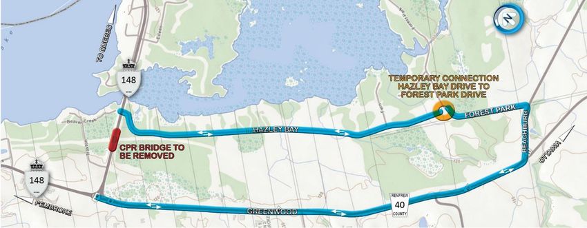
Freedom of Information and Protection of Privacy

Information through this Online Public Information Centre is being
collected in accordance with the Freedom of Information and
Protection of Privacy Act (R.S.O. 1990). This information will be kept
on file and may be included in study documentation. With the
exception of personal information, all comments will become part of
the public record. Names and addresses will be kept confidential.
If you have any accessibility requirements in order to participate in this
project, please contact one of the Project Team members listed at the
end of this presentation.
You are encouraged to contact the Project Team if you have any
questions or concerns regarding the above information.
                                                                             3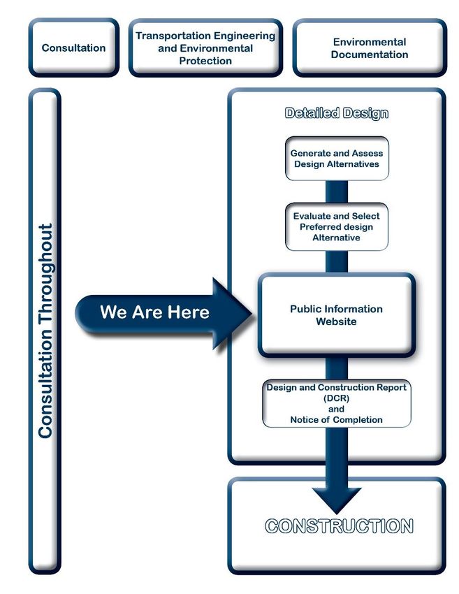
Project Overview
Rehabilitation of Highway 148 from Greenwood Road to the
Quebec Border
Removal of the existing CPR Overhead Bridge and replacement
with a new trail culvert
To facilitate the removal of the structure, the Highway will be
closed and traffic detoured via local roads for 3 weeks
4Purpose
The purpose of the Online Public Information Centre (PIC) is to:
Provide Background on the Study
Present the Study Process
Describe Existing Environmental Conditions
Outline Proposed Improvements including:
Proposed Work
Construction Staging
Detour Details
Environmental Impacts and Mitigation Measures
Obtain Public Input
Present Next Steps
5Environmental Assessment Process
Group ‘B’ undertaking under the Class
Environmental Assessment for Provincial
Transportation Facilities (2000)
Opportunity for public input provided
throughout process
Public Notice published in Pembroke
Observer and sent to various agencies and
stakeholders
Design and Construction Report (DCR) will
be prepared for a 30-day public review period
and will document the study process, public
consultation and potential environmental
impacts and mitigation; a DCR typically
documents Detail Design, which is the
development of the transportation plan to the
design implementation level of detail
Comments received will become part of the
public record
6Study Background
Preliminary Design and Environmental Assessment (EA) Study
was completed and documented in a Transportation
Environmental Study Report (TESR) which was approved in
February 2018 Class EA Process
Preliminary Design and EA study assessed and evaluated
existing and future highway needs, including operational and
safety improvements, pavement rehabilitation and active
transportation
Preliminary Design also determined most appropriate strategy
for the removal of the Canadian Pacific Railway (CPR) bridge
over the former rail line crossing of Highway 148
7Study Background (continued)
The Preliminary Design and Environmental Assessment Study
recommended the following:
Replacement of the CPR Bridge with a recreational trail culvert
Paved shoulders, 2.5 m wide to accommodate cyclists and to improve
connections to paved shoulders of the Des Allumettes Bridge project
New right-turn lane at Hazley Bay Drive
Protect for a 1.0 m painted buffer in the shoulder for potential future
cycling route designation
Detour traffic for 3 weeks along Hazley Bay Drive, Forest Park Road,
Beachburg Road and Greenwood Road
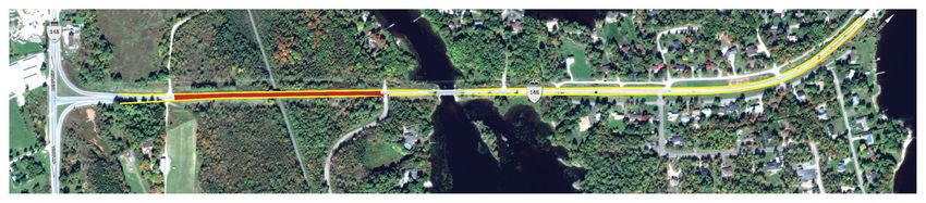
8Proposed Highway Improvements
2.5 m paved shoulders along Highway 148 (yellow)
New right-turn lane at Hazley Bay Drive
Drainage improvements
Removal of the existing CPR overhead structure and replacement with a
culvert (next slide)
Lowering the road profile by approximately 1 m in the vicinity of the CPR
overhead structure to improve sight distance (area is marked in red)
9Proposed Detour Improvements
Pavement rehabilitation upgrades to Hazley Bay Drive to accommodate traffic and a
new temporary connection between Hazley Bay Drive and Forest Park Road
Improved turning radii to the intersection of Forest Park Road and Beachburg Road
The project team is working with the Township of Laurentian Valley to determine the
method of closure for the connection between Hazley Bay Drive and Forest Park
Drive. Recommendation from Preliminary Design was to install a gate and maintain
access for pedestrians and cyclists
10Construction Staging
Construction tentatively scheduled to commence Fall 2018 and
completed in 2019, subject to change based on funding, design,
environmental approval, property acquisition and construction
requirements.
Pavement Rehabilitation on Highway 148 to be carried out
using single lane closures controlled by flagging
Closure of Highway 148 at the CPR structure is required to
facilitate CPR overhead structure removal and replacement;
closure will occur over a period of no more than 3 weeks and
traffic will be diverted along the detour route
11Construction Staging (Continued)
Anticipated and subject to award timing and contractor schedule:
Site preparation and start construction on new trail culvert at
CPR (2018)
Construct detour (i.e. Pavement rehabilitation upgrades and
drainage improvements to Hazley Bay Drive; temporary
connection between Hazley Bay Drive and Forest Park Road;
and improvements to the intersection of Forest Park Road and
Beachburg Road [Between July 15 and September 30, 2019])
Complete bridge removal/replacement and profile change under
full closure using detour (3 week window in late summer / early
fall 2019)
Complete pavement rehabilitation on Highway 148 (fall 2019)
12Existing Environmental Conditions
Fish and Fish Habitat
Field investigations conducted summer 2017
8 of 13 culvert locations identified as providing direct fish habitat
(i.e. fish captured at culvert)
Culverts along Highway 148 and Hazley Bay Drive feed into
Hazley Bay
Culverts assessed along Forest Park Road drain into the Lower
Allumette Lake
Ministry of Natural Resources and Forestry (MNRF) classify
each tributary as coldwater thermal regimes with mixed fish
communities
13Existing Environmental Conditions (Continued)
Terrestrial Ecosystems
Located within former glacial Ottawa River and Champlain Sea
within the Petawawa Sand Plain and Ottawa Valley Clay Plains
Laurentian Valley Official Plan indicates lands North and South
of Highway 148 include Provincially Significant Wetland (PSW)
Area supports variety of wildlife, vegetation communities (21),
environmentally sensitive areas (7 wetland communities) and
provides habitat for some Species at Risk (SAR)
14Existing Environmental Conditions (Continued)
Socio-Economic
Rural and low density residential (approximately 144 properties)
Emergency vehicles use Highway 148 as an emergency access
corridor
School buses and cyclists use Highway 148 as a transportation
route
A number of utilities including natural gas and hydro exist along
Highway 148
15Existing Environmental Conditions (Continued)
Archaeology – Stage I / Stage II
Hazley Bay Drive detour and two trail options determined to
have potential due to proximity to water therefore Stage II
assessment was conducted
Stage II assessment did not recover any archaeological
remains
Cultural Heritage
Hazley Bay Drive stone culvert crossing was determined to
retain cultural heritage value and can be considered for
municipal designation
16Environmental Impacts and Mitigation Measures
Fish and Fish Habitat
In-water works or work on channel banks only permitted
between July 16 to September 30
Develop and implement Erosion and Sediment Control Plan
Bank re-vegetation and stabilization
Machine operation constraints
17Environmental Impacts and Mitigation Measures
Terrestrial Ecosystems
Appropriate protection along the perimeter of designated work
areas as required to limit construction impacts
Awareness training provided to all on-site personnel
Protective measures prior to turtle nesting season (June –
September) in order to exclude turtles from the site and to
prevent nesting in areas which may be disturbed by digging or
other works
Develop Revegetation and Replanting Plan
Avoid clearing during migratory bird timing window (April 15 –
August 31) otherwise screening for breeding birds must be
conducted by an Avian biologist
18Environmental Impacts and Mitigation Measures (Continued)
Noise
Ministry will apply for a Noise By-Law Exemption for the 3 week
closure period.
Construction noise will be temporary and largely unavoidable
The Contractor will be required to keep equipment in proper
working order and idling to a minimum
19Environmental Impacts and Mitigation Measures (Continued)
Socio-Economic
The traffic detour is anticipated to be in place for approximately 3
weeks
Construction activities will be scheduled in a manner to minimize
impact to the community
Emergency Medical Services / Fire will be notified of the
construction, highway closures and detours
Advance notification signage to notify motorists of the Highway 148
closure will be provided two weeks in advance of the closure
MTO is working with Ministère des Transports, de la Mobilité durable
et de l'Électrification des transports to provide alternative route
signage in both Ontario and Quebec
OPP will assist with the Highway closure and speed control when
necessary
20Environmental Impacts and Mitigation Measures (Continued)
Cultural Heritage
Potential impact to the Hazley Bay Drive stone culvert will be
mitigated by installation of protection measures such as steel
plates on the wearing surface above the culvert
Staging and construction activities to avoid impacts to the
identified cultural heritage resource
21Next Steps
Following the Online PIC, the Project Team will:
Review and respond to public comments
Seek Council Resolution will be sought
Finalize the detail design and construction staging plans
Prepare a Design and Construction Report (DCR)
DCR will be placed on the public record for a 30-day review,
where members of the public can review and comment on the
study
Issue Environmental Clearance for Construction Start
22Thank you
Your input is important to us.
Please feel free to ask questions and submit your comments by
May 3, 2018 to the Project Team members listed below:
Chris Belanger, Project Manager Brad Hewton, P.Eng., Consultant Project Manager
Ministry of Transportation – Eastern Region Morrison Hershfield Limited
1355 John Counter Blvd., P.O. Box 4000 2440 Don Reid Drive
Kingston, ON K7L 5A3 Ottawa, ON K1H 1E1
tel: 613-540-5187 or 1-800-267-0295 tel: 613-739-2910, ext. 1022292 or 1-877-644-7687
fax: 613-540-5106 fax: 613-739-4926
e-mail: chris.belanger@ontario.ca e-mail: bhewton@morrisonhershfeld.com
23You can also read