IJC Lake Champlain - Richelieu River Flood Study Presentation to the VTCAC - Mae Kate Campbell, US Study Manager - Lake ...
←
→
Page content transcription
If your browser does not render page correctly, please read the page content below
IJC Lake Champlain – Richelieu River Flood Study

                                                               Presentation to the VTCAC

                                                               Mae Kate Campbell, US Study
                                                               Manager
Fisk Point – Isle La Motte, VT; Lake Champlain Basin Program

                                                                                             2021-05-12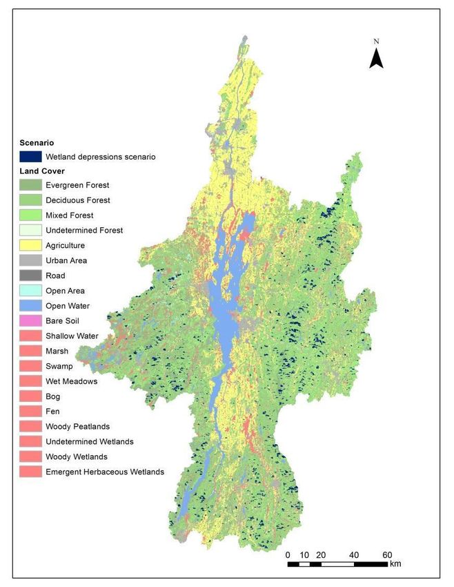
The IJC commissioned this study, which
has several areas of focus

 • Causes and impacts of past floods

 • Floodplain best management practices

 • Flood adaptation strategies

 • Advance binational flood forecasting

 • Potential flood management and mitigation measures

 • Social and political perception to measures
                           2                            2021-05-12
LCRR Basin Overview

▪ 23,899 km2 (9,227 mi2)
  ▪ 84% in the United States
  ▪ 16% in Canada
▪ The Saint-Jean Shoal (red star) is the hydraulic control
 for Lake Champlain and the upper Richelieu River and
 determines water levels upstream.
▪ The Chambly Canal (purple circle)

                                            3                2021-05-12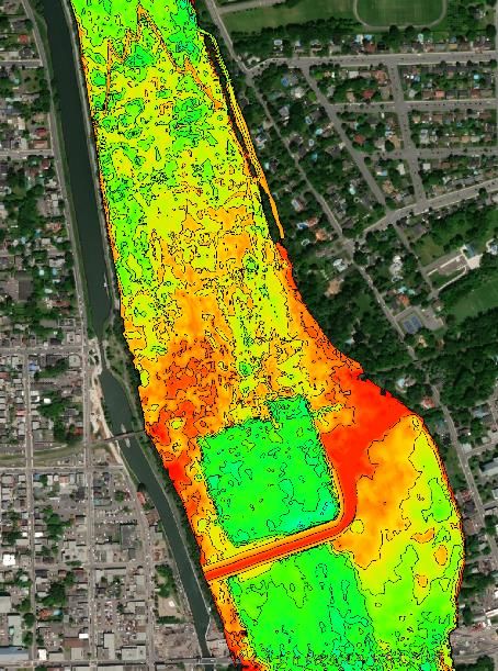
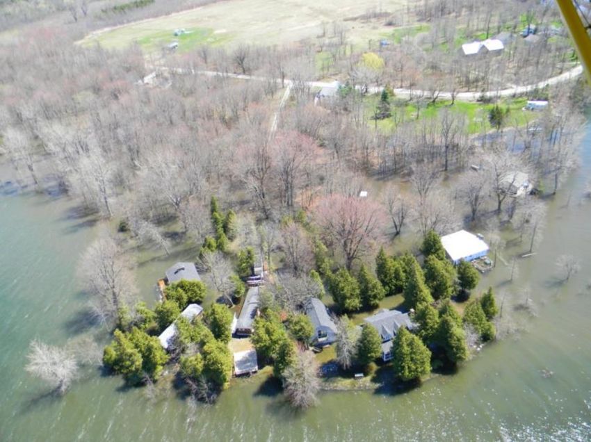
Flooding is an ongoing issue in the basin

                         4                    2021-05-12
Vertical datum: NAVD88
Study explores a range of flood mitigation solutions
                to reduce flood levels and build resiliency

• Goal 1: Reduce high water levels and limit flooding impacts
    •   Reduce river levels with structural solutions
    •   Impede water inflows to the lake by enhancing wetlands or storing water
• Goal 2: Reduce flooding vulnerability and build flood resiliency
    •   Enhance flood response capabilities
    •   Improve floodplain management

•   Final recommendations will include results from all four areas of focus

                                                                                  2021-05-12

                                                     6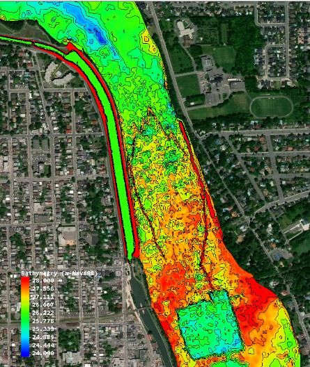
The impacts of mitigation measures will
       be evaluated using the ISEE system

• ISEE includes:                                   Integrated Social – Economic – Environmental
  • several spatio-temporal databases
  • water level time series and Performance
     Indicators simulated with computer models
• As water level peaks are reduced or
  vulnerable properties protected by mitigation
  measures, flood damages in affected grid
  points change
• Impacts can be presented by sector and/or
  regions (upstream, downstream) for a specific
  event or over a time series

                                              14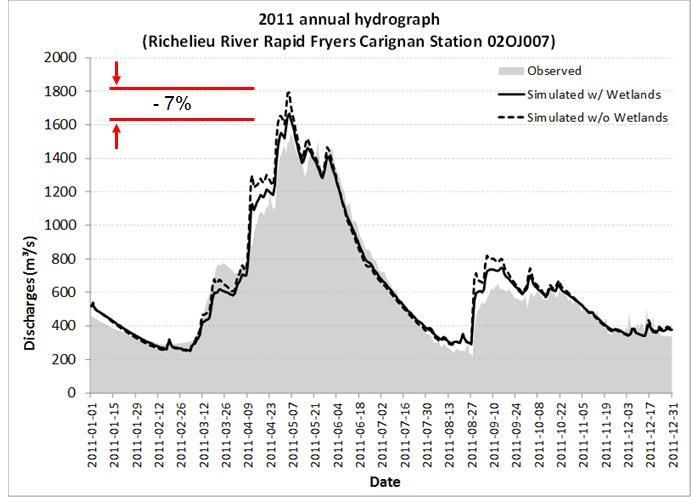
Study Board will consider seven criteria to
assess proposed mitigation measures
Criteria
1. Within study scope and mandate 5. Equitable and fair
2. Implementable 6. Environmental considerations
3. Technically viable 7. Robustness to climate change
4. Economically viable
Social and political acceptability will be an important consideration.
7 2021-05-12
Looking at vulnerability to climate from
four approaches
                     Four perspectives examined to
                     determine future water supplies
                     1. Stochastic models
                     2. Climate models feeding a hydrological
                        model
                     3. Stress test using different combinations
                        of temperature and precipitation to
                        power a hydrological model
                     4. Probable maximum flood (PMF) uses
                        possible combinations of 3 variables:
                        snow stock, temperature changes and
                        precipitations
                     Results expected in the summer of
                     2021!
                 8                                  Wednesday, May 12, 2021
Climate Variability and Change Impact on
             Water Supplies

 • Study suggests Lake Champlain and Richelieu River water levels may
   generally decline because of climate change.

 • But the research also points to the plausibility of greater than 2011 floods.

 • The Board links climate research to decisions, asking, what should we do if
   climate variability and change might affect water levels in different ways.

                                        9                                      Wednesday, May 12, 2021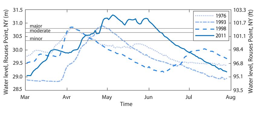
Human activity has affected water flow and
       levels

•   Eel traps (1850)
•   Submerged dykes for old mills (1860)
•   Man-made islands, Iberville (1800)                 Eel traps
•   Bridges and bridge piers
                                               Canal    Man-made
•   Chambly Canal widening, early 1970s                  island
•   Homes built in the floodplain
                                                       Old
                                                       submerged
                                                       dykes

                                           8                       2021-05-12
To reduce water levels, six possible structural
alternatives have been investigated
1. Remove human-placed artifacts at Saint-Jean shoal to
remove obsolete man-made structures
2. Divert water through the Chambly Canal during floods
3. Combine parts of 1 and 2
4. Install a fixed submerged weir 11 km (6.8 miles) upstream
from Saint-Jean-sur-Richelieu
5. Install an inflatable weir at the same upstream location
6. Install an inflatable weir at Saint-Jean Shoal
9 2021-05-12To reduce water levels, six possible structural
alternatives have been investigated
• Study Board requested further analyses be focused on:
• Using the Chambly Canal to route additional flow,
• Modifications to Saint-Jean-sur-Richelieu Shoal to increase the river’s
conveyance.
• Three additional alternatives were developed and being assessed:
• Alternative 1: Removal of human artifacts on the shoal and construction of a
crump weir,
• Alternative 2: Optimized Chambly Canal diversion (not cost-effective),
• Alternative 3: Alternative1 with modest Chambly Canal diversion.
9 2021-05-12Promising Theme 1 Structural Solutions
Diversion Exit
Alternative 1 Alternative 3
Canal
Gate
Selective removal of shoal
and submerged dikes
Diversion
Entrance
Reshaping
Crump Weir
Crump Weir
ILCRR Meeting with Quebec Ministries 13 Wednesday, May 12, 2021Preliminary Results for Promising
Alternatives
• For an event like 2011
• Flow → 1477 m3/s
Alternative 1: Selective Removal of Artifacts and Crump Weir (Cost - $8 M)
• At Saint-Jean-sur-Richelieu Marina → Relief of 15.0 cm
• At Lake Champlain → Relief of 10.4 cm
• Preliminary Benefit-Cost Ratio → ≈3.0
• Alternative 3: Alternative 1 with Modest Chambly Canal Diversion (Cost - $21 M)
• Flow through diversion → 80 m3/s
• At Saint-Jean-sur-Richelieu Marina → Relief of 19.2 cm
• At Lake Champlain → Relief of 12.4 cm
• Preliminary Benefit-Cost Ratio → ≈1.2
• For low flow events like 1964 (for both options)
• Flow → 59 m3/s
• Lake Champlain water levels → Raises by 10 to 34 cm
14 Wednesday, May 12, 2021Upland Storage
15 Wednesday, May 12, 2021Enhancing wetlands in upland locations is unlikely
to reduce Lake or Richelieu River flooding
• Existing wetlands, particularly on the US side, have helped
to provide some flood relief on the 2011 peak flood on the
Lake and Richelieu River and relief at local tributary levels.
• Analyses done by the Study determined that an area three
quarters the size of Lake Champlain would be required for
upland storage to produce a comparable flood relief as
proposed for the Alternative 1 structural solutions.
• A preliminary Benefit-Cost Ratio ( < 0.01) suggests that
this is not a cost- effective mitigative measure for basin-
level flood relief.
16 Wednesday, May 12, 2021Study’s Model/Database Development
• It is recognized that upland storage can provide many
benefits: such as reducing tributary flooding and local
impacts; improving water quality through trapping
nutrients and other contaminants; and providing
essential aquatic habitat.
• A high-resolution tool and databases (developed by
INRS-ETE) covering the complete LCRR basin can be
used to determine targeted upland storage projects.
17 Wednesday, May 12, 2021Improving flood prediction and emergency
preparedness capabilities
• Will make recommendations to implement an
operational, real-time forecasting and flood inundation
mapping system
• Surveyed the public regarding risks
• Analyzing hazard mitigation plans
• Researching early warning systems
• Conducted targeted interviews with US emergency
responders and planners in Vermont and New York
16 2021-05-12Social acceptability and political feasibility of flood
mitigation measures were assessed in the US
• More concerns expressed about tributary flooding than lakeshore flooding
• Political entities desire improved flood predication capabilities and
communications
• Public risk perceptions are correlated with flooding experience
• However, most households had taken no action to reduce risk even if high
flooding risk perceived
• TV, radio and word of mouth via neighbors are primary sources of flood hazard
information for residents
• Hazard Mitigation Plan analysis: lakeshore flooding not a concern at any level of
gov't; focus of plans is on maintenance of infrastructure (e.g., roads, bridges)
19 2021-05-12Flood Forecasting and Inundation
Mapping System
• The Study is incorporating wind, wave, and ice observations to
improve forecasting on Lake Champlain.
• An experimental 5-day water level forecast has been developed.
• An experimental 30-day forecast is under development.
• A flood mapping component is being explored.
ILCRR Meeting with Quebec Ministries 20 Wednesday, May 12, 2021Theme 4: Floodplain Management
The following four White Papers are at various stages of completion:
1. Flood risk mapping (Ouranos lead).
2. Better communication of flood risks (U. of Waterloo - Dr. Dan Henstra).
3. Floodplain occupancy management (Ouranos lead)
4. Development of flood insurance programs (U.S. National Academies of Science - Dr.
Len Shabman)
The Study is researching best management practices for these four different, but
interrelated topics of floodplain management.
The knowledge gained from this work will be applied to the LCRR basin setting and used
to provide different perspectives to the governments on potential best floodplain
management practices.
21 Wednesday, May 12, 2021Timeline through the end of the Study
Integrated Social,
Integrative Social, Political,
Environmental, and
and Economic Considerations
Economic model
A Strategy for Addressing US and Canadian Flood
Climate Uncertainty Water Supply forecasting: Institutions, Final recommendations to
Affecting LCRR Flooding Scenarios products, services IJC
May June July Aug. Sept. Oct. Nov. Dec. Jan. Feb. March
Potential Structural White papers: Risk Public stakeholder meetings
Flood Mitigation communication, insurance
Measures programming, flood risk
mapping, floodplain land use Performance indicators
Addendum on Shoal
Watershed Storage Restoration and
22 Chambly Wednesday, May 12, 2021
Canal DiversionThank you!
• Stay up to date with progress of
the LCRR Study at:
www.ijc.org/lcrr
25You can also read