KARANTINA URBAN SNAPSHOT - MARCH 2021 - ReliefWeb
←
→
Page content transcription
If your browser does not render page correctly, please read the page content below
KARANTINA
URBAN
SNAPSHOT
MARCH 2021

Developed by Beirut Urban Lab
In partnership with ACTED
Funded by UNHCR

TABLE OF CONTENTS

  TABLE OF CONTENTS .......................................................................................................... 2
  INTRODUCTION ................................................................................................................... 3
  METHODOLOGY .................................................................................................................... 4
  I.    NEIGHBORHOOD CHARACTERISTICS ........................................................................... 7
  II.   STAKEHOLDERS IN THE NEIGHBORHOODS ............................................................... 21
  III. RECOVERY STATUS .................................................................................................... 23
  IV. RECOMMENDATIONS OF SITES FOR POTENTIAL COMMUNITY-BASED PROJECTS .. 25
  V.    ANNEX A ..................................................................................................................... 30

2 | KARANTINA URBAN SNAPSHOT | Working document
INTRODUCTION
_______

On August 4th, 2020, the Port area of Beirut was rocked by two massive explosions, killing over
                                           1
200 people and wounding more than 6,000 . Buildings were destroyed or damaged within a 10 km
area around the port, including an estimated 70,000 apartments and nearly 40,000 residential or
commercial spaces.
UNHCR partnered with four international organizations (MEDAIR, ACTED, Save the Children, and
Intersos) to rehabilitate shelters, restore shared spaces, and introduce the upgrading of selected
neighborhood–level communal spaces, in six neighborhoods severely affected by the blast:
Karantina, Mar Mikhael, Geitawi, Badawi, Bachoura, and Karm el-Zeitoun. In this framework, ACTED
and Beirut Urban Lab at the Maroun Semaan Faculty of Engineering and Architecture (MSFEA) at
the American University of Beirut (AUB), partnered to develop an assessment meant to support the
effort of locating the recovery efforts within an urban-scale approach in each of the above-
mentioned neighborhoods.
This report is one of the six Urban Snapshots conceived by the Beirut Urban Lab (BUL) in
partnership with ACTED and funded by UNHCR in Fall/Winter 2020-2021.
The reports are designed to a) Inform the understanding of each of the four INGOs and UNHCR
about the urban processes underway in each of the neighborhood prior to the blast, focusing on
those processes that are likely to slow-down or threaten the return of residents and the recovery of
the neighborhood, and b) Whenever possible, point the INGOs in each of the neighborhood towards
potential communal projects of important social relevance.
Further, the Urban Snapshots have the potential to support the work of the community of social
workers, city planners, urban designers, researchers, activists, and others who are intervening with
relief, repair, and recovery in short, medium, or long term development in Beirut in response to the
August 4th, 2020 port blast.
The assessment built on the knowledge and research of the Beirut Urban Lab about each of the six
neighborhood’s history and urban conditions. Additional fieldwork was conducted by a team of field
researchers to gather the needed information from neighborhood-level interviews and discussions
with residents, NGOs, etc.
Each of the reports locates the effects of the explosion within the larger urban trends that have
influenced the studied neighborhood over the past three decades. It does so by providing a
preliminary urban documentation and analysis of the neighborhood conditions, including a brief
historical overview, insights about contextual urban trends, profiles of influential stakeholders, and
a brief review of socio-spatial conditions. To the extent possible, the reports thus cover both urban
trends and recovery efforts at the household (e.g., resident, business-owner), building, and
neighborhood scales (e.g., shared space, road, recycling).
Each report further unravels some of the critical threats that are likely to undermine the recovery
of each neighborhood, including dwellers’ return, the rehabilitation of shared spaces and amenities,
the reignition of economic activities, and the restoration of tangible and intangible heritage.
The reports are not conceived as exhaustive surveys. Rather, they are snapshots, taken at a specific
moment (i.e. November-December 2020), yet located within a solid understanding of the economic,
social, and political forces that influence Beirut’s ongoing urbanization. Indeed, they build, as
outlined thoroughly in the methodological section, on pre-existing knowledge of the neighborhood
developed at the BUL and complemented by data gathered during November and December 2020
directly in the neighborhoods.

1
    Lebanon Reform, Recovery and Reconstruction Framework 3RF

3 | KARANTINA URBAN SNAPSHOT | Working document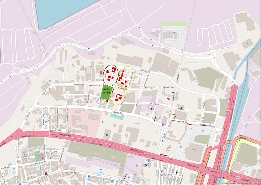
METHODOLOGY
_______

The selection of neighborhoods and the delineation of their boundaries were proposed by UNHCR,
reflecting its areas of intervention. In order to improve the coherence of the study and its
recommendations, the BUL research team introduced mild modifications in delineating
neighborhoods to account for the internal characteristics of the neighborhood, particularly lot
morphologies, building typologies, and population profiles. Neighborhood boundaries do not
coincide to official administrative boundaries.

The reports are the result of the work of six field researchers, one reporting officer and one
research team coordinator hired by ACTED who were trained by the Beirut Urban Lab (BUL) team
and worked under its supervision from October to December 2020. The positions were filled
through a transparent and competitive process putting the emphasis on previous experience and
methodological trainings; three of the six fieldworkers had worked for the Beirut Urban Lab before,
and another was a recent graduate of the Master in Urban Design program at AUB.

The production of this report relied on case-study research methods of data collection as defined
       2
by Yin. In essence, Yin sees the goal of case studies as understanding complex social phenomena,
relating data to propositions and aiming at analytical generalization as if they were an experiment.
By nature, case-study research is qualitative as it seeks to provide in-depth evidence in lieu of
quantitative data. Case-study research typically uses multiple methods to collect different kinds of
evidence (e.g. documents and archival records; interviews; direct and participant observation;
physical artifacts; surveys), as this insures the triangulation and cross-checking of evidence, and
hence more rigorous and valid data analysis.

For this report, BUL relied on five data sources collected through: (i) desk reviews of available
publications, technical reports, records and other documents; (ii) field observations (direct and
participant) using the guide available as annex C; (iii) qualitative semi-structured interviews with
key informants (e.g. mukhtar(a), NGOs’ representatives) according to protocols described below
and available as annex D, as well as informal conversations with residents and business-owners; (iv)
data from the shelter technical assessment collected by INGOs intervening in the area and provided
by UNHCR in December 2020; (v) surveys and maps compiled by the BUL’s researchers about
Beirut’s built environment in the context of the Beirut Built Environment Database (BBED)3.

(i) Documents and Records (Desk review)
                                                          4
Data analysis relies on the review of several gray reports , academic research, and references
available about the neighborhood. They are listed as footnotes throughout each report whenever
they were used as evidence for the documentation and analysis of some of the neighborhood’s
urban trends.

(ii) Field Observations
The researcher conducted fieldwork for about 12 full days in the neighborhood (1.5 day per week for
a duration of 8 weeks, on the average), observing directly the built environment, documenting
damaged constructions and processes of physical repair in residences and businesses, as well as
noting the following: shops’ activity/closure; buildings’ quality and condition; abandoned/dilapidated
buildings; clusters of impoverishment; construction activity; heritage buildings; the use of
open/public spaces by the community and presence of greenery; infrastructure conditions (access
to water and electricity, traffic congestion, conditions of streets, sidewalks and stairs); options for

2
    See Yin R.K, Case-Study Research: Design and Methods (2014) London: Sage.
3
  The Beirut Built Environment database is an online GIS platform developed by the Beirut Urban Lab at the
American University of Beirut. The initiative brings together a collection of maps, documents, and surveyed
indicators about actors as well as spatial and environmental characteristics that can inform ongoing research,
public policy making, and advocacy about the city. It also relies on a database of building permits dating back
to 1996.
4
 Gray literature is produced outside of the traditional commercial or academic publishing and distribution
channels and typically includes reports, working papers, government documents, white papers and evaluations.
Organizations that produce grey literature include government departments and agencies, civil society or non-
governmental organizations, academic centres and departments, and private companies and consultants.

4 | KARANTINA URBAN SNAPSHOT | Working document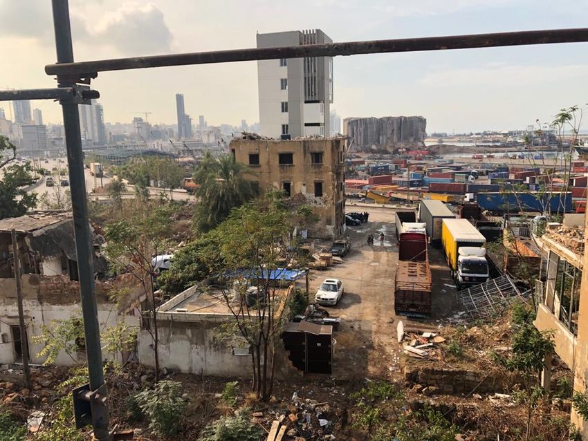
waste disposal. The researcher also observed social interactions in the neighborhood, when they
occurred and documented them, including groups of migrant workers and refugees. They were
tasked to also document key landmarks in the neighborhood (educational, religious, cultural,
corporate), and to report visible political sites and signs (flags, icons, posters, markings on walls).
These observations were recorded as field notes and mapped, when relevant, serving as evidence
that substantiates several claims made in this report, as indicated in the text.

(iii) Qualitative semi-structured Interviews and Conversations with key informants
Field researchers were trained to conduct semi-structured qualitative interviews with key actors in
the neighborhood they were able to reach out to amidst the difficult working conditions posed by
the COVID-19 pandemic. In each of the neighborhoods, researchers interviewed elected local
representative (mukhtar(a)), NGOs’ representatives, as well as dwellers and business-owners who
stayed and are engaged in the repair process. The interviews’ questions were organized in three
broad categories: (a) Awareness about the actors in charge of repair (do they know who is in
charge, who visited them, who returned, what support were they provided with thus far); (b)
Respondent’s tenure status (do they own or do they rent, do they pay in real or Lebanese dollars or
in LBP, how precarious is their tenure situation, do they get any support from family abroad, what
are their future plans: are they staying or leaving, and why?); (c) Processes of repair (did they
receive support, for what, from who, where is the process at, what is still to be done, are damaged
common spaces fixed?). In addition to formal interviews, researchers also held informal
conversations with residents and business-owners, on selected sections of the interview guide.

All interviews and conversations were conducted after securing verbal consent and according to
ethical standards of social research. Cited interviews and conversations have been anonymized and
personal identifiers removed to protect interlocutors.
Field observations and qualitative interviews were documented by field researchers through
pictures and detailed notes, geo-referencing the location wherever possible. They then reported the
interviews and developed fact sheets that were discussed with the rest of the team.

(iv) Quantitative Technical Assessment Data collected by INGOs operating in the area under
UNHCR funding
Qualitative findings are complemented by an analysis of technical assessment data shared by
UNHCR, providing technical assessment of a prioritized number of damaged houses in the six
neighborhoods (according to criteria set by UNHCR), conducted in Fall/Winter 2020 by its INGO
implementing partners (one per neighborhood). BUL researchers analyzed this dataset and
extracted statistical information from it, which is referred to in the other six reports. It should be
noted that the technical assessments were conducted in specific targeted areas of each neighbored
as part of the shelter response implementation, therefore not resorting to any type of probability
sampling. Furthermore, the data used as part of this research originates from UNHCR partners only,
thereby not taking into account any other technical assessment data that may potentially have
been collected by other actors in the area. As such, corresponding findings may not be extrapolated
to the entire neighborhood, but rather interpreted as a useful triangulation source for the findings
deriving from qualitative data sources. The total number of surveyed units in the 6 neighborhoods
amount to 5316, including only 3 in Karantina. Given the very small number of assessments led in
Karantina, quantitative data was deemed not statistically representative nor informative, and thus
not used in the present report.

(v) Spatial Data and Mapping
The report relies largely on spatial data compiled within the framework of the BUL’s Beirut Built
Environment Database (BBED), which has been made available thanks to the MoU agreed upon
between ACTED and BUL. This includes data regarding: population size; density; damage
assessment; building age; building height; real-estate developers’ profiles; vacancy rates; number of
loans acquired from the Public Corporation for Housing (PCH); open public spaces and unbuildable
lots. Data listed in the BBED is based on official records of filed building permits at the Lebanese
Order of Engineers and Architects, official property records from the Land Registry, comprehensive
field surveys, and registration records. This information is reported within the text itself, in related
sections, as well as in maps compiled in Annex A. It is used as a main source of evidence in the
“Urbanization Trends,” “Socio-Demographic Profile,” “Housing Conditions,” and “Quality of Public
Spaces” sections of the report.

Readers should acknowledge the fact that the Urban Snapshots were not designed following a
Neighborhood Profile approach, which would have required more time and resources. The Urban
Snapshots were developed in the aftermath of the Beirut explosions, during the Fall/winter 2020-

5 | KARANTINA URBAN SNAPSHOT | Working document

2021. BUL relied on the most relevant and up-to-date available data from the sources listed above,
while more generally coordinating with the Forward Emergency Room (FER). Figures that relate to
emergency response actors’ achievements reflect information as collected during the research
period. As such, they are not meant to provide an up-to-date nor comprehensive overview of all
achievements as of end of December 2020.No systematic and comprehensive surveys of damaged
housing and business units were made available, with detailed datasets regarding associated
tenure, socio-economic, infrastructure and other variables, which would have allowed us to derive
more precise patterns and urban trends associated to the Blast.
The health situation in the country also constrained BUL from conducting a larger number of
interviews with dwellers, business-owners, and stakeholders to profile in more depth and with more
rigor the modalities of repair in the neighborhood, the governance of actors, and inscribe
recommendations for community-based projects in a sound analysis of power groups and
opportunities and challenges for intervention. Yet, BUL believes this report successfully point
towards potential communal projects of important social relevance, paves the way for this work to
be further developed out by actors working on the Port Blast recovery, and presents productive
avenues for future research projects and community-level initiatives.

What is Unique about Karantina?

This report covers the neighborhood of Karantina. Of the six neighborhoods included in this project
(Map 1), Karantina stands out as being “outside” the city. Indeed, the neighborhood’s historical
location as the city’s quarantine, a position exacerbated over the years by the development of the
main Beirut-Tripoli highway that separated the neighborhood from the rest of Beirut, placed it in a
permanent state of exception. This state of exception is rendered acute by the legacy of the civil
war and the continued militarization of the neighborhood. Due to the close proximity of Karantina
to the blast’s epicenter and the deteriorated physical conditions of its residential fabric, the area
suffered severe damage. Repair is also slow in areas where structural damage was induced since
NGOs have been unable to address this category of damage.

Fieldwork for Karantina was conducted as part of the larger team of the Beirut Urban Lab that has
established a bottom-up research unit in the neighborhood in partnership with UNDP. Field
Researcher Abir Cheaitli joined the team to collect information needed for this report and bridge
between the ACTED-UNHCR team and the BUL-UNDP teams. It is noteworthy that the structure of
this report defers a little from the other five reports due to the choice that was made to participate
with the team on the ground from BUL for the study.

6 | KARANTINA URBAN SNAPSHOT | Working document
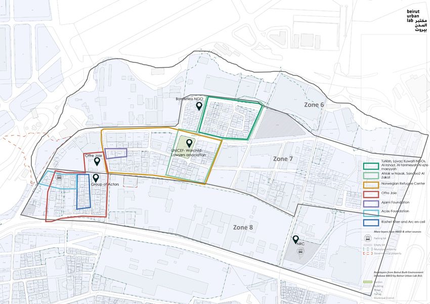
I.       NEIGHBORHOOD CHARACTERISTICS
     _______

     1. Area of study
 A.       Geographic context/ area of the study

     Neighborhood Definition

     For this study, BUL defined the
     neighborhood of Karantina as extending
     over the entire area of Municipal Beirut that
     falls North of the Charles Helou highway and
     east of the port, within the Medawar
     neighborhood. As such, the neighborhood is
     confined by hard borders that separate it
     from the rest of the city. These include
     natural edges (i.e., the Beirut River) and
     physical infrastructure (e.g., port, highway)
     (Map 2).                                           Figure 1. Refugee camp in Karantina in the early 20th
                                                        century. Source: George Granthan Bain Collection,
     One could assume that this entire area is          Library of Congress.
     one neighborhood. However, Karantina
     includes many overlapping zones, as will be
     described in the Land Use, Zoning, and
     Density section. It also holds heavy burdens
     that stand powerfully in the way of making
     this area a livable neighborhood, as will be
     described fully in the report. These include
     militarization, the close proximity to the
     port, large-scale infrastructure causing
     pollution, as well as the legacy of the
     Lebanese Civil War that made the area         Figure 2. Bakalian flour mill          Figure 3. Photograph by
     largely undesirable for residential functions opens in the 50s. Source:              Francoise Demulder
     and increased the attraction of large         www.bakalianmills.com.                 during the Karantina
     industries. As a result, rupture,                                                    eviction of Palestinian
     religious/political divisions, isolation, and                                        occupants (1976).
     severe disconnection from the rest of the                                            Source: Wikipedia.
     city are characteristics that describe this
     neighborhood; and recent processes of
     reconstruction and recovery exacerbated on those patterns.

     2. Historical Overview

     Historically, the neighborhood was the site of the city’s quarantine. Built in 1835-6 during the brief
     period of Egyptian rule by Mohamad Ali Pasha through his son Ibrahim Pasha, the quarantine would
     serve for decades as the site of isolation that protected the city from diseases brought by outsiders.
                             th
     At the turn of the 20 century, Karantina began to consistently house impoverished communities,
     beginning with Armenian refugees fleeing the massacres in Anatolia and extending eventually to
     include Kurdish refugees, Palestinian refugees, and poor rural migrants from Lebanon’s most
                                 5
     deprived neighborhoods. As such, population displacements have always had significant historical,
     political, social, and cultural effects on Karantina’s population. The neighborhood served eventually
     5
      See Kassir, S. 2003. Histoire de Beyrouth. Paris: Fayard, also Fawaz, M., & Peillen, I. (2003). The Case of
     Beirut, Lebanon. Understanding Slums: Case studies for the global report on human settlements. UN-HABITAT.
     London: University College London.

     7 | KARANTINA URBAN SNAPSHOT | Working document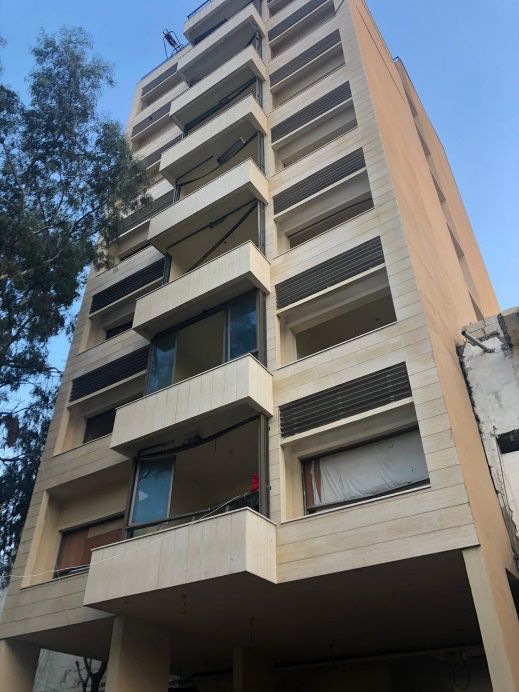
as a reservoir of cheap labor for the nearby port and industries, but also as a hotbed of mobilization
                                                      6
in the early years of the Lebanese Civil War in 1975.

Aside from the poverty of its dwellers and its consistently deficient infrastructure, the
neighborhood’s isolation was exacerbated by the passage of the Charles Helou highway in 1950,
which severed it from nearby Mar Mikhael, effectively shaping it physically as the backyard of the
city. As such, although the quarantine was closed at least a century ago, the neighborhood’s name
                                                                 7
continues to reflect, and rightfully so, its isolated condition.

In 1972, a study of the neighborhood estimated the population of Karantina at about 12,600 living in
                                                                               8
about 2,540 houses with an assumed average of 5.5 persons per household. At the time,
Lebanese nationals constituted 29.6% of the population while Syrian, Palestinian, Iraqi, and
                                2
Armenians constituted 70.6%. Shortly after, the neighborhood witnessed one of the worst
massacres and entirely changed the population of the neighborhood. In 1975, the Lebanese Civil
                                                                                           9
War was the site of notorious massacres that decimated much of its Muslim population. Since the
end of the Lebanese Civil War (1990), Karantina has gradually housed waves of poor families,
including Lebanese and Syrian families – many of whom were naturalized along electoral
                                                                                             10
calculations in the early 1990s, as well as migrant workers and Syrian refugees as of 2011.
Karantina is also the site of numerous public infrastructures, including the city’s (now-closed)
slaughterhouse, flour mills and the main headquarters of the waste management facilities. In the
few years before the blast, Karantina witnessed an influx of higher-end economic activities as well,
as will be outlined in the trends below.

3. Planning Parameters

Neighborhood Reading

Karantina includes several zones and functions. Field visits, interviews, and gray literature reviews
show complex land use patterns in the area (Map 8). These uses include residential (of multiple
national and religious denominations), industrial, recreational (e.g., bars, nightclub), cultural,
military, public (e.g., municipal parking areas, hospital) as well as an industrial zone and a cluster of
businesses.
Based on the history of settlements and political and religious alliances, the residential
neighborhoods of Karantina can roughly be described as two: al-Saydeh neighborhood (west) and
al-Khodor neighborhood (upper northeastern side). It is noteworthy that some of the poorest
residential settlements of the pre-civil war era have never been rebuilt.

The two residential neighborhoods differ considerably. Aerial photographs indicate that al-Saydeh
neighborhood was historically directly connected to Mar Mikhael, a reality confirmed by residents of
                     11
the neighborhoods. Named after al-Saydeh Church, the neighborhood maintains some of the
historical/religious and social allegiances with the area including its predominantly Christian
                                                                                                 12
population and an affiliation to the Lebanese Forces and Kataeb, two Lebanese Christian parties.

6
  Massabni, M (1977) ‘Contradictions Urbaines et Guerre Civile : La Destruction de la Quarantaine à Beyrouth’
In: International
Journal of Urban and Regional Research Vol 1, No 1, Edward Arnold Pp 132-144.
7
 It is noteworthy that there is no study of the impacts of the highway. It is however sufficient to look at aerial
photographs to assess it.
8
 Take, O. A. (1974). Urban dwelling environments: Beirut, Lebanon; case studies: Mkalles Housing Project
(24904091) [Doctoral dissertation, Massachusetts Institute of Technology]. http://hdl.handle.net/1721.1/78396.
9
     See Massabni, op. cit.
10
     See Fawaz and Peillen, op. cit.
11
     Aerial photographs from the personal collections of researchers in the Beirut Urban Lab.
12
  Information about the naming of the neighborhood was widely reported among its current residents and
confirmed by the existence of the church in the neighborhood. The two parties have offices in the
neighborhood.

8 | KARANTINA URBAN SNAPSHOT | Working document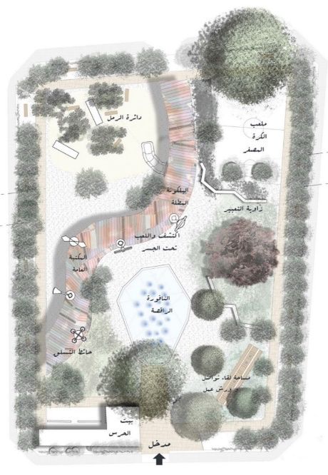
The passage of the highway severed the neighborhood and created a separate entity. However, the
urban fabric maintains a relatively similar quality of consolidated physical structures, residential
buildings, etc. Conversely, the al-Khodor neighborhood is a mixture of Lebanese and Syrian Sunni
         13
Muslims. In line with the other neighborhood, the cluster owes its name to al-Khodor mosque
nearby, on the other side of the highway, from which they were severed in the 1950s. It is
noteworthy that many of the Lebanese residents hold their citizenship thanks to a decree passed in
1994 with the help of the late PM Rafic Hariri. As such, they lean politically to the Future Movement,
                                                   14
the dominant Sunni political party in the country. However, given their historical nomadic
trajectory and their old settlement by the nearby slaughterhouse, they are often referred to as
“Arab al-Maslakh” (Arabs of the Slaughterhouse) – a term they consider derogatory.

Land Use, Zoning, and Density

A figure ground map (Map 3) revealed interesting information about the physical environment of
Karantina. The map shows that the physical built-up area in Karantina is approximately 30%.
                                                                                     2
According to data gathered from the BBED, Karantina has an area of 645,126 m , and holds 364
                                             2
buildings with a total footprint of 160,817 m . This is likely the lowest density in Beirut after
Downtown. The relationship between the built and unbuilt spaces, which imposes a low density, is
mainly due to the history of the area, the local zoning, land-use regulations, and the militarization of
the zone.

Furthermore, this scattered configuration is the result of Karantina’s complex historical patterns.
The Civil War brought Karantina’s informal settlements to the ground on January 18, 1976, leaving
most of its inhabitants displaced. Once the war was over, many residents came back. Some were
able to rebuild what was destroyed while others were surprised to find their land occupied by the
         15
military. Few interviewees mentioned that some residents were not able to obtain signed release
permits from landlords to rebuild.

4. Main Urbanization Trends Influencing the Neighborhood at the Time
   of the Blast

The analysis of the socio-spatial and socio-economic patterns of development revealed trends of
urbanization in the Karantina area. The aim of this analysis was to understand the urban fabric and
highlight current challenges that impact connectivity, inclusivity, and livability of its residents and
Karantina as whole neighborhood. These trends, in turn, should inform the approach of repair and
reconstruction.

4a. Militarization
                                                                                               16
Militarized security is a defining aspect of Beirut’s public and shared spaces. A 2010 study
conducted by Mona Fawaz, Mona Harb, and Ahmad Gharbieh shows that this security substantially
influences everyday life, reorganizes the city’s multiple publics, and enforces numerous forms of
restrictions on some of the city’s users, while facilitating the fluid circulation of others.

If Beirut is heavily militarized, Karantina presents an extreme case. Military security elements are
observed everywhere during fieldwork in Fall 2020: on the streets, sidewalks, and in open public
13
 Based on a full survey of the neighborhood conducted by the BUL-UNDP joint teams. For more, please see
www.beiruturbanlab.com
14
  Frangieh, G. (2016). Manufacturing Precarious Nationality in Lebanon: The Naturalization Decree of 1994, in:
The Legal Agenda, https://english.legal-agenda.com/manufacturing-precarious-nationality-in-lebanon-the-
naturalization-decree-of-1994/
15
  ARIJ. (2013, June 6). Karantina's Displaced: From Palaces to Basements.
https://en.arij.net/investigation/karantinas-displaced-from-palaces-to-basements/
16
  Fawaz, M., Harb, M., & Gharbieh, A. (2012). Living Beirut's security zones: An investigation of the modalities
and practice of urban security. City & Society, 24(2), 173-195.

9 | KARANTINA URBAN SNAPSHOT | Working document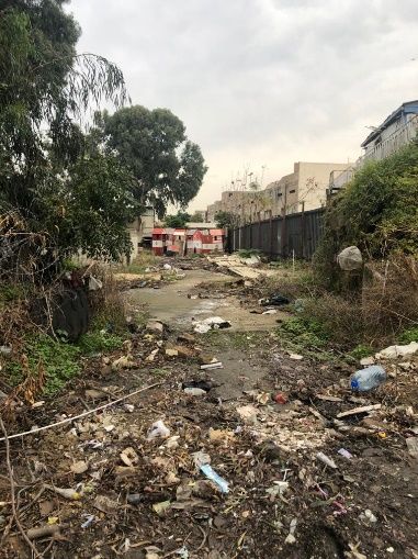
spaces. Many sidewalks and streets have been encroached on by physical security elements, such
as cement barriers, metal meshes, signs, and speed bumps. In many places, sidewalks and streets
are completely blocked and the flow of public circulation is interrupted. Some of these physical
elements seemed to be laid out haphazardly and forgotten.

The history of militarization of Karantina dates back to at least 1975 and the beginning of the
Lebanese Civil War. As noted above, the neighborhood was a site of intense fighting and was
identified by the powerful militia at the time as a site of threat and undesirable populations, the
                       17
area was bulldozed. Eventually, the Lebanese Army replaced the militias’ headquarters and
militarized the area completely. This militarization was further reinforced in the post-9/11 global
                                                                                                  18
militarization of port sites, when security around main infrastructures was globally enhanced. As a
result, to-date, four military bases are distributed at the peripheries of Karantina. During interviews
with residents, several claimed that one of the military bases, Site #2 shown in Map 8, was built on
                                                                                           19
private lots still claimed by their owners who had fled their homes during the Civil War.

Some of the residents interviewed about the heavy presence of the Army in the area showed
resentfulness. Among them, a few claimed that they were the owners of properties squatted by the
Army and currently live in Karantina in rental houses. They expressed strong frustration. They
mentioned that they would be able to address their current financial distress only if their properties
were returned to them so that they could sell them. Other resident-interviewees claimed that the
existence of military bases keeps the area safe from potential political threats.

4b. Increasing Diversity of Functions (Potential Gentrification)

Establishment of various industrial and cultural activities
along the eastern edge of the neighborhood were showing
their very early marks at the time of the blast, denounced
by a few journalists and researchers who noted the arrival
of artists, designers, and club owners, many of whom were
                                   20
attracted by the low rent market. Much of these activities
were commercial. Some saw these movements as part of a
positive trend since it brought a new wave of youth and
engagements of younger generations into the area. Yet,
the movement was also seen as a threat to existing locals
and their family businesses who saw this as potentially a
first wave of displacement and gentrification similar to
what has occurred in nearby neighborhoods such as
Gemmayzeh and Mar Mikhael.

Nevertheless, in recent times, the once known “isolated
Karantina” was revived by the overflow of locals with
distinct identities and specialties, introducing a new
dimension of land use and user groups. For example, high-
end venues opened in old warehouses and factories, such
as Forum de Beyrouth, followed by places like Flyp Urban              Figure 4. Encroachments of military
Park, Grand Factory, which was designed to “resemble an               security elements on public spaces
                                                                      (sidewalks and streets). Source: Abir
                                                                      Cheaitli, 2020.

17
  Battah, H. (2016, Jan 20). Remembering Karantina... who does? Beirut Report.
http://www.beirutreport.com/2016/01/remembering-karantina-who-does.html
See also Massabni, op. cit.
18
 For rising port security globally, see, for example, Faist, T. (2004) The migration-security nexus. International
migration and security before and after 9/11. Malmö University Electronic Publishing
19
  Researchers from the Beirut Urban Lab were able to verify the private ownership of the lot but not the
trajectory of the residents.
20
  Stoughton, I. (2019, May 09). The SoHo of Beirut: Why Karantina is now attracting designers, artists and DJs.
The National. https://www.thenationalnews.com/arts-culture/the-soho-of-beirut-why-karantina-is-now-
attracting-designers-artists-and-djs-1.858540

10 | KARANTINA URBAN SNAPSHOT | Working document
Distribution of building permits (1996-2018):
Karantina vs Municipal Beirut
8 200
7
6 150
Municipal Beirut
5
Karantina
4 100
3
2 50
1
0 0
Karantina Total in Beirut
Figure 5. Graph of building permits filed in Karantina and Municipal Beirut.
Source: Beirut Built Environment Database (BBED), Beirut Urban Lab, 2020.
abandoned factory being reclaimed by nature,” and Ballroom Blitz, housed in a former Harley
21
Davidson showroom. Artists were also attracted to the area and opened their own galleries and
ateliers, such as the SMO, Karen Chekerdjian, Art Factum, and Sfeir-Semler galleries (Map 8). These
trends had led a few researchers to suspect that some of the trends documented in nearby Mar
22
Mikhael could be repeated here.
Conversely, Karantina has not experienced the type of building development as in all other
neighborhoods of the city. As shown in the graph in figure 5, new residential permits and
developments have been consistently below the city’s average, keeping the influx of new residents
23
to a very low level.
21
Ibid.
22
For a review of property and gentrification in Mar Mikhael, see Fawaz, M., Krijnen, M., & El Samad, D. (2018).
A property framework for understanding gentrification: Ownership patterns and the transformations of Mar
Mikhael, Beirut. City, 22(3), 358-374. For a broader reading of gentrification in Beirut, see Tonkiss, F. (2018).
Other gentrifications: Law, capital, and spatial politics in Beirut. City, 22(3). https://doi-
org.ezproxy.aub.edu.lb/10.1080/13604813.2018.1484638.
For a broader theorization of the threats of gentrification, see Smith, N. (1987). Gentrification and the Rent
Gap. Annals of the Association of American Geographers, 77(3), 462-465. JSTOR.
http://www.jstor.org/stable/2563279
23
Data about building permits was obtained by the Beirut Urban Lab from the Order of Engineers and
Architects in Lebanon in 2019 and all data points were surveyed to double-check their validity. Please check
the Methodology section. in the beginning of this report or visit the BBED website for the detailed methodology
used to collect and analyze the data.
11 | KARANTINA URBAN SNAPSHOT | Working document4c. Putting the Area Under Study After the Blast
Some of the buildings in Karantina display elements of the so-called traditional Lebanese houses:
high ceilings and arcades, three windows in the shape of arches, and walls cladded with sandstones.
24
Others have a simple modern façade and reflect another important architectural moment.
Unfortunately, many of the buildings identified during fieldwork were either abandoned or
deteriorated. They seemed uninhabited since the end of the Civil War. Researchers detected during
field visits that many of the buildings’ exterior facades were riddled with bullet holes and still bore
battle scars. After the blast, some of these buildings were further damaged. A few are in danger of
25
collapsing. Ironically, this deterioration was sometimes perceived as positive by some of the
landlords who were interviewed by the researchers on the team. Some confessed that it was a
welcome sign to evict tenants on old rent control. Others also celebrated the collapse of buildings,
26
which they saw as an opportunity to sell the property and gain profit.
Figure 6a. Traces of bullets on buildings. Source: Abir
Cheaitli, 2020.
Figure 7. Abandoned and deteriorated
buildings. Source: Abir Cheaitli, 2020.
Figure 6b. Two distinct building typologies. Source:
Abir Cheaitli, 2020.
Figure 8. The interior of a residential
apartment holding three Syrian families
in al-Khodor neighborhood. Source: Abir
Cheaitli, 2020.
24
Evaluations of the architectural value of these buildings was conducted by the BUL team, among whom we
count a renown architectural historian, Dr. Howayda al-Harithy. Unfortunately, we were unable to obtain any
correlation of the classification of building from official sources and/or UNHCR technical assessments in this
area.
25
Assessment based on the structural evaluations of the Order of Engineers and Architects in Beirut. The
survey was obtained through the partnership between the OEA and the BUL.
26
For more on the effects of heritage and the tense relations between landlords and tenants, please refer to:
Kanafani, S. (2016), Made to Fall Apart, An Ethnography of Old Houses and Urban Renewal in Beirut. Ph.D.
dissertation in Social Anthropology at the University of Manchester. For more on the issue of the rent gap and
the incentives for landlords to demolish their buildings, please see Krijnen, M. (2018), “Gentrification and the
creation and formation of rent gaps”, City 22(3): 437-446.
12 | KARANTINA URBAN SNAPSHOT | Working documentIn an attempt to minimize the aforementioned risks and threats, the neighborhoods impacted by the
port’s explosion were put under study by the Directorate General of Urbanism (DGU) to freeze
development (selling and demolishing buildings). This will protect the area temporarily for one
27
year.
It is noteworthy that the Directorate General of Antiquity (DGA) underwent a detailed damage
assessment of buildings with heritage value in the impacted neighborhoods, one of which is
Karantina. In this regard, the DGA had a say in the restoration of some of the damaged buildings
especially in al-Saydeh neighborhood where the main actor (Offre Joie) had to coordinate with
28
them on the details of the restoration process, such as building materials and finishing.
4d. A Rental Market Targeting a Vulnerable Population:
Loss of Livability & Increased Fragility
Since the end of the Lebanese Civil War, Karantina has hosted a vibrant rental market. Of particular
interest is the segment of the market targeting refugees and migrant workers, an expanding
informal rental market where tenants suffer from high levels of vulnerability. The expansion of the
market is particularly remarkable in al-Khodor neighborhood. In addition to this flexible market, the
neighborhood includes another stable residential rental market that was, until recently, legally
29
protected by the rent control law.
A Rental Market for Migrant Workers and Refugees
In this market, contractual agreements are oral, flexible, and largely unregulated. The housing units
are also flexible, sometimes re-subdivided, rooms are added on roofs, etc. Housing units often
accommodate more than one family at a time, allowing households to share rent in times of difficult
30
financial conditions.
Several interviews conducted in al-Khodor neighborhood showed that most of the apartments are
inhabited by two to three Syrian families. One interview showed that there are three families of 12
members in total who are living in a single apartment that consists of one bedroom, one living
room, one small kitchen, and one bathroom.
The change in the rental market has triggered a modification in the population profile of Karantina
as it increased the presence of Syrian refugees. This change resulted in the influx of foreigners
31
from different nationalities into the area, to the chagrin of Lebanese residents. During interviews
conducted in Fall 2020, many long-term residents complained that they have lost the sense of the
tight-knit neighborhood, village, or place where everybody knows each other’s name. Adding to
that, they noted that the current situation has increased a sense of fear and insecurity, while it
decreased a sense of belonging and livability. Several Lebanese interviewees pointed out that they
are willing to move out of Karantina once it is possible for them, while others stated that they need
to stay alert and keep their neighborhood safe.
27
For more information, check: https: legal-agenda.com/ﺑﻧﺗﯾﺟﺔ-اﻟﻣﺗﺿررة-اﻟﻣﻧﺎطق-ﻟﺣﻣﺎﯾﺔ-ﻗﺎﻧون/
28
Information collected through NGO volunteers with Offre Joie.
29
Old renters are tenants who rented under the rent control law. For more, see Public Works (2016). Mapping
Beirut Through its Tenants' Stories. Public Works. https://publicworksstudio.com/en/projects/mapping-beirut-
through-its-tenants-stories
30
A similar study showing the modality of such markets and their development can be found in: Fawaz, M.,
Saghieh, N. and Nammour, K. (2014) “Housing, Land and Property, Critical Issues in the Current Syrian Refugee
Crisis”, co-published by UNHCR and UN-Habitat.
31
Some community members identify and refer to them as “ghourabah” meaning “stranger” or “outsider” in
Arabic. They are perceived as such in their “territory.”
13 | KARANTINA URBAN SNAPSHOT | Working documentOld Rent Control
Another scenario of increasing vulnerability is presented by residents with old rental contracts.
Until 2014, residents under rent control were protected by law. However, the lifting of the rent
32
control at the time placed residents in vulnerable conditions. While the law included provisions for
a transition, public authorities failed to set it in place, leaving tenants and landlords to contest
entitlement in courts. The current legal provision passed in September 2020 to freeze eviction for a
33
year may help the tenants. In practice, however, several tenants face daily pressure by landlords
who are delaying or rejecting repair in an attempt to push them away. During interviews, these
tenants explained that landlords are using numerous methods to displace them, such as neglecting
the buildings’ infrastructure, blocking water irrigation systems, and neglecting the building’s
aesthetic qualities. The purpose is to displace them so they can replace them with tenants signing
new rental contracts.
5. Socio-Economic Population Profile
34
Karantina has historically attracted various vulnerable population groups. Today, residents are
typically classified as Lebanese-Armenians, Arab el-Maslakh (Lebanese Sunni Muslim), Lebanese
35
Christian families (mainly Maronites and Catholics), in addition to Syrian and Iraqi refugees.
According to the interviews with residents and neighborhood actors, Syrian refugees are
concentrated in al-Khodor neighborhood while Lebanese Christians and a very small number of
Armenians are concentrated in al-Saydeh neighborhood. A report by ACTED estimated that there
36
are 4,638 inhabitants in all of Karantina. However, based on preliminary findings by the BUL
research team as well as interviews with community members and the mukhtar between August
37
and October, the total population was estimated to be around 2,900.
According to the survey of all population conducted by BUL in Fall 2020, the following population
groups were noted in Karantina:
1. Karantina is still dense with Syrian refugees. An interview with a Syrian refugee in
al-Khodor neighborhood estimated that there are approximately 120 Syrian families
in Karantina. However, field visits and interviews revealed that the number might
have increased after the blast. If BUL assumes that the average household consists
of five individuals, this averages to roughly 600 Syrian individuals in Karantina.
2. As for Lebanese families, informal conversations with key community members in
al-Khodor neighborhood estimated that there are 179 Lebanese families present.
Meanwhile, an Armenian community member from al-Saydeh neighborhood and
former partisan of the Lebanese forces political party mentioned that there are 200
Lebanese families living in his neighborhood. These numbers were retrieved from
the voting lists by the political parties (Future Movement and Lebanese Forces). If
32
For more on rent control, see See Public Works Studio (2016). Mapping Beirut Through its Tenants' Stories.
Public Works. https://publicworksstudio.com/en/projects/mapping-beirut-through-its-tenants-stories. For
residential vulnerability in Karantina, see Star, N. (n.d.). Ruined homes and eviction notices in Beirut's
Karantina. The Daily Star. http://www.dailystar.com.lb/News/Lebanon-News/2020/Sep-11/511542-ruined-
homes-and-eviction-notices-in-beiruts-karantina.ashx
33
Law 194 was passed in September 2020 to organize the post-disaster recovery and included a one-year
protection. For more, see www.legalagenda.com
34
Lteif, D. (2020, August 17). Change for Beirut must start in the oppressed neighborhood of Karantina.
Toronto Star. https://www.thestar.com/opinion/contributors/2020/08/17/change-for-beirut-must-start-in-the-
oppressed-neighbourhood-of-karantina.html
35
UNHCR. (2020, September 30). Operational Portal: Refugee Situations.
https://data2.unhcr.org/en/situations/syria/location/83
36
Acaps. (2020, August 12). Emergency Operations Centre Beirut Assessment & Analysis Cell.
https://reliefweb.int/sites/reliefweb.int/files/resources/20200812_acaps_secondary_data_review_beirut_expl
osion_0.pdf
37
BUL`s recovery team is still undergoing fieldwork and research and have not published their findings yet.
14 | KARANTINA URBAN SNAPSHOT | Working documentBUL assumes that the average household consists of five individuals, this averages
to 1,895 Lebanese individuals in Karantina.
3. Migrant workers, mostly Ethiopian, also reside in Karantina but their number is
more limited. Interviews conducted by the BUL urban recovery team working on
Karantina mentioned that there are around 15-20 migrant worker residents who live
primarily in al-Saydeh neighborhood.
6. Housing Conditions
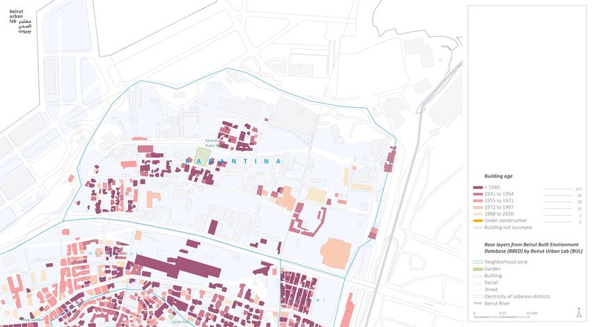
6a. Quality and Condition of the Housing Stock
Assessing Karantina revealed a diversity of housing typologies.
Courtyard houses, old villas, and apartment buildings are mainly
the typologies found. Most apartment buildings range between
one to three floors, and few between four to seven (Map 4), and
the area doesn’t count residential tower buildings like nearby Mar
Mikhael. Nevertheless, the quality of construction in Karantina is
generally flimsy, reflecting the poverty of the population. Before
the blast, most buildings’ structure had signs of deterioration
reflecting poor maintenance and neglect. Floors, roofs, internal
and external walls needed maintenance either through total
38
rebuilding or substantial repair. Several interviews showed that
before the blast, houses suffered from humidity and water
leakages. These conditions were considerably worsened by the
impacts of the August 4 blast. Now, most of the old buildings
stand structurally damaged, with internal and external walls and
Figure 9. New buildings
39
ceilings affected. The poor conditions of the residential houses
constructed in Karantina.
Source: Abir Cheaitli, 2020.
are not a surprise since most residential buildings date back to
the 40s and 50s (Map 5), and maintenance of building conditions
was not an option for the low-income inhabitants who are mostly
renters.
At the beginning of the reconstruction processes after the blast, a new layer of distinction between
the neighborhoods (al-Saydeh and al-Khodor) was added due to the quality of building upgrades.
Living conditions were either upgraded or downgraded according to the reconstruction processes.
Al-Saydeh was being built in a consolidated housing typology; the exterior and interior structures
and materials are durable and of solid quality. While in al-Khodor neighborhood, which hosts more
vulnerable groups, reconstruction was slower, more ad-hoc, and frailer. In-between, around Senegal
Street (Map 8), a pattern of self-repair and private actors’ funds were more visible. However, as of
December 2020, many housing facilities on al-Khodor and Senegal are being re-worked and
repaired by the Norwegian Refugee Council (NRC) and the United Nations Development Programme
(UNDP), who are repeating poor work already done by previous NGOs. The NRC and UNDP began
physically rehabilitating homes roughly three months after the blast as they were doing a very
detailed assessment of the damages.
38
UN-habitat. (2012, July 12). Rapid Profiling of Seven Poor Neighborhoods in Beirut City.
https://unhabitat.org/sites/default/files/download-manager-files/Rapid%20Profiling%20final.pdf
39
OEA Survey.
15 | KARANTINA URBAN SNAPSHOT | Working document6b. Tenancy Arrangements
Interviews conducted by BUL recovery team with approximately 60 residents in Karantina between
August and November 2020 indicated that access to housing was commonly happening through
rentals. These interviews showed the following types of rental arrangements:
1. Old rental contracts held by Lebanese families, particularly in the neighborhood of
al-Saydeh, are inhabited mostly by elderly residents;
2. New rental contracts;
3. Informal temporary agreements typically govern access to housing for Syrian
refugees and Ethiopian migrant workers in a compacted crowded condition.
The interviews also showed that there are still old rental contracts in the neighborhood, but new
contracts are more frequent. Old tenants’ monthly payments range between 500,000 LBP to
1,500,000 LBP per year. Households are typically constituted of nuclear families. However,
refugees whose financial means are limited sometimes share the same apartment as mentioned
above.
Interviews with residents as well as a review of about 10 property titles from Karantina revealed the
multiplicity of ownership as a common pattern in this area. This is an important challenge as many
apartments are held in shares by numerous stakeholders, typically multiple heirs. This often
entangles building development and/or replacement with conflict among multiple heirs. More
generally, land sales are slow in the area with land and apartment prices varying considerably from
40
one area to another: between al-Saydeh, al-Khodor, and the Senegal Street stretch.
6c. Housing Market Conditions
Karantina does not have an active market of housing and/or property units. Since 1998, very few
buildings were constructed. Map 6 shows that only three construction permits were filed between
41
1996 till 2018. It is expected that the post-blast classification of buildings undertaken by the
Directorate General of Archeology (DGA) in August and September 2020 will increase restrictions
on selling property or developing new buildings. Nonetheless, the area is desirable for developers
given the area’s strategic location.
To date, property speculation remains limited in the area. the BUL survey showed low vacancy
rates: no vacant apartments were detected in the neighborhood, in strong contrast with other
42
areas. On the contrary, overcrowding was observed in several housing units with a large number
of occupants/room. Another indicator of the slow housing market is the low number of publicly
43
subsidized loans that BUL allocated in the neighborhood. Only five apartments in three buildings
in al-Saydeh have benefited from the subsidized public loan of the Public Corporation for Housing
(PCH) in this neighborhood (Map 7) since 1997, indicating that few housing transactions are actually
occurring on the ownership level.
40
A resident from al-Saydeh owns an apartment in a lot that holds two buildings, and the two buildings are
owned by 12 individuals related to one family. Each building consists of three apartments. He mentioned that
before the blast, there was a plan to sell the lot for 12,000 USD per m² and regretted that the contract was
canceled after the blast. The buyers changed their mind. Meanwhile, an interview with a resident from al-
Khodor neighborhood mentioned that his parents own an apartment in a three-story building, and the other
two floors are owned by his uncles. One month after the blast, a land purchaser offered to buy the parcel for
3,000 USD per m², but the owners refused because they were unwilling to sell at what they deemed a low
price.
41
Data about building permits was obtained by the Beirut Urban Lab from the Order of Engineers and
Architects in Lebanon in 2019 and all data points were surveyed to double-check their validity. Please check
the Methodology section in the beginning of this report or visit the BBED website for the detailed methodology
used to collect and analyze the data.
42
Measured by the 2018 BBED survey for all constructions after 1996.
43
Estimate based on the BBED mapping of the publicly subsidized loans of the PCH, Beirut Urban Lab records.
16 | KARANTINA URBAN SNAPSHOT | Working document7. Local Economy
Karantina plays a central role as a “backyard” of the city’s economy. To begin with, historically and
now, the neighborhood serves as a reservoir of labor that supports the nearby port and industries.
It continues to do so for them, as well as numerous refugees and migrant workers who also conduct
domestic work. Karantina also provides the land needed to serve the city. This includes the now-
closed slaughterhouse and RAMCO, a waste management treatment facility, parking for the
municipal vehicles, the public hospital, Beirut fire brigade, and a flour mill. As mentioned above, the
relatively lower price of land has also rendered it desirable for some of the cultural industries and
emerging economy that spilled over to Karantina from the Mar Mikhael neighborhood (Maps 11).
Nevertheless, developments in the economy patterns of Karantina did not modify the social status
in this community. Karantina’s wave of refugees stigmatized the area as a low-income working-class
neighborhood that provides cheap labor to local industries. The interviews conducted in the
neighborhood revealed that many residents work in unskilled jobs such as taxi drivers, valet parking
attendants, or delivery drivers. Many among them worked in the nearby slaughterhouse, which was
closed down in 2014 due to severe health threats posed by the minimum health and hygiene
44
conditions. It is worth remembering that unskilled workers suffer disproportionately from the
ongoing financial crisis.
8. Public Spaces
Unless specified otherwise, all
information in this section is based on
direct observations in fieldwork
conducted in Fall 2020.
A Municipal Park
There is only one municipal park in the
neighborhood. Property records indicate
that this park was created in 1956
through the expropriation of a private lot
and earmarked as a public park for the
community (Map 9). The park is
strategically located in the middle of the
neighborhood. It was rehabilitated in
December 2016 after the municipality
approached landscapers Greener on the
other side in 2011 to re-design the garden. Figure 10. Plan and images of the park in
The landscapers teamed up with Karantina. Source: www.landezine-award.com.
Tandemworks, an NGO that launched an
open call for landscapers to design the
park. The competition was won by Catalytic Action, and the park was simply named “Karantina play
garden.” The new design objective was to connect two neighborhoods through a public open space.
The designers saw an opportunity for “a platform for reconciliation between past and present,
44
See “The disaster that is the Karantina slaughterhouse”, https://ecocentra.wordpress.com/2015/01/21/the-
disaster-that-is-the-karantina-slaughterhouse/
17 | KARANTINA URBAN SNAPSHOT | Working documentenabling grounds of encounter between
different communities and cultures, and
45
generations.” A resident mentioned that
each Sunday, the priest of al-Saydeh Church
invites children from both neighborhoods to
the Karantina garden, to gather, play, and
participate in activities. But according to
interviews, some Lebanese families avoid
sending their kids to play when they know
there are Syrian children at the park.
The park has been closed due to the COVID-
19 pandemic. The municipality took this
decision because many children had been
gathering in the park after school closures,
exacerbating the risk of contamination
during the pandemic.
Sidewalks and Streets
Sidewalks and streets are relatively
dilapidated in Karantina, particularly in al-
Khodor neighborhood. Many streets need
maintenance and improvements. Figure 11. Quality of public spaces (streets and
Infrastructure is visibly breaking down. Some sidewalks). Source: Abir Cheaitli, 2020.
sidewalks are difficult to walk on because
they are too narrow (e.g., sometimes less
than one meter wide); others are totally
broken down or interrupted by various
elements such as cement blocks or metal wires.
Aside from their poor physical conditions, open public spaces in Karantina are heavily militarized.
Streets, sidewalks, corners, and leftover spaces are often blocked with security elements. Many of
these elements are abandoned and seem to have no functional role.
In addition, the neighborhood counts many open spaces in the form of private lots. Potentially
unbuildable areas, these lots may be littered with waste and/or abandoned industrial equipment.
Despite the poor quality of public spaces, researchers have found that many residents keep a deep
46
relationship with the spaces that they inhabit. Spaces such as alleys, ground floors, lobbies,
porches, and sidewalks are meeting points for women to socialize and for children to play.
After the blast, these spaces were transformed into coordinating points between neighborhood
residents and aid agencies. During fieldwork, and upon doing interviews, residents instantly offered
seating on plastic chairs located beside a street or on sidewalks (fig.12). Social networks and the
sense of being part of the street life in Karantina has created a sense of security among the
residents in such open public spaces. When interviewed, women asserted that they feel safe walking
down the streets at night, and they articulated this by showing pride about being part of the
neighborhood and its community.
45
Landezine. (2020). Karantina Play Garden: A Space for Encounters. Landezine International Landscape
Award LILA. https://landezine-award.com/karantina-play-garden-a-space-for-encounters/
46
For more, see Al-Harithy, H., & Yassin, B. (2020, October 6). Post-Disaster Karantina: Towards a People-
Centered Heritage-Led Recovery. The Public Source. https://thepublicsource.org/post-disaster-karantina-
towards-people-centered-heritage-led-recovery
18 | KARANTINA URBAN SNAPSHOT | Working documentYou can also read