POINT DEFIANCE PARK: MASTER PLAN UPDATE - TACOMA, WASHINGTON - NOVEMBER 1, 2015 PRESENTED BY: City of Tacoma
←
→
Page content transcription
If your browser does not render page correctly, please read the page content below

POINT DEFIANCE PARK:                    PRESENTED BY:
                                        BCRA, Inc.

MASTER PLAN UPDATE
                                        2106 Pacific Ave, Suite 300
                                        Tacoma, WA 98402
                                        253.627.4367
TACOMA, WASHINGTON - NOVEMBER 1, 2015   bcradesign.com
2
TABLE OF CONTENTS
Introduction Design Guidelines Implementation
Executive Summary. . . . . . . . . . . . . . . . . . . . . . . . . . . . . . . . . . . . . . . . . . . . . . . . . . . . . . . . 4 Introduction. . . . . . . . . . . . . . . . . . . . . . . . . . . . . . . . . . . . . . . . . . . . . . . . . . . . . . . . . . . . . . 30 Development Regulations / Standards. . . . . . . . . . . . . . . . . . . . . . . . . . . . . . . . . . . . . 34
Public Outreach. . . . . . . . . . . . . . . . . . . . . . . . . . . . . . . . . . . . . . . . . . . . . . . . . . . . . . . . 4 Purpose . . . . . . . . . . . . . . . . . . . . . . . . . . . . . . . . . . . . . . . . . . . . . . . . . . . . . . . . . . . . . . . . . . 30 Purpose of a Development Regulation Agreement . . . . . . . . . . . . . . . . . . . . . 34
Plan Details . . . . . . . . . . . . . . . . . . . . . . . . . . . . . . . . . . . . . . . . . . . . . . . . . . . . . . . . . . . 4 Consistency with Historic Property Management Plan. . . . . . . . . . . . . . . . . . . . . . 31 Design Standards. . . . . . . . . . . . . . . . . . . . . . . . . . . . . . . . . . . . . . . . . . . . . . . . . . . . . 34
Acknowledgments. . . . . . . . . . . . . . . . . . . . . . . . . . . . . . . . . . . . . . . . . . . . . . . . . . . . . . . . . 5 Inadvertent Discovery Plan. . . . . . . . . . . . . . . . . . . . . . . . . . . . . . . . . . . . . . . . . . . . 31 Temporary Uses and Locations due to Construction Activity. . . . . . . . . . . . 34
General Requirements . . . . . . . . . . . . . . . . . . . . . . . . . . . . . . . . . . . . . . . . . . . . . . . . . . . . 31 Amendments to Master Plan and DRA . . . . . . . . . . . . . . . . . . . . . . . . . . . . . . . . . 34
Public Review Process 1. Existing Character. . . . . . . . . . . . . . . . . . . . . . . . . . . . . . . . . . . . . . . . . . . . . . . . . . 31
Community Input. . . . . . . . . . . . . . . . . . . . . . . . . . . . . . . . . . . . . . . . . . . . . . . . . . . . . . . . . . 6 2. Sustainability . . . . . . . . . . . . . . . . . . . . . . . . . . . . . . . . . . . . . . . . . . . . . . . . . . . . . . 31 Project Review Process. . . . . . . . . . . . . . . . . . . . . . . . . . . . . . . . . . . . . . . . . . . . . . . . . . . . 35
Steering Committee. . . . . . . . . . . . . . . . . . . . . . . . . . . . . . . . . . . . . . . . . . . . . . . . . . . . 6 3. Equal Access . . . . . . . . . . . . . . . . . . . . . . . . . . . . . . . . . . . . . . . . . . . . . . . . . . . . . . . 31 Metro Parks Tacoma – Scope Definition. . . . . . . . . . . . . . . . . . . . . . . . . . . . . . . . 35
Public Meetings. . . . . . . . . . . . . . . . . . . . . . . . . . . . . . . . . . . . . . . . . . . . . . . . . . . . . . . . 6 4. Site Design. . . . . . . . . . . . . . . . . . . . . . . . . . . . . . . . . . . . . . . . . . . . . . . . . . . . . . . . . 31 Metro Parks Groups Involved in Project Reviews. . . . . . . . . . . . . . . . . . . . . . . . 35
Communications Plan - Website/Blog. . . . . . . . . . . . . . . . . . . . . . . . . . . . . . . . . . . . . . . 7 5. Building Design. . . . . . . . . . . . . . . . . . . . . . . . . . . . . . . . . . . . . . . . . . . . . . . . . . . . 31 Planning, Design and Development Review Process. . . . . . . . . . . . . . . . . . . . 35
6. Materials and Colors. . . . . . . . . . . . . . . . . . . . . . . . . . . . . . . . . . . . . . . . . . . . . . . . 32 City of Tacoma – Compliance with DRA and City Municipal Code. . . . . . . . 35
7. Screening of Mechanical Equipment, Trash, and Service Areas. . . . . . . . 32 Site Development Review. . . . . . . . . . . . . . . . . . . . . . . . . . . . . . . . . . . . . . . . . . . . . 35
Environmental Considerations
8. Landscaping. . . . . . . . . . . . . . . . . . . . . . . . . . . . . . . . . . . . . . . . . . . . . . . . . . . . . . . 32 Shoreline Environment. . . . . . . . . . . . . . . . . . . . . . . . . . . . . . . . . . . . . . . . . . . . . . . . 35
Mapped Critical Areas and Priority Habitat and Species – Grette Associates. . . . 8
Park Areas . . . . . . . . . . . . . . . . . . . . . . . . . . . . . . . . . . . . . . . . . . . . . . . . . . . . . . . . . . . . . . . . 32 Critical Areas Review. . . . . . . . . . . . . . . . . . . . . . . . . . . . . . . . . . . . . . . . . . . . . . . . . . 35
Traffic / Parking / Circulation – Tilghman Group. . . . . . . . . . . . . . . . . . . . . . . . . . . . . . . . 8
1. Forest Area. . . . . . . . . . . . . . . . . . . . . . . . . . . . . . . . . . . . . . . . . . . . . . . . . . . . . . . . . 32 Traffic and Parking Review. . . . . . . . . . . . . . . . . . . . . . . . . . . . . . . . . . . . . . . . . . . . . 36
Cultural and Historic Resources – Artifacts consulting, inc.. . . . . . . . . . . . . . . . . . . . . . 9
2. Fort Nisqually. . . . . . . . . . . . . . . . . . . . . . . . . . . . . . . . . . . . . . . . . . . . . . . . . . . . . . 32 Environmental Services. . . . . . . . . . . . . . . . . . . . . . . . . . . . . . . . . . . . . . . . . . . . . . . 36
Stormwater – BCRA Engineering. . . . . . . . . . . . . . . . . . . . . . . . . . . . . . . . . . . . . . . . . . . . . . . . 9
3. Former Camp 6. . . . . . . . . . . . . . . . . . . . . . . . . . . . . . . . . . . . . . . . . . . . . . . . . . . . . 32 Utilities. . . . . . . . . . . . . . . . . . . . . . . . . . . . . . . . . . . . . . . . . . . . . . . . . . . . . . . . . . . . . . . 36
4. Baker Tract. . . . . . . . . . . . . . . . . . . . . . . . . . . . . . . . . . . . . . . . . . . . . . . . . . . . . . . . . 33 Historic Properties . . . . . . . . . . . . . . . . . . . . . . . . . . . . . . . . . . . . . . . . . . . . . . . . . . . . 36
Master Plan Focus Areas 5. Owen Beach and Promenade. . . . . . . . . . . . . . . . . . . . . . . . . . . . . . . . . . . . . . . 33 Assigning Appropriate Mitigation. . . . . . . . . . . . . . . . . . . . . . . . . . . . . . . . . . . . . . 36
Overall Site Plan. . . . . . . . . . . . . . . . . . . . . . . . . . . . . . . . . . . . . . . . . . . . . . . . . . . . . . . . . . . 10
6. Point Defiance Zoo & Aquarium. . . . . . . . . . . . . . . . . . . . . . . . . . . . . . . . . . . . . 33 Moving Forward. . . . . . . . . . . . . . . . . . . . . . . . . . . . . . . . . . . . . . . . . . . . . . . . . . . . . . 37
Overall Site Plan Key Map. . . . . . . . . . . . . . . . . . . . . . . . . . . . . . . . . . . . . . . . . . . . . . . . . . 11
7. Entrance and Bowl. . . . . . . . . . . . . . . . . . . . . . . . . . . . . . . . . . . . . . . . . . . . . . . . . . 33
Forest Area . . . . . . . . . . . . . . . . . . . . . . . . . . . . . . . . . . . . . . . . . . . . . . . . . . . . . . . . . . . . . . . 12
8. Point Defiance Marina. . . . . . . . . . . . . . . . . . . . . . . . . . . . . . . . . . . . . . . . . . . . . . 33
Fort Nisqually. . . . . . . . . . . . . . . . . . . . . . . . . . . . . . . . . . . . . . . . . . . . . . . . . . . . . . . . . . . . . 14
9. Triangle. . . . . . . . . . . . . . . . . . . . . . . . . . . . . . . . . . . . . . . . . . . . . . . . . . . . . . . . . . . . 33
Former Camp 6 / Baker Tract. . . . . . . . . . . . . . . . . . . . . . . . . . . . . . . . . . . . . . . . . . . . . . . 16
10. Yacht Basin and Marina. . . . . . . . . . . . . . . . . . . . . . . . . . . . . . . . . . . . . . . . . . . . 33
Project Elements Spreadsheets
Owen Beach and Promenade. . . . . . . . . . . . . . . . . . . . . . . . . . . . . . . . . . . . . . . . . . . . . . 18 Project Elements Spreadsheet - By Focus Area. . . . . . . . . . . . . . . . . . . . . . . . . . . 38-41
11. Park at the Peninsula . . . . . . . . . . . . . . . . . . . . . . . . . . . . . . . . . . . . . . . . . . . . . . 33
Point Defiance Zoo & Aquarium. . . . . . . . . . . . . . . . . . . . . . . . . . . . . . . . . . . . . . . . . . . . 20 Project Elements Spreadsheet - By Estimated Construction Date. . . . . . . . . 42-45
Entrance and Bowl. . . . . . . . . . . . . . . . . . . . . . . . . . . . . . . . . . . . . . . . . . . . . . . . . . . . . . . . 22
Waterfront. . . . . . . . . . . . . . . . . . . . . . . . . . . . . . . . . . . . . . . . . . . . . . . . . . . . . . . . . . . . . . . . 24
Waterfront Phase 1. . . . . . . . . . . . . . . . . . . . . . . . . . . . . . . . . . . . . . . . . . . . . . . . . . . . 25 Appendices to the Master Plan Update
Point Defiance Marina (Public). . . . . . . . . . . . . . . . . . . . . . . . . . . . . . . . . . . . . . . . . 25 Appendix A - Historic Property Management Plan - Artifacts Consulting Inc.;
Triangle . . . . . . . . . . . . . . . . . . . . . . . . . . . . . . . . . . . . . . . . . . . . . . . . . . . . . . . . . . . . . . 26 June 2015
Yacht Basin and Marina (Private). . . . . . . . . . . . . . . . . . . . . . . . . . . . . . . . . . . . . . . 27
Park at the Peninsula. . . . . . . . . . . . . . . . . . . . . . . . . . . . . . . . . . . . . . . . . . . . . . . . . . 27 Appendix B - Transportation Analysis - Tilghman Associates; July 2015
Capital Projects / Priorities. . . . . . . . . . . . . . . . . . . . . . . . . . . . . . . . . . . . . . . . . . . . . . . . . 28
Management / Oversight of Capital Projects. . . . . . . . . . . . . . . . . . . . . . . . . . . 28 Appendix C - Existing Hydrology and Storm Drainage Requirements Report-
Parkwide Elements. . . . . . . . . . . . . . . . . . . . . . . . . . . . . . . . . . . . . . . . . . . . . . . . . . . . 28 BCRA; July 2015
Overall Site Plan Circulation Map. . . . . . . . . . . . . . . . . . . . . . . . . . . . . . . . . . . . . . . . . . 29
Appendix D - Critical Areas Existing Conditions Technical Memorandum -
Grette Associates; May 2015
Appendix E - Point Defiance Park Program: Protecting and Enhancing the
Visitor Experience - BCRA; November 2014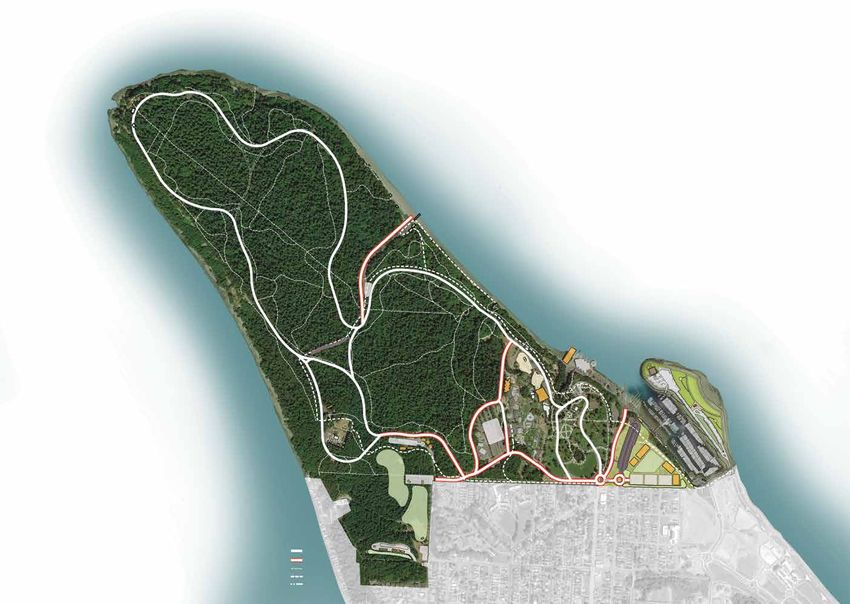
INTRODUCTION                                                           3

“Probably no other city in this country has such a beautiful natural park. Its setting, and relation

to the city is unique and ideal. Surrounded on three sides by Puget Sound, and rising some three

hundred feet above the tide level, it affords as beautiful views over land and water as can be

seen in this or foreign lands.”

“Within the boundaries of the park are also many beautiful scenes: magnificent groups of trees,

fine masses of shrubs, flowers, and ferns. Those groups along the drives have been seen and

appreciated by many, but hundred, yes thousands, of such flower and fern masses lie hid in the

almost tropical jungle of the wooded areas. The new paths and drives will open to the public

many more beauties in this natural garden. It might be well to say here that strict rules, with

zealous watching, will be necessary to prevent the ultimate destruction of these native plants

by selfish or thoughtless persons. Every citizen of Tacoma should feel it a duty and privilege to

become one of the guardians.”                                                                                      1911 Hare & Hare Master Plan, Metro Parks Tacoma Collection

“While the park will doubtless always be best known because of its beautiful natural scenery, the

expanse and natural arrangement, together with the diverse inclinations of the public, justify

the devoting of reasonable areas to other attractions. The whole park naturally falls into three

general divisions, namely: (1), athletic field; (2), zoological garden with entrance and beach;

(3), natural woodland.”
					                             —Hare & Hare, Landscape Architects, 1911 Report to Board of Park Commissioners
4

EXECUTIVE SUMMARY
In 2005, Metro Parks Tacoma began a lengthy process to develop a new master             OBJECTIVES:
plan for Point Defiance Park. Previously the only master plan officially adopted by     • Preserve, respect, and enhance the integrity of the Park’s history and beauty
the Board of Park Commissioners was the Hare & Hare Plan in 1911. An extensive          • Create an exceptional pedestrian environment
community involvement process undertaken in 2005 led to the development of              • Enhance the visitor experience through education, recreation, leisure, and
the 2008 Concept Plan, which the Park Board adopted to serve as a set of guiding           safety
principles for future enhancements. The Concept Plan in turn became the starting        • Create a destination and gathering space
point for this Master Plan Update.                                                      • Provide financially sustainable opportunities to enhance revenue for
                                                                                           maintenance and operations
In 2013, Metro Parks Tacoma conducted an internal exercise among the various            • Encourage water-related/dependent activities
departments involved at Point Defiance. The intent of this exercise was to evaluate     • Complete missing link between Ruston Way and Point Defiance
the current and future programs and facilities located within Point Defiance Park.
The resulting Program Plan helped prioritize future planning efforts and became         PUBLIC OUTREACH
another element used to help inform this Master Plan Update.                            Early on, it was recognized that significant public outreach would be necessary
                                                                                        and that it would need to go beyond the traditional public meeting format. To
In 2015, as Metro Parks undertook the next public engagement process, it became         that end, a communication plan was created to utilize the whole spectrum of
clear that the original vision of Hare & Hare still physically defines what we see at   public media, from a Web forum, Facebook, and Twitter to email blasts and print
Point Defiance today and that the landscape architects’ acclamation of the Park’s       media outreach. All of these tools provided additional opportunities to survey the
natural beauty and their tenets of preservation still resonate deeply with the          broader community and engage them in a dialogue over individual concerns. In
community. We recognized that the current planning effort needed to be treated          addition, a series of public meetings systematically discussed key elements and
as an update of the 1911 plan that both honored the original vision for Point           proposals to be included in any new plan. In total, five meetings were held that
Defiance Park and maintained the value of what this Park has meant to Tacoma.           covered the topics of reaffirming the 2008 Concept Plan, discussing the Program
                                                                                        Plan and related support facilities recommendations, vehicular circulation and        The purpose of this planning process was to develop a broad list of options and
However, Hare & Hare could not have imagined that 100 years after laying out            parking, and pedestrian and bicyclist trails and improvements. Preliminary plans      understanding of impacts and mitigation needs in order to best accommodate
their plan, the Park would receive over 3 million visits a year, nearly all of them     were presented at two additional meetings, which provided opportunities for final     the future needs of the community, which balance protection and access to the
by automobile. Recreational pursuits have changed, and parasols and beauty              adjustments prior to submission to the Board of Park Commissioners.                   natural areas with providing a venue for community gathering and recreational
pageants have given way to spandex and running events. How we use the
                                                                                                                                                                              use.
Park today puts unique demands on the original design and uses. In addition,
                                                                                        PLAN DETAILS
unforeseen environmental issues and new technologies all play a part in the
                                                                                        The public participation process helped identify seven primary Focus Areas:           Activities planned for each focus area closely reflect the current intensity of
challenges for the ongoing stewardship and management of this great natural
                                                                                        The Forest Zone, Owen Beach, Fort Nisqually, the Baker Tract/Camp 6, the              activities and the natural divisions of the park. A spreadsheet of proposed
resource. We recognize the long-lasting importance and impact that our efforts as
                                                                                        Zoo, the Entrance Bowl, and the Waterfront. Work also included a look at a            project elements is included at the end of the document for easy reference. A
a community on this updated plan will have on the future of the Park. Consistent
                                                                                        number of parkwide issues including traffic and pedestrian circulation, parking,      number of improvements for each of the focus areas were refined from the public
with the Hare & Hare approach, this Master Plan Update continues the focus
                                                                                        public transportation, and utility infrastructure. In addition, a preliminary         participation process that created the 2008 Concept Plan. These improvements
on the Park’s three major use areas: Forest, Waterfront, and Activity Area. As its
                                                                                        environmental scan was completed to assess potential impacts and development          include:
guiding principles, the Update relies on the Mission and Objectives developed
                                                                                        of strategies and mitigations to respond to identified issues relevant to critical
with the community for the 2008 Concept Plan.
                                                                                        areas from wetlands, to bluffs, and wildlife habitat, and the overall cultural and    Forest Area
                                                                                        historical resources of the park. These scans were developed as part of the State      • Viewpoint upgrades
MISSION:
                                                                                        Environmental Policy Act (SEPA) Checklist review process. Finally, a set of General    • Pedestrian/bicyclist trail enhancements
Achieve a balance of: Past, Present, and Future…Recreation, Leisure, Education,
                                                                                        Design Guidelines has been developed with the intent to protect the integrity of
Conservation, Preservation, History, and Progress.
                                                                                        the Park’s character and aesthetics as new facilities are added.                      Fort Nisqually
                                                                                                                                                                               • Native American plank house
                                                                                                                                                                               • Parking and roadway upgrades+New restroom
                                                                                                                                                                               • Shelter restoration
5
ACKNOWLEDGMENTS
Park Board Commissioners
Baker Tract/Camp 6 Parking Larry Dahl
• New picnic shelter • Consolidation at existing parking areas Erik Hanberg
• New Environmental Learning Center • Expansion of the Zoo lot with a deck alternative Aaron Pointer
• Parking & restroom • Expanded parking at the Triangle site Tim Reid
• Relocated dog park Andrea Smith
• Nature adventure play area Pedestrian/Bicyclist
Executive Director
• Maintenance facilities • Creation of new unshared pathways from the entries to major destinations Jack C. Wilson
including the Zoo, Fort Nisqually, and Owen Beach
Owen Beach and Promenade • Continued closure of the outer loop to vehicular traffic and pathway The Steering Committee
• New picnic shelter enhancements Gail Cram, Fort Nisqually Foundation
• Replace concessions and add new restrooms Tim Hummel, Tacoma Yacht Club
• Kayak boat launch Infrastructure Upgrades Larry Norvell, The Zoo Society
• Parking lot upgrades • Overlook improvements for safety and environmental improvements Krystal Kyer, Tahoma Audubon Society
• Utility upgrades Bob Myrick, Tacoma Wheelmen
Aaron Blaisdell, Business & Responsive Agency, Park Board Advisory Council
Point Defiance Zoo & Aquarium • Trail upgrades and signage improvements
Ginny Eberhart, West End Neighborhood Council
• New Environmental Learning Center • Continued forest management Ken Kingsbury, West End Neighborhood Council
• New Pacific Rim Aquarium M. ‘Morf’ Morford, North End Neighborhood Council
• Improved Rocky Shores and Polar Bear exhibits Ricardo Noguera, City of Tacoma
• Parking expansion Victor Celis, City of Ruston
• Additional storage and picnic facilities Thank you to everyone who has contributed to this effort, sharing your memories, Ali Modarres, University of Washington-Tacoma
thoughts and ideas. Your input has been vital to the creation of this updated vision Nancy Albers-Miller, Pacific Lutheran University
Entrance and Bowl for Point Defiance Park. We have been given a magnificent gift, not only with this Bryan Flint, Greater Metro Parks Foundation
• Roundabout entry Park, but with the vision and care that brought it through the last 100 years. This Diane Wiatr, City of Tacoma
• New gardens and upgrades to existing gardens plan is a start of moving the community and Point Defiance through the next Dick Dorsett, Culture & Heritage, Park Board Advisory Council
Jon Ketler, Tacoma Public Schools
century.
Karen Veitenhaus, The Zoo Society
Waterfront Jennifer Wynkoop, Active Living & Community Wellness Park Board Advisory Council
• Marina upgrades Sincerely, Jane Moore, Active Living & Community Wellness Park Board Advisory Council
• New boat trailer parking Silvia McClung, Tacoma resident
• Ruston Way trail connector Liz Satterthwaite, Nature & Environment Park Board Advisory Council
• Event plaza Bliss Moore, Sierra Club
• New park amenities on the Peninsula
• Park amenity buildings Jack C. Wilson, Executive Director Metro Parks Staff
Metro Parks Tacoma Marina Becker Curtis Hancock Kris Sherman
In addition, parkwide improvements include: Jennifer Bowman Mary Kay Henley Roger Stanton
Rick Cottey John Houck Shon Sylvia
Circulation Whitney DalBalcon Melissa McGinnis Debbie Terwilleger
Tresa Edmonds Roxanne Miles Michael Thompson
• Two-way traffic flow between Pearl Street and Mildred, providing direct
Doug Fraser Julie Parascondola Sheree Trefry
access to the Zoo, Fort Nisqually, and the Waterfront
Gary Geddes Hannah Ramsay Mary Tuttle
• A roundabout entry at Pearl Street Susan Gordon Elaine Rasmussen Anne Winters
• Continue scheduled closing of the outer loop of Five Mile Drive
BCRA
Christine Phillips, AICP Aaron Locke Erin Knuth
Gareth Roe, AICP Eric Streeby, RLA
6 PUBLIC REVIEW PROCESS
COMMUNITY INPUT
Metro Parks continues to be committed to an open public participation process STEERING COMMITTEE
and understands the importance of this in order to move forward with Destination Breakout sessions were held for projects that were moving ahead of the Master
Point Defiance. Since the adoption of the 2008 Concept Plan, Metro Parks has A Steering Committee, formed in January 2015, was made up of citizens Plan so the public would be informed of that work. Consultants for the Point
hosted numerous informational forums and made presentations throughout the representing groups or organizations including The Zoo Society, Tacoma Defiance Zoo & Aquarium presented an overview of plans for the new aquarium
community on what a new vision for the Park could look like. With the passing Wheelmen, Sierra Club, North and West End Neighborhood Councils, Cities of and the joint education building, both of which are within the fence line of the
of the 2014 Park Improvement Bond, and a commitment for a new aquarium and Tacoma and Ruston, Tacoma Public Schools, Greater Metro Parks Foundation, zoo. Consultants for the Waterfront Phase I project presented ongoing work at
other enhancements within the Park, it was time to reaffirm and advance the Pacific Lutheran University, University of Washington–Tacoma, and others. The the Triangle addressing stormwater and design development of a new trail and
vision set in 2008. committee’s purpose was to serve as a sounding board for planners and provide pedestrian bridge.
an ongoing source of input.
23 people participated in at least one of the four steering committee meetings February 26 – Program and Support Facilities
that took place between January and April 2015. Each steering committee Based on feedback from the first meeting, specific program and support facility
meeting occurred before the month’s public meeting and served as a forum for options were presented for discussion. This included an overall assessment of the
updates from planners and comments from committee members. Committee Park into 3 zones of intensity, from the most active zone at the entrance of the
members critiqued both the content and delivery of each month’s public meeting Park, a central active area, and the least active area being the forest. Development
presentation. They also considered outreach efforts, survey methods, and the planned for each area corresponds to the level of intensity consistent with the Park
growth of community input as the process continued. Mission and Objectives, to maintain the character of the Park and move toward a
pedestrian-focused environment.
One outcome of this meeting resulted in shifting a proposed Nature Play use out
PUBLIC MEETINGS
of the edge of the Forest Zone to align more with proposed education and active
uses in the Former Camp 6 / Baker Tract area.
The 2015 meetings were a valuable source of public input and dialogue. Surveys
were distributed in these meetings and served as an additional source of public
March 26 – Circulation: pedestrian, bike, auto, shuttle, and parking
input.
This meeting discussed existing circulation and parking issues, and anticipated
growth and impacts. Key elements included suggestions for rerouting traffic,
The first public meeting, held at the Pagoda, brought nearly 200 people; such
increasing parking near the key use areas, and creating an unshared pedestrian /
a large number that subsequent meetings were moved to the more spacious
bicycle path throughout the Park.
Point Defiance Zoo & Aquarium Education Building. These meetings helped to
January 29, 2015 Public Meeting consolidate all the public information gathered into its final form at the May Open
April 23 – Master Plan presentation
House.
For this meeting all previous work was combined along with public comments
and suggestions as appropriate into a draft Master Plan Update. Additional issues,
January 29 – Project overview: Zoo projects and Waterfront Phase I
most notably the entrance roundabout and roadway directions, were discussed
This public meeting was an introduction to the process. Beginning in 2005, Metro
and input was solicited.
Parks spent several years performing public outreach that culminated in the 2008
Concept Plan. This was presented as the starting point for this new public process
May 28 – Open House
to reaffirm the findings from 2008 and/or make adjustments for moving forward.
This open house gave the public a final opportunity to review and make
Additionally in 2014, Metro Parks’ staff went through an internal process resulting
comments on the completed Master Plan Update prior to submission to the
in the Destination Point Defiance Program Plan. The Program Plan was a more
Board of Park Commissioners for their review and consideration for adoption.
detailed look at improvements suggested through the Concept Plan as to how
Opportunity was also provided to once again see plans for the new Aquarium,
they could be advanced to provide an increase in services, recreation programs,
Joint Education Building, Waterfront Phase 1, and other current activities within
and educational opportunities. At this first public meeting the ongoing work and
the park.
the need for a more effective City process was discussed, as well as an overview of
what the next few months would bring.
PUBLIC REVIEW PROCESS                                                                                                                                    7

                                                                                                                                                                           Email blasts
COMMUNICATIONS PLAN - WEBSITE/BLOG                                                                                                                                         The monthly Metro Parks Today e-newsletter featured the master plan process
                                                                                                                                                                           from January through May. Visitors to DestinationPointDefiance.org also were able
Metro Parks Communications staff and planners began with the premise that                                                                                                  to sign up for email updates on the process.
not everyone in the district could attend a public meeting. In addition to helping
traditional news media cover the master plan process, Metro Parks set out to use
its own tools to disseminate information and develop two-way communication                                                                                                 PUBLIC COMMENT LETTERS
with the public.
                                                                                                                                                                           Draft Copies of the Master Plan Update were posted on Metro Parks Tacoma’s
Metro Parks’ staff distributed posters and information cards about the process to                                                                                          “Destination Point Defiance” website and several comment letters were received
community centers, libraries, and county offices, and to Metro Parks’ community                                                                                            from various groups, public agencies and, individuals including; The City of
liaisons, who spoke directly to people in specific organizations. Local news media                                                                                         Tacoma’s Bicycle and Pedestrian Technical Advisory Group (BPTAG), West End
also gave the process exposure. To promote a conversation beyond the public                                                                                                Community Council and other interested individuals. Most comments and
meeting format, staff used multiple tools:                                                                                                                                 suggestions from these letters were responded to and were incorporated into the
                                                                                                                                                                           master planning process as deemed appropriate.
Web
The tagline “Destination Point Defiance” had been used in earlier marketing
tools and it was decided to continue to market under that heading for ongoing        MindMixer
outreach. Staff built the DestinationPointDefiance.org URL as a go-to source         Metro Parks began using MindMixer, now called mySidewalk, as an online forum
of information about the process. Content increased throughout the process,          for people to discuss proposals and give input.
and by May the site included a calendar of public meetings and other events, a
link to an online forum for community discussion, PDF files of public meeting        Direct invitation
presentations and information about the Development Regulation Agreement             Just as Metro Parks’ staff invited members of some groups to join the steering
(DRA), Destination Point Defiance and the 2008 Concept Plan, information about       committee, they encouraged representatives of other groups to participate in the
each of the major elements of Destination Point Defiance, such as the Master Plan    general public meetings and the rest of the process. The first round of invitations
and Waterfront Phase I, and compilations of public comments.                         went to groups with close ties to the park, such as Fort Nisqually volunteers,
                                                                                     Tacoma Yacht Club, and Tacoma Public Schools. The second round extended
                                                                                     the outreach to organizations with broader ties, like the Tacoma Urban League,
                                                                                     AMVETS, and the Korean Women’s Association. Community liaisons were kept up
                                                                                     to date on the process and supplied with invitation cards, fliers, maps, and other
                                                                                     printouts to take to their groups.

                                                                                     Facebook and Twitter
                                                                                     To support Point Defiance Park, Metro Parks’ staff created a dedicated Facebook
                                                                                     page in late 2014 and set a goal of 1,500 fans by March 1. The goal was met early,
                                                                                     and by May the number of fans exceeded 5,000. Staff used the Point Defiance Park
                                                                                     and Metro Parks Tacoma Facebook pages, and the Metro Parks Twitter account, to
                                                                                     announce meetings, send meeting reminders, and give updates on the process,
                                                                                     with nearly all posts linking to the DestinationPointDefiance.org web page. Paid
                                                                                     social media advertising extended the reach to many in Metro Parks’ social media
                                                                                     target audience. Social media also served as a source of public input about the
                                                                                     process, and comments were pulled into reports for BCRA.
8                                                                                       ENVIRONMENTAL CONSIDERATIONS

MAPPED CRITICAL AREAS AND PRIORITY                                                      TRAFFIC / PARKING / CIRCULATION –
                                                                                                                                                                                  •   Provide new boat trailer parking to consolidate and formalize parking for
HABITAT AND SPECIES – GRETTE ASSOCIATES                                                 TILGHMAN GROUP                                                                                boat trailers (construction began July 2015)
                                                                                                                                                                                  •   Expand parking at Owen Beach by using the area located at the top of the
Early in the master planning process, Grette Associates was engaged to conduct          The Tilghman Group was hired to prepare a Transportation Analysis for the                     existing lot to meet demand on busy days. Approximately 60 new spaces
a review of existing databases to determine natural resource constraints. These         Development Regulation Agreement at Point Defiance Park. Their report describes               could be added
included Priority Habitats and Species, the National Wetland Inventory, U.S. Fish       existing transportation systems, identifies seasonal and daily variation in the Park’s    •   Add permanent parking to the former Camp 6 site to support its uses. 120
and Wildlife Service data points, and local spatial information. Field investigations   traffic and parking demands, forecasts increases in traffic and parking based on              stalls are proposed
were conducted in areas generally believed to be proposed for future work               the proposed improvements, and evaluates future traffic operations. The report            •   Create a limited amount of parking at key trailheads on Five-Mile Drive
according to current planning scope. The purpose was to verify the presence of          also recommends actions to improve pedestrian and bicycle circulation, traffic            •   Re-stripe vehicle parking lots throughout the park where feasible to increase
natural resources and critical areas, document their conditions, and identify any       operations, and parking throughout Point Defiance Park. The Transportation                    efficiency
undocumented areas. The results of the data review and field investigations were        Analysis for the Master Plan was prepared in close coordination with City of
evaluated with respect to Tacoma’s Critical Areas Preservation Ordinance (TMC           Tacoma Public Works Staff.
13.11) and Shoreline Master Program (TMC 13.10).
                                                                                        As part of the Master Plan and Development Regulation Agreement with the City
The resulting document confirmed the presence of several wetlands and identified        of Tacoma, Metro Parks has proposed a variety of expanded functions and new
two new probable wetland features. Stream locations were verified, as well as the       uses within the park. The Tilghman Transportation Analysis summarized these
locations of geologically hazardous areas (steep slopes). Development constraints,      development changes in three phases, at five-year intervals.
including buffers and setbacks, were identified. The presence or absence of bald
eagle nests was also documented. The entire park is mapped as a biological              In order to support the proposed changes and improvements with appropriate
diversity area and corridor for terrestrial species. There are no development           access and parking, and to improve walking and bicycling in the park, the
constraints associated with those specific designations.                                following actions related to transportation and circulation are being evaluated in
                                                                                        the Master Plan:
Fish and Wildlife Habitat Conservation                                                    • Construct a new traffic roundabout at the Pearl Street entry
Areas (FWHCAs) include priority                                                           • Convert the internal road from the Zoo to Pearl Street to two-way flow and
habitats and species. All of Point                                                           extend two-way operation past the Zoo to Fort Nisqually                             The Tilghman analysis of the proposed improvements at Point Defiance Park
Defiance Park is considered a FWHCA                                                       • Reallocate the lane now used for access to the boat ramp for use as a holding        identified several transportation-related impacts resulting from the proposed
as it is mapped by Washington                                                                lane for the ferry                                                                  future improvements. These identified impacts are experienced mostly during
Department of Fish and Wildlife                                                                                                                                                  busy summer weekends and include:
(WDFW) as a priority habitat                                                            New improvements were also reviewed with regards to pedestrian and bicycle                 • Increased congestion at the intersection of N. Pearl Street and N. 51st Street
(biodiversity area and corridor). Per                                                   access throughout Point Defiance Park. They include:                                          on summer Saturdays
TMC 13.11.520, “no development shall                                                      • Creating a protected shared-use pathway by extending and widening the                  • Potential parking shortages along the waterfront and at Owen Beach
be allowed within a FWHCA with                                                               existing path from the newly proposed bridge across the waterfront access
which state or federally endangered,                                                         road to Owen Beach                                                                  Recommended mitigation measures to address these impacts were identified in
threatened, or sensitive species                                                          • Creating a new walking path from the Pearl Street entrance to the Zoo and            the Tilghman report.
have a primary association without                                                           beyond to the former Camp 6 area and Fort Nisqually
approval from the City of Tacoma and/                                                                                                                                            Bicycle and pedestrian safety is an important aspect of the Point Defiance Park
or WDFW.” Proposals to complete                                                         Bicycle and pedestrian circulation, access and safety were analyzed at the master        Master Plan Update, especially in those areas of the park where they interact with
activities within an FWHCA may have                                                     plan-level during this exercise. Future planning efforts for each of the focus areas     vehicles. A thorough technical analysis and further design work will be needed
to submit a Habitat Management                                                          within the park will include detailed discussions and further analysis to take an in-    to ensure the safe integration of pedestrian, bicycle and vehicle circulation.
Plan (HMP) to demonstrate that the                                                      depth look at pedestrian and bicycle access, circulation and, safety.                    As the new facilities, programs and other physical improvements identified in
development proposal would avoid                                                                                                                                                 the Master Plan Update are implemented across the park, future planning and
or minimize impacts to FWHCA                                                            Parking within the Park was analyzed as well and the following improvements              design efforts will include detailed analysis of vehicular, pedestrian and bicycle
management areas.                                                                       were proposed:                                                                           circulation, bicycle parking, access and, safety issues. The City of Tacoma Bicycle
                                                                                          • Deck a portion of the Zoo lot to create additional parking spaces to meet the        and Pedestrian Technical Advisory Group, Tacoma Wheelmen, other formalized
                                                                                             Zoo’s design day needs                                                              bicycle advocacy groups and, the general public will be invited to help inform
                                                                                          • Provide parking at the Triangle to meet its future needs (approximately 450          future planning efforts related to future capital and infrastructure improvements
                                                                                             spaces)                                                                             to Point Defiance Park.
ENVIRONMENTAL CONSIDERATIONS                                                                                                                                                9

CULTURAL AND HISTORIC RESOURCES –                                                       STORMWATER –                                                                            MASTER PLAN FOCUS AREAS
ARTIFACTS CONSULTING, INC.                                                              BCRA ENGINEERING
                                                                                                                                                                                The next two pages have graphics of the overall site with a key map that locates
The purpose of the Historic Property Management Plan (HPMP) is to provide               A stormwater report was prepared providing information related to the existing          each of the Master Plan seven focus areas. The pages following those cover each
information on the historic building structures, objects, circulation networks,         storm drainage basins within Point Defiance Park and identified storm drainage          focus area and include an enlarged graphic with the key elements located, a
archaeology, traditional cultural properties, and landscapes within the Park.           mitigation that will be required as development occurs within the Park in               paragraph or two summary of the area, and then more detailed information about
The HPMP provides the background to streamline local, state, and federal                accordance with the Point Defiance Park Master Plan Update.                             each proposed element.
regulatory compliance, guide treatment of the identified historic properties, and
inform education and interpretive opportunities.                                        The site has approximately 19 separate threshold discharge areas (storm drainage        Each focus area will continue to be programmed in more detail and will have
                                                                                        basins) that discharge directly to Puget Sound either through an outfall, ditch, or     ongoing public outreach as plans are refined prior to final implementation. As
The HPMP provides a tool to make the following goals, articulated in many of the        overland flow, and each was analyzed in the report for existing land use, storm         each area plan is developed more fully, they will be added to this Master Plan as
recent Metro Parks Tacoma planning documents, more accessible:                          drainage systems and patterns, and proposed improvements.                               appendices to the document.
  • Support and expand the Historic and Cultural Assets Inventory
  • Guide and prioritize treatment of historic properties                               The following is a list of minimum requirements to be reviewed with future
  • Provide guidance on property and cultural landscape stewardship                     development projects:
  • Provide guidance on regulatory compliance                                            • A stormwater site plan will be prepared for individual projects within the
  • Support education and interpretation goals of park programming                           Park as they are developed. The report provides information related to the
                                                                                             existing conditions within the storm drainage basins on the site
The park may be eligible for listing in the National Register of Historic Places         • A Construction Stormwater Pollution Prevention Plan (SWPPP) will be
(NRHP) and Washington Heritage Register (WHR) as a district at the local level of            prepared for individual projects
significance under criteria A, C, and D. The park also may be eligible for listing in    • Source control Best Management Practices (BMPs) will be selected and
the Tacoma Register of Historic Places (TRHP).                                               designed for individual projects
                                                                                         • Except in areas where continuing the current drainage patterns will result in
There are currently three listed built environment properties within the park: the           further accelerating bluff erosion, natural drainage patterns and discharge
Point Defiance Streetcar Station (Pagoda), Fort Nisqually Granary and Factor’s               locations will be maintained. Where maintaining current discharge locations
House, and the Fort Nisqually Restoration.                                                   will likely result in further bluff erosion, stormwater from developed projects,
                                                                                             or as part of a conservation project, will be directed to a piped conveyance
Other historical features, such as the ruins of the old Bear Pit in the Bowl, will be        system or fully dispersed in native vegetation
evaluated and further documented if future projects or programs identified in this       • Where feasible, Roof Downspout Control BMPs, Dispersion, Soil Quality BMPs,
Master Plan Update are to locate in the vicinity of these features.                          and Tree Retention and Transplanting BMPs will be selected and designed for
                                                                                             individual projects
                                                                                         • Projects within the Park that exceed the current thresholds for water
                                                                                             quality treatment in Section 3.4.6.1 of the Washington State Stormwater
                                                                                             Management Manual (SWMM 2012) will provide water quality treatment for
                                                                                             all pollution generating surfaces
                                                                                         • If individual projects within the Park propose to discharge to a wetland, they
                                                                                             will be required to comply with the Wetland Protection requirements in the
                                                                                             SWMM
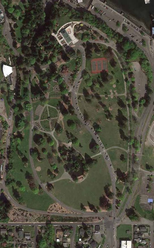
10 MASTER PLAN FOCUS AREAS
1
OWEN BEACH AND PROMENADE WATERFRONT
• Add 2nd Picnic Shelter MARINA
• Replace Existing Concession and Restrooms • Improved Access to Ferry and Waterfront
OVERALL SITE PLAN • Add 2nd Level to Boathouse
With New Joint-Use Facility
• Improve Launching Ramp for Human-powered TRIANGLE
Watercraft
• New Boat Trailer Parking
• Restripe and Improve Existing Parking Lot
• Amenity Facilities Totaling 150,000 sf
• Provide Area for Overflow Parking
• Event Plaza
FOREST AREA • Parking for 450 Vehicles
• Realign Road and Parking at FOREST • Children’s Play Area
Gig Harbor Overlook OWEN
PENINSULA
• Viewpoint Upgrades for Safety and BEACH
• Restrooms
Bluff Protection
• Open Air Event Lawn
• Viewing Areas
FORT NISQUALLY • Parking for 100 Vehicles
• Updgrade Existing Parking
• New Native American Plank House
ENTRANCE AND BOWL
• Eliminate Parking Along Five Mile Drive (Bluff Side)
• New Roundabout at Pearl Street Entrance
• Replace Restroom Facility / Restore WPA Shelter
• New Gardens and Upgrades to Existing
• Implement Fort Nisqually Program Plan
Gardens
FORMER CAMP 6 / BAKER TRACT
• Upgrade Parking WATER
• New Environmental Learning Center / Restroom FRONT
• New Program Support Building
• New Picnic Shelter
FORT
• New Parking NISQUALLY
• New Restrooms ZOO
• Fenced Dog Park with Shelter
• Nature Adventure and Play Area
• Maintenance Facility
ENTRANCE
FORMER &
POINT DEFIANCE ZOO & AQUARIUM CAMP 6 BOWL
• New Environmental Learning Center
• New Aquarium
• New/Improved Arctic Tundra Exhibit
• Improved Rocky Shores Exhibit
BAKER
• Parking Deck over Existing Parking Lot LEGEND TRACT
One-way Road
Two-way Road
Existing Pedestrian Trail
0’ 800’ 1600’ 2400’
Proposed Unshared Pedestrian Trail
Close off or modify NorthMASTER PLAN FOCUS AREAS 11
Gig Harbor
Viewpoint Dalco Passage
Viewpoint
Vashon Island
Viewpoint
OVERALL SITE PLAN See Forest Area
Enlargement
KEY MAP
Owen
Narrows Beach
Viewpoint
See Owen Beach
Enlargement
See Point Defiance Zoo & Aquarium
Narrows Bridge Enlargement
Viewpoint See Waterfront
Enlargement
See Fort Nisqually
Enlargement
See Entrance & Bowl
See Former Camp 6 / Baker Tract Enlargement
Enlargement
NTS
North12 MASTER PLAN FOCUS AREAS
FOREST AREA
Point Defiance Park is unique among urban parks because of its old-growth
forest and location on a peninsula surrounded on three sides by Puget Sound.
Most of the park sits high above the water, with dramatic views and steep cliffs 3
that drop down to a narrow beach. The 560-acre Point Defiance forest includes
approximately 500 acres of old growth, which is a valuable asset to the citizens of
1
Tacoma and to the region, both for the ecosystem services and the recreational
and educational opportunities.
This area of the Park needs to be managed to protect this valuable resource. The
protection of the fragile bluff edge and the ecosystem must take precedence over
the human element. It requires a careful balance to manage this part of the Park
while maintaining the existing level of use.
All of the viewpoints and some of the roadways abutting the bluff edges need LEGEND
serious work in the near future to relieve pressure on and stabilize the edges.
Limiting vehicular access to these edges is critical, so pull-offs will be modified
to remove parking further off the edges. This will be a continuing work effort One-way Vehicular Circulation
through the course of the Master Plan and on through the Park’s future. Five Close off or modify
Mile Drive will continue to have periods of closure to cars, allowing pedestrians Pedestrian Circulation
and bicyclists to use the road without conflicts. Increasing the closure times and
adding a shuttle service during high seasonal use times is desirable, in order to aid
in decreasing vehicular traffic, yet enable access for those who need transport. 1 Relocate Five Mile Drive to protect bluff
Forest Area
Work in this area will be managed under the Forest Stewardship Plan created by 2 Becomes pull-off parking (no through-access)
Metro Parks in 2010. LEGEND
3 Restore WPA Picnic Shelters and Replace Restroom
One-way Vehicular Circulation
4 Trail Enhancement for Pedestrian and
Close off or Modify
Educational Opportunities; Construction of New
Trailheads
Pedestrian Circulation 4
2
1 Relocate Five Mile Drive to Protect Bluff
2 Becomes Pull-off Parking (No Through-access)
3 Restore WPA Picnic Shelters and Replace Restroom
4 Trail Enhancement for Pedestrian and Educational
Opportunities, Construction of New Trailheads
NTS
Old Growth Forest, Metro Parks Tacoma Collection
NorthMASTER PLAN FOCUS AREAS 13
Restore WPA Picnic Shelter and Replace Restrooms Two areas in the western part of the Forest Zone have been designated as
Currently, the only structures within the Forest Zone are the WPA shelter and the Washington Natural Heritage sites, and recognized as the Narrows Bluff Madrona
Restroom building at the Gig Harbor Viewpoint. The WPA shelter is in need of Forest. The primary significant natural feature is the occurrence of a very rare type
restoration work that is planned to be completed by 2018. The restroom building of old growth Douglas fir dominated forest: the Douglas fir / Pacific madrona /
will be replaced with a new structure of comparable size. evergreen huckleberry plant association.
Relocate Road Away From Unstable Bluff in Multiple Locations; Stabilize Generally, tree pruning is necessary along designated trails, roadways and in
Bluff Edge Where Possible; Improve and Enhance the Viewpoints picnic areas. Outside of trails, roads and developed areas, tree pruning should not
Work on deteriorating road and bluff conditions will be a maintenance priority be performed unless the part being removed poses a hazard or the pruning is
over the next few years. Viewpoints are being analyzed for safety issues and recommended as part of a fire or pest control plan. Any plant cutting or removal
enhancements. Parking areas may be relocated to the opposite side of roadways will follow the standards defined within the Forest Stewardship Plan.
to minimize possible impacts on the bluff edges and provide better view visibility.
Replacement of chain link fencing with other types of fences will improve visual Environment and Mitigation Aspects
compatibility while still enforcing safety. Landscaping will be maintained to • Forest and steep slope management
stabilize slopes while keeping views clear. • Restoration of historic WPA structure
• Decrease of impacts to critical areas
Provide Parking for 15-20 Cars in Area of Five Mile Drive Close-off • Decrease vehicular impacts on Forest
The desire to explore the farthest reaches of the park on foot or bicycle has • Traffic revisions and dedicated parking
resulted in the random parking of vehicles along the roadway edges. In order • Stormwater management
WPA Shelter at Gig Harbor Viewpoint to protect and manage the edges of the forested areas, closing off a small,
underutilized section of the roadway connecting the beginning to the end of the
Five Mile Drive loop has been proposed. This area can be used to park for those
who want to continue on foot or bicycle through Five Mile Drive.
Trail Enhancements for Pedestrian and Educational Opportunities;
Construction of New Trailheads
Ongoing maintenance of trails is a necessity for the positive performance of any
park. Over time some trails have become unsafe due to proximity of steep slopes,
or are impacting critical areas such as wetlands, or are simply unsanctioned. These
trails need dedicated focus to return them to a stable wooded environment.
Many of the visitors to the Park are missing out on the wealth of knowledge
that exists about the forest through the lack of interpretive signage available.
A comprehensive signage plan will be designed that will not only give trail
guidance but will also provide educational and historical information. The use of
technology, such as mobile phone applications, can be included in this plan to
supplement the information that can be accessed.
Forest Stewardship Plan
Protecting the natural forest processes for public recreation and education is the
primary long-term goal of the management of the forest zone.
Gig Harbor Viewpoint14 MASTER PLAN FOCUS AREAS
FORT NISQUALLY
The Fort was brought to the Park from Dupont, WA in the 1930s and is a
reconstruction of its original layout, containing two of the original Hudson Bay
Fort buildings. A more detailed program plan for the Fort Nisqually focus area will
be one of the first efforts undertaken in accordance with the adopted Master Plan.
Another element of historical significance was the existence of a camp for the
Civilian Conservation Corps that was in the vicinity of the current off-leash dog
park. Interpretive signage may be developed to recognize this piece of history.
There is an active bald eagle nest to the west of the Fort that will require proposed
programs or construction activity to be reviewed under the National Bald Eagle
Management Guidelines. Although bald eagles are no longer listed as a federally
endangered or state threatened species, proposed development within 600 feet
of a nest may require a management plan and adaptive management strategies.
Fort Nisqually
LEGEND
One-way Vehicular Circulation
Two-way Vehicular Circulation
Pedestrian Circulation
1 Rework Existing Parking Lot
2 New Native American Plank House
3 Eliminate Parking along Five Mile Drive (Bluff Side)
4 Replace / Relocate Restroom Facility
5 Restore WPA Picnic Shelter
6 Fort Nisqually Master Plan
NTS
NorthMASTER PLAN FOCUS AREAS 15
Internal to Fort – Renovate Kitchen and Clerk’s House and Others Master Plan of Fort Nisqually
Renovations and maintenance of existing buildings will be ongoing. At this time Design development for a master plan of Fort Nisqually is in process and the
the Clerk’s House is in need of replacement, the kitchen should be reconstructed proposed traffic modification and other prospective projects will be subject to
to be more historically correct, the Sales Shop may need significant repairs, detailed analysis and discussed through a public forum.
the Tyee House may be reconstructed, and the missing structure between the
Blacksmith Shop and Clerk’s House may be reconstructed. This is all part of the Environment and Mitigation Aspects
next planning phase. • Forest and steep slope management
• Decrease of critical area impacts
Native American interpretive Center – Plank House • Bald Eagle habitat management
Including more historic elements that feature Native American culture is a Park • Incorporation of additional element to Historic Museum
goal, and will be explored through the development of a Plank House, or Long • Preservation of historic park element
House, and programs that will be managed through this new facility. The location • Restoration of historic WPA structure
of this structure is proposed to be adjacent to the main parking lot, within the area • Traffic revisions and dedicated parking
that previously held the Never Never Land amusement park. • Stormwater management
Expansion of Agricultural Activity – Native Plants and Heritage Trees
Fort Nisqually Restoration, Summer 1934 The meadow to the north of the Fort is planned to be utilized for these activities
Fort Nisqually Collection and will include the plantings and study of historic plants and agriculture.
Restore WPA Picnic Shelter; Replace and Relocate Restroom Building; Add
Service and Storage Functions
The WPA shelter is in need of restoration work. The Restroom building will be
replaced with a new structure of a slightly larger size to include service and
storage functions, relocated further away from the Fort and closer to the existing
parking area.
Reverse Driving Direction of Loop Road around Fort; Eliminate Parking
along Bluff; Modify Existing Parking Areas to Improve Efficiency
Reversing the roadway direction around the Fort is under consideration as part of
the overall automobile circulation plan. This would allow for more direct access
from the entrances of the park to the Fort and other park destinations. This would
also allow for a logical approach and drop-off area at the front of the Fort and then
continuing to the main parking lot. Improved signage along Five Mile Drive will be
included as a tool to direct visitors to this facility.
Parking will be removed from the bluff edge through the park bluff stabilization
effort. Replacement of chain link fencing with other types of fences will improve
visual compatibility while enforcing safety. Landscaping will be maintained to
stabilize slopes and keep views clear. The main parking area will be analyzed and
re-striped, with minor modifications to edges, resulting in increased efficiency.
Factor’s House, Fort Nisqually Fort Nisqually Buildings
Fort Nisqually Collection16 MASTER PLAN FOCUS AREAS
FORMER CAMP 6 / BAKER TRACT
The Logging Museum that was called Camp 6 was added as a privately-operated
exhibit in 1964, and removed in 2011 as interest waned. The area has been
maintained as a gravel lot used for backup parking, most notably for large zoo
events such as Zoolights.
This area will be planned to serve as an Environmental Learning Center. Buildings
constructed at Camp 6 will be designed to be multiuse so they can serve varied
park programs and events. This may include nature camps, retreat facilities, and
other park-related uses.
The former Camp 6, along with the Baker Tract to the south, is seen as the best
option for providing additional educational and low-impact nature-based
recreational activities. This reasoning is partly based on the earlier use of the
site as a Logging Museum, and the relatively young forest in this area in relation
to the old growth forest to the north. In 1902, a fire on the west side of Tacoma
Camp 6 Baker Tract
consumed 600 acres of trees, including 50 acres within the park. Subsequent
logging cleared most of the Baker Tract and the Camp 6 area in the early LEGEND
1930’s. This cleared area extended as far as the area where Fort Nisqually was
reconstructed. One-way Vehicular Circulation
The secondary entrance to Point Defiance Park occurs at the southern edge Two-way Vehicular Circulation
of the former Camp 6 site and will likely see some increase in use as park road
Pedestrian Circulation
systems are revised to provide two-way access between the two park entrances
and the main destinations of the park. Encouraging the development of low key
activities in this area is consistent with the approach of keeping the development
compatible with the natural character of the park. 1 Paved Parking
2 Environmental Learning Center- 20,000 sf
3 Group Picnic Shelter
4 Restroom
5 Fenced Dog Park with Shelter
6 Nature Play Area
7 Maintenance Area
8 Outdoor Educational Venue
NTS
NorthMASTER PLAN FOCUS AREAS 17
FORMER CAMP 6 BAKER TRACT Support Parking
Multiuse Environmental Learning Center with Assembly Spaces, Storage, The Baker Tract consists of 48 acres acquired by Metro Parks in 1975. There is a Small support parking areas should be located near to planned program areas
and Public Restrooms; Multiple Buildings Totaling 20,000 SF gravel fire road running east-west that physically separates this area from the such as shelters, the dog park, and the nature recreation zone. Access to these
These facilities are proposed to be built over the course of several years. They will rest of the Park. Additionally, a portion of the tract that was used as a borrow pit areas should be directly from Mildred Street if possible.
host a number of programs and be notably education- and nature-based. has become a problem due to collecting storm drainage runoff and is noted in
the Grette Technical Memorandum as a probable wetland. The forest in this area Park Maintenance Facilities, including Maintenance Offices, Shop Buildings,
Outdoor Educational Venue with Seating for 100 contains mostly growth that originated subsequent to being cleared in the early Container Storage, Open Covered Storage, Parking, and Material Stockpiling
This seating area, intended for informal or formal outdoor presentations, would 1930’s, with some older trees remaining along the bluff edge overlooking the As the Triangle is being cleared for upcoming work, a new location needs to be
likely be placed in conjunction with a picnic shelter and restrooms at the north Salmon Beach historic community. There are two paved roads cutting through the found for maintenance facilities functions. Expansion of the existing stockpiling
end of the Baker Tract, and includes support parking. tract that give access to Salmon Beach. area at the entrance to South Salmon Beach Drive is a logical choice to consolidate
functions. This would essentially double the area currently occupied by storage
Support Parking for 125 The recommended boundary for the potential National Register of Historic and accommodate new buildings, additional stockpiling, and parking areas.
Support parking areas should be located in close proximity to planned program Places district includes those properties that contributed to the Park’s areas of Additional screening will be placed for visual aesthetics along the side of the
areas. Redesign and new uses will result in a reduction from the current 200 spaces significance and were developed within the period of significance, from 1888 to roadway.
within the existing Camp 6 gravel lot. 1941. While this doesn’t include the Baker Tract, it can be noted that the Olmsted
Brothers drafted a Preliminary Plan for the Tract to develop a single family Environment and Mitigation Aspects
Environment and Mitigation Aspects subdivision in 1917, which was never undertaken. • Forest/trail management and steep slope critical areas
• Forest management • Dedicated parking
• Decrease of impacts to critical areas such as wetlands • Wetlands and stormwater management
• Traffic revisions and dedicated parking Nature Play Area for Active Recreational Opportunities
• Stormwater management Several wooded acres within the Baker Tract, potentially extending up into Camp
6, will be utilized for nature-themed programs and activities. These are intended
for low-impact use that can occur within the trees and trails as they currently exist.
Possible elements include a playground area, ropes course, climbing structure, or
other similar activities. Minor modifications may be made if the intended activity is
deemed appropriate for this location.
Relocate Off-leash Dog Park
The location of the off-leash dog park has been actively discussed with issues
revolving around fencing of the park and dog owners who don’t follow the leash
rules. The general consensus is to move the dog park far enough away from Fort
Nisqually and the Salmon Beach community to decrease impacts from noise,
access, and parking. Ideally, dog owners should be able to directly access the dog
park from Mildred Street. This would help minimize the wandering of unleashed
dogs into areas that are off-limits.
Shelters with Running Water
At most, two new support shelters for the relocated dog park and nature
adventure recreational opportunities will be located in this area. A shelter at the
dog park would be relatively small in size, as it would provide cover and running
water. These shelters should be located in reasonable proximity to new dedicated
parking areas and for efficiency/availability of water or other utility services.
Former Camp 6 Logging Museum Off Leash Dog ParkYou can also read