Latrobe City Flood Emergency Plan - A Sub-Plan of the Municipal Emergency Management Plan
←
→
Page content transcription
If your browser does not render page correctly, please read the page content below
Latrobe City
 Flood Emergency Plan
           A Sub-Plan of the
Municipal Emergency Management Plan

  For Latrobe City and VICSES Unit(s) Moe & Morwell

             Version 1.5 September 2013
Intentionally Blank

Latrobe City Flood Emergency Plan – A Sub-Plan of the MEMP – Version 1.5 September 2013   ii
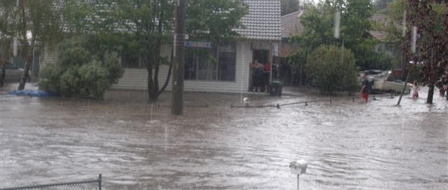
Table of Contents
DISTRIBUTION LIST ................................................................................................................................... V

DOCUMENT TRANSMITTAL FORM / AMENDMENT CERTIFICATE ...................................................... V

LIST OF ABBREVIATIONS & ACRONYMS ............................................................................................ VIII

PART 1.          INTRODUCTION ........................................................................................................................ 1

   1.1         MUNICIPAL ENDORSEMENT ............................................................................................................. 1
   1.2         THE MUNICIPALITY FLOOD RISK PROFILE ........................................................................................ 2

   1.3         PURPOSE AND SCOPE OF THIS FLOOD EMERGENCY PLAN ................................................................ 2

   1.4         MUNICIPAL FLOOD PLANNING COMMITTEE (MFPC) ......................................................................... 2

   1.5         RESPONSIBILITY FOR PLANNING, REVIEW & MAINTENANCE OF THIS PLAN ......................................... 2

   1.6         ENDORSEMENT OF THE PLAN .......................................................................................................... 2

PART 2.          PREVENTION / PREPAREDNESS ARRANGEMENTS .......................................................... 3

   2.1         COMMUNITY AWARENESS FOR ALL TYPES OF FLOODING .................................................................. 3

   2.2         STRUCTURAL FLOOD MITIGATION MEASURES .................................................................................. 3

   2.3         NON-STRUCTURAL FLOOD MITIGATION MEASURES .......................................................................... 3

       2.3.1      Exercising the Plan ............................................................................................................................... 3

       2.3.2      Flood Warning ...................................................................................................................................... 3

       2.3.3      Flood Wardens ..................................................................................................................................... 3

PART 3.          RESPONSE ARRANGEMENTS ............................................................................................... 3

   3.1         INTRODUCTION ............................................................................................................................... 3

       3.1.1      Activation of Response ......................................................................................................................... 3

       3.1.2      Responsibilities .................................................................................................................................... 4

       3.1.3      Municipal Emergency Coordination Centre (MECC) ............................................................................ 4

       3.1.4      Escalation ............................................................................................................................................. 4

   3.2         STRATEGIC CONTROL PRIORITIES ................................................................................................... 4

   3.3         COMMAND, CONTROL & COORDINATION .......................................................................................... 5

       3.3.1      Control .................................................................................................................................................. 5

       3.3.2      Incident Controller (IC) ......................................................................................................................... 5

       3.3.3      Incident Control Centre (ICC) ............................................................................................................... 5

       3.3.4      Divisions and Sectors ........................................................................................................................... 5

       3.3.5      Incident Management Team (IMT) ....................................................................................................... 5

Latrobe City Flood Emergency Plan – A Sub-Plan of the MEMP – Version 1.5 September 2013                                                                   iii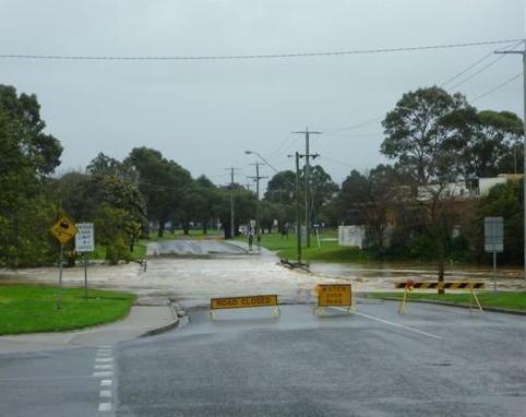
3.3.6      Emergency Management Team (EMT) ................................................................................................ 5

     3.3.7      On Receipt of a Flood Watch / Severe Weather Warning .................................................................... 6

     3.3.8      On Receipt of the First and Subsequent Flood Warnings .................................................................... 6

  3.4        COMMUNITY INFORMATION AND W ARNINGS ..................................................................................... 6

  3.5        MEDIA COMMUNICATION ................................................................................................................. 7

  3.6        RAPID IMPACT ASSESSMENT ............................................................................................................ 7

  3.7        PRELIMINARY DEPLOYMENTS .......................................................................................................... 7

  3.8        RESPONSE TO FLASH FLOODING ..................................................................................................... 7

  3.9        EVACUATION .................................................................................................................................. 7

  3.10       FLOOD RESCUE .............................................................................................................................. 8

  3.11       AIRCRAFT MANAGEMENT ................................................................................................................ 8

  3.12       RESUPPLY ...................................................................................................................................... 8
  3.13       ESSENTIAL COMMUNITY INFRASTRUCTURE AND PROPERTY PROTECTION ......................................... 8

  3.14       DISRUPTION TO SERVICES .............................................................................................................. 8

  3.15       ROAD CLOSURES ........................................................................................................................... 9

  3.16       DAM FAILURE ................................................................................................................................. 9

  3.17       W ASTE W ATER RELATED PUBLIC HEALTH ISSUES AND CRITICAL SEWERAGE ASSETS ....................... 9

  3.18       AFTER ACTION REVIEW................................................................................................................... 9
  3.19       RECORDING OF FLOOD INFORMATION ............................................ ERROR! BOOKMARK NOT DEFINED.

PART 4.        EMERGENCY RELIEF AND RECOVERY ARRANGEMENTS ............................................. 10

  4.1        GENERAL ..................................................................................................................................... 10

  4.2        EMERGENCY RELIEF ..................................................................................................................... 10

  4.3        ANIMAL W ELFARE ......................................................................................................................... 10

  4.4        TRANSITION FROM RESPONSE TO RECOVERY ................................................................................ 10

APPENDICES

   APPENDIX A - FLOOD THREATS
   APPENDIX B - TYPICAL FLOOD PEAK TRAVEL TIMES
   APPENDIX C1 - FIC TRARALGON
   APPENDIX C2 - FIC MORWELL
   APPENDIX C3 – FIC MOE
   APPENDIX D - FLOOD EVACUATION ARRANGEMENTS
   APPENDIX E - FLOOD W ARNING SYSTEMS
   APPENDIX F - M APS

Latrobe City Flood Emergency Plan – A Sub-Plan of the MEMP – Version 1.5 September 2013                                                  iv
Distribution List
The Distribution List for this sub plan is the same as in the Municipal Emergency Management Plan and
the Latrobe City Flood Emergency Plan Sub-Committee.

Document Transmittal Form / Amendment Certificate
This Municipal Flood Emergency Plan (MFEP) will be amended, maintained and distributed as required
by VICSES in consultation with the Latrobe City Council’s MEMPC.

Suggestions for amendments to this Plan should be forwarded to:

VICSES East Regional Headquarters
82a Moore Street
MOE VIC 3825

Amendments listed below have been included in this Plan and promulgated to all registered
copyholders.

 Amendment       Date of          Amendment        Summary of Amendment
 Number          Amendment        Entered By

This Plan will be maintained on the Latrobe City Council website www.latrobe.vic.gov.au.

Latrobe City Flood Emergency Plan – A Sub-Plan of the MEMP – Version 1.5 September 2013     v

List of Abbreviations & Acronyms
The following abbreviations and acronyms are used in the Plan:
 AEP               Annual Exceedance Probability
 AHD               Australian Height Datum (the height of a location above mean sea level in metres)
 AIIMS             Australasian Inter-service Incident Management System
 AoCC              Area of Operations Control Centre / Command Centre
 ARI               Average Recurrence Interval
 ARMCANZ           Agricultural & Resource Management Council of Australia & New Zealand
 AV                Ambulance Victoria
 BoM               Bureau of Meteorology
 CEO               Chief Executive Officer
 CERA              Community Emergency Risk Assessment
 CERM              Community Emergency Risk Management
 CFA               Country Fire Authority
 CMA               Catchment Management Authority
 RERC              Regional Emergency Response Coordinator
 RERCC             Regional Emergency Response Coordination Centre
 DHS               Department of Human Services
 DH                Department of Health
 DoI               Department of Infrastructure
 DEPI              Department of Environment and Primary Industries
 EMLO              Emergency Management Liaison Officer
 EMMV              Emergency Management Manual Victoria
 EMT               Emergency Management Team
 EO                Executive Officer
 FO                Floodway Overlay
 FWS               Flood Warning System
 FZ                Floodway Zone
 IC                Incident Controller
 ICC               Incident Control Centre
 IMT               Incident Management Team
 IMS               Incident Management System
 LSIO              Land Subject to Inundation Overlay
 MECC              Municipal Emergency Coordination Centre
 MEMP              Municipal Emergency Management Plan
 MEMPC             Municipal Emergency Management Planning Committee
 MERC              Municipal Emergency Response Coordinator
 MERO              Municipal Emergency Resource Officer
 MFB               Metropolitan Fire and Emergency Services Board
 MRM               Municipal Recovery Manager
 PMF               Probable Maximum Flood
 RCC               Regional Control Centre
 RDO               Regional Duty Officer
 SBO               Special Building Overlay
 SCC               State Control Centre
 SEWS              Standard Emergency Warning System
 SHERP             State Health Emergency Response Plan
 SOP               Standard Operating Procedure
 VicPol            Victoria Police
 VICSES            Victoria State Emergency Service

Latrobe City Flood Emergency Plan – A Sub-Plan of the MEMP – Version 1.5 September 2013                viii
Part 1.         INTRODUCTION
1.1     Municipal Endorsement
The Latrobe City Council is the custodian of this Municipal Flood Emergency Plan (MFEP), as a sub
plan of the Municipal Emergency Management Plan.

This MFEP has been prepared by the SES in conjunction with the Municipal Flood Planning
Sub-committee with the authority of the Municipal Emergency Management Planning Committee (refer
to section 1.6 endorsement of plan) pursuant to Section 20 of the Emergency Management Act 1986 (as
amended).

The Latrobe City Council and VICSES will undertake consultations with the communities of Latrobe City
about the arrangements contained within this plan.

This MFEP is a sub plan to the Latrobe City Municipal Emergency Management Plan (MEMP), is
consistent with the Emergency Management Manual Victoria (EMMV) and the Victoria Flood
Management Strategy (DNRE, 1998a).

The Municipal Flood Emergency Plan is consistent with the Regional Flood Emergency Plan and the
State Flood Emergency Plan.
This Municipal Flood Emergency Plan is a result of the cooperative efforts of the Latrobe City Flood
Planning Committee (MFPC) and its member agencies. The signatories below, on behalf of their
respective agencies commit to the implementation of this plan as it applies to each agency.

Paul Buckley
Chief Executive Officer
Latrobe City Council

Date:

Jamie Twidale
Regional Manager
VICSES East Region

Date:

Ricky Ross APM
Regional Emergency Management
Inspector
Victoria Police

Date:

Latrobe City Flood Emergency Plan – A Sub-Plan of the MEMP – Version 1.5 September 2013     1
1.2 The Municipality Flood Risk Profile
An outline of Latrobe City Council in terms of its location, demography and other general matters is
provided in the MEMP.
The 2011 CERM Review identified Flood as a medium risk within Latrobe City, as detailed in the MEMP.
Further risk assessment processes have identified the risks in relation to River Basins, River Systems
and Communities within Latrobe City.
Detailed flood threats, information and response information for each river system and identified at risk
community is provided in the attachments and appendices to this plan.
1.3 Purpose and Scope of this Flood Emergency Plan
The purpose of this MFEP is to detail arrangements agreed for the planning, preparedness/prevention,
response and recovery from flood incidents within Latrobe City.
As such, the scope of the Plan is to:
Identify the Flood Risk to Latrobe City;
Support the implementation of measures to minimise the causes and impacts of flood incidents
within the Latrobe City;
Detail Response and Recovery arrangements including preparedness, Incident Management,
Command and Control and Co-ordination;
Identify linkages with Local, Regional and State emergency and wider planning arrangements
with specific emphasis on those relevant to flood.
1.4 Municipal Flood Planning Committee (MFPC)
Membership of the Latrobe City Municipal Flood Planning Committee (MFPC) will comprise of the
following representatives from the following agencies and organisations:
Victoria Police (i.e. Municipal Emergency Response Co-ordinator) (MERC) (Chair),
VICSES, Regional Officer – Emergency Management
Latrobe City Council, MERO
Southern Rural Water
West Gippsland Catchment Management Authority,
Other agencies and community representatives or consultants as required.
1.5 Responsibility for Planning, Review & Maintenance of this Plan
This Municipal Flood Emergency Plan must be maintained in order to remain effective.
VICSES through the Flood Planning Committee has responsibility for preparing, reviewing, maintaining
and distributing this plan.
The MFPC will meet at least once per year.
The plans should be reviewed:
following any new flood study;
any change in non-structural and/or structural flood mitigation measures; and
after the occurrence of a significant flood event within the Municipality to review and where
necessary amend arrangements and information contained in this Plan.
1.6 Endorsement of the Plan
The MFEP will be circulated to Municipal Flood Planning Sub-Committee members seeking acceptance
of the draft plan.
Upon acceptance, the plan is forwarded to the MEMPC for endorsement as a sub-plan of the MEMPlan.
Latrobe City Flood Emergency Plan – A Sub-Plan of the MEMP – Version 1.5 September 2013 2Part 2. PREVENTION / PREPAREDNESS ARRANGEMENTS
2.1 Community Awareness for all Types of Flooding
Details of this MFEP will be released to the community through local media, the FloodSafe program,
websites (VICSES and the Municipality).
VICSES will co-ordinate community education programs for flooding within the Council area, with the
support of Latrobe City Council, Southern Rural Water and West Gippsland CMA, eg StormSafe /
FloodSafe.
2.2 Structural Flood Mitigation Measures
Subject to the provisions of the Latrobe City Council Planning Scheme, Latrobe City Council and SES
encourages residents and business owners / operators in potentially flood prone areas to plan and put in
place effective flood protection measures for their dwellings and business premises. This applies in
particular to areas subject to flash flooding and overland flows. Prior to taking such measures, you
should contact Latrobe City Council’s Planning department to discuss whether any proposed measures
would require a planning permit.
2.3 Non-structural Flood Mitigation Measures
2.3.1 Exercising the Plan
Arrangements for exercising this Plan will be at the discretion of the MEMPC and SES. This Plan
should be regularly exercised, preferably on an annual basis.
2.3.2 Flood Warning
Arrangements for flood warning are contained within the State Flood Emergency Plan and the
EMMV (Part 3.7) and on the BoM website.
Flood forecasting and warning systems are operated on several streams within Latrobe City by
the Bureau of Meteorology.
Comments made on behalf of the Municipality relating to Council matters must be approved by
the MERO or the Chief Executive Officer (CEO) or delegate with regard to response issues and by
the Municipal Recovery manager (MRM) or the CEO or delegate with regard to recovery issues.
The method(s) used to disseminate information to communities, particularly recovery related
information, will be decided at the time. Additional information on public information and warning
and the methods that may be considered are detailed in the MEMP. This includes the details of
appropriate media outlets.
2.3.3 Flood Information Providers
Latrobe City has flood information providers as listed in the attachments to this plan.
Part 3. RESPONSE ARRANGEMENTS
3.1 Introduction
3.1.1 Activation of Response
Flood response arrangements may be activated by the Regional Duty Officer (RDO) VICSES
Region or Incident Controller.
The Incident Controller/RDO VICSES will activate agencies as required and documented in the
State Flood Emergency Plan.
Latrobe City Flood Emergency Plan – A Sub-Plan of the MEMP – Version 1.5 September 2013 33.1.2 Responsibilities
There are a number of agencies with specific roles that will act in support of VICSES and provide
support to the community in the event of a serious flood within Latrobe City. These agencies will
be engaged through the EMT.
The general roles and responsibilities of supporting agencies are as agreed within the Latrobe
City MEMP, EMMV (Part 7 ‘Emergency Management Agency Roles’), State Flood Emergency
Plan and Regional Flood Emergency Plan.
3.1.3 Municipal Emergency Coordination Centre (MECC)
The function, location, establishment and operation of the MECC will be as detailed in the Latrobe
City MEMP.
If a MECC is established for a flood event, VICSES will provide an EMLO. The VICSES RDO /
ICC will liaise with the MECC directly. If an Incident EMT is established, the Municipality will also
maintain involvement in the Incident EMT.
3.1.4 Escalation
Most flood incidents are of local concern and an appropriate response can usually be coordinated
using local resources. However, when these resources are exhausted, the State’s arrangements
provide for further resources to be made available, firstly from neighbouring Municipalities (on a
regional basis) and then on a State-wide basis.
Resourcing and event escalation arrangements are described in the EMMV (‘State Emergency
Response Plan’ – section 3.5).
The six Gippsland Municipalities have a resource sharing agreement in place for emergency
events as detailed in the MEMP.
3.2 Strategic Control Priorities
To provide guidance to the Incident Management Team (IMT), the following strategic control priorities
shall form the basis of incident action planning processes:
1. Protection and preservation of life is paramount - this includes:
a. Safety of emergency services and other agency personnel, and;
b. Safety of community members including vulnerable community members and visitors/tourist
located within the incident area.
2. Issuing of community information and community warnings detailing incident information that is
timely, relevant and tailored to assist community members make informed decisions about their
safety.;
3. Protection of critical infrastructure and community assets that supports community resilience;
4. Protection of residential property as a place of primary residence;
5. Protection of assets supporting individual livelihoods and economic production that supports
individual and community financial sustainability
6. Protection of environmental and conservation values that considers the cultural, biodiversity,
and social values of the environment;
Circumstances may arise where the Incident Controller is required to vary these priorities, with the
exception being that the protection of life should remain the highest. This shall be done in consultation
with the State Controller and relevant stakeholders based on sound incident predictions and risk
assessments.
Latrobe City Flood Emergency Plan – A Sub-Plan of the MEMP – Version 1.5 September 2013 43.3 Command, Control & Coordination
The Command, Control and Coordination arrangements in this Municipal Flood Emergency Plan must
be consistent with those detailed in State and Regional Flood Emergency Plans. For further information,
refer to sections 3.4, 3.5 & 3.6 of the EMMV.
The specific details of the Command, Control and Coordination arrangements for this plan are provided
in Appendix C in the river system attachments to this plan..
3.3.1 Control
Functions 5(a) and 5(c) at Part 2 of the Victoria State Emergency Service Act 1986 (as amended)
detail the authority for VICSES to plan for and respond to flood.
Part 7.1 of the EMMV prepared under the Emergency Management Act 1986 (as amended),
identifies VICSES as the Control Agency for flood. It identifies DEPI as the Control Agency
responsible for “dam safety, water and sewerage asset related incidents” and other emergencies
All flood response activities within Latrobe City including those arising from a dam failure or
retarding basin / levee bank failure incident will therefore be under the control of the appointed
Incident Controller, or his / her delegated representative.
3.3.2 Incident Controller (IC)
An Incident Controller (IC) will be appointed by the VICSES (as the Control Agency) to command
and control available resources in response to a flood event on the advice of the Bureau of
Meteorology (or other reliable source) that a flood event will occur or is occurring. The Incident
Controller responsibilities are as defined in Part 3.5 of the EMMV
3.3.3 Incident Control Centre (ICC)
As required, the Incident Controller will establish an Incident Control Centre (ICC) from which to
initiate incident response command and control functions. The decision as to if and when the ICC
should be activated, rests with the Control Agency (i.e. VICSES).
Pre-determined Incident Control Centre locations are
Level 1 – Local VICSES Unit (Moe & Morwell)
Level 2 - VICSES East Region Headquarters, 82a Moore St Moe or VICSES East Region
Office, 130 Macleod Street, Bairnsdale
Level 3 – Multi Agency control facility, Franklin Street, Traralgon
3.3.4 Divisions and Sectors
To ensure that effective Command and Control are in place, the Incident Controller may establish
Divisions and Sectors depending upon the complexity of the event and resource capacities.
3.3.5 Incident Management Team (IMT)
The Incident Controller will form an Incident Management Team (IMT). Refer to 3.5 of the EMMV
for guidance on IMT’s and Incident Management Systems (IMS’s).
3.3.6 Emergency Management Team (EMT)
The Incident Controller will establish a multi-agency Emergency Management Team (EMT) to
assist the flood response. The EMT will consist of key personnel (with appropriate authority) from
stakeholder agencies and relevant organisations who need to be informed of strategic issues
related to incident control and who are able to provide high level strategic guidance and policy
advice to the Incident Controller for consideration in developing incident management strategies.
Latrobe City Flood Emergency Plan – A Sub-Plan of the MEMP – Version 1.5 September 2013 5Organisations required within the EMT will provide an Emergency Management Liaison Officer
(EMLO) to the ICC if and as required as well as other staff and / or resources identified as being
necessary, within the capacity of the organisation.
Refer to 3.5 of the EMMV for guidance on EMTs.
3.3.7 On Receipt of a Flood Watch / Severe Weather Warning
Latrobe City Council will operate as defined within their Standard Operating Procedures.
The VICSES Incident Controller/ RDO will:
Ensure flood bulletins and community information are prepared and issued to the
community;
Notify and brief appropriate officers, this includes (if established) Regional Control
Centre (RCC), State Control Centre (SCC), Council and other emergency services
through the EMT;
Assess ICC readiness (including staffing of IMT and EMT) and open if required;
Review flood intelligence to assess likely flood consequences;
Monitor weather and flood information – www.bom.gov.au;
Assess Command and Control requirements;
Review local resources and consider needs for further resources regarding personnel,
property protection, flood rescue and air support;
Monitor watercourses and undertake reconnaissance of low-lying areas;
Ensure flood mitigation works are being checked by owners ie Southern Rural Water.
Develop and issue incident action plan, if required; and
Develop and issue situation report, if required.
3.3.8 On Receipt of the First and Subsequent Flood Warnings
Latrobe City Council will operate as defined within their Standard Operating Procedures.
The VICSES Incident Controller/ RDO will:
Continue to review flood intelligence to assess likely flood consequences;
Determine what the at-risk community need to know and do as the flood develops;
Continue to warn the at-risk community including ensuring that an appropriate warning
and community information strategy is implemented;
Liaise with relevant asset owners as appropriate (i.e. water and power utilities);
Implement response strategies as required based upon flood consequence assessment;
Continue to monitor the flood situation – www.bom.gov.au/vic/flood/ and
www.bom.gov.au,
http://www.melbournewater.com.au/content/rivers_and_creeks/rainfall_and_river_level_
data/rainfall_and_river_level_data.asp; and
Continue to undertake reconnaissance of low-lying areas.
3.4 Community Information and Warnings
The Bureau of Meteorology has the responsibility for issuing Flood and Severe Weather Warnings.
VICSES, as the Control Agency, co-ordinates further community messaging.
Council has the responsibility to assist VICSES to warn individuals as required within the municipality.
Other agencies such as CFA, DEPI and VICPOL may be requested to assist VICSES with the
communication of community flood warnings.
Latrobe City Flood Emergency Plan – A Sub-Plan of the MEMP – Version 1.5 September 2013 6In cases where severe flash flooding is predicted, dam failure is likely or flooding necessitating
evacuation of communities is predicted, the Incident Controller may consider the use of the Emergency
Alert System and Standard Emergency Warning System (SEWS).
The Department of Health will coordinate information regarding public health and safety precautions.
Guidelines for the distribution of community information and warnings are contained in the State Flood
Emergency Plan.
Community information and warnings will be targeted at local, regional and state wide needs and may
include:
Emergency Alert;
Radio and Television;
Verbal Messages (i.e. Doorknocking);
Agency Websites;
VICSES Flood Storm Information Line;
Variable Message Signs (i.e. road signs);
Community meetings & newsletters; and
Social media.
Refer to Appendices C and E for the specific details of how community information and warnings may be
provided.
3.5 Media Communication
The Incident Controller through the Information Unit established at the ICC will manage Media
communication. If the ICC is not established the RDO will manage all media communication.
3.6 Rapid impact assessment
Rapid impact assessment will be conducted in accordance with part 3 of the EMMV to assess and
record the extent and nature of damage caused by flooding. This information will then be used to
provide the basis for further needs assessment and recovery planning by DHS and recovery agencies.
3.7 Preliminary Deployments
When flooding is expected to be severe enough to cut access to towns, suburbs and/or communities,
the Incident Controller will consult with relevant agencies to ensure that resources are in place if
required to provide emergency response. These resources might include emergency service personnel,
food items and non-food items such as medical supplies, shelter, assembly areas, relief centres etc.
3.8 Response to Flash Flooding
Emergency management response to flash flooding should be consistent with the guidelines within the
State Flood Emergency Plan.
3.9 Evacuation
VicPol is the control agency responsible for evacuations. The decision to recommend evacuation to
VicPol rests with the Incident Controller.
Once the decision is made, VicPol are responsible for the management of the evacuation process.
VICSES and other agencies will assist where practical.
VICSES is responsible for the development and communication of evacuation warnings.
VicPol and/or Australian Red Cross may take on the responsibility of registering people affected by a
flood emergency including those who have been evacuated.
Refer to section 3.8 of the EMMV and the Evacuation Guidelines for guidance of evacuations for flood
emergencies.
Latrobe City Flood Emergency Plan – A Sub-Plan of the MEMP – Version 1.5 September 2013 73.10 Flood Rescue VICSES may conduct flood rescues. Appropriately trained and equipped VICSES units or other agencies that have appropriate training, equipment and support may carry out rescues. Rescue operations may be undertaken where voluntary evacuation is not possible, has failed or is considered too dangerous for an at-risk person or community. An assessment of available flood rescue resources (if not already done prior to the event) should be undertaken prior to the commencement of Rescue operations. Rescue is considered a high-risk strategy to both rescuers and persons requiring rescue and should not be regarded as a preferred emergency management strategy. Rescuers should always undertake a dynamic risk assessment before attempting to undertake a flood rescue. 3.11 Aircraft Management Aircraft can be used for a variety of purposes during flood operations including evacuation, resupply, reconnaissance, intelligence gathering and emergency travel. Air support operations will be conducted under the control and approval of the Incident Controller. There is an airfield located at Traralgon and heliport facilities are located at: Latrobe Regional Airport, Latrobe Regional Hospital (emergency only). 3.12 Resupply Communities, neighbourhoods or households can become isolated during floods as a consequence of road closures or damage to roads, bridges and causeways. Under such circumstances, the need may arise to resupply isolated communities/properties with essential items. When predictions/intelligence indicates that communities, neighbourhoods and/or households may become isolated, VICSES will advise businesses and/or households that they should stock up on essential items. After the impact, VICSES can support isolated communities through assisting with the transport of essential items to isolated communities and assisting with logistics functions. Resupply operations are to be included as part of the emergency relief arrangements with VICSES working with the relief agencies to service communities that are isolated. 3.13 Essential Community Infrastructure and Property Protection Essential Community Infrastructure and Property (e.g. residences, businesses, roads, power supply etc.) may be affected in the event of a flood. Each SES Unit maintains a small stock of sandbags, back-up supplies are available through the VICSES Regional Headquarters. The Incident Controller will determine the priorities related the use of sandbags, which will be consistent with the strategic priorities. If VICSES sandbags are becoming limited in supply, then priority will be given to protection of Essential Community Infrastructure. Other high priorities may include for example the protection of historical buildings. The Incident Controller will ensure that owners of Essential Community Infrastructure are kept advised of the flood situation. Essential Community Infrastructure providers must keep the Incident Controller informed of their status and ongoing ability to provide services. Refer to Appendix C for further specific details of essential infrastructure requiring protection. 3.14 Disruption to Services Disruption to services other than essential community infrastructure and property can occur in flood events. Refer to Appendix C for specific details of likely disruption to services. Latrobe City Flood Emergency Plan – A Sub-Plan of the MEMP – Version 1.5 September 2013 8
3.15 Road Closures
Latrobe City Council and VicRoads will carry out their formal functions of road closures including
observation and placement of warning signs, road blocks etc. to its designated local and regional roads,
bridges, walking and bike trails.
Latrobe City Council will advise VicRoads as to the need or advisability of erecting warning signs and /
or of closing roads and bridges under its jurisdiction.
Latrobe City Council will advise VicRoads of all road closures within Council’s jurisdiction.
VicRoads are responsible for designated main roads and highways and Councils are responsible for the
designated local and regional road network.
VicRoads will communicate community information regarding road closures.
3.16 Dam Failure
DEPI is the Control Agency for dam safety incidents (e.g. breach, failure or potential breach / failure of a
dam), however VICSES is the Control Agency for any flooding that may result.
There are three main reservoirs in Latrobe City with the potential to cause significant rural inundation
and possible agricultural damage.
Newborough - Lake Narracan (Southern Rural Water)
Willow Grove – Blue Rock Lake (Southern Rural Water)
Moondarra – Moondarra Reservoir (Gippsland Water)
3.17 Waste Water related Public Health Issues and Critical Sewerage
Assets
Inundation of critical sewerage assets including septic tanks and sewerage pump stations may result in
water quality problems within the Municipality.
Where this is likely to occur or has occurred, it is the responsibility of Gippsland Water to undertake the
following:
Advise VICSES & Latrobe City Council of the security of critical sewerage assets to assist
preparedness and response activities in the event of flood;
Maintain or improve the security of critical sewerage assets;
Check and correct where possible the operation of critical sewerage assets in times of flood;
Advise the ICC in the event of inundation of critical sewerage assets.
It is the responsibility of the Latrobe City Council Environmental Health Officer to inspect and report to
the MERO and the ICC on any water quality issues relating to flooding.
3.18 After Action Review
VICSES will coordinate the after action review arrangements of flood operations as soon as practical
following an event.
All agencies involved in the flood incident should be represented at the after action review.
Latrobe City Flood Emergency Plan – A Sub-Plan of the MEMP – Version 1.5 September 2013 9Part 4. EMERGENCY RELIEF AND RECOVERY
ARRANGEMENTS
4.1 General
Relief and recovery arrangements within Latrobe City are detailed in the Latrobe City Council MEMP
and/or the Relief and Recovery Sub-plan.
4.2 Emergency Relief
The decision to recommend the opening of an emergency relief centre rests with the Incident Controller.
Incident Controllers are responsible for ensuring that relief arrangements have been considered and
implemented where required under the State Emergency Relief and Recovery Plan (Part 4 of the
EMMV).
The range and type of emergency relief services to be provided in response to a flood event will be
dependent upon the size, impact, and scale of the flood. Refer to 4.4 of the EMMV for details of the
range of emergency relief services that may be provided.
Details of the relief arrangements are available in the MEMP / Relief and Recovery Plan.
4.3 Animal Welfare
Matters relating to the welfare of livestock, companion animals and wildlife (including feeding and
rescue) are to be referred to DEPI.
Requests for emergency supply and/or delivery of fodder to stranded livestock or for livestock rescue are
passed to DEPI.
Matters relating to the welfare of wildlife are to be referred to DEPI.
4.4 Transition from Response to Recovery
VICSES as the Control Agency is responsible for ensuring effective transition from response to recovery.
This transition will be conducted in accordance with existing arrangements as detailed in Part 3 Section
3.10 of the EMMV.
Latrobe City Flood Emergency Plan – A Sub-Plan of the MEMP – Version 1.5 September 2013 10Latrobe City Council Flood Emergency Plan - Version 1.3
ATTACHMENT 01
TRARALGON CREEK
| LATROBE CITY COUNCIL Flood Emergency Plan – A Sub Plan of the MEMP – Version 1.4 August 2013 |
| ATTACHMENT 01 | TRARALGON CREEK | Page 1 of 17 |TABLE OF CONTENTS
APPENDIX A.07 – FLOOD THREATS ...................................................................................................... 4
OVERVIEW OF RIVER SYSTEM............................................................................................................................... 4
WEATHER PATTERNS ....................................................................................................................................................... 4
RIVER SYSTEM .................................................................................................................................................................. 4
FLOOD RISKS ......................................................................................................................................................... 4
FLOODING FREQUENCY.................................................................................................................................................... 4
FLASH FLOODING ............................................................................................................................................................. 4
RURAL FLOOD RISK .......................................................................................................................................................... 4
HEALTH & ENVIRONMENTAL RISKS ................................................................................................................................. 5
PROPERTIES AT RISK ......................................................................................................................................................... 5
HISTORICAL FLOODS ............................................................................................................................................. 5
SEPTEMBER 1993 ............................................................................................................................................................. 5
NOVEMBER 1995 ............................................................................................................................................................. 5
JUNE 2012 ........................................................................................................................................................................ 5
MAJOR WATER STORAGES ................................................................................................................................... 6
LEVEES .................................................................................................................................................................. 6
MAJOR ROAD CLOSURES ...................................................................................................................................... 6
RURAL ROAD CLOSURES ....................................................................................................................................... 6
GAUGE LOCATIONS .............................................................................................................................................. 6
GAUGE LEVEL INFORMATION............................................................................................................................... 7
FLOOD INFORMATION PROVIDERS ...................................................................................................................... 8
APPENDIX B.01 –FLOOD PEAK TRAVEL TIMES ...................................................................................... 9
APPENDIX C.01 – FLOOD EMERGENCY PLAN...................................................................................... 10
TRARALGON ..................................................................................................................................... 10
LOCATION ...........................................................................................................................................................10
FLOOD BEHAVIOUR ............................................................................................................................................10
CONSEQUENCES AND IMPACTS SUMMARY .......................................................................................................11
FLOOD MITIGATION SYSTEMS ............................................................................................................................11
FLOOD WARNINGS .............................................................................................................................................11
ROAD CLOSURES.................................................................................................................................................12
GAUGE LEVEL INFORMATION.............................................................................................................................12
DETAILED CONSEQUENCES & IMPACTS - FLOOD INTELLIGENCE CARD ............................................................13
APPENDIX D.07 – EVACUATION ARRANGEMENTS ............................................................................. 16
APPENDIX E.07 - FLOOD WARNING SYSTEM ...................................................................................... 16
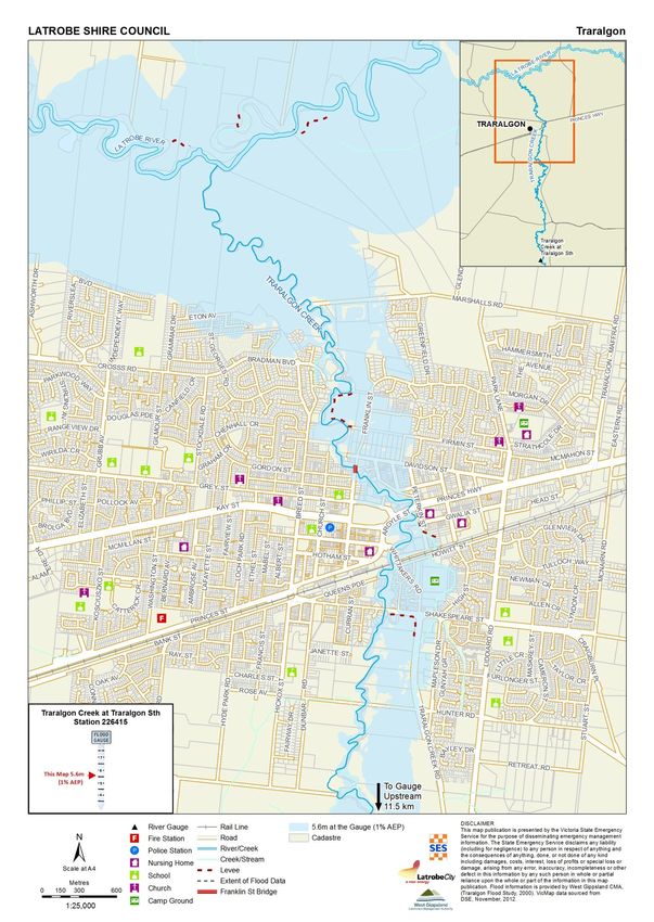
APPENDIX F.07 – MAPS..................................................................................................................... 16
Traralgon Township Map ...................................................................................................................................17
| LATROBE CITY COUNCIL Flood Emergency Plan – A Sub Plan of the MEMP – Version 1.4 August 2013 |
| ATTACHMENT 01 | TRARALGON CREEK | Page 2 of 17 |ASSOCIATED REPORTS
| Traralgon and Rural Surrounds, MEMP Sub Flood Plan, LCC (August 1999)
| Traralgon Creek Flood Forecasting Correlations, BoM (January 2000)
| Traralgon Creek Floodplain Management Study, SKM (November 2000)
| Traralgon and Rural Surrounds, Flood Response Guidelines for the Community, LCC (August 2006)
| Traralgon Creek Flood Warning System, Flood Information Manual, LCC (August 2007)
| Traralgon and Rural Surrounds, MEMP Sub Flood Plan, LCC (August 2007)
| Flood Response Guidelines for the Community, Township and Rural Surrounds, LCC (August 2008)
| State Flood Intelligence Report, VICSES (2012)
ACCURACY & CONFIDENTIALITY
Use this information as a guide to the possible effects of a flood. This card is based on estimates of flood
behaviour and particular effects may occur at heights different from those indicated here. They may also
occur at slightly different heights in different floods. This card may contain sensitive information about the
effects of flooding on private property. Specific reference to private addresses or businesses must be made
directly to owners or other emergency services but not via broadcast or print media.
| LATROBE CITY COUNCIL Flood Emergency Plan – A Sub Plan of the MEMP – Version 1.4 August 2013 |
| ATTACHMENT 01 | TRARALGON CREEK | Page 3 of 17 |APPENDIX A.07 – FLOOD THREATS
OVERVIEW OF RIVER SYSTEM
WEATHER PATTERNS
A slow moving low-pressure system over eastern Victoria and southern New South Wales (commonly referred to
as an East Coast Low) is the weather pattern that normally produces the heaviest rainfall over the catchment
areas of Gippsland, including Traralgon Creek.
At other times, a series of cold fronts produce regular rain events that wet the system, fill on-stream storages and
waterways, at which point a rain event containing normal levels of rain will produce a higher runoff and may
produce flooding.
Severe thunderstorms can also produce heavy rainfall and flash flooding over small areas in addition to the above
weather patterns.
RIVER SYSTEM
Traralgon Creek has a total catchment area of 178km2 and is a tributary of the Latrobe River.
The Traralgon Creek catchment lies on the northern side of the Strzelecki Ranges and drains northwards to the
Latrobe River. From the headwaters to Koornalla (15km), the catchment is narrow with steep sided valleys, is
heavily forested and with little natural flood storage. It has a low infiltration capacity and when combined with
the steep catchment slopes, results in a high rate of runoff.
From Koornalla to the confluence with the Latrobe River (20km) just downstream of the Traralgon township, the
catchment opens out into a valley with gentle slopes and a wide floodplain with large natural storage capacity and
soils that have a greater infiltration capacity.
Most of the runoff is generated in the upper part of the catchment with sharp flood peaks generated which are
attenuated by the floodplain storage on their way to Traralgon. Once the Creek reaches Traralgon, there is a
complex distribution of floodwaters with an ana-branch and minor levees coming into play. More specific
discussion of this is detailed in the Traralgon Flood Plan at Annex C.
FLOOD RISKS
FLOODING FREQUENCY
Traralgon experiences localised flooding within the Township, along rural roads and within rural properties
due to heavy inundations of rainfall throughout the year.
Since 1990 there have been 6 Minor events, nil Moderate events and 7 Major events recorded at Traralgon
township. 75% of all Major flood events on record have occurred in the months May –Sep with June, Jul &
Sep having the highest frequency.
FLASH FLOODING
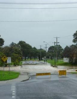
There is a flash flooding risk in the Traralgon Creek catchment, specifically in and around Traralgon and at the
eastern end of the township near the Princes Highway and Liddiard road where houses were inundated during
the 2007 event.
RURAL FLOOD RISK
Throughout the Traralgon Creek catchment there a number of areas that have significant rural flood risk. Though
these areas are not highly populated, rural properties are susceptible to isolation or inundation. Along the creek,
removal of stock and equipment is necessary while some minor roads (eg Jones Road, Traralgon South) may be
closed.
o Traralgon Creek – Koornalla, Traralgon South, downstream of the Traralgon township
| LATROBE CITY COUNCIL Flood Emergency Plan – A Sub Plan of the MEMP – Version 1.4 August 2013 |
| ATTACHMENT 01 | TRARALGON CREEK | Page 4 of 17 |HEALTH & ENVIRONMENTAL RISKS
Industrial areas and residential sheds may contain chemicals; there are also septic tanks in the rural areas
upstream of the town that may be inundated by floodwaters. Gippsland Water operates a sewerage pumping
facility in this area.
PROPERTIES AT RISK
The Traralgon Flood Study (2000) mentions 66 buildings flooded above floor, including 53 residential, and a
further 175 properties flooded, including 157 residential in a 1% AEP riverine flooding event.
HISTORICAL FLOODS
Significant floods have occurred in the Traralgon Creek Catchment as shown in the table below. Only events
post 1988 have been included in the table as there were substantial modifications made to the waterway and
floodway of Traralgon Creek.
with adjusted
(Princes Hwy)
figures from
T R AR AL G O N
T R AR AL G O N
K O O R N AL L A
W r i g h t St
gauge
ST H
EVENT
1989 Oct 2.45 4.55
1993 Sep 4.20 4.85 4.90
1995 Nov 3.85 4.86
2001 Apr 4.20 3.53
2007 Jun 3.38 4.68 4.84
2011 Jul 3.15 4.52 4.54
2012 Jun 3.56 4.89 5.32
2013 Jun 2.40 4.36 4.32
Major - - 4.50
Moderate - - 4.00
Minor - - 3.50
< Minor Minor Moderate Major
SEPTEMBER 1993
The September 1993 flood is the largest recorded gauge height reaching a height of 5.64m at Traralgon
(adjusted to current gauge AHD would be 4.90m. There were substantial river modification works completed
in the 1980’s. During this event 24 residential properties and 3 commercial properties were flooded above
floor. An additional 99 properties were flooded below floor. The estimated total flood damages were $770
000 (HydroTechnology, 1995).
NOVEMBER 1995
The November 1995 flood is the second largest in modern times, reaching a height of 5.60m at Traralgon
(4.86m adjusted height). The flood inundated 24 residences, 3 public buildings and 99 residential allotments,
commercial and public building areas as well as low lying creek frontage farm and recreation land.
JUNE 2012
A detailed summary of the June 2012 event will be included once analysis has been completed.
| LATROBE CITY COUNCIL Flood Emergency Plan – A Sub Plan of the MEMP – Version 1.4 August 2013 |
| ATTACHMENT 01 | TRARALGON CREEK | Page 5 of 17 |MAJOR WATER STORAGES
There are no water storages over 1,000ML within this catchment although Traralgon Railway Reserve / Dead
Horse Canyon needs further assessment.
LEVEES
Name River Location Condition Operator
Peterkin St Levee Traralgon Ck Traralgon Good Latrobe shire
Includes a floodway upstream of Shakespeare St. 100 yr design standard
MAJOR ROAD CLOSURES
Riverine Flooding Flash Flooding
Princes Hwy - @ Grey St, Traralgon Princes Hwy – near Liddiard Rd and further
Highland Hwy – u/s of Traralgon east
RURAL ROAD CLOSURES
SOUTH OF TRARALGON
Riverine Flooding Flash Flooding
Highland Hwy
Traralgon Creek Rd
Jones Road
Downies Lane
Taylors Road
GAUGE LOCATIONS
Gauge Name Location Gauge No.
Zero m
AHD
Traralgon Ck @ Koornalla Approx 1.6km u/s Stoney Ck Junction 86.00 226410
Traralgon Ck @ Traralgon Sth Jones Road 60.00 226415
Traralgon Ck @ Traralgon (Wright St)* @ footbridge, 800m d/s of Princes 29.929* 226023a
Highway Bridge
Traralgon Ck @ Traralgon (Wright St)* @ footbridge, 800m d/s of Princes 31.929* 223023a
Highway Bridge
Traralgon Ck @ Traralgon (Princes @ Princes Hwy bridge 32.673 226023b
Hwy) **
Rain @ Jeeralang Dobbins Road 226829a
Rain @ Balook 85007
Rain @ Mt Tassie 858186 226814
Rain @ Taylors Rd Quarry 85006 - no longer operational
Rain @ Mt Hooghly 85005 - no longer operational
Rain @ Callignee North 85236
Rain @ Koornalla 85281 226410
Rain @ Traralgon Sth 858014
Rain @ Traralgon EPA 85009
* 22 April 1987 - Traralgon Creek @ Wright St gauge was changed which increased the gauge zero from
29.929m AHD to 31.929m AHD.
** August 1998 - Traralgon Creek @Princes Hwy gauge was installed 300m upstream of the Wright St
Footbridge as the Wright St gauge didn’t capture all Traralgon Creek flood flow during large events. This
gauge is utilised for all flood warnings for Traralgon and all data in this document has been adjusted to this
gauge.
| LATROBE CITY COUNCIL Flood Emergency Plan – A Sub Plan of the MEMP – Version 1.4 August 2013 |
| ATTACHMENT 01 | TRARALGON CREEK | Page 6 of 17 |GAUGE LEVEL INFORMATION
Gauge N ame Event Gauge Flow ARI
Height (m) (ML/d) (1 in X years)
Traralgon Ck @ Koornalla 4.50 16,500 100
226410 1993 Sep 4.20 14,200
4.02 12,900 50
1978 Jun 3.89 11,900
1995 Nov 3.85
3.61 9,900 25
2007 Jun 3.38 8,433
2011 Jul 3.15
3.08 6,630 10
2001 Apr 3.03
2005 Feb 2.89
1980 Jun 2.72
2.71 4,610 5
1995 Oct 2.63
2007 Nov 2.58
2011 Apr 2.46
2009 Sep 2.45
1989 Oct 2.43
2012 May 2.37
1978 May 2.37
1984 Jul 2.34
2011 Aug 2.34
2011 Jun 2.33
Traralgon Ck @ Traralgon Sth 2007 Jun 4.68
226415 2011 Jul 4.52
2009 Sep 4.50
2001 Apr 4.20
2005 Feb 4.10
2007 Nov 3.97
2011 Apr 3.81
2011 Aug 3.78
2001 Aug 3.72
2011 Jun 3.70
2007 Jul 3.59
2009 Aug 3.41
2009 Oct 3.13
2010 Sep 2.95
2002 Jul 2.94
1998 Nov 2.92
Traralgon Ck @ Traralgon Wright St 4.20 32,750 500
226023a 5.60 21,170 100
Historical gauge heights are listed below. 5.30 50
4.80 11,840
Traralgon Ck @ Traralgon (Princes Hwy) 226023b ****
Gauge heights listed here include heights from the Traralgon Ck @ Wright St gauge (226023a). These figures have been
adjusted to reflect both the change in AHD in 1987 and the location change to Princes Hwy in 1998.
2012 Jun 5.32 5.32
**** pre adjusted gauge height 1978 Jun 5.01 7.75
1993 Sep 4.90 5.64
1995 Nov 4.86 5.60
2007 Jun 4.84 4.84
2011 Jul 4.54 4.54
Major 4.50
2013 Jun 4.32 4.32
Moderate 4.00
1983 Jul 3.87 6.61
1989 Oct 3.81 4.55
1980 Jun 3.68 6.42
2001 Apr 3.53 3.53
1983 May 3.53 6.27
Minor 3.50
| LATROBE CITY COUNCIL Flood Emergency Plan – A Sub Plan of the MEMP – Version 1.4 August 2013 |
| ATTACHMENT 01 | TRARALGON CREEK | Page 7 of 17 |FLOOD INFORMATION PROVIDERS
Latrobe City Council has identified Flood Information Providers as listed below. These contacts should be
contacted twice per year in March and September.
Location Name Phone
| Traralgon, 5 Atherly Close | Duff, Peter | 5174-8415
| Traralgon, 16 George St | Reidy, Michael | 5174-4367
| Traralgon South, “Glen Gordon” | Symons, Margaret | 5195-5223
| Koornalla, Traralgon Ck Road | Farmer, Charlie | 5195-5263
| Callignee, Symons Road | Symons, H | 5195-5389
| LATROBE CITY COUNCIL Flood Emergency Plan – A Sub Plan of the MEMP – Version 1.4 August 2013 |
| ATTACHMENT 01 | TRARALGON CREEK | Page 8 of 17 |APPENDIX B.01 –FLOOD PEAK TRAVEL TIMES
| Travel times are calculated as the time the peak of the event takes to move from one gauge to the next. Note
the onset of flooding can occur before the peak water level occurs.
| It is possible for flooding to commence at downstream locations prior to peak heights being reached in the
upper parts of the catchment due to both locally heavy rainfall and the backwater effects mentioned earlier.
| Due to the high level of variability in antecedent catchment conditions, flood travel times can vary significantly,
as demonstrated in previous floods.
| Travel times listed here are INDICATIVE ONLY and are HIGHLY VARIABLE.
| Koornalla to Traralgon Sth is in the order of 1-10 hours
| Traralgon Sth to Traralgon Wright St is in the order of 2-12hrs
Gauge Name Jun Jun Oct Sept Nov Jun
1978 1980 1990 1993 1995 2012
| Traralgon Ck @ Koornalla 0 0 0 0 0 0
| Traralgon Ck @ Traralgon 9 hrs 12 hrs 6.5 hrs 2hrs 2.75hrs 7.25hrs
| LATROBE CITY COUNCIL Flood Emergency Plan – A Sub Plan of the MEMP – Version 1.4 August 2013 |
| ATTACHMENT 01 | TRARALGON CREEK | Page 9 of 17 |APPENDIX C.01 – FLOOD EMERGENCY PLAN
TRARALGON
Traralgon Creek @ Traralgon (Princes Hwy)
Minor 3.50m
Moderate 4.00m
Major 4.50m
LOCATION
Traralgon is a major town of approximately 22,000 (ABS Census 2006) residents as well as a regional shopping,
industrial and medical centre for north and east Gippsland residents. It is located near the confluence of
Traralgon Creek and the Latrobe River which lies to the north of the town.
Parts of the existing residential and commercial precincts are located in the creek’s floodplain.
The Princes Highway passes through the town and may be cut during significant floods, which splits the town in
two and cuts all east/west traffic for the duration with no alternative access.
A number of floods have caused extensive damage in Traralgon. In particular the events were in December 1934,
February and August 1951, June 1952, June 1978, September 1993 and November 1995.
FLOOD BEHAVIOUR
Traralgon experiences localised flooding within the township and along rural roads due to heavy inundation of
rainfall, throughout the year. This type of localised flooding causes inconvenience, but is not usually a serious
threat to life or property.
Riverine flooding in Traralgon occurs quickly as a result of heavy rainfall in the catchment of Traralgon Creek
around Mt Tassie and Koornalla. Latrobe River floods do not cause flooding in Traralgon via Traralgon Creek
however they can increase impact by holding up outflows downstream of Traralgon at the confluence (joining)
of Traralgon Creek and Latrobe River.
Traralgon Creek can flood within approximately 6 to 8 hours of start of heavy rain with rapid rises and duration of
12-24hrs (medium floods) and up to 36 hours (large floods). Flooding can occur within town before upstream
gauges have peaked.
| LATROBE CITY COUNCIL Flood Emergency Plan – A Sub Plan of the MEMP – Version 1.4 August 2013 |
| ATTACHMENT 01 | TRARALGON CREEK | TRARALGON | Page 10 of 17You can also read