Mapping oral histories: Augmenting digital audio collections with GIS - Ingenta Connect
←
→
Page content transcription
If your browser does not render page correctly, please read the page content below
https://doi.org/10.2352/issn.2168-3204.2020.1.0.88
                                                                                            ©2020 Society for Imaging Science and Technology

Mapping oral histories: Augmenting digital audio collections
with GIS
Virginia Dressler; Kent State University, Ohio, USA

                                                                         regional hospital personnel, and other persons whose lives were
Abstract                                                                 affected by the events in early 1970 in Kent, Ohio.
     The paper will focus on a project at Kent State University using         The Kent State Shootings Oral History digital collection is
a local oral history digital collection. The project displays the        hosted through the library’s Special Collections and Archives
potential of how the application of an additional layer of geospatial    website (Figure 1). The digital collections are hosted on Omeka [2]
information into an existing digital collection can improve user         (Version 2.5.1), an open-source content management system. The
access and provide alternate methods to browse material                  digital collection provides users with full transcripts and adjoining
(geographically). Transcriptions from the May 4 oral history             audio files from the related May 4 oral history archival subcollection
collection at Kent State University were analyzed and tagged at any      [3]. Users may either search through the digital collection using a
point there was a mention of one of the location points of interest. A   keyword search or use one of the browse categories (narrator name,
new website was created where oral histories could be browsed            role of the narrator or by subject). Visitors to the collection can hear
using a historical map from the time period (spring 1970). This          the oral history through the streaming audio bar within the webpage.
paper will outline the project and provide some initial steps for
other institutions to begin such a project.

Introduction and Background
     The May 4 oral history collection was created in the early
1990s and continues to collect contributions to the collection. The
University Archives began to record personal accounts of the events
leading up to the May 4, 1970 shootings and aftermath from a wide
variety of individuals, mainly from eyewitnesses. The oral histories
display a variety of personal experiences and vantage points from a
singular shared experience and event. Like many other oral history
projects, these recordings are illuminating assets that supplement
and enrich research around the historic event, many ridden with raw           Figure 1. Screenshot of Search and Browse page from the Kent State
emotion and conditional to the role of memory and recollection of             Shootings: Oral History digital collection.
the interviewee.                                                              https://omeka.library.kent.edu/special-collections/kent-state-
                                                                         shootings-oral-histories
     To provide some more context around the event, on May 4,
1970, thirteen students were shot by members of the Ohio National
Guard who had been called in as result of an earlier student
demonstration. Four were killed and nine others were wounded,                  The transcripts are presented to the user through an item level
                                                                         view of a selected oral history file in a separate pop-out HTML page
including one student who was permanently paralyzed. The
                                                                         (Figure 2). The current oral history digital collection website is most
National Guard had been called onto campus after demonstrations
and the burning of the ROTC building on campus, with these events        conducive for researchers who need to find either a known person
taking place May 1-3, 1970. The student demonstrations had been a        or if they have a pre-determined search term(s) to use from the onset
response to the announcement in April 1970 by President Nixon that       of the query. Depending on the nature of the research query, the
                                                                         three existing browse categories may also be useful as well, though
the United States were planning to invade Cambodia.
     The Kent State Shootings Oral History Project collects              the Mapping May 4 project furnishing a different method of
personal accounts of the May 4, 1970, shootings and their aftermath.     navigating an audio-visual collection through the application of geo-
The Special Collections and Archives department at Kent State            spatial information.
University Libraries provides access to both the audio as well as the
transcripts to over 100 oral histories via its digital collections
website. The oral history project was founded in 1990, and current
staff from the department continue to record and receive new
accounts into the Narratives and Commentaries Related to the Kent
State Shootings archival collection [1].
     Many of these recollections are eyewitness accounts from a
wide variety of viewpoints. The narrators of the oral history
accounts are Kent State faculty, alumni, staff, and administrators,
residents of the city of Kent, National Guardsmen, local police,

88                                                                            SOCIETY FOR IMAGING SCIENCE AND TECHNOLOGY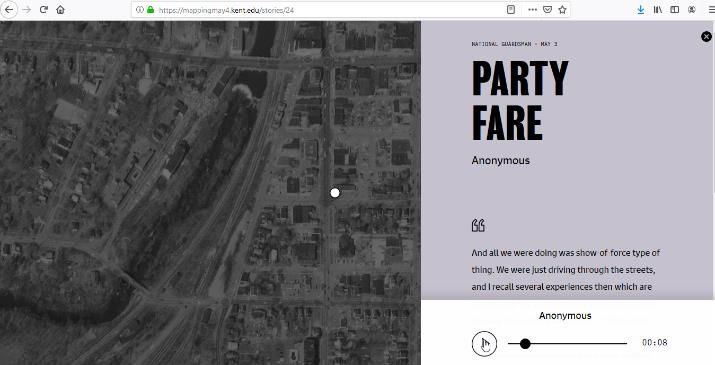
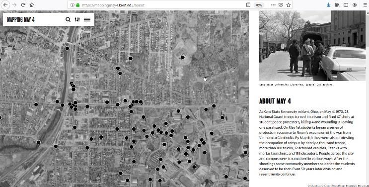
Figure 3.Screenshot of Mapping May 4 website,
                                                                               https://mappingmay4.kent.edu/
Figure 2. Screenshot of oral history transcript,
     https://omeka.library.kent.edu/special-collections/items/show/1829
                                                                                There is also a different method of engagement that is provided
                                                                          to the end user, where oral histories can be explored by a geographic
Project                                                                   browse from the homepage. Figure 5 is a screenshot displaying one
      Researchers from the Department of Geography and the                sample of an oral history. A partial section of the oral history is
Department of Peace and Conflict Studies at Kent State University         highlighted when selected from the map, with an embedded audio
received grant funds to append selected oral history interviews from      player in the lower right corner. If the user is interested in the
the May 4 digital collection with geospatial elements. Funding for        complete oral history, a link is provided to navigate the user to the
the project to date has included: Ohio Humanities grant, Kent State       full oral history on the University Libraries’ digital archive.
50th Commemoration Fund, College of Arts and Sciences at Kent                   The geospatial browse feature is particularly useful and
State, and University Research Council (Kent State University), and       powerful within the May 4th oral history collection, as protests and
has covered the costs associated with the new project website design      demonstrations took place throughout the three days before the
and certain functionalities particular to geo-spatial projects, as well   campus shootings. Many of the oral histories span in time to tell the
as some student work. The student worker assisted in identifying          individual viewpoint and experience about the chain of events
interest points within the oral history files, making detailed notes      around May 4. Provision of a geospatial technique to browse
around each oral history and creating coordinates, as will be             illustrates and serves up the oral history audio files in a different
discussed in more detail below.                                           manner for researchers is central to the project.
      The first phase of the Mapping May 4 project [4] has focused              The site is a custom-built application using MapBox [6] and
on locations outside of the National Historic Landmark area, to           OpenStreetMap [7]. Google Sheets is also used as the central part of
include places that were designated as interest points by the project     the project of data collection and management (Figure 4). Students
team. The National Historic Landmark area, designated in 2016,            have reviewed the oral history audio files and noted where certain
includes seventeen acres of land that is located on the campus of         locations are mentioned. A portion of oral history around place of
Kent State University. Many of the locations selected for the first       interest is selected to provide context. The information captured in
phase are located in the downtown area, as well as other parts of         the shared spreadsheet include: Place name, Hyperlinked Text,
town that sit adjacent to campus.                                         Date, Interviewee name, Interviewee role (student, faculty, National
      The majority of the content from the first phase is from the        Guard, etc), latitude, longitude, and corresponding text excerpt, start
Kent State University Libraries Special Collections and Archives          and stop times in the related audio, filename of the clipped audio
May 4 Oral History collection. Future plans are to also include oral      portion, hyperlink to original oral history digital object,
histories from the Kent Historical Society in the next phase of the       corresponding photograph (optional), photograph caption,
project, as well as the addition of more interest points.                 photograph date, and information about the source of photograph.
      Perhaps the most distinct piece of the Mapping May 4 project
is the geographic browse feature on the new project website that is
not available through the main digital collection archive interface.
On the Mapping May 4 website, a user can explore the oral histories
by location, using the aerial map to navigate. This is particularly
useful if the user is uncertain of a way to search or access the
collection using more traditional methods of keyword search or a
known name of an interviewee, as provided on the University
Libraries digital collection website.

                                                                               Figure 4. Screenshot of the shared Google Sheets form that is used to
                                                                               coordinate the main data input of the project.

                                                                               The process is time consuming to search, identify and isoltae
                                                                          the mention of a single place of interest, create an audio clip of the

ARCHIVING 2020 FINAL PROGRAM AND PROCEEDINGS                                                                                                     89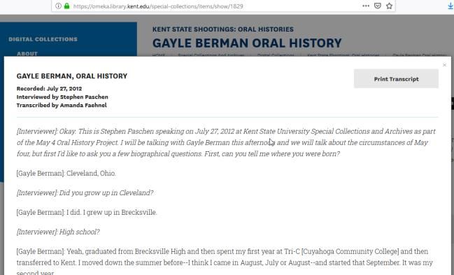
excerpt, associate the location and add into the website (more on this
process in the next section). The result, however, provides an
alternative type of interaction and interface with an audio collection,
adding in another dimension to discoverability. When one of the
interest points is mentioned (such as a building name, street
intersection, or business name) in an oral history, a geospatial
coordinate is noted along with a section of the associated text file.
     Figure 5 displays a sample of one selected oral history. A
historic map is on the left-hand side of the screen providing an idea
of the specific place mentioned in the oral history, and then on the
righthand side of the screen is the selected text from the original
oral history file, as well as an in-browser audio player and link to
the full oral history (hosted on the Kent State University Libraries           Figure 6. Screenshot of Mapping May 4, aerial browsing
digital collections, as outlined above).                                       viewpoint. https://mappingmay4.kent.edu

     Figure 5. A screenshot of a sample item from the project.
     https://mappingmay4.kent.edu/stories/24

      One helpful aspect is that the oral histories were transcribed at
the onset of the project. This was a great help to the project to have
the audio oral history files already in a text format. While the
identification process was still cumbersome, it meant that selected
portions of the oral history were already in text format, allowing           Figure 7. Screenshot of filtering options on Mapping May 4 website.
for easier search capability. The oral histories had been transcribed                          https://mappingmay4.kent.edu
by members of the Special Collections and Archives department
manually, and the accuracy is very high.
      Once a text that mentions one of the selected interest points is         An oral history relies on the recall and memories of the
found, an adjoining audio clip is produced. This is also a time-          indivdual interviewee, oftentimes years or decades after an event(s)
consuming process, but the start and finish times are noted when          has passed. While oral histories can be quite imperfect in nature due
the text is selected to help expediate the process.                       to the shortcomings and fallibility of memory, Frisch stresses the
      Navigating through the Mapping May 4 site provides users            importance of these artifacts to add to a collective historical
with a few options. An aerial historical photograph from the same         memory, one that is “personal and historical, individual and
era at the May 4 shootings is used to provide a pictorial view of the     generational” [5]. Additionally, when there is a collection of oral
selected interest points (Figure 6). In this view, the lower right-       histories centered on one event, researchers can find both the
hand side has been collapsed down. Alternately, there is a way to         commonalities of memories of a particular event (or chain of events)
filter results, based on date, interviewee name and interviewee role      as well as the discord. Supplementing transcriptions with geospatial
(Figure 7). And finally, there is also a basic search function, by        information allows for this intersection to take place in a different
selecting the magnifying glass icon in the upper left-hand side.          manner than the more straightforward user interface that many are
                                                                          accustomed to within many digital collections.

                                                                          Process
                                                                                     Once the locations were decided on, oral history
                                                                          transcriptions were searched to find matching points of reference.
                                                                          When a location is found in an oral history transcription,
                                                                          information was recorded into the project spreadsheet. The fastest
                                                                          way the project team found to record coordinate was to bring up
                                                                          Google Maps. Most of the locations in the first phase are places that
                                                                          are already marked on Google Maps. Once the location is found on

90                                                                            SOCIETY FOR IMAGING SCIENCE AND TECHNOLOGY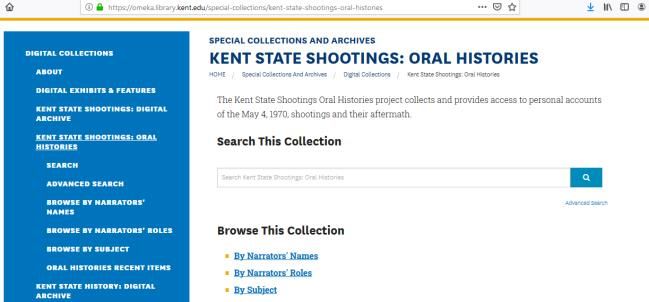
Google Maps, coordinates are provided by right clicking over the         spent on a page is much higher on the Mapping May 4 website rather
location and selecting the “What’s Here” option. Coordinates for the     than the library website May 4 oral history collection (5:08 as
location will appear in a small pop-up box just below the location.      compared to 1:49, comparatively). Further data collection and study
If the desired point is not already identified on Google Maps, it is     will be needed of information around usage to ascertain if the trend
very straightforward to create a new point.                              continues.
           An excerpt of text around the interest point is made to
provide some context for users from each oral history. These
excerpts range in length, from a few sentences to a few paragraphs.      Conclusion
The goal of the excerpt is to provide a story from original oral              The Mapping May 4 website demonstrates a way to augment
history that provides some detail about an experience from the           an existing digital oral history collection through the integration of
selected location.                                                       simple geospatial information. The culmination of the project is
                                                                         presented in a geographically browsable interface, permitting for a
           Next, the student identifies the start and end times of the
                                                                         different mode of discovery and access. New avenues of exploration
selected excerpt and notes them in the project spreadsheet. This
                                                                         are provided to virtually travel through past city streets through the
information is helpful when editing down from the full run audio         imperfect lens of collective human memory.
track. Once the information from the spreadsheet has been reviewed
and approved, it is inputted into the administrative side of the
Mapping May 4 website.
                                                                         References
           Future plans for the site include additional oral histories   [1]   Narratives and Commentaries Related to the Kent State Shootings
from the Kent Historical Society as well as expanding the points of            archival collection, Special Collections and Archives, Kent State
interest to include locations within the historic landmark and other           University Libraries, https://www.library.kent.edu/special-
places in town. The Kent Historical Society recently received a                collections-and-archives/narratives-commentaries-related-kent-state-
small grant in 2019 from the Ohio Historical Records Advisory                  shootings
                                                                         [2]   Omeka, https://omeka.org/
Board to complete transcription on their oral history collection.        [3]   May 4 archival collection list, https://www.library.kent.edu/special-
These files and transcriptions have been shared with the researchers           collections-and-archives/kent-state-shootings-may-4-collection-
from the Mapping May 4 project. This collection is currently housed            contents
on the Ohio Memory website [8].                                          [4]   Mapping May 4, https://mappingmay4.kent.edu/
           The oral history collection from the historical society is    [5]   Michael Frisch, A Shared Authority: Essays on the Craft and
                                                                               Meaning of Oral and Public History, Albany: State University of
not centered around May 4 as the topic, but rather a more broad,               New York Press, pg. 188. (1990).
inclusive collection around regional history. Many of these however      [6]   MapBox, https://www.mapbox.com
touch in part on the topic of May 4, and by and largely represent the    [7]   OpenStreetMap, https://www.openstreetmap.org
local resident perspective. The addition of new oral histories will be   [8]   Ohio Memory, https://ohiomemory.org
a good test to measure how scalable the project is, and provide some
guidance for future digital projects looking to incorporate GIS at our
institution.                                                             Author Biography
                                                                               Virginia Dressler is the Digital Projects Librarian at Kent State
                                                                         University and has worked in academic libraries since 2008 managing
Usage and Analytics                                                      digital initiatives. Her specialty areas are project management of digital
         The Mapping May 4 website launched in the Fall of 2019,         projects and reformatting analog collections for digital collections,
and usage has been tracked using Google Analytics since early            including overseeing the digitization of the daily student newspaper. She
November 2019. The early data collected from this time period            holds an MLIS from Kent State University and an MA in Art Gallery and
(November 2019 to mid April 2020) indicate that the average time         Museum Studies from the University of Leeds.

ARCHIVING 2020 FINAL PROGRAM AND PROCEEDINGS                                                                                                     91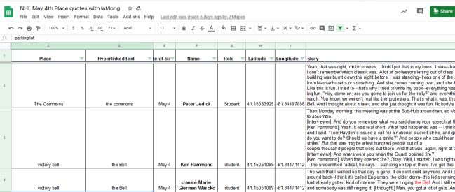
You can also read