Medieval monastic occupation and post-medieval
←
→
Page content transcription
If your browser does not render page correctly, please read the page content below

6. Medieval monastic occupation and post-medieval
military activity at Clare Abbey, Co. Clare
Graham Hull and Sébastien Joubert
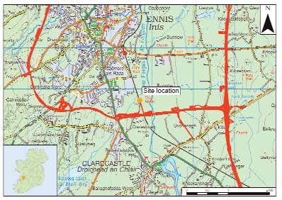
Illus. 1—Location of Clare Abbey, Co. Clare (based on the Ordnance Survey Ireland map).
In August 2005 an excavation was undertaken by Graham Hull, TVAS (Ireland) Ltd, at
Clare Abbey on behalf of Clare County Council and the National Roads Authority as part
of works associated with the N18 Ennis Bypass and the N85 Western Relief Road.1 Clare
County Council requested the construction of a small vehicle turning-space/carpark next
to Clare Abbey, linked to the new N85 by a narrow roadway. This Augustinian abbey,
believed to have been constructed in the 12th century, is located in the townland of
Clareabbey, 2 km south of Ennis and adjacent to the River Fergus (Illus. 1). The buildings
present today consist of a church, domicile and cloister garth, probably remnants of 15th-
century repairs. The abbey is a National Monument (no. 197) in state ownership.
The excavation was located in a triangular plot of land with a linear extension to the
south (Illus. 2). It was bounded on the east by the cloister buildings of the abbey—including
the kitchen and cloister wall—and on the west by the Ennis to Limerick railway. The total
excavation area was 900 m2 and the site was used as a roughly surfaced carpark (Illus. 3)
prior to the excavations.
A miscellany of features was recorded, including wall remnants, ditches, drains, furrows,
pits, post- and stake-holes, and one cess egress hole. The majority of these features relate to
59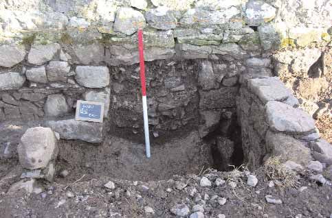
Roads, Rediscovery and Research

Illus. 2—Excavation area adjacent to Clare Abbey (TVAS [Ireland] Ltd).

the monastic activity at the site, but a small number may be associated with military activity
in the region during the turbulent 17th century.

Monastic times

A History of the Diocese of Killaloe (Gwynn & Gleeson 1962, 452) refers to Clare Abbey or
‘The Abbey of SS Peter and Paul’ as an ‘important house of the canons regular of Saint
Augustine . . . founded by King Domnall Mór in 1189 on the banks of the Fergus’. Papal
letters refer to it as de Forgio, a name presumably derived from the river (ibid., 120). The

60
Monastic occupation and military activity at Clare Abbey, Co. Clare

Illus. 3—The roughly surfaced carpark prior to the excavations (TVAS [Ireland] Ltd).

foundation charter of Clare Abbey (1461 copy) indicates that there may have been an
earlier church on the site (Power 2004, 21). Flanagan (2005, 163–74), however, has shown
convincingly that the foundation charter is a 15th-century forgery, written to extend the
Augustinians’ control over other parts of Clare. Westropp (1900, 122) also suggests that an
earlier church existed, but notes that ‘the only suggestion of a pre-Norman building at
Clare may be an early-looking Bullaun in a rounded block of pink granite, and, perhaps, a
carved block over one of the northern windows of the choir’. The limited archaeological
works carried out at Clare Abbey did not reveal any traces of an earlier building, but clearly
identified features associated with the later monastic activity.
    It is suggested that the site for the monastery was chosen because it is surrounded on
three sides by boggy ground subject to flooding by the River Fergus. This marginal setting,
allowing monks to contemplate the divine in isolation, is relatively common for abbeys
(Morris 1989, 111). This tranquil setting was shattered, however, in 1278:

   ‘Mahon, son of Donall Connachtagh O’Brien with his adherents and the O’Gradies,
   billeted themselves at Clare Abbey.Their rest was but short. Soon an alarm was raised,
   and they saw advancing the embroidered standard of Donallbeg O’Brien and the
   crimson coats of his followers. They “agreed that their lives would be longer for
   getting out of his way,” and rushed out of the abbey in the utmost confusion, so “the
   rout of the abbey on Mahon O’Brien” became a proverb in the mouths of clan

                                                                                                 61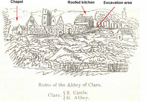
Roads, Rediscovery and Research

Illus. 4—Plan of excavated features adjacent to Clare Abbey (TVAS [Ireland] Ltd).

     Torlough. Unfortunately the matter did not end in honourable battle, but left a stain
     on Donallbeg’s bravery and his followers. They captured many of the “soldiers, fair-
     haired women, little boys, servants, kerne [a medieval Irish foot soldier], horseboys,
     and herdsmen,” making of them “one universal litter of slaughter, butchering both
     prisoners and cattle’ (quoted in Westropp 1900, 120).

   The Ordnance Survey Letters of 1839 refer to McGrath’s Wars of Thomond (c. 1350),
detailing the period between 1194 and 1318, and state that no actual battle was fought but
concur that captives were murdered (Comber 2003, 169). No trace of the battle was
recorded during the archaeological works.
   Clare Abbey’s power and importance grew during the 14th century; the establishment
was seen as one of the most powerful and wealthy monasteries in the country, and remained
so up to the Dissolution (Gwynn & Gleeson 1962).

62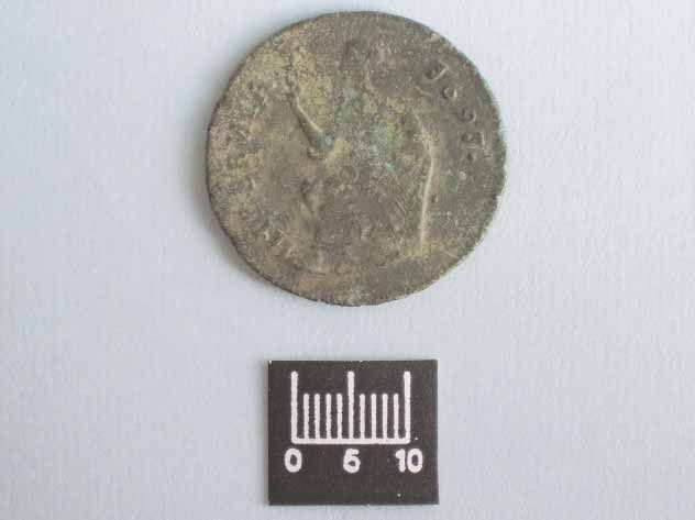
Monastic occupation and military activity at Clare Abbey, Co. Clare

                                                                      Illus. 5—Archaeological
                                                                      features uncovered in the
                                                                      north-eastern part of the
                                                                      site (TVAS [Ireland]
                                                                      Ltd).

Archaeology of the monastic period
The excavation revealed the presence of two gullies running parallel to each other in a
north-east/south-west direction (Illus. 4 & 5). The space between the two gullies,
approximately 5 m, was largely devoid of archaeological features. It is possible that modern
disturbance had destroyed deposits here, but it is also noteworthy that this area corresponds
with a trackway shown on the Ordnance Survey six-inch map of 1840 that led to the abbey
church. Charcoal deposits within the eastern gully have been radiocarbon-dated to AD
1220–1380 (Beta-231533; see Appendix 1 for details). Four large post-holes continued the
line of the eastern gully. The gullies and post-holes are parallel to the west wall of the abbey
cloister. A radiocarbon determination from a pig bone found in one of these post-holes was
dated to AD 1160–1290 (Beta-237218). It is likely, then, that the trackway indicated in 1840
existed in the 13th or 14th century.
    Prior to the excavation, it was noted that a row of holes was let into the outer face of
the west wall of the cloister at ceiling height. These must have been for horizontal timbers,
and it is likely that some of the post-hole alignments seen in the excavated area would have
supported corresponding timber uprights. It is possible to conjecture that in the 13th and
14th centuries there were timber buildings attached to the stonework of the abbey on this
west side. East of the large post-holes were two rows of smaller post/stake-holes. These

                                                                                                  63
Roads, Rediscovery and Research

features were also parallel to the cloister wall and may be internal elements of the timber
buildings constructed against the abbey. At the extreme northern limit of the excavation
area, an insubstantial stone wall, set at 90 degrees to the abbey, was observed. It is possible
that this feature formed part of this extramural building or building group.
    A wall remnant and ditch at the south-west corner of the abbey post-dated the
cloister/kitchen wall and were set at approximate right angles to it. These features may be
the remains of another external building appended onto the main cloistral group of the
abbey (see Illus. 4).
    Six post-holes north of this wall and ditch may also represent timber structures or
possibly scaffolding—perhaps used in the construction of the abbey. A pig bone from one
of these features has been radiocarbon-dated to AD 1200–1280 (Beta-237219).
    Two large pits were recorded adjacent to the abbey. One was a rounded rectangle in plan
and was very precisely cut. The feature measured 2.1 m by 0.8 m and was 0.6 m deep. Over
2,000 eel and fish bones were found in this pit. The River Fergus is famed for its eels, and
the presence of so many bones from a pit that was adjacent to the abbey kitchen reveals that
eel formed a significant element in the diet of the monks in the medieval period. Charred
cereal grain from the ‘eel pit’ has been radiocarbon-dated to AD 1030–1220 (Beta-231531).
As cereal grain is a short-lived organism, this provides a secure date for the pit. The date
range is relatively early as the abbey, according to (admittedly dubious) documentary
evidence, was founded in 1189.
    Two amorphous features were partly excavated, immediately adjacent to the abbey wall
and continuing beneath it (Illus. 5). A piece of Saintonge green-glazed pottery, dating from
the 13th to 14th centuries, was found at the top of the fill of one of these features.
Saintonge ware was imported into Ireland from south-west France as a by-product of the
extensive wine trade. Pig bone from the second feature beneath this west wall has been
radiocarbon-dated to AD 1200–1280 (Beta-237217). A piece of a Ham Green B jug was
recovered from this feature. Ham Green B ware derives from near Bristol and dates from c.
1175–1250. These dates support the documentary evidence for the founding of the abbey
in the late 12th century. The amorphous features may have been stone-holes, as there were
glacial erratics present in the vicinity until modern field clearance, and it could be that some
of these boulders were removed immediately prior to the building of the abbey.
    A single course of foundation stones was recorded beneath the abbey west wall. These
stones rested directly on the natural geology. It was observed, however, that there could be
two different foundation walls, reflecting two different building phases in the abbey west
wall.This would represent two phases of construction or repair of the building, and this may
correspond to the separate construction of the kitchen and the west curtain wall of the
cloister.

Turbulent times

Clare Abbey was dissolved in 1543, and the site and possessions were granted to the
descendants of Domnall Mór, Earl of Thomond and Baron of Inchiquin (Power 2004, 162).
Also at the dissolution, ‘The grantee was pledged to forsake the name “Obrene” [O’Brien],
house the English manners, dress, and language, to keep no kerne or gallow-glasses [an
armed retainer or mercenary, usually of Scottish origin, in the service of an Irish chieftain],

64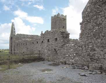
Monastic occupation and military activity at Clare Abbey, Co. Clare

Illus. 6—Thomas Dyneley’s 1681 sketch of Clare Abbey (after Ó Dálaigh 1998, 57).

Illus. 7—Henry Pelham’s watercolour of Clare Abbey c. 1779–82 (after Grose 1793, pl. 8).

obey the king’s laws and answer his writs, to attend the Deputy and succour no traitors’
(quoted in Westropp 1900, 121).
   Thomas Dyneley’s 1681 sketch (Illus. 6) shows that the abbey kitchen had been
converted into a house and also depicts a small chapel adjoined to the abbey, supporting the
notion that religious activity continued up to the later seventeenth century. Post-medieval
agricultural and brick-manufacturing activity detected to the south of the abbey may also
date from this period (Hull & Taylor 2007) but is probably later. The general decline of the

                                                                                                 65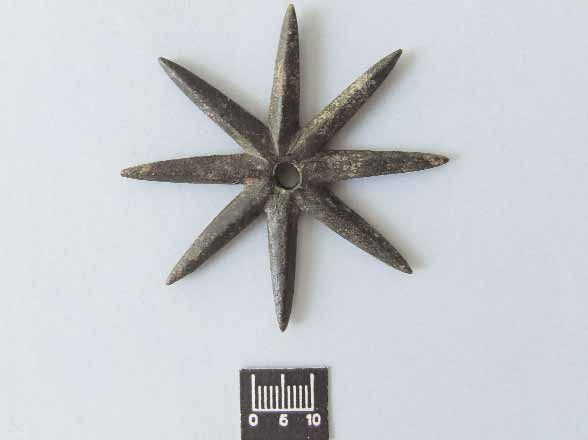
Roads, Rediscovery and Research

abbey is supported by a 1779–82 sketch engraved by Pelham (Grose 1793), which depicts
the kitchen/house as unroofed and the chapel as absent (Illus. 7).

Archaeology of the post-Reformation period
All of the archaeological features on the site were sealed below a substantial layer of
limestone rubble with limestone roofing tile. It is likely that this deposit represents collapse
of the curtain wall and conventual buildings on the west and south sides of the abbey. The
artefacts found in the collapse were generally post-medieval in date and may correspond
with an episode of deliberate destruction.
    The fortunes of the town of Clare (now Clarecastle), just over 1 km to the south,
followed a different path to that of the abbey after the dissolution, as a castle here became
a significant military stronghold during the 1641 rebellion, the Cromwellian conquest and
the 1688–91 Williamite war. Power (2004, 46) refers to a threat made to the properties of
Sir Daniel O’Brien at Clare Abbey and the English settler Gregory Hickman at Barntick.
Hickman was a substantial leaseholder by 1640, leasing 640 acres in Clare Abbey parish at
this time. The arrival of Cromwell’s forces in 1649 led to the invasion of Clare and the siege
of Clare Castle by Ireton in 1651. In the latter stages of the siege there were about 2,000
English soldiers and 1,500 cavalry encamped around Clare Castle (ibid.).
    A cesspit defined by three stone walls abutted the west curtain wall of the cloister and
an opening in the wall was recorded (Illus. 4 & 8). This opening presumably allowed waste
to flow from latrines within the cloister. The cesspit was drained by a pair of linear gullies.
The lower fill of the cesspit was dated to AD 1460–1660 (Beta-233431). At the very base
of the pit, many fragments of high-quality glass from a single vessel were recovered (Illus.
9). The vessel is a beaker, made from very fine clear glass decorated with red, white and
black trails and dates from c. 1600 (E Bourke, pers. comm.). The beaker is likely to come
from the Low Countries and is made in the fashion of Venetian glass (façon de Venise). A very
similar vessel is in the collections of the Museum of Decorative Arts, Prague (Drahotová
1983, 57). Glassware such as this would have been used only by the upper classes at this
period.
    The contents of the cesspit included bone from cattle, pig, sheep, hare, woodmouse,
duck, chicken, goose, woodcock, eel, pike, flounder, frog and also oyster shell (M Holmes,
pers. comm.). These species indicate that the inhabitants of the abbey (be they monks or
post-dissolution occupiers) had a very rich and varied diet. As the cess issued from the
cloister, it is more likely that the cesspit post-dates the Augustinian occupation of the abbey.
There was a break in the foundation stones of the west curtain wall and south range gable
that corresponded with the location of the cesspit and with the eel pit, and it is likely that
stones had been removed from the abbey foundations to allow insertion of these features.
    There is a possibility that some of the archaeological information recorded at Clare
Abbey relates to the wars of the 17th century. Artefactual evidence, in the form of spur parts
(Illus. 10) and a 1691 James II gun-money halfpenny (Illus. 11), struck in the Jacobite-held
city of Limerick, may be related to the historically attested presence of military forces in
the neighbourhood of Clare Castle. Gun-money, or brass money, was issued by James II to
pay for the war and, if victorious, the base metal coinage would have been redeemable for
regular silver currency (Rice 1990). Twenty-eight James II gun-money coins were found in
a hoard at Ballyea, Co. Clare, 6 km south-west of Clare Abbey, in 1982 (Lenihan 1983). The
large body of cavalry that was stationed at Clare in 1691 (Gilbert 1892, 188, 296) would

66
Monastic occupation and military activity at Clare Abbey, Co. Clare
Illus. 8—Cess egress hole cut into cloister
wall (TVAS [Ireland] Ltd).
Illus. 9—Seventeenth-century glass vessel
from cesspit (National Monuments
Service).
67Roads, Rediscovery and Research Illus. 10—Metal rowel from a spur (Arch Con Labs). Illus. 11—1691 James II gun-money halfpenny (Arch Con Labs). 68
Monastic occupation and military activity at Clare Abbey, Co. Clare

have required grazing for their horses and, indeed, Major-General Wauchope wrote a letter
on 18 October 1691, following the capitulation of Limerick, stating that County Clare ‘was
almost the only place we had to subsist the horse and dragoons’ (ibid., 310). The flat pasture
near the castle in Clare and adjacent to a partly roofed institutional structure—the abbey—
would have been ideal.
    Defeat at the Battle of Aughrim in July 1691 led to retreat and the besieging of Jacobite
forces at Limerick. The garrisons at Clare Castle and Ross Castle were strengthened in
order to retain Jacobite control over Clare and Kerry, as well as to defend the areas around
Limerick (Simms 1969, 240). Power (2004, 54) notes that Clare Castle was held by Jacobite
forces under Teige MacNamara of Ayle, Tulla. Conditions at the garrison, even before the
defeat at Aughrim, may have been poor, as evidenced by a complaint dated 28 January 1691:
‘Armed soldiers from Clare Castle were looting around the Latoon district seeking victuals
and terrorising the poor people in their cabins, including women and children’. Colonel
Richards’s diary, written in Limerick at the time of the siege there, notes that on 23
September 1691 a message should be sent ‘to Dominick Sheldon at their horse-camp at
Castle Clare’ (Gilbert 1892, 296), and that on 25 September 1691 ‘Major-general Dominick
Sheldon with the [Catholic] archbishop [of Armagh] and the [Catholic] bishop [of Cashel]
arrived from Clare at the General’s tent’ (ibid., 297). French officers and cavalry were also
based at Clare Castle c. 1691 and, indeed, nearly half the Jacobite cavalry seems to have
been based in County Clare at this time. Article XI of the Treaty of Limerick refers to the
garrison at Clare Castle:

   ‘The garrisons of Clare castle and Ross castle and all the other foot [soldiers] . . . shall
   have the advantage of the present capitulation; and such part of those garrisons as
   deign to go beyond seas, shall march out with their arms, baggage, drums beating,
   ball in mouth, match lighted and colours flying, with all of the provisions and half
   the ammunition that is in the said magazine, and join the horse that march to be
   transported’ (quoted in Gilbert 1892, 304–5).

    Other artefacts found—of various dates—include buckles, horse fittings and a few lead
items, some of which may be window lead (or turned lead). Information about the roofing
of the abbey comes from numerous pegged limestone tiles that probably had a local origin.
A piece of plain-glazed ceramic ridge tile was also found. Such ridge tiles were used on
Anglo-Norman structures in Ireland from the later 13th to the 16th or 17th century (A
Vince, pers. comm.). A clay tobacco-pipe dating from 1660–90 and identical to examples
found in King John’s Castle in Limerick (Sweetman 1980) was found within the collapsed
wall deposits. Small pieces of disarticulated human bone were recovered from a number of
deposits. These finds are unsurprising as the cloister would have been used for Augustinian
burials and possibly later burials too.

Conclusion

As expected, the excavation revealed archaeological features and structures associated with
the Augustinian occupation of the abbey. It was noted that wooden buildings might have
been present against the west curtain wall of the cloister and the gable of the south range.

                                                                                                  69
Roads, Rediscovery and Research
Possible indications of scaffolding used during the construction of the abbey were recorded,
as were post-Reformation occupation layers and features. Considering all the 17th-century
artefacts recovered during the excavation, it is suggested that armies might have camped at
Clare Abbey during the Cromwellian and/or the Williamite wars.
Most of the features will be protected and preserved in situ under the proposed carpark.
The new road to the abbey will allow easier access to the monument, which has always
been remote and fairly unknown to the general public or tourists.With appropriate signage,
the new access road will enhance the heritage of County Clare.
Acknowledgements
Thanks to the field and post-excavation staff of TVAS (Ireland) Ltd, Margaret McNamara
(historical research), specialist contributors, and to Bryan Hamilton and Paul Moroney,
Clare County Council.
Note
1. NGR 134700, 175730; height 6 m OD; excavation reg. nos E2021 & E2022; ministerial
consent no. C020; ministerial direction no. A026/001; RMP no. CL033-120; National
Monument no. 197.
70You can also read