Montane Heath and Thicket of the South West Botanical Province, above approximately 900 m above sea level Eastern Stirling Range Montane Heath ...
←
→
Page content transcription
If your browser does not render page correctly, please read the page content below
Interim Recovery Plan No. 370

Montane Heath and Thicket of the South West
Botanical Province, above approximately 900 m above
sea level
(Eastern Stirling Range Montane Heath and Thicket
Community)

Interim Recovery Plan
2016-2021

October 2016
                                                      1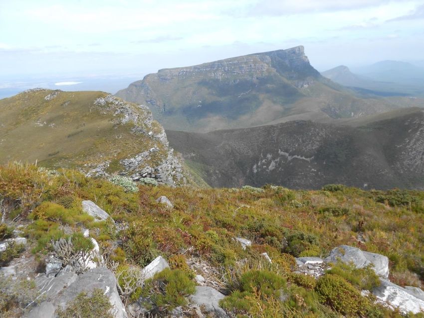
Foreword
Interim Recovery Plans (IRPs) are developed within the framework laid down in Department of Parks and Wildlife Policy
Statement No. 35 (DPaW 2015a) and Department of Parks and Wildlife Corporate Guideline No. 35 (DPaW 2015b).

This Interim Recovery Plan replaces plan number 52 ‘Montane Heath and Thicket of the South West Botanical Province,
above approximately 900 m above sea level (Eastern Stirling Range Montane Heath and Thicket Community) 1999-
2001’ by S. Barrett.

IRPs outline the recovery actions that are required to urgently address the threatening processes most affecting the
ongoing survival of threatened taxa or ecological communities, and begin the recovery process.

The department is committed to ensuring that threatened ecological communities are conserved through the
preparation and implementation of Recovery Plans or Interim Recovery Plans and by ensuring that conservation action
commences as soon as possible and always within one year of endorsement of that rank by the department’s Director
of Science and Conservation.

This IRP will operate from 4 December 2016 but will remain in force until withdrawn or replaced. It is intended that, if
the ecological community is still listed as Threatened after five years, this Interim Recovery Plan will be replaced or
updated.

This IRP was approved by the Director of Science and Conservation on 4 December 2016. The provision of funds
identified in this IRP is dependent on budgetary and other constraints affecting the department, as well as the need to
address other priorities.

Information in this IRP was accurate as at October 2016.

ACKNOWLEDGEMENTS

This plan was prepared by Sarah Barrett. Cover photograph by Sarah Barrett.

The following people provided valuable advice and assistance in the preparation of this Interim Recovery Plan:

Valerie English                  Parks and Wildlife, Species and Communities Branch
Anne Cochrane                    Parks and Wildlife, Science and Conservation Division

CITATION

This Interim Recovery Plan should be cited as:

Department of Parks and Wildlife (2016). Montane Heath and Thicket of the South West Botanical Province, above
approximately 900 m above sea level (Eastern Stirling Range Montane Heath and Thicket Community).
Interim Recovery Plan 2016-2021 for Interim Recovery Plan No. 370. Perth.

                                                                                                                           2
SUMMARY
Name: Montane Heath and Thicket of the South West Botanical Province, above approximately 900 m above sea level
(Eastern Stirling Range Montane Heath and Thicket Community).
Description:
A heathland and dense shrub thicket with a number of endemic species that occupies the high peaks of the eastern
Stirling Range, mountains that are effectively biological islands in a landscape of otherwise low relief. There are five
occurrences of the TEC that cover a total area of about 330 ha. The TEC is found at altitudes of approximately 900 to
1090 m above sea level (a.s.l.) however extending to lower altitudes in two occurrences. Conditions are distinctively
montane; with skeletal soils on quartzite, extremes of temperatures, high humidity and exposure, and occasional
snowfalls. Several endemic and characteristic species within the community and the near absence of Eucalyptus species
differentiate it from other plant communities in the range.
Department of Parks and Wildlife Regions: South Coast
Department of Parks and Wildlife Districts: Albany District.
Local Government Authorities: Gnowangerup.
Conservation status: The community is listed as a critically endangered TEC in WA, endorsed by the WA Minister for
Environment, and listed as endangered under the EPBC Act.
Habitat requirements: This community occurs on shallow soils on quartzite on mountain summits from approximately
750 m above sea level (a.s.l) to 1090 m a.s.l.
Habitat critical to survival: The critical habitat for this community is the montane habitat on which the community
occurs.
The habitat critical to survival is: the area of occupancy of known occurrences; similar habitat adjacent to important
occurrences (i.e. within approximately 200m) and remnant vegetation that surrounds or links several occurrences (this is
to provide habitat for pollinators or to allow them to move between occurrences).
Important occurrences: Occurrences that provide for representation of the community across its geographic range
and that can be managed for conservation and/or with conservation included in their purpose are considered
important occurrences of this community.
Affected interests: All occurrences occur on lands managed by Parks and Wildlife.
Indigenous interests: An Aboriginal Sites Register is kept by the Department of Aboriginal Affairs, and lists one
artifact/scatter site within the vicinity of the occurrences. Actions identify the intention to continue liaison with relevant
groups, including Indigenous groups.
Social and economic impacts and benefits: The implementation of this recovery plan has the potential to have some
social impact in relation to recreational use of the TEC. Recovery actions refer to continued liaison between
stakeholders with regard to these areas.
3Related biodiversity impacts and benefits: Two State-listed Priority Ecological Communities (PECs) (Coyanerup
Wetland Suite and Montane Mallee Thicket of the Stirling Range) benefit from management actions such as disease
and fire controls for this TEC.
Twelve Declared Rare Flora (DRF) are known from the community: Andersonia axilliflora, Banksia brownii, Banksia
montana, Darwinia collina, Darwinia nubigena, Darwinia squarrosa, Daviesia obovata, Deyeuxia drummondii, Lambertia
fairallii, Latrobea colophona, Leucopogon gnaphalioides, Persoonia micranthera and Sphenotoma drummondii; and 21
priority flora taxa also occur in the community. Recovery actions implemented to improve the quality or security of the
community are also likely to improve the status of component species.
Five threatened fauna occur within the TEC: quokka (Setonix brachyurus), Banksia montana mealybug (Pseudococcus
markharveyi), Banksia brownii plant-louse (Trioza barrettae), Robin’s assassin spider (Zephyrarchaea robinsi), Bluff Knoll
Atelomastix millipede (Atelomastix tumula); as well as the priority fauna Bothriembryon glauerti (P2).
Term of plan: The plan will operate from 2016 to 2021 but will remain in force until withdrawn or replaced. It is
intended that after five years, the need for further recovery actions and the need for an updated recovery plan will be
evaluated.
IRP Objective(s): To maintain or improve the overall condition of the ‘Montane heath and thicket’ community and
reduce the level of threat.
Criteria for success
80% or more of the of priority areas covered by this interim recovery plan are maintained at the same
condition rank or improved through actions implemented over the life of the plan, excluding effects of drying
climate that are outside the scope of this plan.
Criteria for failure:
Decline to a lower condition rank of 20% or more of the area of priority areas covered by this interim recovery
plan through inaction or inappropriate actions, excluding effects of drying climate that are outside the scope of
this plan.
Summary of Recovery Actions:
Co-ordinate recovery actions Collect and store seed and other germplasm
Apply phosphite to priority areas Develop and implement restoration strategy
Implement browsing management strategy Protect community from physical trampling damage
Implement rabbit control program Liaise with land managers and relevant Aboriginal
communities
Implement a flora and vegetation monitoring Promote awareness
program to evaluate the effectiveness of disease
and herbivore management
Implement disease hygiene procedures Map critical habitat
Implement fire management strategy Report on recovery plan implementation
Obtain additional ecological information Review plan
41. BACKGROUND
1.1 History, defining characteristics and conservation significance
The unique nature of the ecosystem known as the Eastern Stirling Range Montane Heath and Thicket Community
(referred to as ‘Montane heath and thicket’ from this point forward) was first described by Ludwig Diels in 1906 (Diels
2007), and subsequently in more detail by Pignatti et al. (1993) and most recently by Barrett (1996; 2000). The
threatened ecological community is found at altitudes of approximately 900 to 1090 m above sea level (a.s.l.) however
extending to lower altitudes of ~750m in two occurrences. Conditions are distinctively montane; with skeletal soils on
quartzite, extremes of temperatures, high humidity and exposure, and occasional snowfalls. Several endemic and
characteristic species within the community and the near absence of Eucalyptus species differentiate it from other plant
communities in the Stirling Range.
A characteristic endemic species indicative of its distribution is Andersonia axilliflora, which is or was an abundant and
dominant member of the community. Using A. axilliflora as an indicator, the community extends from the eastern limit
of the Stirling Range, Ellen Peak (1012m), in four more or less continuous occurrences connected by downslope plant
communities, to Coyanarup Peak (1045m) with a separate occurrence on the summit area of Mt Success (750m). The
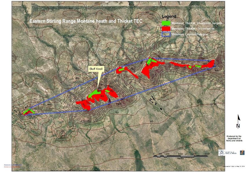
community is geographically restricted and occupies approximately 334 ha over 10 mountain summits (Ellen Peak,
Pyungoorup, Bakers Knob, the Arrows, Isongerup, Moongoongoonderup, East Bluff, Bluff Knoll, Coyanerup and Mt
Success) within a total extent of 644 ha and a lineal extent of 12.5 km (Appendix 1).
The community contains 13 declared rare (Threatened) and 21 Priority flora of which seven are endemic to the
community
Long term monitoring and historical records show that the Montane Heath and Thicket has undergone substantial
decline in recent decades (Keith et al. 2014; Barrett and Yates 2014). Current mapping of the Montane heath and thicket
ecosystem shows that only 48 of 334 ha (14%) of the total historic distribution of the ecosystem remains relatively
intact in terms of species composition (Barrett and Yates 2014).
A suite of fauna depend on the vegetation including two threatened invertebrate species that are dependent on
threatened species in the community.
1.2 Biological and ecological characteristics
Habitat and Floristics
Physical environment
The geology of the Stirling Range is comprised of sandstone and meta-sandstone (quartzite, shale and phyllite)
(Seminiuk 1993). The ‘Montane heath and thicket’ grows on sandy clay loam to peaty clay loam soils with quartz and
quartzite fragments. These soils are generally acidic (pH < 5) and have macro-nutrient and organic carbon
concentrations that are high relative to the typically nutrient poor soils of the surrounding lowland plains (Barrett 2001).
Plant growth is limited by low temperatures and high wind speeds that prevail for much of the year (Barrett 1996). The
Stirling Range runs in an east-west direction and intercepts prevailing southerly winds from the Southern Ocean
resulting in low-level stratified clouds draping over peaks on many days of the year. Long term climate data are not
available for the ecosystem, but mean annual precipitation is estimated to be greater than 1000 mm (Courtney 1993).
Although humidity is high for much of the year, the ecosystem is prone to fires spreading from the plains below during
warmer, drier summer months (Barrett & Yates 2014).
5Biological environment
The ecosystem was described by Barrett (2000) as ‘Montane heath and thicket’ following Muir’s Structural Classification
(1977). The ‘Montane heath and thicket’ varies in height (from 0.5 to 2m) and cover (Projected Foliage Cover up to 80%)
depending on abiotic factors including soil depth, aspect and fire as well as biotic factors such as disease and grazing.
Taller thicket vegetation occurs on more sheltered sites on deeper soils. Characteristic plant taxa belong to the families
Proteaceae, Myrtaceae, Fabaceae, Ericaceae, Apiaceae and Cyperaceae (Barrett and Yates 2014) (Appendix 2).
Descriptions of the vegetation are found in Barrett (1996; 2000). The upper shrub stratum is characterised by
Andersonia axilliflora (a key endemic species), Kunzea montana, Beaufortia anisandra, Calothamnus montanus, Hakea
florida, Banksia oreophila, B. solandri, B concinna, and Sphenotoma sp. Stirling Range and the lower sedge layer by
Lepidosperma sp. Bluff Knoll robust, Desmocladus flexuosa and Tetraria sp. Jarrah Forest. Annual and perennial
graminoids and herbs are most abundant in the first five years after fire and then decline as the dominant shrub
overstorey develops (Keith et al. 2014).
A range of proteaceous species were, or are, structurally significant and include Banksia brownii, B. montana, B.
concinna, B. oreophila, B. solandri and Hakea florida. Eucalyptus species are notable for their absence from the
community but occur at immediately lower altitudes. Species endemic to the community are A. axilliflora, Banksia
montana, Persoonia micranthera, Darwinia collina, Microcorys sp. Stirling Range, Stylidium sp. Bluff Knoll and Stylidium
keigheryi.
Hydrology
There are no data available on surface or sub-surface water characteristics of the ‘Montane heath and thicket’ TEC.
Related biodiversity impacts and benefits
Other TECs, Threatened and Priority flora and Threatened fauna either occur in the remnant vegetation containing this
community or directly adjacent and may benefit from recovery actions implemented to improve the quality of the
community.
Priority Ecological Communities (PECs) immediately adjacent to the ‘Montane heath and thicket’ TEC are
‘Montane mallee thicket of the Stirling Range’ (P1) and ‘Coyanerup wetland suite’ (P1).
A list of the 13 Threatened flora and 21 Priority taxa that occur with the community is presented in Table 1.
Table 1: Threatened and priority flora that occur in the ‘Montane heath and thicket’ TEC
*= endemic to TEC
Species name WA Conservation status Conservation status
and rank (EPBC Act 1999)
Andersonia axilliflora T* (CR) EN
Banksia brownii T (CR) EN
Banksia montana T* (CR) EN
Darwinia collina T* (CR) EN
Darwinia nubigena T (EN) VU
Darwinia squarrosa T (VU) VU
Daviesia obovata T (EN) EN
Deyeuxia drummondii T (VU) EN
Lambertia fairallii T (CR) EN
6Latrobea colophona T (CR) -
Leucopogon gnaphalioides T (CR) EN
Persoonia micranthera T* (CR) EN
Sphenotoma drummondii T (EN) EN
Dielsiodoxa tamariscinus P2
Gastrolobium leakeanum P2
Microcorys sp. Stirling Range P2*
Platysace sp. Stirling Range P2
Schoenus sp. Stirling P2
Spyridium montanum P2
Stylidium bellum P2
Stylidium keigheryi P2*
Stylidium oreophilum P2
Stylidium rosulatum P2
Stylidium sp. Bluff Knoll P2*
Adenanthos filifolius P3
Andersonia echinocephala P3
Hibbertia aff. argentea P3
Hypocalymma myrtifolium P3
Sphenotoma sp. Stirling Range P3
Actinotus rhomboideus P4
Banksia concinna P4
Banksia solandri P4
Boronia crenulata var. P4
angustifolia
Muiriantha hassellii P4
Fauna
One threatened vertebrate fauna occurs within the TEC: quokka (Setonix brachyurus).
Invertebrate fauna
The Stirling Range is notable for the prevalence of short range endemic and relictual invertebrate species (Harvey 2002;
Moir et al. 2009; 2010, 2011, Rix and Harvey 2012). Within the ‘Montane heath and thicket’, are a number of endemic
species of spiders, snails and millipedes. Threatened invertebrate fauna that occur within the TEC are: Banksia montana
mealybug (Pseudococcus markharveyi), Banksia brownii plant-louse (Trioza barrettae), Robin’s assassin spider
(Zephyrarchaea robinsi), Bluff Knoll Atelomastix millipede (Atelomastix tumula), as well as the Priority 2 species
Bothriembryon glauerti.
As part of a project to determine the co-extinction potential of plant-dwelling insects, mealybugs were collected on the
foliage of Banksia montana (Proteaceae) in the Montane heath and thicket TEC. Pseudococcus markharveyi was
discovered in 2007 through this targeted sampling of threatened plant species and non-threatened congenerics. The
host-specific and Critically Endangered hemipterans (the Banksia brownii plant-louse and the Banksia montana
mealybug), are known to be dependent on B. brownii and B. montana plants, respectively, within the TEC for their life
cycle. They feed exclusively on the sap of these plants; however, both hosts and dependent fauna are at risk of co-
extinction (Moir et al. 2012; Gullan et al. 2013; Taylor & Moir 2014; Moir et al. 2016).
7Microsatellites of the Banksia brownii plant-louse and B. brownii show high evolutionary congruency between plant and
insect populations in Stirling Range and Albany Coastal populations (Moir et al. 2016). The extinction of divergent B.
brownii populations within the TEC, therefore, is likely to have resulted in the extinction of divergent plant-louse
populations. Up to half of the genetic diversity of Banksia brownii populations has been lost following the extinction of
B. brownii along the eastern massif of the Stirling Range (Coates et al. 2015). Given the high degree of congruence
between plant and plant-louse populations, the extinction of these eastern massif B. brownii populations by 2000 may
have also resulted in the extinction of a very significant component of the divergent plant-louse population (Moir et al.
2016).
The Endangered plant Leucopogon gnaphalioides, another member of the TEC, has been found to host a distinctive
assemblage of insects, despite other species of Leucopogon and members from the same plant family (Ericaceae) being
found in close proximity. Leucopogon gnaphalioides’ distinctive insect assemblage provide an example of a largely
undescribed fauna (Moir & Vesk 2012).
Habitat critical to survival, and important occurrences
The habitat critical to survival is: the area of occupancy of known occurrences; similar habitat adjacent to important
occurrences (i.e. within approximately 200m) and remnant vegetation that surrounds or links several occurrences (this is
to provide habitat for pollinators or to allow them to move between occurrences). Occurrences considered to be of
highest importance are Bluff Knoll, Isongerup, East Bluff, Pyungoorup, Bakers Knob, Moongoongoonderup, Mt Success
and Coyanerup.
1.5 International Obligations
This plan is fully consistent with the aims and recommendations of the Convention on Biological Diversity, ratified by
Australia in June 1993, and will assist in implementing Australia’s responsibilities under that convention. This
community is not listed under any specific international treaty, however, and therefore this interim recovery plan (IRP)
does not affect Australia’s obligations under any other international agreements.
1.6 Indigenous interests
A search of the Department of Aboriginal Affairs (DAA) Aboriginal Heritage Sites Register revealed one site of
Aboriginal significance in or adjacent to the TEC. This site is listed in the table below. The TEC also within the Stirling
Range National Park is known to be a culturally significant site to Aboriginal people. Input and involvement has been
sought through the South West Aboriginal Land and Sea Council (SWALSC) and DAA to determine if there are any
issues or interests with respect to management of the TEC in the vicinity of these sites. Indigenous opportunity for
future involvement in the implementation of the plan is included as an action in the plan. Aboriginal involvement in
management of land covered by an agreement under the Conservation and Land Management Act 1984 is also
provided for under the joint management arrangements in that Act, and will apply if an agreement is established over
any reserved lands in which this TEC occurs.
Table 2. Aboriginal site registered with Aboriginal Affairs
Site identification Access Restriction Site name Site type
5145 open none Kojaneerup Artefacts
1.7 Social and economic impacts and benefits
8The implementation of this recovery plan has the potential to have some social and economic impact, where
occurrences are used for recreational purposes. Recovery actions refer to continued liaison between stakeholders with
regard to these areas.
1.8 Affected interests
Occurrences occur within the Shire of Gnowangerup on Parks and Wildlife managed land (Stirling Range National Park).
1.9 Term of plan
The plan will operate from 2016 to 2021 but will remain in force until withdrawn or replaced. It is intended that after
five years, the need for further recovery actions and the need for an updated recovery plan will be evaluated.
1.10 Strategies for recovery
To identify, and influence the management of the areas in which the community occurs, so maintaining natural
biological and non-biological attributes of the sites and the current area covered by the community.
To conduct appropriate research into the ecological characteristics of the community to develop further understanding
about the management actions required to maintain or improve its condition.
2. THREATENING PROCESSES
Phytophthora dieback.
The most significant threat to the TEC is Phytophthora dieback resulting from the plant pathogen Phytophthora
cinnamomi (Wills 1993; Barrett 1996; 2000; Barrett et al. 2008). The pathogen has spread to many of the peaks through
the transport of infested soil. This has occurred largely through foot access since 1974, when P. cinnamomi was first
noted in the Stirling Range National Park by CSIRO researchers (Grant and Barrett 2003). Infestations high in the
landscape have led to considerable down-slope spread in broad fronts with extensive infestation of the thicket. The
pathogen thrives in the humid montane conditions, susceptible vegetation and conducive soils. The entire extent of the
eastern Stirling Range has been infested by P. cinnamomi to at least some degree, but small pockets of the TEC remain
dieback-free or less extensively infested. These specific areas (priority areas) on Pyungoorup, Bakers Knob, Isongerup,
west Moongoongoonderup, East Bluff, Bluff Knoll, Coyanerup and Mt Success, where the community persists relatively
intact, were mapped following ground based survey in the early 2000s.
Many characteristic species in the TEC are either susceptible or highly susceptible to the pathogen (Barrett et al. 2008;
Shearer et al. 2013). These include Banksia solandri, Banksia montana, Banksia concinna, Banksia oreophila, Lambertia
uniflora, Andersonia axilliflora, Andersonia echinocephala, Leucopogon gnaphalioides, Latrobea colophona, Isopogon
latifolius; Darwinia collina, Persoonia micranthera and Gastrolobium leakeanum. For many of these species, samples
taken from stressed plants in the ecosystem have returned positive (Barrett 1996).
Changes are most evident in the decline of species of Proteaceae that were dominant in the thicket (Keith et al. 2014).
Photography from the 1960s to the 1980s records healthy stands of B. montana, B. brownii and Isopogon latifolius on
the summit of Bluff Knoll. Monitoring since 1994 has shown these species to be locally extinct, or as in the case of B.
montana, extremely rare.
9Long term monitoring of P. cinnamomi susceptible defining species of the ‘Montane heath and thicket’ in the last two
decades has shown a 35% decline in the number of populations of these species (Barrett & Yates 2014). The severity of
this decline is further emphasized where long term monitoring of plants in individual populations has been undertaken
showing a mean decline of 83% in the number of plants within populations. Population extinctions have been recorded
for eight species from the TEC (Barrett & Yates 2014).
Aerial spraying of the fungicide phosphite to increase resistance of susceptible species to infection by P. cinnamomi
began in 1997. Some 52 ha are sprayed annually to biennially at 12-24 kg/ha in eight targets (Appendix 1). The
effectiveness of disease control has shown some variability between and within sites and with season. The reasons for
this variability are not well understood and there has only been limited sampling of in-planta phosphite levels due to
costs and access to analysis. There has been only limited use of controls to compare survival of susceptible species in
sprayed and non-sprayed habitat (Barrett 2003). The abundance and diversity of susceptible species remains higher
within long-term sprayed targets compared with non-sprayed areas although this has not been well quantified. Overall,
the decline of susceptible obligate seeding species has been slowed by phosphite application (Keith et al. 2014) and
this has ‘bought time’ for other conservation measures including ex-situ conservation.
Inappropriate fire regimes
Inappropriate fire regimes are another major threat to the community. Most of the component species are killed by fire
relying on seeds to regenerate. As a consequence, fire intervals are particularly important for the dynamics and
persistence of the community. Major fires occurred in the thicket in February 1972, April 1991 and most recently in
November 2000. Some patches were burnt by one, two or all three of the fires with a trend to more extensive and
intensive fires over time (Barrett & Yates 2014).
In the ‘Montane heath and thicket’ TEC 71% of species are non-resprouters and of these 22% are serotinous (Barrett et
al. 2009) rendering the community highly vulnerable to fire interval-dependant effects. For non-resprouting species,
minimum fire intervals may be defined by a reproductive threshold at which the 50% of the population has reached
reproductive maturity (Burrows et al. 2008; Gosper et al. 2013). For the ‘Montane heath and thicket’, the minimum time
to at least 50% reproduction varies between 5 and 13 years for common and threatened non-resprouting species
(Barrett &Yates 2014).
Approximately 5% of the ecosystem has remained unburnt since at least 1972, 2% was last burnt in 1991, 74% was
burnt in both 2000 and 1991, and 19% was burnt in 2000 but not 1991. As a consequence, a large proportion (74%) of
the ecosystem has experienced a fire interval (9 years) at the lower bounds of risk for species persistence (Yates &
Barrett 2014).
The TEC is still in the early stages of recovery and is therefore highly susceptible to fire returning in the near future.
Measurements of growth for a dominant overstorey species, Kunzea montana, indicate that it may take at least 30 years
for the community to recover maximum height structure following fire (Keith et al. 2014).
Fire may also interact with P. cinnamomi to increase disease impact and accelerate the collapse of obligate seeding
populations of Proteaceae (Moore et al. 2015). The species most susceptible to fire-related decline (serotinous non-
sprouting species in Proteaceae) are coincidentally the species most susceptible to the pathogen (Barrett & Yates
2014). Estimates of the density of this group of species in the four fire histories where the pathogen is present show
they are most abundant in areas that have not been burnt since at least 1972 and lowest in areas that have experienced
the most fire (Barrett & Yates 2014). Minimal recruitment of serotinous Proteaceae occurred in areas burnt in 1991 and
2000.
Recruitment of proteaceous species was particularly poor after the 2000 fire, even in areas that had not burnt in 1991. It
is unclear whether this was due to season of the fire (spring), herbivory or disease impact as individuals of plants such
as Banksia montana held adequate seed banks at the time of the fire.
10Grazing / Browsing
Montane ecosystems are vulnerable to the removal of vegetation cover through grazing or browsing by feral or native
vertebrate fauna (Leigh et al. 1987; Bridle & Kirkpatrick 1999; Bridle et al. 2001). Since the original IRP for this TEC was
completed in 1999 and specifically after the 2000 fire, the impact of browsing by vertebrate fauna has become
increasingly apparent. Significant investment has been made in conservation actions for the ‘Montane heath and
thicket’ TEC. These included threat mitigation e.g. application of the fungicide phosphite to mitigate Phytophthora
dieback or ex-situ conservation strategies i.e. germplasm storage and translocations. It is critical that extant populations
of key target species reach maturity and produce flowers and viable seed. Consequently, integrated management that
addresses threats of browsing in combination with management of dieback and fire is vital in this ecosystem (Rathbone
et al. 2016a).
Survey since 1994 had confirmed the presence of the herbivorous feral rabbit (Oryctolagus cuniculus) and native
quokka (Setonix brachyurus) within the TEC (Barrett 1996). Rabbit control using 1080 oats was trialed in 2001 on Bluff
Knoll, East Bluff and Pyungoorup (Blechynden 2001). Hand-laying of 1080 oats was implemented annually to tri-
annually, depending on resources, from 2008 to 2015 (Pyungoorup baited only twice for logistical reasons). From 2001,
plant cages were used to protect selected threatened flora (B. montana, P. micranthera, A. axilliflora, L. gnaphalioides, D.
collina, L. colophona). This was associated with a significant recovery (Rathbone & Spencer. 2011).
Between 2011-2015, motion sensing cameras (Reconyx PC900) were used intermittently to identify vertebrate
herbivores responsible for browsing of native vegetation, targeting areas with high browsing impacts and where
threatened flora was present (Rathbone et al. 2016a). A total of 304 camera days of footage captured 96 events
triggered by seven mammalian fauna. Quokka was the only strictly herbivorous native species recorded and was
responsible for 75% of the events. Quokka was also captured directly browsing on three threatened species (Andersonia
axilliflora, Latrobea colophona and Leucopogon gnaphalioides). All other native species observed were carnivorous,
omnivorous or nectivorous: mardo (Antechinus flavipes), bush rat (Rattus fuscipes), quenda (Isoodon obesulus) and
honey possum (Tarsipes rostratus). Two feral species were infrequently observed (the herbivorous rabbit (Oryctolagus
cuniculus) and the carnivorous feral cat (Felis catus)).
Dietary analysis in 2015, through faecal examination of quokka and rabbit scats, revealed contrasting diets and
implicates native rather than feral species as responsible for impacts on dicotyledonous species, and in particular those
of conservation significance, including the threatened Darwinia collina (Rathbone et al. 2016a). In contrast, rabbit diet
was largely comprised of monocot species.
Ten fenced exclosures (approximately 25 x 25m) were constructed between 2014-2015 (Rathbone et al. 2016a). The
exclosures were located in sites that were completely or partially burnt by wildfire in 2000 and were chosen to protect
focal areas of the TEC that contained high densities of threatened flora. Exclosure experiments conducted over 1-2
years revealed significant changes in abundance, cover and height of perennial herbs and importantly, an increase in
growth and reproduction of four threatened endemic plants.
Detrimental impacts caused by native browsing fauna are not unprecedented and suggest disequilibrium in normal
ecosystem process, potentially due to multiple interacting threats. Montane ecosystems may be particularly vulnerable
to browsing due to their naturally slow recovery after disturbance.
In addition, browsing by quokka, as well as grazing by rabbit, reduces cover and increases soil exposure thereby
creating environmental conditions more conducive to plant disease. For plant species with critically low population
numbers, the impact of browsing poses a threat to population persistence and undermines investment in other
conservation recovery actions (Rathbone et al. 2016a).
Disturbance from recreational activities
11The higher peaks of the eastern Stirling Range attract visitors interested in bushwalking, nature observation and rock-
climbing. Bluff Knoll is the most popular site visited, being the highest mountain in the southwest. The Ridge Walk from
Ellen Peak to Bluff Knoll is a popular walk that is well known by bushwalkers throughout Australia. It takes between two
and three days to complete, and preferred camping places include the Arrows and Bakers Knob. The walk is described
in bushwalking guides by Morphett (1996) and Rankin (1989).
The Ridge Walk has implications for areas of the TEC that contain a relatively intact community as it traverses several of
these remnants. Negative impacts that result from recreational activity include braiding of tracks, erosion, bare-ground
occurrences, camp-fire remains, litter and nutrient enrichment of soils and introduction or spread of different isolates of
P. cinnamomi.
Braiding of paths along the Ridge Walk has occurred in a number of places within the TEC, particularly on Bluff Knoll
and East Bluff. Sections of the Ridge Walk have been marked, realigned and brushed to minimise any impacts on
priority areas of the community. Side paths have formed on the summit of Bluff Knoll where people have explored or
accessed viewing points. The paths in the montane community are particularly at risk of track erosion where they run
across the contour lines, due to erodible soils and steep inclines.
There are scattered bare ground occurrences and fire places along the ridge walk. These impacts tend to be
concentrated in saddle areas adjacent to the TEC but impacts also occur within the TEC on ridge-lines and summit
areas.
Litter levels generally correlate with the level of visitor use and are greatest on Bluff Knoll. Although biodegradable,
toilet paper on the mountains, and particularly on Bluff Knoll, has a significant visual impact. High visitor numbers may
also result in increases in soil fertility and weed invasion associated with accumulation of human excreta on the peaks.
In South Australia, herbs (weeds in particular), and sedges were favoured by even minor increases in soil fertility in soils
that were originally nutrient poor (Specht 1963). The impact of increases in soil fertility on composition of the TEC has
not been monitored to date, it is considered that impacts are likely to be localised at present.
The major implication of past recreational activity for the Eastern Stirling Range Montane Heath and Thicket
Community has been the spread of P. cinnamomi (Gillen & Watson 1993; Wills 1993). It is apparent that the pathogen
has spread to many of the peaks through the transport of infected soil, mostly by foot access, as a result of both
recreational and other activities. There is also the potential for spread of the pathogen by fauna movement.
The current implications of recreational soil vectoring are the spread of the pathogen to small disease-free pockets or
the introduction of new isolates of P. cinnamomi (Bryan Shearer pers. comm.). Path drainage is important in relation to
both erosion and the risk of spreading dieback (Watson & Passmore 1993). In wet conditions pooling of water occurs
near the summit areas of Bluff Knoll. These wet areas provide ideal sites for the transfer of Phytophthora through soil
collected on walking boots (Gillen & Watson 1993). Moist soil conditions prevail for much of the year on the higher
peaks, particularly near mountain summits associated with run-off from rock faces.
Climate change
Climate change as a threatening process is outside the scope of this interim recovery plan and the temperature and the
rainfall thresholds for individual species persistence are unknown. There has been only limited collection of climatic
data for the TEC. However, as this community occupies mountain tops there is literally nowhere for many vulnerable
species to migrate to.
The consensus among global climate models is that temperature will increase and rainfall will continue to decline in
south west WA with associated increase in wildfire risk. The potential for fire intervals below the tolerance threshold for
this community is likely to increase (Barrett & Yates 2014).
12Projected increases in temperature may also negatively affect the persistence of component species. Investigations of
temperature and seed germination for selected species from the ‘Montane heath and thicket’ show a negative
relationship between increasing mean temperature and germination for some species (Cochrane et al. 2011).
3. GUIDE FOR DECISION-MAKERS
Any on-ground works (significant clearing, burns, proposals with potential to alter drainage or water quality) within or
in the vicinity of TEC will require environmental impact assessment. Proponents should demonstrate that on-ground
works will not have a significant impact on the TEC. These include:
proposals that will result in a significant increase in fire frequency;
proposals that will exacerbate known threatening processes including Phytophthora dieback and browsing;
proposals that cause a significant increase in opportunity for physical damage through trampling of vegetation.
134. CONSERVATION STATUS
The TEC was endorsed by the WA Minister for Environment in 2001 as Critically Endangered and was listed as an
Endangered threatened ecological community (TEC) under the Commonwealth Environment Protection and Biodiversity
Conservation Act 1999 (EPBC Act) in July 2000.
5. RECOVERY OBJECTIVES AND CRITERIA
5.1. Objectives
To conserve the ecological and conservation values of the ‘Montane heath and thicket’ TEC by:
Maintaining or improving the overall condition of the community.
Reducing the level of threat to the community.
5.2 Criteria for success:
80% or more of the area of priority areas covered by this interim recovery plan are maintained in the same
condition rank or improved through actions implemented over the life of the plan, excluding effects of drying
climate that are outside the scope of this plan.
5.3 Criteria for failure:
Decline to a lower condition rank of 20% or more of the area of priority areas covered by this interim recovery
plan through inaction or inappropriate actions, excluding effects of drying climate that are outside the scope of
this plan.
146. RECOVERY ACTIONS
The responsible authority is frequently listed as the relevant Parks and Wildlife District. This refers largely to initiating
and guiding actions. However, in general the relevant Parks and Wildlife District, in liaison with the Species and
Communities Branch and the relevant Recovery Team share the primary responsibility for securing funds for, and/or
coordinating the implementation of, recovery actions.
6.1. Existing recovery actions
Significant recovery actions have been completed for the community:
The extent and boundaries of all known occurrences have been mapped.
Dieback-free areas and areas where the community persists relatively intact (priority areas) were mapped following
ground based survey in the early 2000s.
Threats for areas currently dieback-free or relatively intact have been evaluated.
Areas of the community have been ranked in terms of relative urgency for recovery actions and key recovery
actions identified.
Threatening processes have been managed for the identified priority areas:
Aerial phosphite spraying was initiated in 1997, since then the following eight targets have been sprayed
regularly on an annual to biennial basis; Bluff Knoll (16ha), East Bluff (3ha), Isongerup (13ha), Pyungoorup (3ha),
Bakers Knob (2ha), Moongoongoonderup (5ha) Coyanerup (1ha) (from 2005), Mt Success (9ha) (Appendix 1).
Prior to the 2000 fire, sites were sprayed at 24 kg/ha biennially. After the 2000 fire, spraying resumed in 2002 at
a lower rate of 6-12 kg/ha, with annual to biennial spraying of 52ha at 12 kg/ha since 2008.
Flora monitoring has been undertaken to monitor the survival of susceptible (mainly threatened) species and to
evaluate the effectiveness of phosphite application (Barrett 2003, Keith et al. 2014; Barrett & Yates 2014).
A long-term research program investigating the fire ecology of the eastern Stirling Range ‘Montane heath and
thicket’ Community was initiated in 2001 and a paper and book chapter published (Barrett and Yates 2014; Keith et
al. 2014).
Research into dieback-fire interactions has been undertaken within the adjacent ‘Montane mallee thicket’ PEC and
a paper published (Moore et al. 2014)
A paper on extinction risks for several plant species within the TEC threatened by Phytophthora cinnamomi was
presented at the 2007 MedEcos Conference and published in 2008 (Barrett et al. 2008).
A fire management strategy (Barrett et al. 2010) has been developed for the Stirling Range National Park and the
TEC identified as a fire exclusion zone until the community has recovered sufficiently from the 2000 wildfire.
A rabbit control strategy has been implemented since 2008 with baiting annually to triannually mainly on Bluff
Knoll and East Bluff, with Pyungoorup baited twice.
Multiple seed collections have been made from threatened, priority and keystone species from the TEC and are
currently being stored in the department's Threatened Flora Seed Centre at –18C.
Material for tissue culture has been collected and techniques for propagation are being developed (e.g. for Banksia
montana) by Botanic Gardens and Parks Authority (BGPA).
Remote sensing cameras were used 2011-2015 to determine the source of grazing impacts for individual species;
rabbit and quokka scats were analysed in 2015 to determine what plant material was present.
Remote sensing cameras were used in 2015 to assess pollinators for the endemic species Banksia montana.
Individual Threatened flora (B. montana, P. micranthera, L. gnaphalioides, L. colophona, D. collina, A. axilliflora)
plants within the TEC were fenced from 2001 to reduce grazing impacts (Rathbone & Spencer 2011). Larger fenced
enclosures to protect the TEC were constructed on Bluff Knoll, Coyanerup and East Bluff in 2014-2015 and detailed
monitoring established (Rathbone et al. 2016a).
15 A trial of small-scale restoration planting of Banksia oreophila seedlings, a keystone species, was implemented in
2010 (Rathbone and Spencer 2011) and 2013 with 129 seedlings planted in nine small exclosures. In 2015 there was
66% survival of the 2010 plantings with 12 plants reproductive, survival of 2013 plantings was lower (25%).
Direct seeding of B. oreophila was trialled in the larger fenced exclosures in 2015.
A Landscope article (Rathbone et al. 2016b) and an article in the Australian Plant Conservation Bulletin (Barrett &
Rathbone 2016) describes recovery actions for the Montane heath and thicket TEC including fencing and
monitoring activities. Information on the recovery of the TEC has been presented at several seminars and
symposiums.
Landscope and other articles have promoted the values of the TEC and its species (e.g. Cochrane and Barrett 2000;
Cochrane and Barrett 2006; Cochrane et al. 2009).
Ex-situ conservation of key species from the TEC has been documented (Cochrane and Barrett 2009; Cochrane et al.
2010 ; Barrett et al. 2011).
A paper on the germination ecology of selected species from the Montane heath and thicket TEC showed a
negative relationship between increasing temperature and germination (Cochrane et al. 2011).
Invertebrates and assemblages associated with key TEC species have been surveyed (Moir et al. 2009, 2012, 2016;
Moir & Vesk 2012).
The alignment, condition and use of the ridge walk and risks posed to priority areas of the community have been
investigated.
Visitor usage of the Ridge Walk and its impact on the community has been monitored.
Sections of the Ridge Walk have been marked, realigned and brushed to minimise any impacts on priority areas of
the community.
Signage was erected along Bluff Knoll track to highlight the values of the community and reduce trampling.
Additional signage was deployed in 2014 to explain threats to the community and the reason for fencing.
Information has been provided to Ridge Walk users on values and hygiene practices and trailhead signs
established. The ‘Code of Conduct for backcountry use in the Stirling Range National Park’ has been reviewed.
All relevant land managers have been notified of the importance of the community.
A recovery team for the community was initiated and ran until 2008 when the Albany Threatened Flora Recovery
Team assumed responsibility for co-ordination of recovery actions.
6.2 Recommended recovery actions
1. Coordinate recovery actions
The ADTFRT will oversee the implementation of the recovery actions for the TEC and will include information on
progress in their annual report to the department's Corporate Executive and funding bodies.
Responsibility: Department of Parks and Wildlife (Albany District), with assistance from the ADTFRT
Cost: $2,000 per year
Completion date: Ongoing
2. Apply phosphite to priority areas
Phosphite will continue to be applied at 12-24 kg/ha annually to biennially to priority areas (Bluff Knoll, Coyanerup, East
Bluff, Moongoongoonderup, Isongerup, Bakers Knob, Pyungoorup and Mt Success summit ridge).
Where possible novel phosphite sampling techniques will be used to monitor in-plant phosphite levels and spray
regime adjusted to suit.
16Responsibility: Department of Parks and Wildlife (South Coast Region, Albany District)
Cost: $18,000 per year
Completion date: Ongoing
3. Implement a browsing management strategy
Existing grazing exclosures on Bluff Knoll, East Bluff and Coyanerup will be maintained, and new exclosures established
where funds permit.
Responsibility: Department of Parks and Wildlife (South Coast Region, Albany District)
Cost: $6,000 per year
Completion date: Ongoing
4. Implement a rabbit control program
Scattered baiting 2-3 times over summer will be undertaken with 1080 oats at areas with high concentrations of rabbits
including Bluff Knoll, East Bluff and Pyungoorup.
Responsibility: Department of Parks and Wildlife (South Coast Region, Albany District)
Cost: $4,000 per year
Completion date: Ongoing
5. Implement a flora and vegetation monitoring program to evaluate the effectiveness of disease and
herbivore management.
Annual and biennial monitoring of growth and reproduction of target threatened flora within and without exclosures
and monitoring of recovery of plant community in nested quadrats within exclosures.
Monitor survival of key threatened flora including population stability (expansion or decline), pollinator activity, growth,
reproduction and seed production, recruitment and longevity.
Compare abundance and number of susceptible species within long term sprayed targets areas with non-sprayed areas
of the TEC.
Install an automated weather station to document rainfall and temperature trends for analysis in relation to vegetation
health trends.
Responsibility: Department of Parks and Wildlife (Albany)
st nd rd th th
Cost: $15,000 in 1 year, $10,000 per year in 2 , 3 , 4 and 5 years
Completion date: Ongoing
6. Maintain disease hygiene
Dieback hygiene (outlined in Department of Parks and Wildlife 2014) will be followed with access restricted to dry soil
conditions where possible, or additional hygiene measures used during moist soil conditions when working away from
trails and routes open to the public.
Responsibility: Department of Parks and Wildlife (Albany)
Cost: $1,000 per year
Completion date: Ongoing
177. Implement a fire management strategy
As indicated in the Stirling Range National Park Fire Management Strategy (2010) all occurrences of the TECs are to be
excluded from fire for the foreseeable future (Barrett et al. 2010). As part of the strategy lowland areas may be burnt to
provide protection to the TEC.
Responsibility: Department of Parks and Wildlife (Albany) in liaison with surrounding landholders
Cost: $5,000 per year
Completion date: Ongoing
8. Obtain additional ecological information
Increased knowledge of the ecology of the community will provide a scientific basis for management of the TEC.
Identify resistant genotypes for key susceptible species including proteaceous species for restoration purposes.
Characterise microhabitats within the TEC in terms of disease expression considering aspect, soils and drainage
and identify suitable areas for restoration.
Collect climatic data (rainfall, soil and air, temperature, soil moisture and humidity) for the community.
Determine the range of isolates of P. cinnamomi present within the TEC.
Compare levels of inoculum of P. cinnamomi in phosphite sprayed versus non-sprayed habitat.
Other research may include:
1. Soil seed bank dynamics and the role of various factors including disturbance, competition, drought, inundation
and grazing in recruitment and seedling survival.
2. Reproductive success and pollination biology of key species.
3. Investigation of minimum viable population size for key species including invertebrate species dependent on the
TEC.
Responsibility: Department of Parks and Wildlife (Albany) in liaison with surrounding landholders
Cost: $20,000 per year
Completion date: Ongoing
9. Collect and store seed and germplasm
Preservation of genetic material is essential to guard against extinction of the species if the wild populations are lost. It
is recommended that seed be collected from key components of the TEC including threatened, endemic as well as
more widespread flora and stored in the TFSC.
Continue to develop tissue culture techniques for key species.
Responsibility: Department of Parks and Wildlife (Albany District, TFSC)
Cost: $10,000 per year
Completion date: Ongoing
10. Develop and implement a restoration strategy
Re-stock priority areas of the community within suitable habitat with keystone species, fencing all seedlings at risk of
browsing.
18Evaluate the use of direct seeding versus the use of seedlings or trial tissue-cultured plants.
Responsibility: Department of Parks and Wildlife (Albany District)
Cost: $20,000 per year
Completion date: Ongoing
11. Protect community from physical damage from trampling
Monitor trail condition where it traverses priority areas of the TEC, use track markers, signage and rehabilitation
where appropriate to protect the TEC from physical damage and litter.
Responsibility: Department of Parks and Wildlife (Albany District)
Cost: $3,000 per year
Completion date: Ongoing
12. Undertake liaison with land managers and Aboriginal communities
Staff from the department's Albany District will liaise with parks staff to ensure that the TEC is not accidentally damaged
and that the habitat is maintained in a suitable condition for the conservation of component species. The TEC occurs
within the Stirling Range National Park in an area that may be culturally sensitive. Consultation with the Aboriginal
community will take place to determine if there are any issues or interests in areas that are habitat for the TEC.
Responsibility: Department of Parks and Wildlife (Albany District)
Cost: $4,000 per year
Completion: Ongoing
13. Promote awareness
The importance of biodiversity conservation and the protection of the TEC will be promoted to the public. This will be
achieved through the dissemination of information using print and electronic media, seminars and poster displays.
Formal links with local naturalist groups and interested individuals will also be encouraged.
Responsibility: The department (Albany District, Species and Communities Branch (SCB) and Corporate
Relations), with assistance from the ADTFRT
Cost: $4,000 per year
Completion: Year 3
14. Map habitat critical to survival
Although habitat critical to survival is described in Section 1, the areas as described have not yet been mapped and that
will be completed under this action.
Responsibility: Department of Parks and Wildlife (Albany District, SCB)
Cost: $4,000 in the first and second years
Completion date: Year 2
1915. Report on recovery plan implementation
Reporting will be part of annual reports prepared by the Recovery Team for the Department of Parks and Wildlife, and
will include results of analysis of monitoring within an adaptive management framework. A final report will be
presented as part of the next review and update of the recovery plan, if deemed necessary.
Responsibility: Department of Parks and Wildlife (South Coast Regions, Albany Districts SCB)
Cost: $4,000 per year
Completion date: Ongoing
16. Review this plan and assess the need for further recovery actions
At the end of the five-year term of this plan, if the ecological community is still listed as threatened the need for
further recovery actions, or a review of this plan will be assessed and a revised plan prepared if necessary.
Responsibility: Department of Parks and Wildlife (SCB, Albany District)
Cost: $10,000 in year 5
Completion date: Year 5
207. TERM OF PLAN
The plan will operate from 2016 to 2021 but will remain in force until withdrawn or replaced. It is intended that after
five years, if the ecological community is still listed as threatened, the need for further recovery actions and for an
updated recovery plan will be evaluated.
8. REFERENCES
Barrett S. (1996). Biological Survey of Mountains of southern Western Australia. Department of Conservation and Land
Management, Albany.
Barrett S. (2000). Eastern Stirling Range Montane Heath and Thicket Community Interim Recovery Plan No. 52,
1999−2002. Department of Conservation and Land Management, Albany, Western Australia.
Barrett S. (2001). Phytotoxic effects of phosphite on native plant communities in southern Western Australia, Murdoch
University, Perth.
Barrett S., Dillon R., Cochrane A., Monks L. (2011). Conservation introduction of a threatened narrow range endemic
species, Banksia montana, from the Stirling Range National Park, southern Western Australia. In Soorae, P. S.
(ed) 2011 Global Re-introduction Perspectives: 2011. More case studies from around the globe. Gland,
Switzerland: IUCN/SSC Re-introduction Specialist Group and Abu Dhabi, UAE: Environment Agency-Abu Dhabi.
Pp. 210-235.
Barrett S. (2003). Monitoring of aerial phosphite applications for the control of Phytophthora cinnamomi in the Albany
District. in Phytophthora in Forests and Natural Ecosystems. 2nd International IUFRO Working Party 7.02.09
Meeting, Albany, W. Australia 30th Sept−5th Oct, 2001. Eds. JA McComb, GE StJ Hardy and IC Tommerup
(Murdoch University Print) pp 132−137. Centre for Phytophthora Research and Management, Murdoch,
Western Australia.
Barrett S., Comer S., McQuoid N., Porter M., Tiller C., Utber D. (2009). Identification and conservation of fire sensitive
ecosystems and species of the South Coast Natural Resource Management Region. Department of
Environment and Conservation, Albany.
Barrett S., Comer S., Freebury G., Grant M., Broomhall G., Hilder V. (2010). Fire Management Strategy for the Stirling
Range National Park. Department of Environment and Conservation, Western Australia.
Barrett S., Shearer B.L., Crane C. and Cochrane A. (2008). An extinction-risk assessment tool for flora threatened by
Phytophthora cinnamomi. Australian Journal of Botany 56, 477−486.
Barrett S., Yates C.J. (2014). Risks to a mountain summit ecosystem with endemic biota in southwestern Australia.
Austral Ecology 40, 423-432.
Barrett S., Rathbone D. (2016). Management of herbivory in the Montane Heath and Thicket TEC of the eastern Stirling
Range, Western Australia. Australian Plant Conservation Bulletin 24, 25-26.
Blechynden P. (2001). Proposal for the control of rabbits in the Stirling Range National Park. Department of
Conservation and Land Management, Albany.
Bridle K.L., Kirkpatrick J.B. (1999). Comparative effects of stock and wild vertebrate herbivore grazing on treeless
subalpine vegetation, Eastern Central Plateau, Tasmania. Australian Journal of Botany 47, 817-834.
Bridle K.L., Kirkpatrick J.B., Cullen P., Shepherd R.R. (2001). Recovery in alpine heath and grassland following burning
and grazing, Eastern Central Plateau, Tasmania, Australia. Arctic Antarctic and Alpine Research 33, 348-356.
Burrows N.D., Wardell-Johnson G., Ward B. (2008). Post-fire juvenile period of plants in south-west Australia forests and
implications for fire management. J. Roy. Soc. West. Aust. 91, 163-74.
21Coates D.J., McArthur S., Byrne M. (2015). Significant genetic diversity loss following pathogen driven population
extinction in the rare endemic Banksia brownii (Proteaceae). Biological Conservation 192, 353-360.
Cochrane A., Barrett S. (2000). Drummond’s Grass. From presumed extinct to perched on mountain summits. Landscope
15 (4), 44-47.
Cochrane A., Barrett S. (2006). Threatened communities on high: Stirling plants. Landscope 22 (2), 26-31.
Cochrane A., Barrett S. (2009). The role of seed orchards in plant conservation. Australasian Plant Conservation 17 (4),
10-12.
Cochrane A., Barrett S., Watson J. (2009). Responses to threats and impacts on the outstanding biodiversity values of
low-altitude mountains in south Western Australia. Mountain Forum Bulletin 9(2), 8-10.
Cochrane J., Barrett S., Monks L., Dillon R. (2010). Partnering conservation actions. Inter-situ solutions to recover
threatened species in South West Western Australia. Kew Bulletin 65, 655-662.
Cochrane A., Daws M.I., Hay F.R. (2011). Seed-based approach for identifying flora at risk from climate warming. Austral
Ecology 36, 923-35.
Cochrane A., Barrett S. (2014). Celebrating 21 years insuring the Stirling Range Flora. Landscope 30: 24-27.
Courtney J. (1993). Climate. In: Mountains of Mystery: a Natural History of the Stirling Range (eds C. Thomson, G. Hall,
G. Friend), pp. 5-11. Department of Conservation and Land Management, Como, WA.
Department of Parks and Wildlife (2015a). Corporate Policy Statement No. 35 Conserving Threatened Species and
Ecological Communities. Perth, Western Australia.
Department of Parks and Wildlife (2015b). Corporate Guideline No. 35 Listing and Recovery of Threatened Species and
Ecological Communities. Perth, Western Australia.
Diels L. (2007). The plant life of Western Australia, South of the Tropics. Conservation. Science W. Aust. 6, 1–373.
Gillen K., Watson J.R. (1993). Controlling Phytophthora cinnamomi in the mountains of south Western Australia.
Australian Ranger. 27, 18-20.
Gosper C.R., Prober S.M., Yates C.J. (2013). Estimating fire interval bounds using vital attributes: implications of
uncertainty and among population variability. Ecol. Appl. 23, 924-35.
Grant M., Barrett S. (2003). The distribution and impact of Phytophthora cinnamomi Rands in the south coast region of
Western Australia. In: Phytophthora in Forests and Natural Ecosystems: 2nd International IUFRO Working Party
7.02.09 Meeting, Albany, W. Australia, 30th Sept-5th Oct, 2001 (eds J. McComb, G. Hardy, I. Tommerup), 34-40.
Centre for Phytophthora Research and Management, Murdoch.
Gullan P.J., Moir M.L., Leng M.C .(2013). A new species of mealybug (Hemiptera: Pseudococcidea) from critically
endangered Banksia montana in Western Australia. Rec. West. Aust. Mus. 28, 013-20.
Harvey M.S. (2002). Short-range endemism in the Australian fauna: some examples from non-marine environments.
Invert. Syst. 16, 555-70.
Keith D., Lindenmayer D., Lowe A., Russell-Smith J., Barrett S., Enright N. et al. (2014). Heathlands. In: Biodiversity and
Environmental Change: Monitoring, Challenges and Direction (eds D. Lindemayer, E. Burns, N. Thurgate and A.
Lowe) pp. 213−281. CSIRO Publishing, Australia.
Leigh J., Wimbush D., Wood D., Holgate M., Slee A., Stanger M., Forrester R (1987). Effects of rabbit grazing and fire on
a sub-alpine environment. I. herbaceous and shrubby vegetation. Australian Journal of Botany 35, 433-464.
Moir M.L., Brennan K.E.C., Harvey M.S. (2009). Diversity, endemism and species turnover of millipedes within the south-
western Australian global biodiversity hotspot. J. of Biog. 36, 1958-71.
Moir M.L., Vesk P.A., Brennan K.E.C., Keith D.A., Hughes L., McCarthy M.A. (2010). Current constraints and future
directions in estimating coextinction. Conservation Biology 24, 682-690.
Moir M.L., Vesk P.A., Brennan K.E.C., Keith D.A., McCarthy M.A., Hughes L. (2011). Identifying and managing
cothreatened invertebrates through assessment of coextinction risk. Conservation Biology 25, 787-796.
Moir M.L., Vesk P.A. (2012). Should we try to save parasites too? Extinction of dependent species during translocation of
threatened hosts. Decision Point 61:7-8.
Moir M.L., Vesk, P.A., Brennan K.E.C., Poulin R., Hughes, L., Keith D.A., McCarthy M.A., Coates D.J. (2012). Considering
extinction of dependent species during translocation, ex situ conservation and assisted migration of threatened
hosts. Conservation Biology 26, 199–207.
22You can also read