Morphodynamics of Cold High Latitude Semiarid Regions: The Example of Ellef Ringnes Island, Nunavut Morphodynamique des régions semi-arides de ...

Page created by Hugh Gregory
 
CONTINUE READING
Morphodynamics of Cold High Latitude Semiarid Regions: The Example of Ellef Ringnes Island, Nunavut Morphodynamique des régions semi-arides de ...
Document generated on 10/24/2021 6:44 p.m.

Géographie physique et Quaternaire

Morphodynamics of Cold High Latitude Semiarid Regions: The
Example of Ellef Ringnes Island, Nunavut
Morphodynamique des régions semi-arides de haute latitude :
l’exemple de l’île Ellef Ringnes, Nunavut
Denis A. St-Onge and Frans Gullentops

Volume 59, Number 2-3, 2005                                                     Article abstract
                                                                                In this paper we use the example of Ellef Ringnes Island, Nunavut, to examine
URI: https://id.erudit.org/iderudit/014749ar                                    active geomorphic processes in a high latitude semiarid region. The
DOI: https://doi.org/10.7202/014749ar                                           spectacular landscape of Ellef Ringnes Island is principally the result of fluvial
                                                                                erosion controlled by geological structure. The nival regime concentrates flow
See table of contents                                                           in a brief late-spring period which provides strong erosive capabilities for
                                                                                rivers in spite of low annual precipitation. Other processes related to the cold
                                                                                environment produce a variety of minor landforms such as patterned ground,
                                                                                mud flows associated with ground ice, and solifluction lobes.
Publisher(s)
Les Presses de l'Université de Montréal

ISSN
0705-7199 (print)
1492-143X (digital)

Explore this journal

Cite this article
St-Onge, D. A. & Gullentops, F. (2005). Morphodynamics of Cold High Latitude
Semiarid Regions: The Example of Ellef Ringnes Island, Nunavut. Géographie
physique et Quaternaire, 59(2-3), 103–111. https://doi.org/10.7202/014749ar

Tous droits réservés © Les Presses de l'Université de Montréal, 2007           This document is protected by copyright law. Use of the services of Érudit
                                                                               (including reproduction) is subject to its terms and conditions, which can be
                                                                               viewed online.
                                                                               https://apropos.erudit.org/en/users/policy-on-use/

                                                                               This article is disseminated and preserved by Érudit.
                                                                               Érudit is a non-profit inter-university consortium of the Université de Montréal,
                                                                               Université Laval, and the Université du Québec à Montréal. Its mission is to
                                                                               promote and disseminate research.
                                                                               https://www.erudit.org/en/
GPQ_59-2-3.qxd   12/01/07        10:37     Page 103

           Géographie physique et Quaternaire, 2005, vol. 59, nos 2-3, p. 103-111, 8 fig., 1 annexe

           MORPHODYNAMICS OF COLD
           HIGH LATITUDE SEMIARID REGIONS:
           THE EXAMPLE OF ELLEF RINGNES
           ISLAND, NUNAVUT*
           Denis A. St-Onge** and Frans Gullentops; respectively: Geological Survey of Canada, Northern Canada Division, 601 Booth
           Street, Ottawa, Ontario K1A 0E8, Canada; Geoinstituut, Celestijnenlaan 200E, B-3000, Leuven, Belgium.

           ABSTRACT In this paper we use the example of Ellef Ringnes Island,          RÉSUMÉ Morphodynamique des régions semi-arides de haute lati-
           Nunavut, to examine active geomorphic processes in a high latitude          tude : l’exemple de l’île Ellef Ringnes, Nunavut. Dans cet article, nous
           semiarid region. The spectacular landscape of Ellef Ringnes Island is       utilisons l’île Ellef Ringnes, au Nunavut, comme exemple en vue
           principally the result of fluvial erosion controlled by geological struc-   d’identifier les processus actifs pour cette région semi-aride de haute
           ture. The nival regime concentrates flow in a brief late-spring period      latitude. L’érosion fluviale contrôlée par la structure géologique est à
           which provides strong erosive capabilities for rivers in spite of low       l’origine du relief spectaculaire de l’île Ellef Ringnes. Le régime nival,
           annual precipitation. Other processes related to the cold environment       qui concentre les débits sur une courte période à la fin du printemps,
           produce a variety of minor landforms such as patterned ground, mud          est caractérisé par une forte capacité érosive des cours d’eau en
           flows associated with ground ice, and solifluction lobes.                   dépit des faibles précipitations annuelles. D’autres processus reliés
                                                                                       aux milieux froids produisent une variété de formes mineures telles
                                                                                       que les sols à figures géométriques, les coulées de boue associées
                                                                                       à la présence de glace dans le sol et les lobes de solifluxion.

           Manuscrit reçu le 17 mai 2005 ; manuscrit révisé accepté le 1 novembre 2005 (publié le 1er trimestre 2007)
           * Geological Survey of Canada contribution 2004387
           ** E-mail address: dstonge@nrcan.gc.ca
GPQ_59-2-3.qxd     12/01/07           10:37             Page 104

           104                                                                                                                                                                                                       D. A. ST-ONGE and F. GULLENTOPS

                                           INTRODUCTION                                                                                                                     GEOLOGY, LANDFORMS, CLIMATE
                                                                                                                                                                                  AND VEGETATION
               Ellef Ringnes Island is the most westerly of the Sverdrup
           Islands in the northwest sector of the Queen Elizabeth Islands                                                                                        The island is located in the central part of the Sverdrup
           archipelago. The island is 205 km long, between 20 and                                                                                            Basin which is formed of a sequence of marine and non-marine
           106 km wide, with an area of approximately 11 295 km2 (Fig. 1).                                                                                   sedimentary rocks of Carboniferous to Upper Cretaceous age
               During the summers of 1959, 1960 and 1961, the first author                                                                                   (Tozer, 1970; Dawes and Christie, 1991). This 12 000 m thick
           mapped the geomorphology of the island as the basis for a                                                                                         sequence was deformed in Late Cretaceous to Early Tertiary
           D.Sc. thesis at the University of Leuven. The results were later                                                                                  times into gentle folds and pierced by diapirs of mostly gyp-
           published by the Geographical Branch (St-Onge, 1965) along                                                                                        sum evaporites, and gabbroic dykes and sills. The northern
           with two geomorphological maps. The latter are pioneering                                                                                         part of Ellef Ringnes is unconformably overlain by the Neogene
           examples of morphodynamic process mapping in an arctic envi-                                                                                      Beaufort Formation, a deltaic sequence of gravel to fine sand
           ronment (St-Onge, 1968).                                                                                                                          rich in plant debris including tree trunks often over ten cen-
               Because of the excellent coverage of air photographs and                                                                                      timetres in diameter. A variety of geomorphic processes, with
           maps at 1:50 000, Ellef Ringnes Island is an exceptional                                                                                          fluvial being the most dominant, have eroded a spectacular
           example for the study of landscape evolution under semiarid                                                                                       sequence of structural landforms including cuestas (Fig. 2),
           periglacial conditions, and for understanding the importance of                                                                                   hogbacks, mesas and plateaux. Maps at 1:50 000 and good air
           lithology on the efficacy of geomorphological processes.                                                                                          photo coverage make this island an excellent example of the

                                                                                                                                                                                                                       FIGURE 1. Ellef Ringnes Island,
                                 105°                                                                                                                   101°
                                                                                                                                                                                                                       Nunavut. Area covered by geo-
                                                                                                                                                                                                                       morphologial map is outline by rec-
                                                                                                                                                                                                                       tangle.
                                                                                                                                                                                                                       L’île Ellef Ringnes, Nunavut. La
                                                                                                                                                                                                                       région couverte par la carte géo-
                                                                                                                                                                                                                       morphologique est définie par le
                                                                    ISACHSEN                                                                                                                                           rectangle.
                                                ULA

                                                                                             Louise
             79°                                            PENINSULA                       Fiord                                                                                                              79°
                                            I NS
                                          EN
                                        RP

                                                                                                CHRISTOPHER
                                                                                                PENINSULA
                                      EE
                                  IN D

                                                                                                                                                        Haakon
                                                                                                                                                        Fiord
                                 RE

                                                                                                                                                                             H

                                       GABBRO
                                                                                                                                                                                 A

                                      PENINSULA
                                                                                                                                                                                      S

                                                            Isachsen
                                                                                 l l a R.                                       iver
                                                                                                                                                                                         S

                                                                            De                                              R
                                                                                                                                                                                              E

                                      DEER
                                                                                                             H aakon

                                                                                                                                                                                                  L

                                      BAY                                   D e e r R.
                                                                                                                                                                                                  S
                                                                                                                                                                                                      O
                                                                                                                                                                                                      U

                                                                                         E L L E F    R I N G N E S
                                                                                                                                                                                                          ND
                                                                                                                                DU
                                                                                                                                  M

                                                                                                                                     B
                                                                                                                                         B
                                                                                                                                               EL
                                                                                                                                                        LS           E
                                                                                                                                                             DOM
                                                                                                       ISLAND
                                    NOICE                                                        Isachsen
                                   PENINSULA                                                       Dome
                                                                                                                 ct i o n

                                                                                                                                            R i v er
                                                                                                             n se

                                                                                    y                        a
                                                                                a                       Tr
                                                                            B
                                                                                                                                      M a l l och

                                                                        e                                                                                                                    er
                                                                    m                                                                                                                 R iv
                                                                                    nd

                                                                                                                                                                             Ho d o

                                                                o
                                                                                                                                                                               o o
                                                                                     a

                                                            D
                                                                                 Isl
                                                                            or
                                                                            Th

                                                                                            Kristoffer Bay
             78°                                                                                                                                                                                               78°
                                                                                                                                                                         METEOROLOGIST
                             Scale                                                                                                                                        PENINSULA
                   0   10        20          30        40 Kilometres                                                D
                                                                                                                            A
                                                                                                                                 N
                   0   5    10        15         20 Miles                                                                             IS
                                                                                                                                                    H
                                                                                                                                                         S
                                                                                                                                                             T
                                                                                                                                                             R
                                                                                                                                                                 A

                                                                                                                                                                                       Cape
                                                                                                                                                                 IT

                                                                                                                                                                                       Nathorst

                                 105°                                                                                                                   101°

                                                                                                Géographie physique et Quaternaire, 59(2-3), 2005
GPQ_59-2-3.qxd     12/01/07    10:37       Page 105

           MORPHODYNAMICS OF COLD HIGH LATITUDE SEMIARID REGIONS                                                                                     105

                                                                                                                      FIGURE 2. Oblique air photo of
                                                                                                                      central Ellef Ringnes Island look-
                                                                                                                      ing west. The predominant influ-
                 Prince Gustaf Adolf Sea                                                                              ence of geological structure on the
                                                                                                  Deer Bay            landscape is clearly illustrated. In
                                                                                                                      the middle right is the Isachsen
                                                      Noice Peninsula                                                 Dome, with its intensely dissected
                                  Dome Bay                                                                            core of mostly gypsum surrounded
                                                                                                                      by a ridge of sandstone. The south
                                                                                                                      dipping, thinly bedded shale and
                                                                                                                      siltstone of the Kanguk Formation
                                                                                       Isachsen dome                  have been eroded into a series of
                                                                                                                      cuestas by the East Transection
                                                                                                                      River (Source: National air photo
                                                                                                                      library T428L-118).
                                                                                                                      Photographie aérienne du centre
                                                                                                                      de l’île Ellef Ringnes avec une vue
                                                                                                                      oblique vers l’ouest. L’influence de
                                                                                                                      la structure géologique domine le
                                                                                                                      paysage. Au centre droit se trouve
                                                                                                                      le dôme Isachsen, fortement dis-
                                                                                                                      séqué, cerné d’une crête de grès.
                                                                                                                      Les lits de schiste et de siltstone,
                                                                                                                      avec un pendage vers le sud, de la
                                            Transection River East                                                    formation Kanguk ont été façonnés
                                                                                                                      en une série de cuestas par la
                                                                                                                      rivière Transection Est (Source :
                                                                                                                      Photothèque nationale T428L-118).

           evolution of landforms in a high arctic region where glaciation            plant cover is limited to the base of scree slopes where lichens
           has left little imprint.                                                   mosses and some grasses are found. Saville (1961) notes
               The climate of Ellef Ringnes Island is typical of high arctic          that there are no endemics and the plants are extremely
           periglacial climates (French, 1996: p. 22-25). Daily mean below            depauperate. The vegetation cover is such that it has little
           0 °C lasts for about 300 days, with half the year below -25 °C             inhibiting effect on erosion.
           bringing the yearly average to -19 °C. The mean daily temper-                 A priori weather conditions on Ellef Ringnes are not favour-
           ature is positive during about 60 days with a mean maximum                 able for aeolian activity. Due to lack of strong regional temper-
           in July of 5.7 °C, the only month when temperatures above                  ature contrasts wind velocity is generally moderate with occa-
           10 °C have been recorded, with an extreme of 12.6 °C. July is              sional short lived gusts over 60 km/h during winter months.
           also the only month when mean daily minimum are above 0 °C                 Low summer insolation does not favour complete drying of the
           but even then extremes of -2.7 °C are noted. In the two other              soil surface. No eolian faceting was observed, although no
           summer months night frost is the rule, notwithstanding a mid-              extensive traversing was done in the sand plain of Isachsen
           night sun slightly above the horizon. Over a thirty-year period            Peninsula where wind faceting is most likely to occur. John
           the average total precipitation is 111.2 mm and, of this, only             Fyles collected a spectacular quartzite ventifact from Isachsen
           32.6 mm fell as rain between June and early September. As a                Peninsula indicating that eolian process were once active on
           result of climatic conditions permafrost is thick on Ellef Ringnes         the Beaufort Formation area.
           Island (Hodgson, 1982). The single most important impact of                   Sandstone pillars are a common occurrence in some parts
           permafrost on the geomorphology of the island is that, regard-             of the island (Fig. 3). These spectacular landforms lack the
           less of lithology, it provides an impermeable layer at very shal-          asymmetry and polish produced by dominant sand-laden
           low depth.                                                                 winds. Instead, the surfaces are very irregular, indicating
              Plant growth on Ellef Ringnes Island is inhibited by the                weathering by granular disintegration. Stratification lines sug-
           semiarid conditions and the very short summer season                       gest that a variable clay content of the matrix of the sand-
           (Saville, 1961; Hodgson and Edlund, 1978). Also, some litho-               stones directs disintegration. These pillars are isolated by rill
           logic units such as quartzose sandstone and some shales are                and gully erosion along an orthogonal fracture system in the
           not amenable to plant growth. As a result, relatively abundant             bedrock and then etched by wind (St-Onge, 1965).

                                                            Géographie physique et Quaternaire, 59(2-3), 2005
GPQ_59-2-3.qxd   12/01/07       10:37     Page 106

           106                                                                                                           D. A. ST-ONGE and F. GULLENTOPS

           FIGURE 3. Sandstone pillars developed by erosion along an orthog-
           onal joint pattern in the Isachsen Formation. Note the absence of wind
           polish on the surface of the pillars.                                        FIGURE 4. View south east along the southwest side of Dumbbells
                                                                                        Dome. Because of the absence of significant surficial debris, the del-
           Piliers de grès découpés par l’érosion le long d’un réseau de frac-
                                                                                        icate bedding and minor faults of the southwest dipping shale, silt-
           tures orthogonal dans la formation Isachsen. Notez l’absence de poli
                                                                                        stone and limestone of the Christopher Formation appear clearly.
           éolien sur la surface des piliers.
                                                                                        Vue vers le sud-est de la partie sud-ouest du dôme Dumbbells. La
                                                                                        paucité de débris en surface permet de voir clairement les détails
                                                                                        délicats du litage et les failles mineures dans les schistes et les silts-
                                                                                        tones, avec un pendage vers l’ouest, de la formation Christopher.

              Therefore, in contrast to what is frequently assumed (Pissart,            results are based on temperature variations within bricks
           1966; Pissart et al., 1977; Seppala, 2004), wind is not now a                “... comprised of Portland cement, a small amount of water,
           significant geomorphic agent on Ellef Ringnes. However, as                   and fine and coarse aggregates and are moulded using
           discussed below, wind is responsible for accumulation of                     extreme pressure and high-frequency vibration to achieve inter-
           snow banks which provide an essential component to other                     sample conformity”. It cannot be assumed that these results
           processes.                                                                   can be applied to softly indurated, high porosity rocks in the far
                                                                                        more severe climatic conditions of the High Arctic. More
           BEDROCK WEATHERING BY FROST ACTION                                           detailed, long term temperature measurements within rocks
                                                                                        need to be carried out in field conditions. Currently we are left
               The importance of frost shattering of bedrock in high arc-               with the overwhelming geomorphological evidence that, in high
           tic regions has been debated for decades. For an historical                  latitudes at least, frost weathering in sedimentary rocks is only
           summary see French (1996: p. 31-50). A striking aspect of the                effective if moisture is available to saturate the rock. In the
           Ellef Ringnes Island landscape is the lack of extensive debris               absence of ample moisture supply, frost alone is not an effec-
           mantle on most rock types (Fig. 4). The exception is around                  tive agent in splitting rock. The implications are that, on most
           gabbro plateaux and ridges where extensive debris has accu-                  rock types, either frost shattering is ineffective or debris is effi-
           mulated as talus (Fig. 5).                                                   ciently removed. Available evidence suggests that, on Ellef
              It has long been known that frost shattering is far more                  Ringnes Island, frost is a potent geomorphic agent only in the
           effective on saturated rocks than on dry ones (Tricart, 1956;                vicinity of perennial or semiperennial snow banks in particular
           Tourenq, 1970; Konishchev and Rogov, 1993; Thorn, 2004).                     where slopes allow debris removal.
           Therefore, given that the small amount of snow is swept off                      Extensive block fields or felsenmeer on gabbro plateaux
           ridges and interfluves, there is a limited moisture supply to                represent a special problem. These uplands tend to be flat
           saturate rocks and make frost an effective process.                          and poorly drained so that it is conceivable that saturation
               Thus, in spite of negative annual temperatures there is little           could occur making frost shattering possible. The coarse frag-
           evidence for extensive frost shattering except in very localized             ments produced as a consequence of low porosity and which
           conditions related to the presence of perennial or semiperen-                are now separated by voids can no longer be saturated and
           nial snow banks. Based on evidence from Ellef Ringnes Island                 are immune to frost shattering. Studies in the area west of
           the obvious conclusions is that negative temperatures are not                Coronation Gulf indicate that frost shattering on dolomite can
           effective in breaking down unsaturated rock types ranging from               produce extensive block fields immediately following glacial
           shale, siltstone, sandstone, carbonates and gypsum. Recent                   retreat (St-Onge and McMartin, 1995). There is no indication
           support for this conclusion is provided by Hall (2004) who car-              of further disintegration once detached from bedrock. Thus,
           ried out a one-year study in northern British Columbia, in which             in the cold and semiarid conditions of Ellef Ringnes Island it is
           he measured temperatures at 1 cm and 3 cm within concrete                    hypothesised that block field surfaces are very stable elements
           paving bricks with a porosity of 11.1%. He argues that “A ... rock           of the landscape having changed little since they were pro-
           weathering in cold regions is a synergistic combination of var-              duced. Although the island was certainly covered by glacier ice
           ious chemical and mechanical weathering mechanisms”. Hall’s                  (St-Onge, 1965; Hodgson, 1982), available evidence suggests

                                                              Géographie physique et Quaternaire, 59(2-3), 2005
GPQ_59-2-3.qxd   12/01/07       10:37      Page 107

           MORPHODYNAMICS OF COLD HIGH LATITUDE SEMIARID REGIONS                                                                                       107

                                                                                         occur on Fosheim Peninsula, Ellesmere Island, further east
                                                                                         (Lewkowicz, 1992).

                                                                                         PERMANENT AND SEMI-PERMANENT SNOW PATCHES
                                                                                              Numerous permanent to semi-permanent snow banks exist
                                                                                         on Ellef Ringnes Island (St-Onge, 1969). As argued by Thorn
                                                                                         (1988) the term “nivation” is too vague to be useful. However,
                                                                                         there is no doubt that snowbanks provide a continuous source
                                                                                         of moisture during the brief melting season (Thorn, 2004).
                                                                                         This moisture has the potential to saturate underlying bedrock
                                                                                         and therefore increase frost shattering. It also makes solifluc-
                                                                                         tion and sheet wash far more effective. For example, in 1959,
                                                                                         when walking below the remnants of a large snowbank on the
                                                                                         south slope of a glauconitic sandstone plateau northeast of
                                                                                         Deer Bay (Fig. 6), footmarks 10 to 15 cm deep were quickly
                                                                                         filled with water from surface wash and, within a few minutes,
                                                                                         obliterated by a sand slurry flowing from up slope (St-Onge,
                                                                                         1969). If these snowbank-related processes operate in an
                                                                                         environment where the transported material is deposited on a
                                                                                         steep slope, rather than in a river bed as was the case on Ellef
                                                                                         Ringnes Island, a sequence of solifluction beds of unsorted
                                                                                         mass wasted material would alternate with partly to wellsorted
           FIGURE 5. View north along the east side of Gabbro Peninsula. A               sheet wash and rill deposits. This is the complex of processes
           talus of open work coarse debris has accumulated below a vertical             that Guillien (1951, 1964) initially proposed for “Grèzes litées”.
           outcrop of gabbro.                                                            It is now apparent that that the processes involved may be far
           Vue vers le nord le long du côté est de la péninsule Gabbro. Une accu-        more complex (DeWolf, 1988; Van Steijn et al., 1995). In glau-
           mulation de débris grossiers sous une falaise de gabbro forme un talus.
                                                                                         conitic sandstone of Ellef Ringnes Island there is a close link
                                                                                         between frost shattering, solifluction, sheetwash and the pres-
           that this was cold-based ice bordered by trunk glaciers in the                ence of snow banks; the coarse sand and sandstone debris
           outer fjords (Atkinson, 2003). It is thus possible that these                 are transported downslope by mass wasting below the snow-
           block fields are quite old, very likely pre-last glaciation, and              bank while the surface material is “washed” by meltwater.
           that they were formed during a period when the climate would                       In the case of poorly consolidated fine-grained rock types
           have been comparable to that of the Coronation Gulf area dur-                 such as shale, the presence of snow patches on steep cuesta
           ing Late Wisconsinan ice retreat.                                             fronts results in deeply gullied amphitheatres. In this lithologic
                                                                                         context, frost shattering produce silt and clay that are easily
                                                                                         evacuated by meltwater. Solifluction plays a very minor role. In
           PATTERNED GROUND
                                                                                         more resistant rock types the role of perennial snow banks is
               Patterned ground occurs on Ellef Ringnes Island on most                   less clear. Although it is likely that processes associated with
           rock types but is more abundant and diversified in fine-grained               snow patches contribute to ongoing modifications of terraces
           lithologic units such as shale or finer grained marine and                    on gabbro as previously suggested (St-Onge, 1969), the
           deltaic sediments. Hodgson (1982) estimates that “Frost fis-                  extent to which these terraces are being currently modified is
           sures and ice wedges ... are widespread — possibly covering                   not clear. In a recent study (Atkinson, 2003) these benches
           50 to 75 percent of the map area — and have been identified                   are now interpreted as lateral meltwater channels but “... were
           on all map units except active fluvial surfaces, modern beach                 not observed to terminate at ice-contact landforms, and lower
           berms, and consolidated rock outcrops”. The ubiquity of these                 lateral meltwater channels were not observed ...”. Given this,
           features reflects the widespread occurrence of permafrost.                    it is not possible at this time to quantify the role of snow-bank-
           The presence of extensive ground ice is suggested by expo-                    associated processes to the evolution of terraces on hard
           sures in slump features in the silty clay sediments in the                    rocks such as gabbro.
           Isachsen area (Lamothe and St-Onge, 1961), in the radio
           mast anchor holes drilled near the Isachsen station and in                    RIVER VALLEYS AND BEDFORMS
           slumps in low lying areas north of Black Lake. No detailed
           analysis has been done on this ground ice so that its origin is                  Rivers typically display a dendritic pattern that is spectac-
           problematic. However, exposures of ground ice one metre or                    ularly well developed on the sand and gravel of the Beaufort
           more in thickness suggests extensive ice bodies are probably                  Formation which mantles the Isachsen Peninsula and in the
           the result of segregation in fine-grained deltaic sediments                   sands of the Eureka Sound Group in the west central part of
           associated with postglacial uplift and emergence from a higher                Meteorologist Peninsula.
           sea level (for an extensive review see French, 1996:                              In other parts of the island an orthogonal drainage pattern
           p. 87-101). Significant amounts of ground ice are known to                    reflects the strong structural control of the gently folded rock

                                                               Géographie physique et Quaternaire, 59(2-3), 2005
GPQ_59-2-3.qxd   12/01/07     10:37     Page 108

           108                                                                                                      D. A. ST-ONGE and F. GULLENTOPS

                                                                                                                       FIGURE 6. Vertical air photograph
                                                                                                                       north east of Deer Bay showing
                                                                                                                N      snowbanks on the south facing
                                                                                                                       slopes in uplands of glauconitic
                                                                                                                       and ferruginous sandstone. Below
                                                                                                                       the long, narrow snowbank in cen-
                                                                                                                       ter right note the extensive solifluc-
                                                                                                                       tion-rillwash 6° slope down to the
                                                                                                                       river bed (Source: National air
                                                                                                                       photo library T411C-90).
                                                                                                                       Photo aérienne du nord-est de la
                                                                                                                       baie Deer montrant des congères
                                                                                                                       sur les versants sud de plateaux
                                                                                                                       de grès glauconitique et ferrugi-
                                                                                                                       neux. Notez au centre droit la
                                                                                                                       pente de 6° de solifluxion et de
                                                                                                                       ruissellement en nappe au bas de
                                                                                                                       la congère (Source : Photothèque
                                                                                                                       nationale T411C-90).

                      0          1          2           3              4              5

           units. This is particularly evident in the sandstones of the               late July and August, when streams have become “dwarfs in
           Isachsen Formation and in the siltstones of the Kanguk                     a house of giants” (Tricart, 1960: p. 211). However, braiding
           Formation (Fig. 2). These patterns show no evidence of dis-                cannot be taken as a reflection of a lack of capacity for verti-
           ruption by glaciation, even the two eskers do not appear to                cal erosion. In spite of glacio-isostatic rise of at least 60 m in
           modify the pattern. This is further evidence that the ice cover            the past 10 000 years (Atkinson, 2003; Atkinson and England,
           was either cold based or too thin, or both, to generate erosive            2004) rivers are graded to present sea level and, extensive
           ice flow (Atkinson, 2003).                                                 deltas bear witness to extensive erosion and sediment trans-
               Multiple channels flowing between unvegetated sand bars                port during the Holocene.
           are the most striking aspects of rivers on Ellef Ringnes Island.              The width of the river bed, and hence braiding, is controlled
           They satisfy the criteria for braiding (Bravar and Petit, 2000:            by lithology, which varies from steep sided V-shaped valleys in
           p. 125-126). Their flow regime is nival in that most of the water          gabbro to progressively wider beds in sandstone and shale, the
           comes from the spring melt of snow accumulated in valleys by               end member being the unconsolidated sands of the Beaufort
           wind drift during the long winter. The result is a series of high          Formation. The latter covers Isachsen Peninsula where a myr-
           discharges in spring and early summer followed by lesser flow.             iad of braided channels cross an otherwise featureless sand
           The general sequence of events is as follows: in late May or               plain. In this case lateral erosion has resulted in numerous
           early June, snow begins to melt even if air temperature is still           streams to become interlaced. Downstream, a stratum of
           below 0 °C on south-facing and wind-protected slopes. On flat              coarser sand or gravel concentrates streams into individually
           surfaces melting occurs around protruding rocks particularly if            defined entities (Fig. 7). This is an illustration of the effective-
           they are dark coloured. Rivulets appear channelling water                  ness of lateral erosion by snow melt generated floods flowing
           towards valleys where it accumulates as ponds dammed by                    over a still frozen bed.
           large snow drifts. Eventually one of these snow dams col-                     Gypsum presents an interesting case (St-Onge, 1959). Five
           lapses triggering a domino effect resulting in flow jumping from           gypsum domes pierce the Mesozoic sedimentary rocks of Ellef
           near zero to flood stage.                                                  Ringnes Island. The two larger domes rise to 125 metres
               The ubiquitous braiding of rivers on Ellef Ringnes Island              above the surrounding plain. Isachsen Dome (Fig. 2) is a spec-
           is related, mostly, to low flow stage. Late spring-early summer            tacular example of how a soft material like gypsum, under per-
           flood events with generally bank full discharge have a dra-                mafrost conditions, behaves as a relatively resistant material.
           matic effect on river beds and banks. The ephemeral nature of              The gypsum core is dissected by a dense network of steep-
           channel bars indicates that flood events flush out a significant           sided gullies with very narrow channels. Because of per-
           amount of alluvium or extensively redistribute them. Also scars            mafrost and a covering of debris, gypsum is no longer sub-
           up to one metre high along the channel margins point to effec-             mitted to chemical erosion as may have been the case in the
           tive lateral erosion. Braiding is most extensive in river beds in          past or as would be the case in milder climatic conditions. The

                                                            Géographie physique et Quaternaire, 59(2-3), 2005
GPQ_59-2-3.qxd   12/01/07     10:37    Page 109

           MORPHODYNAMICS OF COLD HIGH LATITUDE SEMIARID REGIONS                                                                                       109

                                                                                                                     FIGURE 7. Vertical air photograph
                                                                                                               N     of the central part of Isachsen
                                                                                                                     Peninsula. Lateral erosion by
                                                                                                                     braided streams have eroded all
                                                                                                                     interfluves in a fine sand units of the
                                                                                                                     Beaufort Formation. Downstream,
                                                                                                                     towards the northwest, rivers
                                                                                                                     regroup through a series of water
                                                                                                                     gaps carved in coarse sand and
                                                                                                                     gravel. (Source: National air photo
                                                                                                                     library T411C-94).
                                                                                                                     Photo aérienne du centre de la
                                                                                                                     péninsule Isachsen, où l’érosion
                                                                                                                     latérale des cours d’eau en tresses
                                                                                                                     a éliminé toutes les interfluves
                                                                                                                     dans le sable fin de la formation de
                                                                                                                     Beaufort. En aval, au nord-ouest,
                                                                                                                     les rivières se regroupent en une
                                                                                                                     série de cluses taillées dans le
                                                                                                                     sable grossier et le gravier
                                                                                                                     (Source : Photothèque nationale
                                                                                                                     T411C-94).

                                   0         1         2             3            4             5

           gabbro surface is at ~260 m asl while the gypsum surface is                transport capabilities by ephemeral streams in arctic regions
           at ~198 m asl. This 60 metres difference can best be explained             (Tricart and Cailleux, 1967: p. 361-367). Based on a regional
           by chemical weathering under different climatic conditions in              study and mapping St-Onge (1965) concluded that the
           the past. Chemical weathering of the gypsum would have con-                extreme climatic conditions of Ellef Ringnes Island determine
           centrated debris such as gabbro, sandstone, chert and lime-                which geomorphic processes are effective. Long and very cold
           stone, entrained by the rising gypsum diapir. Under present                winters along with short cool summers maintain a thick per-
           climatic conditions and because the thickness exceeds the                  mafrost and a shallow active layer. Because of low precipita-
           annual thaw layer, the debris provides a protective blanket                tion, which falls mostly as snow, the environment is semiarid.
           against chemical erosion. Further, because of its low porosity,            Stream flow is concentrated in powerful floods generated by
           gypsum is immune to frost shattering. Debris laden streams                 snow melt. In spite of their short durations these are remark-
           remain the most effective erosive agent. Once the main river               ably erosive. Thus the relief of Ellef Ringnes Island is a spec-
           has passed through the gap cut in the sandstone ridge that                 tacular landscape of structural landforms eroded by streams
           delimits the dome, the change in pattern is spectacular: from              in gently folded sedimentary rocks and unconsolidated sedi-
           a narrow channel in a steep-sided valley it immediately broad-             ments. Gabbro and gypsum, because of their greater resist-
           ens into a wide braided stream on a terraced alluvial cone.                ance to disintegration by frost action add some variations to
               The braided streams of Ellef Ringnes Island are a particu-             this general scenario. Since the early 1960s the erosive and
           lar periglacial bedform generated by powerful snow melt flows              transport capacity of ephemeral streams in Arctic regions have
           which aggressively erode river banks. These braided streams                been recognized and are now an integral part of the geomor-
           are the wilted heirs of short-lived but highly effective floods.           phological paradigm (French, 1996: p. 185-203).
                                                                                         The role of snowbanks as a locii of intensified geomorphic
                                                                                      activity has not progressed significantly during the past
                                  DISCUSSION
                                                                                      decades. According to Thorn (1988) the term “nivation” should
              In the early 1960s the literature on periglacial geomor-                be discarded although the landforms associated with perma-
           phology emphasized the importance of active processes on                   nent or semi-permanent snowbanks have been shown to vary
           slopes and, in general, gave little importance to erosion and              with lithology (St-Onge, 1969; Thorn, 1988). Wind-concentrated

                                                           Géographie physique et Quaternaire, 59(2-3), 2005
GPQ_59-2-3.qxd    12/01/07         10:37       Page 110

           110                                                                                                                       D. A. ST-ONGE and F. GULLENTOPS

           snowbanks in valleys and on steep slopes provide a source of                          Lamothe, C. and St-Onge, D., 1961. Observations d’un processus d’érosion
           moisture which is not available on wind-swept flat surfaces. As                          périglaciaire dans la région d’Isachsen (T.N.O.). Geographical Bulletin, 16:
                                                                                                    114-119.
           a result, frost shattering and rill erosion are far more effective
           in areas of snowbank accumulation. The result is a variety of                         Lewkowicz, A.G., 1992. Factors influencing the distribution and initiation of
                                                                                                    active-layer detachment slides on Ellesmere Island, Arctic Canada,
           hollows and benches in which form is dictated by lithology. We                           p. 223-250. In J.C. Dixon and A.D. Abrahams, eds., Periglacial
           certainly concur with Thorn (2004: p. 8) “... that the variability in                    Geomorphology. John Wiley and Sons, Chichester, 354 p.
           moisture supply is probably of significantly greater importance                       Pissart, A., 1966. Le rôle géomorphologique du vent dans la région de Mould
           than the local variability in ground temperatures”. This applies                          Bay, Île Prince Patrick-TNO-Canada. Zeitschrift fur Geomorphologie, 10:
           to chemical as well as mechanical weathering.                                             226-236.
                                                                                                 Pissart, A., Vincent, J.S. et Edlund, S.A., 1977. Dépôts et phénomènes éoliens
                                  ACKNOWLEDGEMENTS                                                   sur l’île de Banks, Territoires du Nord-Ouest, Canada. Canadian Journal of
                                                                                                     Earth Sciences, 14: 2452-2480.
              We are very grateful for comments on an earlier draft by                           Saville, D.B.O., 1961. The botany of the northwestern Queen Elizabeth Islands.
           H. M. French and D. Hodgson and, on the detailed editorial                               Canadian Journal of Botany, 39: 909-942.
           advice by S. Wolfe which made it possible to significantly                            Seppala, M., 2004. Wind as a Geomorphic Agent in cold climates. Cambridge
           improve this paper.                                                                      University Press, Cambridge, 358 p.
                                                                                                 St-Onge, D.A., 1959. Note sur l’érosion du gypse en climat périglaciaire. Revue
                                         REFERENCES                                                  canadienne de géographie, XIII: 155-162.

           Atkinson, N., 2003. Lake Wisconsinan glaciation of Amund and Ellef Ringnes            St-Onge, D.A., 1965. La géomorphologie de l’île Ellef Ringnes, Territoires du
               islands, Nunavut: evidence for the configuration, dynamics and deglacial              Nord-Ouest, Canada. Direction de la géographie, Ministère des mines et
               chronology of the northwest sector of the Innuitian Ice Sheet. Canadian               des relevés techniques, Ottawa, Études géographiques 38, 58 p.
               Journal of Earth Sciences, 40: 351-363.                                           St-Onge, D.A., 1968. Geomorphic maps, p. 383-403. In R.W. Fairbridge, ed.,
           Atkinson, N. and England, J., 2004. Postglacial emergence of Amund and Ellef              Encyclopedia of Geomorphology. Reinhold, New York, 1295 p.
               Ringnes islands, Nunavut: implications for the northwest sector of the
                                                                                                 St-Onge, D.A., 1969. Nivation landforms. Geological Survey of Canada, Ottawa,
               Innuitian Ice Sheet. Canadian Journal of Earth Sciences, 41: 271-283.
                                                                                                     Paper 69-30, 12 p.
           Bravar, J.-P. and Petit, F., 2000. Les cours d’eau, dynamique du système fluvial.
                                                                                                 St-Onge, D.A. and McMartin, I., 1995. Quaternary geology of the Inman River
              2e édition, Armand Colin, Paris, 222 p.
                                                                                                     area, Northwest Territories. Geological Survey of Canada, Ottawa, Bulletin
           Dawes, P.R. and Christie, R.L., 1991. Geomorphic regions, p. 27-56. In H.P.               446, 59 p.
              Trettin, ed., Geology of the Innuitian Orogen and Arctic Platform of Canada
                                                                                                 Thorn, C., 1988. Nivation: geomorphic chimera, p. 3-31. In M.J. Clark, ed.,
              and Greenland. Geological Survey of Canada, Ottawa, No. 3, 569 p.
                                                                                                    Advances in periglacial geomophology. John Wiley and Sons, Chichester,
           DeWolf, Y.C., 1988. Stratified slope deposits, p. 91-110. In M.J. Clark, ed.,            481 p.
             Permafrost and Periglacial Processes 6. Wiley, New York, 382 p.
                                                                                                 Thorn, C., 2004. Whither or Wither, Periglacial Weathering Studies. Polar
           French, H.M., 1996. The Periglacial Environment, second edition. Addison                 Geography, 28: 4-12.
              Wesley Longman, London, 341 p.
                                                                                                 Tourenq, C., 1970. La gélivité des roches. Laboratoire central des ponts et
           Guillien, Y., 1951. Les grèzes litées de Charentes. Revue géographique des
                                                                                                    chaussées, Paris, Rapport de recherche 6, 60 p.
               Pyrénées et du Sud-ouest, 22: 154-162.
                                                                                                 Tozer, E.T., Thorsteinsson, R. and Tozer, E.T., 1970. Cenozoic, p. 547-590.
           Guillien, Y., 1964. Grèzes litées et bancs de neige. Géologie en Minjbow, 43:
                                                                                                    In R.J.W. Douglas, ed., Geology of the Arctic Archipelago, Chapter X of
               103-112.
                                                                                                    Geology and Economic Minerals of Canada. Geological Survey of Canada,
           Hall, K., 2004. Evidence for freeze-thaw events and their implications for rock          Ottawa, Economic Geology Report 1, 830 p.
               weathering in northern Canada. Earth Surface Process and Landforms, 29:
               45-57.                                                                            Tricart, J., 1956. Étude expérimentale du problème de la gélivation. Biuletyn
                                                                                                     Peryglacjalny, 4: 285-318.
           Hodgson, D.A., 1982. Surficial materials and geomorphological processes, west-
              ern Sverdrup and adjacent islands, District of Franklin. Geological Survey of      Tricart, J., 1960. Les types de lits fluviaux. L’Information géographique, 4:
              Canada, Ottawa, Paper 81-9, 44 p.                                                      210-214.
           Hodgson, D.A. and Edlund, S.A., 1978. Surficial materials and vegetation,             Tricart, J and Cailleux, A., 1967. Le modelé des régions périglaciaires; Traité de
              Amund Ringnes and Cornwall islands, District of Franklin. Geological Survey            géomorphologie, Tome II. Société d’Enseignement Supérieur, Paris, 512 p.
              of Canada, Ottawa, Open File 541.                                                  Van Stein, H., Bertran, P., Francou, B., Hétu, B. and Texier, J.-P., 1995. Models
           Konishchev, V.N. and Rogov, V.V., 1993. Investigations of cryogenic weathering in        for the genetic and environmental interpretation of stratified slope deposits:
              Europe and Northern Asia. Permafrost and Periglacial Processes, 4: 49-64.             review. Permafrost and Periglacial Processes, 6: 125-146.

                                                                       Géographie physique et Quaternaire, 59(2-3), 2005
GPQ_59-2-3.qxd     12/01/07    10:37     Page 111

           MORPHODYNAMICS OF COLD HIGH LATITUDE SEMIARID REGIONS                                                                                      111

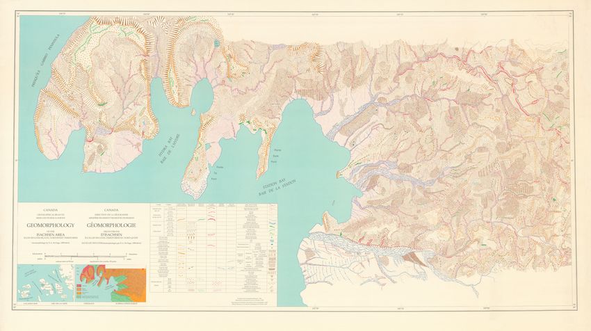
                                     APPENDIX                                           part of these slopes. Steep-sided terraces are frequent on the
                                                                                        upper surfaces of gabbro ridges, on the map these are inter-
           GEOMORPHOLOGY OF THE ISACHSEN AREA
                                                                                        preted as nivation terraces but recent studies suggest they
              A geomorphological map of the Isachsen area is available                  are glaciofluvial channels although no associated sediments
           in PDF format at the GpQ web-site with on-line version of this               have been identified (Atkinson, 2003).
           paper at:
                                                                                          In the southeast, sandstone of the Isachsen Formation
                 http://www.erudit.org/revue/gpq/2005/v59/n2-3/index.html
                                                                                        underlies a hilly region dissected by numerous gullies and
               The geomorphological map, with a process-based legend,                   moderately to steep-sided valleys. Here, erosion along orthog-
           depicts the landforms of the west-central part of Ellef Ringnes              onal joints has produced numerous stone pillars.
           Island. The map illustrates the influence of both geological struc-
                                                                                            The central part of the map area is a low plain eroded on
           ture on macro landforms and of lithology on the variety of meso
                                                                                        shales of the Deer Bay Formation which is drained by the
           and macro landforms. As geomorphological mapping has been
                                                                                        Delta River and other streams flowing in broad alluvial beds to
           largely abandoned, the geomorphological map of Isachsen area
                                                                                        deltas in Deer Bay. A variety of patterned ground cover this
           remains a unique example of portraying the complex interrela-
                                                                                        rolling lowland. Here, as elsewhere on the island, periglacial
           tions of processes active in a high arctic region.
                                                                                        landforms are closely linked to lithology.
               Active geomorphic processes are discussed in detail for
           the Isachsen area located in west-central part of Ellef Ringnes                 Periglacial features such as patterned ground, albeit spec-
           Island (Fig. 1).                                                             tacular, are but minor features on the fluvial-dissected, struc-
                                                                                        turally-controlled landscape of Ellef Ringnes Island.
           LITHOLOGICAL CONTROL                                                            Detailed instrumented field measurement to identify and
              The high gabbro ridges in the northwest of the Isachsen                   quantify processes associated with snowbanks in high lati-
           area rise to over ~240 m asl (Fig. 8). From vertical rock out-               tudes still needs to be done. The role of geologic structure, in
           crops at their edges steep slopes are mantled by coarse open                 spite of its high visibility in imagery from space, does not
           work scree slopes which descend to the valleys or ocean                      appear to be an important preoccupation in current scientific
           below. Stony solifluction lobes commonly deform the lower                    periglacial geomorphology literature.

                                                                                                                       FIGURE 8. Oblique air photograph
                                                                                                                       of the Station Bay area looking
                                                                                                                       west. This view covers most of the
                                                                                                                       area of the detailed geomorpholog-
                                                                                                                       ical map. Gabbro mesas and gen-
                                                                                                                       erally circular dike ridges dominate
                                                                                                                       the landscape in the north with val-
                                Deer Bay                                             Hospital Bay                      leys carved in intervening shale.
                                                              Reindeer Peni                                            The Delta River has eroded a broad
                                                                            nsula
                                                                                                                       lowland in the shale of the Deer Bay
                                                                                                                       Formation. Note the snowbanks
                                           Gabbro Peninsula                                                            along the south facing slopes of
                                                                                                                       gabbro mesas and along the banks
                                                                                                                       of Delta River (Source: National air
                                                                                                                       photo library T411R-41).
                                                                                                                       Photographie aérienne de la baie
                                                                                                                       de la Station avec une vue oblique
             Station Bay                                                                                               vers l’ouest. Cette vue couvre la
                                                                                                                       majeure partie de la région de
                                                                                                                       la carte géomorphologique. Des
                                                                                                                       mésas et des crêtes circulaires de
                                                                                                                       gabbro entrecoupées de vallées
                                                                                                                       dans les roches schisteuses domi-
                                                                                                                       nent le paysage de la partie nord.
                                                                                                                       La rivière Delta occupe une large
                                                                                                                       plaine dans les schistes de la for-
                                                                                                                       mation Deer Bay. Notez la présence
                                 Delta River
                                                                                                                       de congères sur les pentes sud des
                                                                                                                       mésas et les versants de la rivière
                                                                                                                       Delta (Source : Photothèque natio-
                                                                                                                       nale T411R-41).

                                                              Géographie physique et Quaternaire, 59(2-3), 2005
You can also read