NEST 4C-1.1: an ESA toolbox for scientific exploitation of SAR data - Andrea Minchella
←
→
Page content transcription
If your browser does not render page correctly, please read the page content below
NEST 4C-1.1: an ESA toolbox for
scientific exploitation of SAR data
Andrea Minchella
RSAC c/o European Space Agency ESRIN
EO Science, Applications and New Technologies Department
Exploitation & Services Division
Contents

• NEST Project Overview & Context

• NEST Architecture

• NEST Features

• Hands-on exercise - The link between PolSARpro & NEST
What is NEST
•   NEST = Next ESA SAR Toolbox

•   A free and fully open source toolbox under the GNU GPL license
•   Supports the scientific and operational exploitation (reading, processing, analysing and
    visualising) of ESA and 3rd party spaceborne SAR data
•   Project KO in November 2007, current version number is NEST 4C-1.1

                  SAR Mission Reader
                     ENVISAT ASAR

                        ERS-1&2

                       Radarsat-2

                     Cosmo-SkyMed

                       TerraSAR-X

                      ALOS PALSAR
                                                                      2013
                                                                  Sentinel 1 A-B
                       Radarsat-1

                       JERS SAR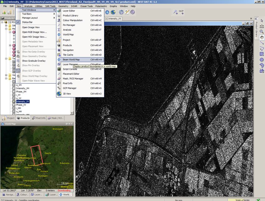
NEST Development Team

NEST is being developed under ESA Contract number 20698/07/I-LG

NEST TEAM

1. ESA
   Marcus Engdahl (ESA Technical Officer), Andrea Minchella (RSAC c/o ESA)
2. Array Systems Computing (prime)
   Rajesh Jha, Luis Veci, Jun Lu, Shengli Dai
3. Brockmann Consult
   Norman Fomferra, Marco Peters
4. PPO.labs (InSAR)
   Petar Marinkovic
5. TU Delft (InSAR)
   Prof. Ramon Hanssen
NEST Architecture

- NEST is built re-using the proven BEAM Earth Observation Toolbox and Development
 Platform (http://www.brockmann-consult.de/cms/web/beam/welcome)

    • Reduced development cost

    • Development synergy – thanks to the shared NEST-BEAM Core plug-in modules for
      both toolboxes are largely interchangeable.

    • Easy expandability (BEAM processors, etc.)

- Java implementation: guarantees platform independence and easy portability
 (Windows, Linux, Mac)

- Advanced features include:

    • A “Tiled” memory model

    • Multi-core processor support

    • Modular design (plugins)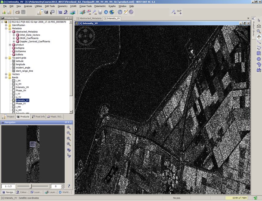
NEST Architecture: data flow

                                  Display and Analysis Tool (DAT)
                         Integrated graphical user interface for SAR data visualisation,
                                           analysis and processing

ENVISAT ASAR
                                                                                                      Beam dimap
  ERS-1&2
                                                                                                        Geotiff
 Radarsat-2

Cosmo-SkyMed
                                      Generic Product Model (GPM)                                       Netcdf
               Readers                                                                     Writers
                                              NEST-BEAM core                                              Envi
 TerraSAR-X
                                                                                                     Generic Binary
ALOS PALSAR
                                                                                                     Google Earth
 Radarsat-1                                                                                            PolSARpro
  JERS SAR

                                    Graph Processing Tool (GPT)
                                For command line execution of user-defined
                                        batch processing chains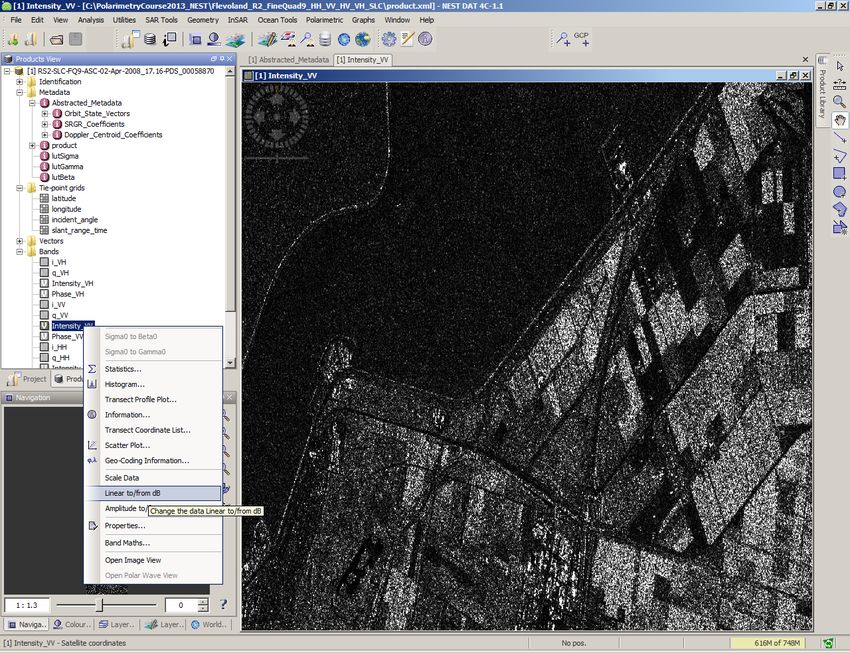
Display and Analysis Tool (DAT)

    •   Products View

    •   Projects View

    •   Pixel image information

    •   Metadata/header

    •   Statistics

    •   R.O.I. Tool

    •   Navigation

    •   Colour (LUT) Management

    •   Layer Management (Image & shape overlay)

    •   World Maps (NASA WorldWind integration)

    •   Flexible windows management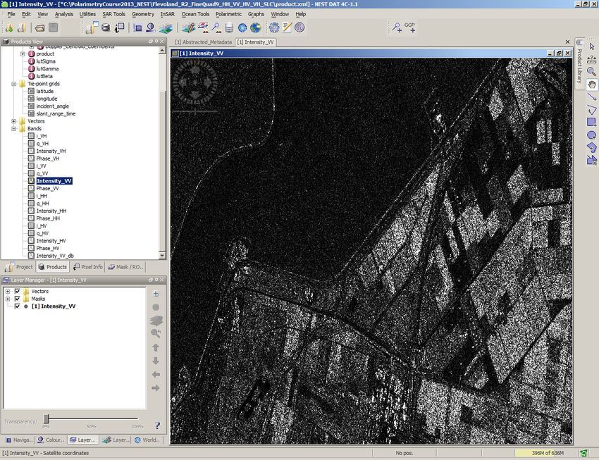
Graph Processing Tools

• Create your own processing chains & save in XML
• Visual Graph Processing Framework interface
• Executed from command line or from GUI
• Allows for batch processing on stack of images
• Very useful for large-scale operational processing
NEST Features

–Readers and Product library

–Utilities

–(Basic) SAR Tools

–(Advanced) SAR Tools: Geometry, InSAR, Ocean
Readers

          SAR data     Common EO        Compatibility
           readers       formats         with other
                                          software

      ENVISAT ASAR        GeoTiff           Envi

           ERS-1&2       HDF 4 & 5       PolSARpro

      ALOS PALSAR         NetCDF            BEAM

      Radarsat-1&2     Generic Binary

          TerraSAR-X

           Cosmo-
           SkyMed

          JERS SAR

      http://earth.eo.esa.int/polsarpro/
The Product Library
• Convenient browsing and importing of products
having information and product previews.
• Import to a project
• Apply batch processing chainUtilities • ERS & ASAR precise orbit handling (Delft, ESA Doris and Prare orbits) • Band Arithmetic • Data Conversion • Subset and Resampling • Metadata inspection and replace • Image Filtering • Create layers stack • Image Analysis - Principle Component Analysis - EM Cluster Analysis (Beam tool) - KMeans Cluster Analysis (Beam tool)
(basic) SAR Tools*
                              • Absolute calibration (Envisat ASAR, ERS 1&2, ALOS, Radarsat-2,
                                TerraSAR-X, Cosmo-SkyMed)

                              • Coregistration of detected and complex products

                              • Multilooking

                              • Speckle filtering (single and multitemporal filtering)

                              • Debursting of ASAR WSS

* Level of support depends on sensor & product type. Please refer to NEST documentation
for full details
 • Operators help
 • Supported_Products&MainTools.xls
available in the Documentation page on NEST website at
http://liferay.array.ca:8080/web/nest/documentation
Geometry • Range-Doppler Terrain Correction (backward geocoding) • Simulated SAR Terrain Correction with GIM mask • Radiometric normalization during Terrain Correction • Ellipsoid correction • Map Reprojection • Mosaicking • DEM tools
Geometry (cont.)

                                            Radiometric Normalization
   Mission     Range Doppler TC/SAR         (Approach:Kellndorfer et al.,
                   Simulation TC                TGRS, Sept. 1998)

               Both complex and detected     Both complex and detected
   ASAR            products supported            products supported
               Both complex and detected     Both complex and detected
    ERS            products supported            products supported
               Both complex and detected     Both complex and detected
RADARSAT-2         products supported            products supported
               Both complex and detected     Both complex and detected
Cosmo-SkyMed       products supported             products supported

 TerraSAR-X    Complex products supported    Complex products supported
InSAR: NEST-DORIS
Algorithmic integration of DORIS
(TU Delft Radar Interferometric Software)
• Fully integrated and featured InSAR processor
within NEST
• Coregistration and resampling
• DEM assisted coregistration
• Products: interferogram and coherence
• Filtering: both spectral and phase
• Geo-coding
• Unwrapping via 3rd party sw (SNAPHU)
• DEM product
• Differential InSAR
Only zero doppler and strip map data are
Available in 4C fully supported
Available in 5A-1.0 (Beginning 2013)Ocean Tools • Object (ship) Detection • Oil Spill Detection • Wind Field Estimation • Create Land Mask Land Masked Detection Map Projected
What's new in NEST 4C
• Interferometry
Phase filtering
Integration with SNAPHU for phase unwrapping
Phase to height conversion
DEM generation
Three-pass differential InSAR
InSAR stack overview and selection of an optimal master product
Bug fixes and performance improvements
• ENVI export with georeferencing
• Selectable target format for batch processing
• ArcInfo Binary Grid reader
• Improved coregistration of polarimetric products
• ASTER GDEM v2 support
• Improved SAR Simulation Terrain Correction
• Better PolSARPro integration
• Ellipsoid Correction Range-Doppler: selectable pixel size
• Cosmo-SkyMed Wide Swath (detected) calibration
• Bug fixesOn going development (2012-13)
Technical Req No. Usability Improvements
TRN.01.070 Report generation tools
TRN.01.080 Improvement of subset operator: Graphical subset selection, harmonisation with GPF, execution of
subset without displaying the full image, choice to direct save the output.
Extended TerraSAR-X Support
TRN.02.010 TerraSAR-X Rigorous calibration according to official documentation http://www.astrium-
geo.com/files/pmedia/public/r465_9_tsxx-itd-tn-0049-radiometric_calculations_i1.00.pdf
TRN.02.020 Extension of Terrain Correction operator to TERRASAR-X detected product
InSAR Tools
TRN.04.010 Implementation of the Statistical-cost, Network-flow Algorithm for Phase Unwrapping proposed by
Chen and Zebker
TRN.04.020 Extensions of developed InSAR coregistration modules and other InSAR modules for cross
interferometric applications.
TRN.04.030 Enhanced DEM Assisted Coregistration implementation
TRN.04.040 Optimisation of coregistration module for InSAR processing implementing the 'conventional' 3-step
correlation optimization algorithm.Further information For software upgrades, documentation and more information regarding the NEST project, please visit the website at http://earth.esa.int/nest
Hands-on exercise - The link between PolSARpro & NEST

The main objective is to show:

how Geocoding the entropy derived by a Radarsat-2 Full

Polarimetric image (processed by PolSARpro) using the new

PolSARpro capability bridge with the NEST.

                                                            21
Main Exercise steps
• Open and Inspect the Radarsat 2product
• Overlay different polarisation bands Using the NEST DAT
• Geocoding (Terrain Correction) using STRM DEM
• Pre-processed data (Filtered T3 and H/A/Alpha) by PolSARpro ingestion
• Set-up of NEST from PolSARpro
• Import PolSARpro T3 folder products
• Display the Entropy and compute statistics
• Apply a LUT (Look up table)
Using the NEST DAT
• Geocoding the Entropy with the new PolSARpro tool bridging NEST
• Open Geocoded Entropy
• Export to Google Earth Using the NEST DATBefore starting: Installing NEST
In DVD 1 from folder called Software\NEST:
- Proceed with installation of NEST according to
your OS (32bit or 64bit):
NEST-4C-1.1-windows-installer.exe (32bit)
NEST-4C-1.1-windows64-installer.exe
23Before starting: the Dataset
In DVD1 from folder called Data_Minchella:
1. Unzip the file called PolarimetryCourse2013_NEST.zip under C:\ of your PC
C:\PolarimetryCourse2013_NEST
2. Copy the folder called AuxData under C:\ of your PC
C:\AuxData
Radarsat-2 fine Full Polarisation
Area: Flevoland in the Netherlands
This dataset is free available from the following link:
http://gs.mdacorporation.com/SatelliteData/Radarsat2/SampleDataset.aspx
24Main Exercise steps
• Open and Inspect the Radarsat 2product
• Overlay different polarisation bands Using the NEST DAT
• Geocoding (Terrain Correction) using STRM DEM
• Pre-processed data (Filtered T3 and H/A/Alpha) with PolSARpro ingestion
• Set-up of NEST from PolSARpro
• Import PolSARpro T3 folder products
• Display the Entropy and compute statistics
• Apply a LUT (Look up table)
Using the NEST DAT
• Geocoding the Entropy with the new PolSARpro tool bridging NEST
• Open Geocoded Entropy
• Export to Google Earth Using the NEST DATNEST DAT
Double click on NEST icon for launching NEST
DAT
(Display and Analysis Tool)
To open the data in the Products View few ways are available:
• Readers
• Open Raster product
• Product Library.
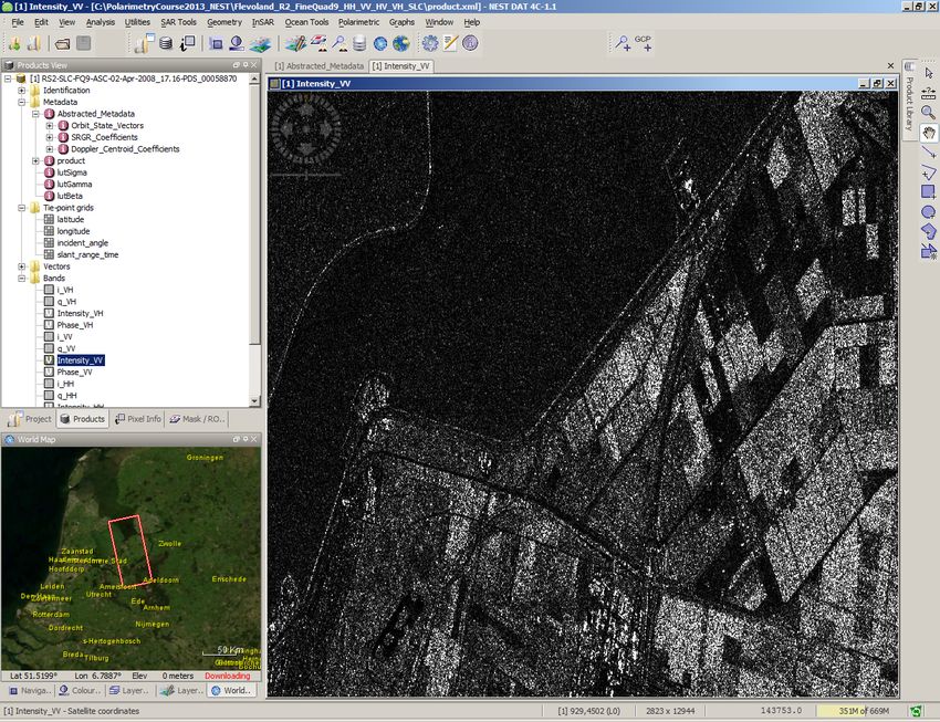
• Drag the product directly from the folder where data is located.Open the Radarsat-2 product
C:\PolarimetryCourse2013_NEST\Flevoland_R2_FineQuad9_HH_VV_HV_VH_SLC
27Inspect product structure
• Identification: Basic information on the product (Mission, Product
type, Acquisition time, Pass, Track and Orbit)
• Metadata: This includes all the original metadata within the
product, the Abstracted Metadata which is the important metadata
fields used by the Operators in a common format and the Processing
graph history recording the processing that was done
• Tie Point Grids: Raster grids created from interpolating the tie-points
information within the product. The interpolation is done on the fly
according to the product.
• Bands: The actual bands inside the product and virtual bands created
by NEST from expressions. Different icons are used to distinguish
these bands.
28The (NEST) abstracted metadata
View the band’s product: display a band (VV)
Mouse left button double click on the band name to view it.Zoom in the Intensity_VV
Zooming in using the sliding tool
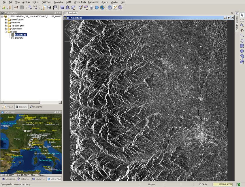
31Display the product in a flat Earth view (NASA WorldWind)
To use the WorldWind World Map and 3D View:
• Internet connection required
• 3D video card Graphic Card supporting open GL
libraryDisplay the product in BEAM flat Earth view
• No Internet connection required
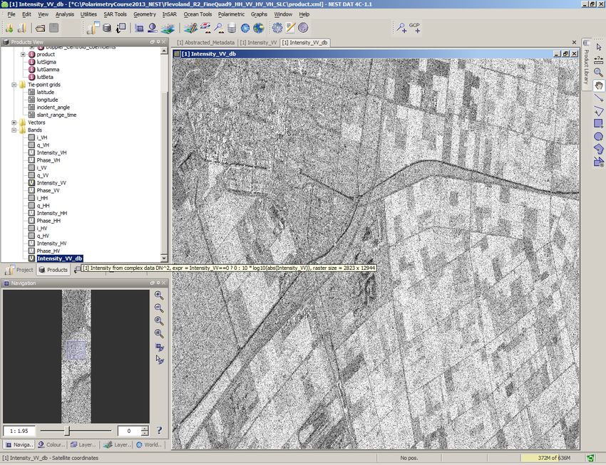
• Low resolution imageConversion from Linear to db • Mouse Right click over the band name • Select Linear to/from dB
Conversion from Linear to db Mouse left button double click on the band name to view it.
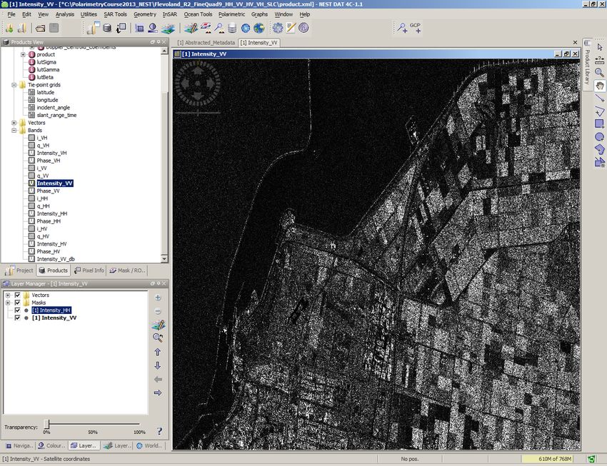
Overlay the different polarisation bands
1. From Layer Manager click on + button
2. Add Layer Image of Bands/Tie-Points Grid
3. Click “Next”Overlay the different polarisation bands
4. Select Intensity_HH with mouse Left button click
5. Click FinishOverlay the different polarisation bands
Experiment the Transparency capability6. Geocoding (Terrain Correction) using STRM DEM: The Settings window NEST is able to download automatically the STRM v.4 (3” tiles) from the JRC FTP (xftp.jrc.it) for the area covered by the image to be orthorectified. The tiles will be downloaded to the folder C/AuxData/DEMs/SRTM_DEM/tiff. Also Delft and ESA orbits are automatic downloaded. Internet is required! And your firewall must allow that. If your Internet settings are preventing the downloading, you still can download by yourself the DEM tiles and/orbits and put these manually in the NEST Settings Window directories.
The Test Connectivity In the HELP tab there is a “Test Connectivity” capability to check if the connection works well. Sometime even if Connection testing is successful, the PC settings could prevent the downloading
Geocoding (RD Terrain Correction – backward geocoding) using STRM
DEM: parameters
A default pixel spacing is computed with
parameters in the metadata.
Beside this, user can specify output pixel
spacing for the orthorectified image.Geocoding (Terrain Correction) using STRM DEM: parameters
Geocoding (Terrain Correction) using STRM DEM: parameters
Main Exercise steps
•   Open and Inspect the Radarsat 2product
•   Overlay different polarisation bands                          Using the NEST DAT
•   Geocoding (Terrain Correction) using STRM DEM

•   Pre-processed data (Filtered T3 and H/A/Alpha) by PolSARpro ingestion
•   Set-up of NEST from PolSARpro
•   Import PolSARpro T3 folder products
•   Display the Entropy and compute statistics
•   Apply a LUT (Look up table)
                                                           Using the NEST DAT

•   Geocoding the Entropy with the new PolSARpro tool bridging NEST
•   Open Geocoded Entropy
• Export to Google Earth Using the NEST DATLauch PolSARpro
Radarsat-2 widget selection Select RADARSAT-2 satellite icon: Mouse left button click over Quad-Pol
Environment setting

1.   Click over Environment

2.   Select as Main Input Directory

3.   Click “Save & Exit”
Pre-applied processing
Configuration
Input Data File
Data Import Extract Raw Data
[T3] Elements Full Res
Batch Processing
Data Process [T3] Elements
Speckle Filtering
Box Car
H / A / alpha Decomp.
48Pre-applied processing: Filtered T3 and H/A/Alpha decomposition
Pre-applied processing:
Filtered T3 and H/A/Alpha decomposition
Entropy.bmp
50NEST Configuration 1. Select the nest-dat.exe 2. Save & Exit
Run NEST
Import PolSARpro T3 folder products
Import PolSARpro T3 folder products
PolSARpro
     Thacted
          T3 folder
              metadata
                    metadata
View the band’s
Thacted
product:
metadata
display the Entropy
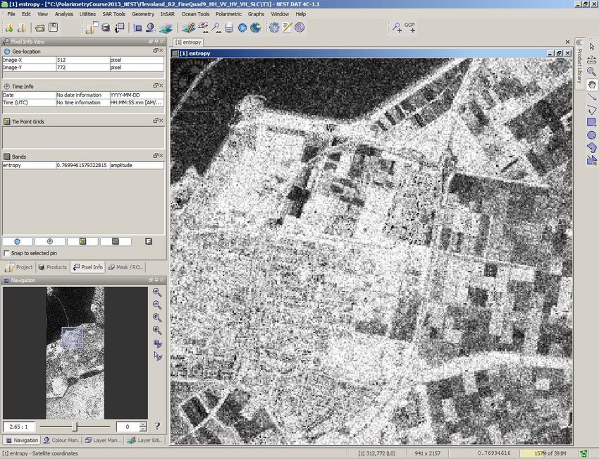
Mouse left button double click on the band name to view itPixel info Entropy data range value: [0,1]
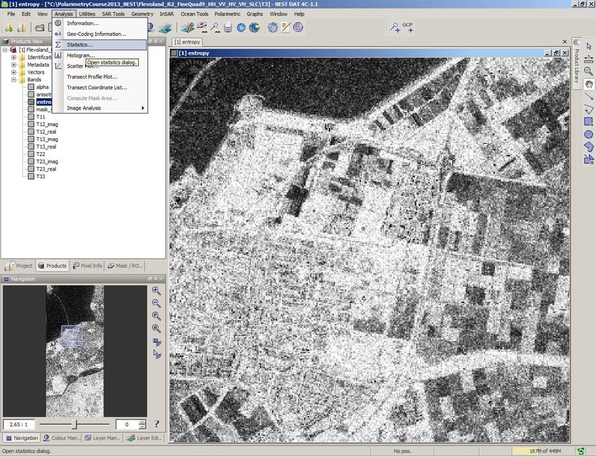
Statistics
  Thactedcomputation
           metadata
ApplyThacted
a LUT (Look
metadata
up table)
1. Click to Colour manipulation
2. Import a Colour palette (Spectrum.cpd)
Open
3. Click ApplyApplyThacted
a LUT (Look
metadata
up table)Main Exercise steps
• Open and Inspect the Radarsat 2product
• Overlay different polarisation bands Using the NEST DAT
• Geocoding (Terrain Correction) using STRM DEM
• Pre-processed data (Filtered T3 and H/A/Alpha) by PolSARpro ingestion
• Set-up of NEST from PolSARpro
• Import PolSARpro T3 folder products
• Display the Entropy and compute statistics
• Apply a LUT (Look up table)
Using the NEST DAT
• Geocoding the Entropy with the new PolSARpro tool bridging NEST
• Open Geocoded Entropy
• Export to Google Earth Using the NEST DATNEST GPT
Thacted
Command
metadata
Line interface
• PolSARpro employs the NEST GPT engine in the bridge with NEST
• Make running the gpt from any folder, set the NEST_HOME variable:
1. On Windows go to Control Panel -> System -> Advanced -> Environment Variables
2. Add a variable for NEST_HOME to point to the installation folder and also include
%NEST_HOME% in the PATH variable.NEST GPT
Thacted
Command
metadata
Line interface
• Open the Command Prompt and type gpt
• If set-up has been properly done you should get:Geocoding the Entropy
Thacted
withmetadata
the new tool bridging NEST
1. Input: entropy
2. Browse for the product.xml of
the Radarsat-2 data
3. Click OKGeocoded Entropy
Envi Format
65Open Geocoded Entropy in NEST
66Open Geocoded Entropy in NEST
67Apply a LUT
1. Click to Colour manipulation
2. Import a Colour palette (Spectrum.cpd)
Open
3. Click Apply
68Thacted
Applymetadata
a LUTOverlay the Geocoded Intensity VV
Drag the .tiff file directly into the product view
70Overlay the Geocoded Intensity VV
1. From Layer Manager click on + button
2. Add Layer Image of Bands/Tie-Points Grid
3. Click “Next”Overlay the Geocoded Intensity VV
4. Select Intensity_HH with mouse Left button click
5. Click FinishOverlay the Geocoded Intensity VV
73Export to Google Earth
74Export to Google Earth
75Hands-on exercise - The link between PolSARpro & NEST
The main objective was to show:
how Geocoding the entropy derived by a Radarsat-2 Full
Polarimetric image (processed by PolSARpro) using the new
PolSARpro capability bridge with the NEST.
Any questions??
76THANK YOU Andrea Minchella RSAC Ltd. c/o European Space Agency ESRIN EO Science, Applications and New Technologies Department Andrea.Minchella@esa.int
You can also read