Northern U.S. Blizzard: Another 24 Hours To Go - World Weather Inc.
←
→
Page content transcription
If your browser does not render page correctly, please read the page content below
Northern U.S. Blizzard: Another 24 Hours To Go
By Andrew Owen
Kansas City, April 11 (World Weather Inc.) – Heavy snow and strong wind speeds
evolved from portions of Colorado and eastern Wyoming into South Dakota, southern
Minnesota and portions of Nebraska Wednesday and overnight as a strong winter storm
began tracking across the U.S. Plains. Additional snow will occur today and Friday in
portions of the northern Plains and Upper Midwest with strong wind speeds still
occurring. Blizzard conditions closed many roads overnight from Nebraska through
South Dakota and into parts of western Minnesota and caused significant travel delays
that may last for another day or two. Livestock stress has reached extreme levels in some
locations where the strongest wind, heaviest snow and coolest temperatures are present.
Concern over worsening flood conditions will also grow as the snow melts later in the
forecast period. Planting and fieldwork delays will likely be extended into May over much
of the impacted region in the northern Plains and Upper Midwest.
{Be sure to see the timeline for other big storms noted at the end of this report.}
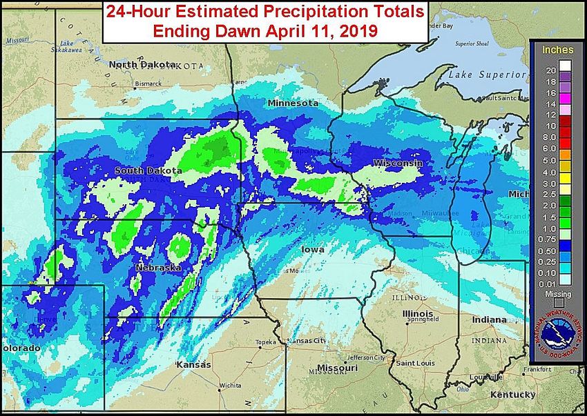
Snowfall during the past day was greatest from northern Nebraska and southeast
Wyoming into much of South Dakota outside the southeast corner and portions of southern
Minnesota and western and central Wisconsin. Accumulations for the 24-hour period ending
dawn this morning ranged from 6 to 18 inches with portions of eastern South Dakota
receiving more than 18 inches of snow. Other areas in eastern Wyoming into portions of
eastern Colorado, northwest Kansas, and southwest and central Nebraska also received 2 to
8 inches of snow.
Moisture content in the snow that fell over the past 24 hours ranged from 0.25 to
2.00 inches with local totals up to 2.50 inches in eastern South Dakota and southern
Minnesota. Topsoil moisture conditions prior to the snow event in eastern Colorado,
1
Northern U.S. Blizzard: Another 24 Hours To Go
northwestern Kansas, western Nebraska and eastern Wyoming was rated short to very
short making the precipitation event a boon to future wheat and hay development.
However, portions of eastern South Dakota, southern Minnesota and Wisconsin were
already dealing with moisture abundance and flooding was well under way in many areas
making this precipitation event totally unwelcome and raises the potential for more
serious flooding as the snow begins to melt later this month.
        Strong wind speeds were associated with the heavy snow in several locations. Wind
gusts near and above 50 mph were noted at times with portions of eastern Colorado
reporting gusts upwards of 100 mph. Low visibilities and heavy snow significantly crippled
travel in many areas. Major highways were closed as a result of the blizzard and several
days may be needed before secondary and rural roadways are again passable.
        The center of low pressure will slowly advance into southern Minnesota today
before moving across Wisconsin and Lake Superior Friday. Heavy snow will still occur on
the backside of the disturbance from northern Nebraska through portions of central and
eastern South Dakota, western and central Minnesota, and portions of northern and central
Wisconsin. New accumulations will range from 6 to 14 inches for these areas with several
locations in eastern South Dakota and extreme western Minnesota receiving 16 to nearly 24
inches of snow. Other portions of Nebraska, western South Dakota, and southern and
eastern North Dakota will receive a dusting to 3 or 4 inches of snow with local amounts of 8
inches or more in southeast North Dakota.

        Sustained wind speeds for portions of the northern Plains and Upper Midwest will
often range from 25 to 40 mph and gusts of 55 mph or higher at times throughout the day.
Travel delays will likely be extended for areas that receive the most snow and the delays

                                                                                               2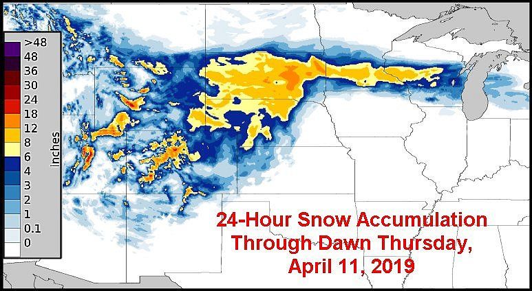
Northern U.S. Blizzard: Another 24 Hours To Go
will not only impact land and rail transportation, but air travel will also be disrupted
especially commercial flights that pass through the Minneapolis, Minnesota area.
        Livestock stress will continue at serious levels today and with the deepening
snowpack and relentless wind and blizzard conditions the animals are going to be tired.
The more tired cattle and other livestock become the greater the potential that they will
lay down in the snow. Once the animals are down they may have trouble getting up again
and that is when the potential for suffocation starts to increase. Some of the livestock has
already endured more than 16 hours of harsh winter conditions and will have to deal with
it for nearly another 24 hours. That will raise concern over animal health and raise the
potential for deaths.
        Flood concerns will remain from portions of Nebraska and South Dakota into
Minnesota and Wisconsin over the next few weeks. Several of these areas have already seen
severe flooding over the past few weeks and this storm will only prolong the situation and
may induce some additional rises in flood water levels. The ground is still saturated in many
areas and the melting snow will only raise the runoff and expand the area of concern for
damaging conditions over farmland and into some urban and industrial areas.
        Fieldwork is still expected to get off to a poor start this year in many of the wettest
areas and if the wet biased pattern prevails as some believe it will there will likely be poor
establishment with uneven emergence and staggered crop harvest dates.

                                                                                                  3
Northern U.S. Blizzard: Another 24 Hours To Go
Improving weather conditions will occur this afternoon and tonight across the west-
central high Plains region. Improvements in South Dakota and southeastern North Dakota
will begin Friday morning. Minnesota, Wisconsin and some easternmost Dakota locations
may not see the snow end until Friday afternoon and Friday night. However, once the storm
passes the region is expecting to see quieter weather for at least a full week and possibly
ten days thereafter. Totally dry weather is not likely, but no more big snow or rain events
will evolve in the upper Midwest and any precipitation that occurs will be too brief and light
to add to the region’s woes.
OTHER STORMS TO CONSIDER
However, with that said two storms will pass through the central and lower Midwest
and Delta (one this weekend and the other during mid-week next week) followed by third
storm that will impact the northern Plains and upper Midwest before reaching the eastern
Midwest April 21-23. A very important break in weather may occur April 23-28 before
the next large storm arrives in the Plains and western Midwest April 29-30.
The best drying period may occur in the first ten days of May, but that outlook
comes from our Trend Model and confidence is a little low. More stormy weather would
then resume from the central Plains into the Midwest during mid-May with late May
weather most active in the northern Plains, southern Canada’s Prairies and the Great Lakes
region. Spring planting progress will advance most significantly between the larger storms
mentioned above with the most aggressive fieldwork anticipated for the first ten days in
May
World Weather, Inc. forecasts and comments pertaining to present, past and future weather conditions included in
this report constitute the corporation's judgment as of the date of this report and are subject to change without notice.
Comments regarding damage or the impact of weather on agricultural and energy as well as comments made
regarding the impact of weather on the commodity and financial markets are the explicit opinions of World
Weather, Inc. World Weather, Inc. can not be held responsible for decisions made by users of the Corporation's
information in any business, trade or investment decision.
©2019 World Weather, Inc. Any unauthorized redistribution, duplication or disclosure is prohibited by law and will
result in prosecution.
4You can also read