NOTE ON POST DISASTER STUDIES FOR LANDSLIDES OCCURRED IN JUNE 2018 AT IDUKKI DISTRICT, KERALA - GSI
←
→
Page content transcription
If your browser does not render page correctly, please read the page content below
NOTE ON POST DISASTER STUDIES FOR LANDSLIDES
      OCCURRED IN JUNE 2018 AT IDUKKI DISTRICT, KERALA

                              Field Season 2018-2019
                      FSP No: M4SI/NC/SR/SU-KRL/2018/21108

                             Sulal N. L., Senior Geologist
                            Archana K. G., Senior Geologist

       Under GSI’s ‘Post disaster studies in Kerala’ a team of two geoscientists carried out
post event studies at 10 recently occurred landslides locations in Idukki district, Kerala during
the months of June and July. Slope failures were reported from 9th June, 2018 in different
parts of Idukki district, Kerala falling in Survey of India toposheet nos. 58B/16, 58C/03, 58
F/04 and 58G/01. This report pertains to the initial assessment of the landslide affected areas,
suggestions rendered as immediate corrective measures and the 42 point detailed geo-
parametric attributes of the landslide inventory.
       In general, the geomorphic terrain of the area is divided into four viz. rugged hills,
ridges and valleys, fringe slope and plateau. Majority of the landslides studied fall in the
fringe slopes of rugged hill bordering the Munnar plateau of the Western Ghats. Moderately
dissected slope and lowly dissected slope are the major geomorphic unit encountered in the
slided area. A few perennial springs spout at different places, indicating the shallow depth of
ground water level.

               Fig:Aerial view of all landslide locations from Google imagery.

                                                                                               1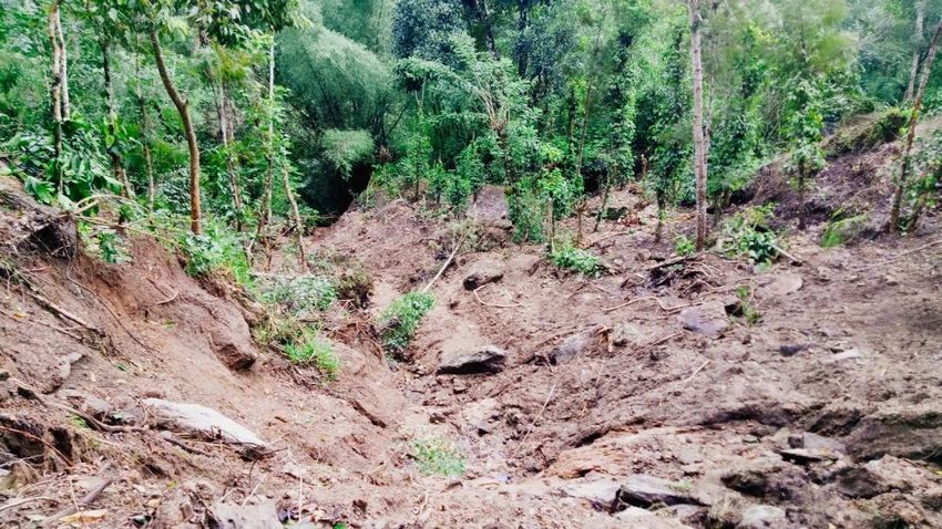
Fig: Location map of landslide incidences at Idukki District
Geologically the area forms a part of the Precambrian metamorphic shield of South
India comprising rocks of the Wayanad, Khondalite, Charnockite and Migmatite Groups.
Major rock units of the area are the garnet biotite gneiss, hornblende biotite gneiss, pink
granitegneiss and small patch of charnockite body.
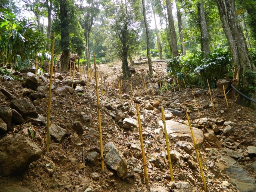
The preparatory factors observed in the study are weathering, loading of the slope or
its crest, excavation of the slope of its toe, defective maintenance of drainage systems, land
use and land cover including road and other physical features, physical state of slope such as
slope gradient, slope aspect and slope curvature and physical characteristics of slope forming
mass. Slope failures are more common along the road corridors and the corridors are highly
susceptible to failures as the thick column of vertically cut old debris/soil mass remained
untreated after the construction of road. Incessant torrential rain started from 08th of June,
2018 in Idukki district is assessed to be the triggering factor. The cumulative rainfall graph of
Idukki district during the SW monsoon is given below.
2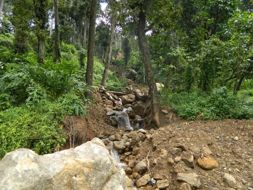
(Source: Indian Meteorological Department, Thiruvananthapuram)

     The 42 point detailed geo-parametric attributes of landslide inventory are given below:
     Location 1:
No           Field                                                Description
1  Slide No.                     : KER/IDK/58F04/2018/01
2    State                       : Kerala
3    District                    : Idukki
4    Toposheet No.               : 58F/04
5    Name of the slide           : KallarVattiyar
6    NH/SH/Locality              : NH – 49 (Kochi – Dhanushkodi Road)
7    Latitude                    : 10.0372 N
8    Longitude                   : 77.0068 E
9    Length                      : 60m
10   Width                       : 30m
11   Height                      : 60m
12   Area                        : 1800m2
13   Depth                       : 4m (approx.)
14   Volume                      : 7200m3

                                                                                                      3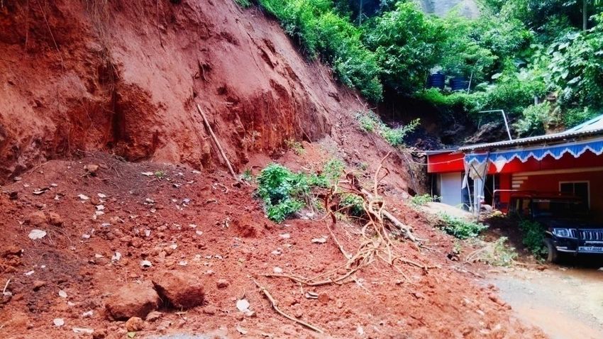
15   Run out distance         : 70m
16   Type of Material         : Rock-cum- debris
17   Type of movement         : Flow
18   Rate of movement         : Very Rapid
19   Activity                 : Active
20   Distribution             : Advancing
21   Style                    : Single
22   Failure mechanism        : Shallow planar (≤ 5m) failure
23   History                  : Date of initiation: 09th June, 2018
24   Geomorphology            : Moderately Dissected Slope, Slide direction is towards S7°W
25   Geology/Lithology        : Pink Granite Gneiss
26   Structure                : -
27   Landuse/ Landcover       : Low Height Plantation (Cardamom)
28   Hydrological condition   : Flowing
29   Triggering Factor        : Rainfall
30   Death of persons         : Nil
31   People affected          : 2 persons got injured
32   Livestock Loss           : Nil
33   Communication            : NH – 49 (Kochi – Dhanushkodi Road) damaged and blocked for
                                hours.
34   Infrastructure           : One house partially damaged, one culvert completely damaged.
35   Agriculture/forest/Barren : Agriculture: Cardamom, mixed cultivation.
36   Geo-scientific Causes    : Loosening the overburden for cardamom plantation, adverse
                                cultivation pattern, defective maintenance of drainage systems along
                                with reduction of strength on super saturation due to continuous
                                shower. The natural course of the drainage was blocked for
                                cardamom plantation.
37   Remedial measures        : As an immediate measure the loose unsorted debris should be
                                removed retaining the natural course of the nala and construction of
                                a proper culvert for the free flowing of water across the road. The
                                next step is the restriction of unscientific hill slope modification. The
                                hill slope modification if required may be carried out after
                                considering the slope stability and engineering aspects. Proper land
                                use practice must be followed along the vulnerable slopes. Terracing
                                and contour bounding should not be allowed along the slope. People
                                must be educated about the importance of proper land use practices
                                to minimise the risks. Afforestation of the slope with suitable plant
                                species has to be done.
38   Remarks, if any            If immediate remedial measures not taken, the chances are very high
                                for reactivation.

                                                                                                4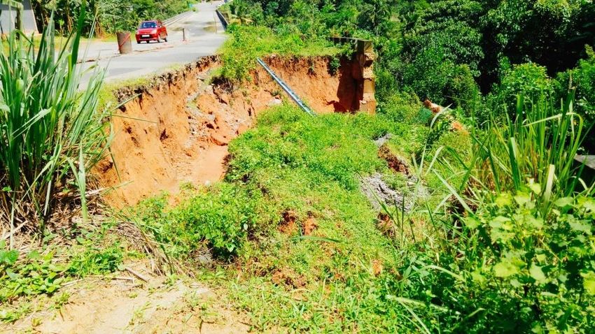
39   Photos. Sketch of Plan & :
     section of the slide

                                       Fig: The upper part of the failed surface.

                                                 Fig: The run out path.

                                  Fig: Accumulation of failed mass on the slope break.

                                                                                         5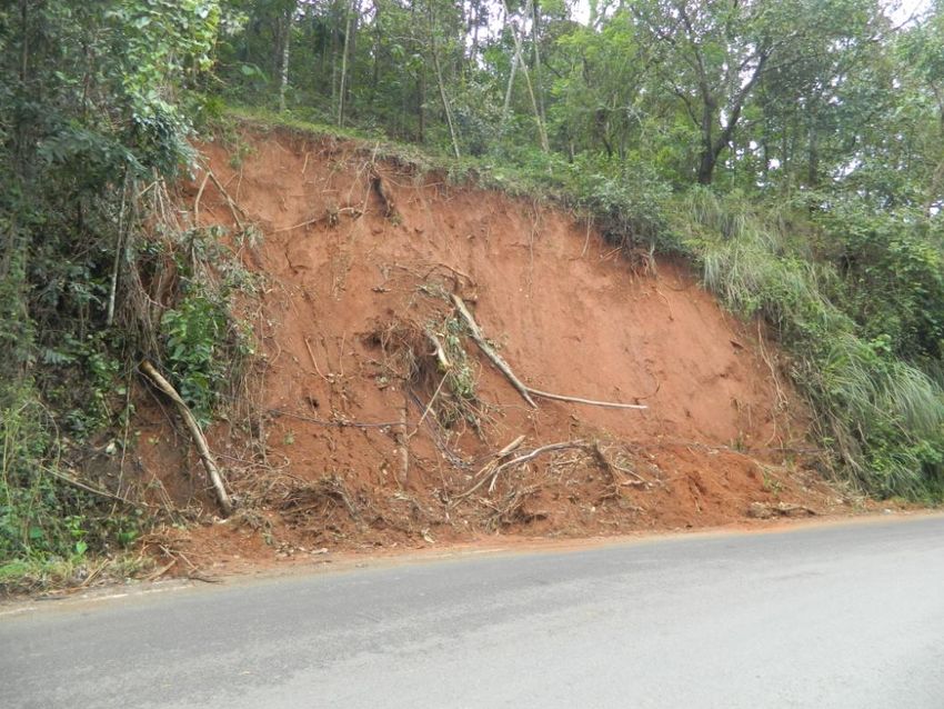
40    Summary/Abstract     : A debris flow occurred in Kallar-Vattiyar area, Pallivasal Village,
                             Devikulam Taluk, Idukki district at about 1900hrs on 9th June, 2018.
                             Two persons got injured; the material with huge boulders caused
                             partial damage to one house and the National Highway 49. The
                             length, width and depth of the slide are about 60m, 30m and 4m
                             respectively. The material comprising a complex mixture of fine clay
                             and sand and coarse gravel, cobbles and boulders with a variable
                             water quantity has been dislodged and moved down to about 70m
                             and disrupted traffic in the Kochi-Dhanushkodi road. Part of the
                             debris has accumulated on the road and part moved down up to the
                             bottom of the slope damaging one house in its path. The adverse
                             cultivation pattern by modification of slope, defective maintenance of
                             drainage systems and nature of slope forming material are the
                             preparatory factors. Increase of pore pressure due to infiltration and
                             accumulation of rain water along the loose debris is the triggering
                             factor for the slide.
41    Date of Reporting    : 29th June, 2018
42    Landslide Category   : Category III

      Location 2:
 No                Field                                    Description
 1     Slide No.            : KER/IDK/58F04/2018/02
 2     State                : Kerala
 3     District             : Idukki
 4     Toposheet No.        : 58F/04
 5     Name of the slide    : Anachal
 6     NH/SH/Locality       : 2nd Mile Bus stop road (via Anachal), a bifurcation road in NH-49.
 7     Latitude             : 10.0254 N
 8     Longitude            : 77.0407 E
 9     Length               : 20m
 10    Width                : 30m
 11    Height               : 25m
 12    Area                 : 600m2
 13    Depth                : 3m
 14    Volume               : 1800m3
 15    Run out distance     : 15m
 16    Type of Material     : Debris
 17    Type of movement     : Slide
 18    Rate of movement     : Extremely Rapid
 19    Activity             : Active
 20    Distribution         : Retrogressive

                                                                                          6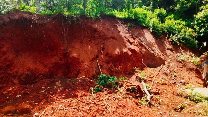
21   Style                    : Single
22   Failure mechanism        : Shallow planar (≤ 5m) failure
23   History                  : Date of initiation: 11th June, 2018 (1400hrs)
24   Geomorphology            : Lowly Dissected Slope, Slide direction is towards N40°E
25   Geology/Lithology        : Pink Granite Gneiss
26   Structure                : -
27   Landuse/ Landcover       : Settlement
28   Hydrological condition   : Wet
29   Triggering Factor        : Rainfall
30   Death of persons         : Nil
31   People affected          : Nil
32   Livestock Loss           : Nil
33   Communication            : Nil
34   Infrastructure           : Newly constructed four storied building completely collapsed.
35   Agriculture/forest/Barren : Nil
36   Geo-scientific Causes    : Construction of building (four storied) in loose overburden material
                                without proper strengthening of foundation which in turn resulted in
                                loading at the head of the slope break. Improper maintenance of
                                drainage system: As the culverts in the road were blocked, the excess
                                water has accumulated besides the building in the road corridor as
                                that part of the road is having a slight depression. This excess water
                                seepage through the loose overburden material increased the pore
                                water pressure which in turn initiated the slide.
37   Remedial measures        : As an immediate remedial measure remove the accumulated remains
                                of collapsed building and the slided materials from the slope, open all
                                the culverts and divert the water through culverts without allowing it
                                to settle in the vulnerable slopes. In future, before initiating any
                                construction, carry out the site feasibility study in order to understand
                                the characteristics of subsoil. Remove and replace the undesirable in
                                situ soil or soil stabilization may be done to improve soil strength and
                                increase the resistance to its softening by water through bonding the
                                soil particles together.
38   Remarks, if any            Another five storied building, situated adjacent to the collapsed
                                building, is in the brim of danger.

                                                                                              7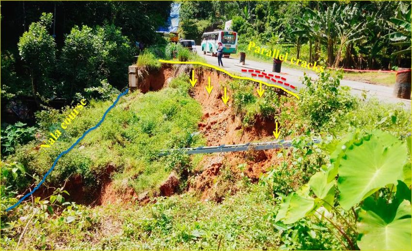
39   Photos. Sketch of Plan & :
     section of the slide

                                                       Fig: The crown of the slide

                                            Fig: Accumulated remains of building and debris.

                                  Fig: A view from the crown of the slide depicts the collapsed building.

                                                                                               8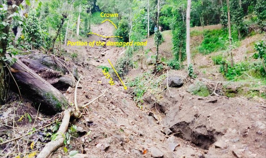
40    Summary/Abstract     : A debris slide occurred in Anachal, Pallivasal Village, Devikulam
                             Taluk, Idukki district at about 1400hrs on 11th June, 2018. Newly
                             constructed four storied building got completely devastated during the
                             slide. The length, width and depth of the slide are about 20m, 30m and
                             3m respectively. The material there was very loose coarse-grained in-
                             situ soil. The slide occurred on a very steep slope of about 60°-70°.
                             The building with its base built on this loose soil added a head
                             loading to the break in slope. All the culverts beside the road were
                             blocked which cause the accumulation of water besides the building in
                             the road corridor. This resulted in increase of pore pressure due to
                             infiltration along the loose overburden material which in turn
                             initiated the slide.
41    Date of Reporting    : 29th June, 2018
42    Landslide Category   : Category II

     Location 3:
No           Field                                       Description
1  Slide No.               : KER/IDK/58F04/2018/03
2     State                : Kerala
3     District             : Idukki
4     Toposheet No.        : 58F/04
5     Name of the slide    : Eetticity
6     NH/SH/Locality       : Anachal-Pothupara road
7     Latitude             : 10.0176 N
8     Longitude            : 77.0472 E
9     Length               : 60m
10    Width                : 50m
11    Height               : 45m
12    Area                 : 3000 m2
13    Depth                : 4m
14    Volume               : 12000m3
15    Run out distance     : 60m
16    Type of Material     : Debris
17    Type of movement     : Slide
18    Rate of movement     : Rapid
19    Activity             : Active
20    Distribution         : Advancing
21    Style                : Single
22    Failure mechanism    : Shallow planar (≤ 5m) failure
23    History              : Date of initiation:09th June, 2018

                                                                                        9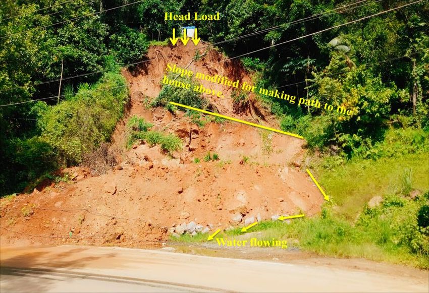
24   Geomorphology             : Lowly Dissected Slope
25   Geology/Lithology         : Pink Granite Gneiss
26   Structure                 : -
27   Landuse/ Landcover        : Settlement, Moderate Vegetation, Slide direction is towards N20°E
28   Hydrological condition    : Wet
29   Triggering Factor         : Rainfall
30   Death of persons          : Nil
31   People affected           : Nil
32   Livestock Loss            : Nil
33   Communication             : Nil
34   Infrastructure            : Nil
35   Agriculture/forest/Barren : Mixed plantations
36   Geo-scientific Causes    : During the construction of a resort in Eetticity, the material
                                removed where collected in more than 100 sacks and the sacks
                                where then loaded in the head of the slope beneath the building.
                                During heavy rain, water seepage through these sacks created
                                increase in pore water pressure together with the weight of the
                                sacks initiate the sliding. The sack surface acted as a non-cohesive
                                surface which in turn increased the possibility of slide.
37   Remedial measures        : As an immediate measure the district authority cover the slided
                                area with polythene sheets which prevented further infiltration or
                                exposure to rain water. Reducing the slope height, reducing the
                                slope angle, removing unstable wash away loose unsorted
                                materials and incorporating benches in the slope.
38   Remarks, if any            -
39   Photos. Sketch of Plan & : -
     section of the slide
40   Summary/Abstract         : A debris slide occurred in Eetticity, Vellathooval Panchayat, Idukki
                                district on 9th June, 2018. The material below a newly constructed
                                resort got slided due to the head loading of slope by the dumped
                                excavated material during the construction of the resort. The
                                length, width and depth of the slide are about 60m, 50m and 4m
                                respectively. The direction of the slide is N20°E with slope angle
                                50°-60°. The material removed during the construction of the resort
                                was dumped in the head portion of the slope in sacks and with the
                                increase in pore water pressure the slide was triggered. As an
                                immediate measure the district authority evacuate the area, closed
                                the resort and covered the slided area with polythene sheets which
                                prevented further infiltration or exposure to rain water.
41   Date of Reporting        : 28th June, 2018
42   Landslide Category       : Category III

                                                                                           10
Location 4:
No Field Description
1 Slide No. : KER/IDK/58G01/2018/04
2 State : Kerala
3 District : Idukki
4 Toposheet No. : 58G/01
5 Name of the slide : Kallimali
6 NH/SH/Locality : Unmetalled road to Ponmudi Reservoir connecting the Adimali-Rajakad
road.
7 Latitude : 09.9509 N
8 Longitude : 77.0795 E
9 Length : 45m
10 Width : 8m
11 Height : 40m
12 Area : 360m2
13 Depth : 7m (approx.)
14 Volume : 2570m3
15 Run out distance : 100m
16 Type of Material : Debris
17 Type of movement : Flow
18 Rate of movement : Very Rapid
19 Activity : Active
20 Distribution : Advancing
21 Style : Single
22 Failure mechanism : Deep planar (≥ 5m) failure
23 History : Date of initiation:09th June, 2018
24 Geomorphology : Moderately Dissected Slope, Slide direction is towards S25°W
25 Geology/Lithology : Charnockite
26 Structure : -
27 Landuse/ Landcover : Moderate Vegetation
28 Hydrological condition : Flowing
29 Triggering Factor : Rainfall
30 Death of persons : Nil
31 People affected : Nil
32 Livestock Loss : Nil
33 Communication : Unmetalled road partly damaged.
34 Infrastructure : Nil
35 Agriculture/forest/Barren : Destroyed 1.5 acre agriculture land (Pepper)
36 Geo-scientific Causes : Pore water pressure, presence of unsorted overburden materials,
unplanned cultivation obstructing the natural course of drainage, slope
modification for the construction of road.
37 Remedial measures : As the area is devoid of any settlements and anthropogenic presence,
removing the unsorted loose overburden and reducing the slope angle
along with proper maintenance of drainage system will serve the
purpose.
38 Remarks, if any -
1139 Photos. Sketch of Plan & :
section of the slide
Fig: A view from the toe of the slide
Fig: A view from the crown of the slide
40 Summary/Abstract : The slide occured in the western slope of Ponmudi reservoir. The slope
and the natural course of the river were modified for cultivation and for
the construction of an unmetalled road. The excavated material after the
formation of road was dumped in the crest of the slope and the incessant
shower prevailed from 08th June, 2018 initiate the sliding. The length,
width and depth of the slide are about 45m, 8m and 7m (approx.)
respectively. The direction of the slide is S25°W with a slope angle
varing from 25°-35°. Smoothening the topography by removing the
unsorted loose overburden material with proper maintenance of
drainage system is the suggested immediate remedial measures.
41 Date of Reporting : 28th June, 2018.
42 Landslide Category : Category III
12Location5:
No Field Description
1 Slide No. : KER/IDK/58G01/2018/05
2 State : Kerala
3 District Idukki (Devikulam Taluk)
4 Toposheet No. : 58G/01
5 Name of the slide : Kallarkutty
6 NH/SH/Locality : Kallarkutty Dam Road
7 Latitude : 09.974 N
8 Longitude : 76.9968 E
9 Length : 8m
10 Width : 9m
11 Height : 20m
12 Area : 72m2
13 Depth : 5m
14 Volume : 360m3
15 Run out distance : 5m
16 Type of Material : Debris
17 Type of movement : Slide
18 Rate of movement : Moderate
19 Activity : Active
20 Distribution : Advancing
21 Style : Single
22 Failure mechanism : Shallow rotational(≤ 5m) failure
23 History : Date of initiation:09th June, 2018
24 Geomorphology : Lowly Dissected Slope, Slide direction is towards S58°W
25 Geology/Lithology : Hornblende biotite Gneiss
26 Structure : -
27 Landuse/ Landcover : Moderate Vegetation
28 Hydrological condition : Flowing
29 Triggering Factor : Rainfall
30 Death of persons : Nil
31 People affected : Nil
32 Livestock Loss : Nil
33 Communication : Kallarkutty dam road blocked for hours.
34 Infrastructure : One house partly damaged.
1335 Agriculture/forest/Barren : Nil
36 Geo-scientific Causes : Pore water pressure, reduction of strength on super saturation,
unplanned construction, loading at head region and excavation of the
slope.
37 Remedial measures : Removal of slided material, smoothening the slope face and
installation of proper drainage conduits/pipes to ooze out the free
flowing water from the surface.
38 Remarks, if any -
39 Photos. Sketch of Plan & :
section of the slide
Fig: Kallarkutty debris slide
40 Summary/Abstract : The debris slide occurred beside the Kallarkutty dam road has
resulted in partial damage to one house and the road was blocked for
hours. The length, width and depth of the slide are about 8m, 9m and
5m respectively. The direction of the slide is S58°W with a slope
angle >45°. During the study it was found that the modification of
slope for making path to access the house is the major preparatory
factor and the excess pore-water pressure developed during incessant
rainfall is the triggering factor. The continuous oozing out of water
from different parts of slide points to the presence of an impermeable
layer below, which resulted in increased pore-water pressure and
decreased shear strength, thus facilitating slope failure.
41 Date of Reporting : 01st July, 2018.
42 Landslide Category : Category III
Location 6:
No Field Description
1 Slide No. : KER/IDK/58C03/2018/06
2 State : Kerala
3 District : Idukki
4 Toposheet No. : 58C/03
5 Name of the slide : Kallarkutty II
6 NH/SH/Locality : Kallarkutty approach road
147 Latitude : 09.9737 N
8 Longitude : 76.9992 E
9 Length : -
10 Width : 30m
11 Height : -
12 Area : -
13 Depth : 3m
14 Volume : -
15 Run out distance : -
16 Type of Material : Soil
17 Type of movement : Subsidence
18 Rate of movement : Rapid
19 Activity : Active
20 Distribution : Moving
21 Style : Single
22 Failure mechanism : Shallow planar (≤ 5m) failure
23 History : Date of initiation:09th June, 2018, 02.00hrs
24 Geomorphology : Valley
25 Geology/Lithology : Hornblende biotite Gneiss
26 Structure : -
27 Landuse/ Landcover : Moderate Vegetation
28 Hydrological condition : Flowing
29 Triggering Factor : Rainfall
30 Death of persons : Nil
31 People affected : Nil
32 Livestock Loss : Nil
33 Communication : Nil
34 Infrastructure : Road side concrete retaining wall
35 Agriculture/forest/Barren : Agriculture (pepper)
36 Geo-scientific Causes : As there was a column of soil between the road and the newly
constructed retaining wall the water perched through the column
resulted in soaking of the material mass & caused increase in weight
along with the pore water pressure created an additional stress towards
the retaining wall. This along with the removal of lateral support due to
erosion by nala initiated the subsidence.
37 Remedial measures : Remove the collapsed retaining wall and loose overburden material.
Construction of concrete reinforced gravity wall with proper drainage
conduits. Proper maintenance of road drainage system through
construction of impermeable side ditches and culverts.
1538 Remarks, if any -
:
Photos. Sketch of Plan &
39
section of the slide
Fig: Subsidence in Kallarkutty approach road.
40 Summary/Abstract : The subsidence occurred beside the Kallarkutty approach road at
1400hrs on 09.07.2018. The subsidence occurred as a result of the toe
erosion by one of the tributaries of Mutira Puzha along with the weight
of the retaining wall constructed beneath the approach road. Some
parallel cracks were also observed in the approach road which will fall
eventually if any retaining wall was not constructed.
41 Date of Reporting : 01st June, 2018
42 Landslide Category : Category III
Location 7:
No Field Description
1 Slide No. : KER/IDK/58B16/2018/07
2 State : Kerala
3 District Idukki
4 Toposheet No. : 58B/16
5 Name of the slide : Cheruthoni
166 NH/SH/Locality : Thodupuzha-Puliyanmala road
7 Latitude : 09.8538 N
8 Longitude : 76.9681 E
9 Length : 6m
10 Width : 15m
11 Height : 9m
12 Area : 90m2
13 Depth : 0.5m
14 Volume : 45m3
15 Run out distance : 2.5m
16 Type of Material : Soil
17 Type of movement : Slide
18 Rate of movement : Rapid
19 Activity : Active
20 Distribution : Advancing
21 Style : Single
22 Failure mechanism : Shallow planar(≤ 5m) failure
23 History : Date of initiation:09th June, 2018
24 Geomorphology : Lowly Dissected Slope
25 Geology/Lithology : Biotite Gneiss
26 Structure : -
27 Landuse/ Landcover : Settlement
28 Hydrological condition : Dripping
29 Triggering Factor : Rainfall
30 Death of persons : Nil
31 People affected : Nil
32 Livestock Loss : Nil
33 Communication : Nil
34 Infrastructure : One house partly affected.
35 Agriculture/forest/Barren : Nil
36 Geo-scientific Causes : The slope was modified for the construction of one house and left
behind the cut slope without construction of any retaining wall.
The weight of the trees at the edge of the excavated slope along
with the infiltration of rain water initiated the movement.
37 Remedial measures : Removal of trees from the edge of the cut slope, removing
material from the area driving the landslide and reducing
general slope angle.
38 Remarks, if any : As water is still dripping out of the failed surface, the chance of
17recurrence is there.
39 Photos. Sketch of Plan & :
section of the slide
40 Summary/Abstract : The slope was modified for the construction of one house and left
behind the cut slope without construction of any retaining wall.
The weight of the trees at the edge of the excavated slope along
with the infiltration of rain water resulted in sliding. As water is
still dripping out of the failed surface, the chance of recurrence
is there. Removal of trees from the edge of the cut slope,
removing material from the area driving the landslide and
reducing general slope angle can slow or stop further sliding.
41 Date of Reporting : 01st July, 2018
42 Landslide Category : Category III
Location 8:
No Field Description
1 Slide No. : KER/IDK/58B16/2018/08
2 State : Kerala
3 District Idukki
4 Toposheet No. : 58B/16
5 Name of the slide : Valara
186 NH/SH/Locality : Valara-Vadakkechal road (By road to NH 49)
7 Latitude : 10.0455 N
8 Longitude : 76.8472 E
9 Length : -
10 Width : -
11 Height : -
12 Area : -
13 Depth : -
14 Volume : -
15 Run out distance : -
16 Type of Material : Rock
17 Type of movement : Fall
18 Rate of movement : Extremely Rapid
19 Activity : Active
20 Distribution : -
21 Style : Successive
22 Failure mechanism :
23 History : Date of initiation:03rd May, 2018,
Date of reactivation:09th June, 2018
24 Geomorphology : Moderately Dissected Slope
25 Geology/Lithology : Biotite Gneiss
26 Structure : -
27 Landuse/ Landcover : High Height Plantation
28 Hydrological condition : Wet
29 Triggering Factor : Rainfall
30 Death of persons : Nil
31 People affected : Nil
32 Livestock Loss : Nil
33 Communication : Nil
34 Infrastructure : Nil
35 Agriculture/forest/Barren : Agriculture (Rubber)
36 Geo-scientific Causes : After site inspection it was concluded that weathering and erosion
have resulted in the development of fractures parallel to the
surface (sheet joints). Over long periods, daily temperature
variations and extreme heat along with water flowing through
fractures decomposes the bedrock, loosened bonds that hold rocks
in place which created large slabs of rock by the process of
exfoliation. Vegetation growth along with the triggering factor of
19rainfall finally forced the unstable rock to fall.
37 Remedial measures : Removal of protrusions and overhangs (exfoliated rock slabs)
retained in the top by scaling (manual or mechanical) if possible.
38 Remarks, if any -
39 Photos. Sketch of Plan & :
section of the slide
40 Summary/Abstract : Two successive rockfalls occurred in Valara on 03rd May, 2018
and 09th June, 2018. A fragment of rock detached by falling along
the sub-vertical ridge faces and proceeded down slope by
bouncing along the thick high height plantations (Rubber) below.
After site inspection it was concluded that weathering and erosion
have resulted in the development of fractures parallel to the
surface (sheet joints). Over long periods, daily temperature
variations and extreme heat along with water flowing through
fractures decomposes the bedrock, loosened bonds that hold rocks
in place which created large slabs of rock by the process of
20exfoliation. Vegetation growth along with the triggering factor of
rainfall finally forced the unstable rock to fall. Removing the
protrusions and overhangs (exfoliated rock slabs) retained in the
top by scaling (manual or mechanical) if possible is the suggested
mitigation measure.
41 Date of Reporting : 02nd July, 2018
42 Landslide Category : Category III
Location 9:
No Field Description
1 Slide No. : KER/IDK/58F04/2018/09
2 State : Kerala
3 District Idukki
4 Toposheet No. : 58F/04
5 Name of the slide : Anaviratty
6 NH/SH/Locality : NH – 49 (Kochi – Dhanushkodi Road)
7 Latitude : 10.0172 N
8 Longitude : 76.9891 E
9 Length : 7m
10 Width : 10m
11 Height : 10m
12 Area : 70m2
13 Depth : 1m
14 Volume : 70m3
15 Run out distance : 3m
16 Type of Material : Soil
17 Type of movement : Slide
18 Rate of movement : Rapid
19 Activity : Active
20 Distribution : Retrogressive
21 Style : Successive
22 Failure mechanism : Shallow planar(≤ 5m) failure
23 History : Date of initiation:09th June, 2018
24 Geomorphology : Moderately Dissected Slope, Slide direction is towards S 70°W
25 Geology/Lithology : Hornblende biotite Gneiss
26 Structure : -
27 Landuse/ Landcover : Thick vegetation, Extensive slope cut for construction of road.
28 Hydrological condition : Wet
2129 Triggering Factor : Rainfall
30 Death of persons : Nil
31 People affected : Nil
32 Livestock Loss : Nil
33 Communication : Road blocked- NH – 49 (Kochi – Dhanushkodi Road)
34 Infrastructure : Nil
35 Agriculture/forest/Barren : Forest
36 Geo-scientific Causes : Unplanned cutting of slope for the construction of NH – 49 (Kochi –
Dhanushkodi Road). Saturation of loose overburden due to incessant
rainfall.
37 Remedial measures : Construction of gabion retaining wall.
38 Remarks, if any Slope failures are common along the road corridors as the roads are
constructed by vertically cutting thick column of old debris/soil mass
and leaving the cut slope untreated making them highly susceptible to
failure.
39 Photos. Sketch of Plan & :
section of the slide
40 Summary/Abstract : A cut slope failure occurred in Anaviratty, Devikulam Taluk, Idukki
district on 9th June, 2018. As a result of the failure the NH – 49 (Kochi
– Dhanushkodi Road) was blocked for hours. The length, width and
depth of the slide are about 7m, 10m and 1m respectively. Part of the
dislodged material was accumulated on the road disrupting the traffic
in Kochi – Dhanushkodi Road. The unplanned cutting of hill slope for
the construction of NH - 49 along with the oversaturation of loose
overburden due to incessant rainfall triggered the slide.
41 Date of Reporting : 29th June, 2018
42 Landslide Category : Category III
22Location 10:
No Field Description
1 Slide No. : KER/IDK/58F04/2018/10
2 State : Kerala
3 District Idukki
4 Toposheet No. : 58F/04
5 Name of the slide : Ambazhachal
6 NH/SH/Locality : Thottapura-Selliampara Road
7 Latitude : 10.0191 N
8 Longitude : 77.0162 E
9 Length : 3.5m
10 Width : 5m
11 Height : 5m
12 Area : 17.5m2
13 Depth : 1m
14 Volume : 17.5m3
15 Run out distance : -
16 Type of Material : Soil
17 Type of movement : Slide
18 Rate of movement : Rapid
19 Activity : Active
20 Distribution : Retrogressive
21 Style : Successive
22 Failure mechanism : Shallow planar (≤ 5m) failure
23 History : Date of initiation:09th June, 2018
24 Geomorphology : Lowly Dissected Slope, Slide flow is towards N 40°W
25 Geology/Lithology : Pink Granite Gneiss
26 Structure : -
27 Landuse/ Landcover : Moderate vegetation, Extensive slope cut for construction of road.
28 Hydrological condition : Wet
29 Triggering Factor : Rainfall
30 Death of persons : Nil
31 People affected : Nil
32 Livestock Loss : Nil
33 Communication : Thottapura – Selliampara Road blocked for hours.
2334 Infrastructure : Nil
35 Agriculture/forest/Barren : Moderate vegetation with settlement.
36 Unplanned cutting of Ambazhachal hill slope for the construction of
Geo-scientific Causes : Thottapura – Selliampara road. Saturation of loose overburden due
to incessant rainfall.
37 Remedial measures : Construction of gabion retaining wall.
38 Slope failures are common along the road corridors as the roads are
constructed by vertically cutting thick column of old debris/soil mass
Remarks, if any
and leaving the cut slope untreated making them highly susceptible
to failure.
39 Photos. Sketch of Plan & :
section of the slide
40 Summary/Abstract : A cut slope failure occurred in Ambazhachal, Pallivasal Village,
Devikulam Taluk, Idukki district on 9th June, 2018. As a result of the
failure the Thottapura-Selliampara road was blocked for hours. The
length, width and depth of the slide are about 3.5m, 5m and 1m
respectively. Part of the dislodged material was accumulated on the
road disrupting the traffic in the Thottapura-Selliampara road. The
unplanned cutting of Ambazhachal hill slope for the construction of
Thottapura - Selliampara road along with the saturation of loose
overburden due to incessant rainfall triggered the slide.
41 Date of Reporting : 29th June, 2018
42 Landslide Category : Category III
24You can also read