Photogrammetric reconstruction of the Roman fish tank of Portus Julius (Pozzuoli Gulf, Italy): a contribution to the underwater geoarchaeological ...
←
→
Page content transcription
If your browser does not render page correctly, please read the page content below
Photogrammetric reconstruction of the Roman fish tank
of Portus Julius (Pozzuoli Gulf, Italy): a contribution to
  the underwater geoarchaeological study of the area.
      Claudia Caporizzo 1§, Pietro P.C. Aucelli 1, Gaia Mattei 1, Aldo Cinque 2, Salvatore Troisi 1, Francesco Peluso 1,
                                          Michele Stefanile 3, Gerardo Pappone 1
                                 1
                           Dipartimento di Scienze e Tecnologie, Università degli Studi di Napoli Parthenope,
                                             Centro Direzionale Is C4, 80121 Napoli, Italy
           2
             Dipartimento di Scienze della Terra, dell’Ambiente e delle Risorse, Università degli Studi di Napoli Federico II,
                                             Largo San Marcellino, 10, 80138 Napoli, Italy
                        3
                          Dipartimento Asia Africa e Mediterraneo, Università degli Studi di Napoli L'Orientale,
                                        Piazza S. Domenico Maggiore, 12, 80134 Napoli, Italy
                                                  §
                                                    claudia.caporizzo@uniparthenope.it

Abstract— This research aims at the 3D reconstruction of a Roman                                              The goal of this study is to provide a detailed 3D reconstruction
fish tank (piscina) located inside the archaeological area of Portus                                      of the nowadays submerged fish tank of the Roman harbor of
Julius (Gulf of Pozzuoli, Naples) and it is part of a wider research                                      Portus Julius.
finalized to reconstruct the amount of the vertical ground movements
(VGM) occurred during historical times in the Gulf of Pozzuoli. The                                           The study site is located inside the Underwater Archaeological
ancient piscina is related to the second life stage of the harbor that,                                   Park of Baia, famous all over the world since in historical time the
after its construction in 37 BC, during the year 12 BC switched its                                       area was affected by sudden VGM that led to the submersion of the
usage from a military to a commercial one. The photogrammetric                                            entire coastal sector. This intense overall subsidence resulted in a
survey of the fish tank, curved directly into the embankment of the                                       perfect preservation status of the structures still clearly
entry channel of the port, has been carried out in order to better                                        recognizable.
characterize its morphological features, since it represents an
important time reference for the area.                                                                       In 37 BC, the area enclosed between the Lucrino and the Averno
                                                                                                          Lakes was chosen by Agrippa for the construction of the new
                        I.      INTRODUCTION                                                              military harbour system of Portus Julius.
     The Gulf of Pozzuoli, located in the wide Campi Flegrei                                                 The military purpose of the system ended in the 12 BC, with the
Caldera, offers the possibility to collect important information                                          conversion of the harbor in a commercial base together with the
about the modification the coastal landscape and the relative sea                                         relocation of the military port in the nearby Misenum, Indeed,
level (RSL) changes related to vertical ground movements (VGM)                                            Portus Julius was rethought and restructured, with the
occurred in historical times. In fact, along the littoral, there are                                      transformation and the adaptation of military environments into
several archaeological remains (maritime villae, harbor facility                                          warehouses. [2, 3, 4].
etc.) scattered along the coast and testifying the ancient occupation
                                                                                                              The fish tank here surveyed can be considered as a good
of the sector. Nowadays the main part of the ancient coastal strip,
                                                                                                          evidence of the renovation occurred after 12 BC. This fish tank is
including all the buildings and maritime structures, is submerged
                                                                                                          particularly interesting because it represents one of the few
due to overall subsidence started at the end of the Roman period
                                                                                                          examples of fish tanks related to commercial activities and not to
[1].
                                                                                                          private maritime villas.
    A multidisciplinary approach made of direct and indirect
                                                                                                              Considering the importance of this feature, together with a
techniques turns out to be really useful for the study of submerged
                                                                                                          direct survey aimed to determine the submersion of its structural
landscapes, since indirect surveys as the photogrammetric one can
                                                                                                          element, a photogrammetric survey of the fish tank has been
provide really accurate morphometric characterization of the
                                                                                                          realized. The photogrammetric reconstruction was crucial both for
underwater features, usually not easily accessible.
                                                                                                          the evaluation of the elements related to the study of the past RSL

                      Claudia Caporizzo, Pietro P.C. Aucelli, Gaia Mattei, Aldo Cinque, Salvatore Troisi, FrancescoPeluso, Michele Stefanile, and GerardoPappone (2020)

                Photogrammetric reconstruction of the Roman fish tank of Portus Julius (Pozzuoli Gulf, Italy): a contribution to the underwater geoarchaeological study of the area:

         in Massimiliano Alvioli, Ivan Marchesini, Laura Melelli & Peter Guth, eds., Proceedings of the Geomorphometry 2020 Conference, doi:10.30437/GEOMORPHOMETRY2020_16.

                                                                                               59
Geomorphometry 2020 Caporizzo and others
and for the documentation of this singular fish tank built for
commercial use, with a great cultural value.
II. METHODS
The fish tank here studied, due to its strategic position,
represented the key element of our geoarchaeological
interpretations in terms of ground movements occurred during the
Roman times. The sluice gate of this fish tank was built directly by
cutting the channel embankment. This led to the assumption that it
was therefore built in the second construction phase of the Portus
Julius, according to Benini and Giacobelli [5]. Therefore, in this
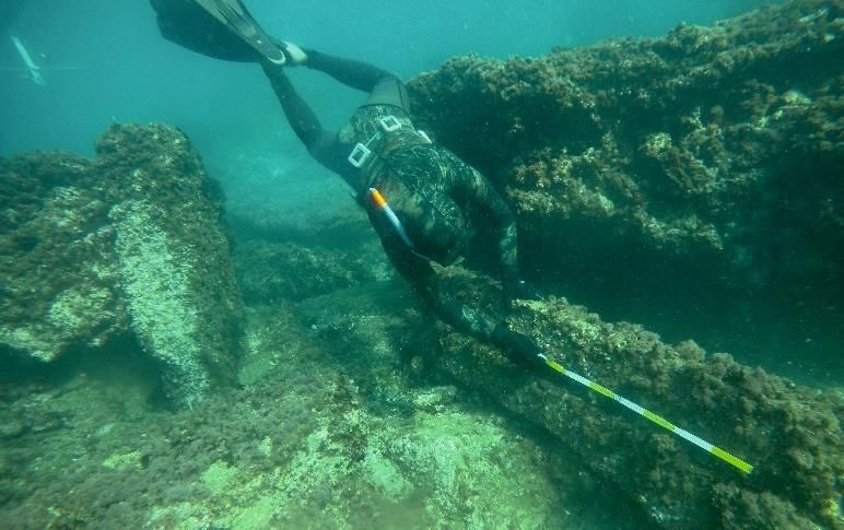
area, an underwater photogrammetric survey (Fig.1) has been
carried out both to obtain a detailed morphometric analysis of this
functional element and to preserve a 3D documentation of this (a) (b)
important and unique historical testimony, also considering the
extreme fragility of this underwater landscape.
The photogrammetric survey was planned by using a
photogrammetric system (Fig. 1a and b) consisting of two high-
resolution cameras, having the optical axis vertical.
The stereoscopic base and the submersion of the system were
chosen in relation to the bathymetry of the study area and to the
resolution of the three-dimensional model of submerged findings
(Fig. 1a). With our setting for the cameras, ensuring a minimum
overlap of 80% for the images during the survey. Taking into
account the characteristics of the video cameras, to ensure a
transversal overlap of at least 80%, the stereoscopic base was
chosen equal to 30 centimeters. The depth of the photogrammetric
system was modified during the survey to guarantee both an (c)
adequate completeness of the three-dimensional model and its
resolution (see Fig. 1c).
As shown in Figure 1a, the camera system was towed by a rope
connected to an emerged float and moved by a diver. This system
provides two basic positions, namely position A at -1 meter and
position B at -2 meters below sea surface.
The photogrammetric 3D model of the surveyed fish tank was
obtained in three two steps [6]:
- The videos at 30 fps recorded by the two Xiaomi cameras
(previously calibrated in an underwater environment close to the
study area to achieve the inner orientation parameters were
synchronized by the use of the trigger system and the images were
extracted using a frame every 6th frame. More than one thousand
1920x1080 images were thus obtained;
(d)
- The alignment procedure of the images and the dense point
cloud extraction was performed by Agisoft Metashape software. Figure 1. (a) Reconstruction of the photogrammetric system used during the
survey; (b) Photogrammetric system used during the survey; (c) Positon of the
The 3D model was not georeferenced because it was not possible
photogrammetric cameras during the survey; (d) Direct measurement of a linear
to determine the coordinates of the control points, but some linear constrain by a diver.
measurements made by the diver directly on the underwater
structure made it possible to scale the dense point cloud.
60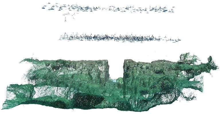
Geomorphometry 2020                                                                                                         Caporizzo and others

       The buddle adjustment procedure has been performed by using
   two linear constraints measured directly by a diver and two more
   distances, used as check in different zones of the sensed fish tank
   [7, 8, 9] (Fig. 1d). The procedure of alignment produced a
   difference of less than 2 cm in each of two distances used as check.
                     III. RESULTS AND CONCLUSIONS
       The triangular fish tanks of Portus Julius, with a size of
   20x22x16 m, is entirely made of tuff and it appears to be carved
   directly into the embankment of the entry channel (Fig. 2).
        During the direct survey the main constructional element of the
   piscina were measured to evaluate the amount of their submersion.                                               (a)
   In particular, the measurements concerned the sluice gate of the tank
   still in situ (cataracta, i.e. closing gate located at the access of the
   channels of the tanks into the basin or at communication passage
   between each tank) [10, 11, 12, 13, 14].
       The top of the sluice was built 0.2 m (functional clearance, fc)
   above the mean high water (MHW), so correcting the submersion
   measurement with respect to this value and the reference water
   level (RWL) of the sea level marker, in this case equal to the half
   of the difference between the MHW and the mean low water
   (MLW), a RSL of -3.10 m MSL for the 12 BC was calculated [14,
   15, 16].
       All the measurements and considerations derived from the                                     (b)                                    (c)
   direct survey have been supported by correlations made on the base
   of the analysis of the 3D photogrammetric reconstruction (Fig. 2a,
   b and c).
       Nowadays the digital photogrammetric techniques have
   reached really high levels due to the new technologies. These
   methods of analysis are becoming more and more common and
   accessible to a growing number of people due to the low cost of
   their realization.
      The use of the photogrammetry falls into different categories,
   even in areas of complex approach as in this case of a 3D
   underwater reconstruction of an element of archaeological interest.
       Considering this research carried out on the Roman fish tank of                                             (d)
   Portus Julius, the results achieved have a meaningful scientific
                                                                              Figure 2. (a) Photogrammetric Point cloud; (b) Zoom of the 3D reconstruction
   value related to the possibility of carrying out precise
                                                                              of the well preserved gate; (c) Zoom of the 3D reconstruction of two perimeter
   measurements of the three-dimensionally reconstructed object. On           walls of the fish tank; (d) 3D sketch of the surveyed fish tank.
   the other hand, the realization of the 3D model offers a virtual
   access opportunity to the element located in a submerged
   environment, normally only open to a specialized public.

                                                                        61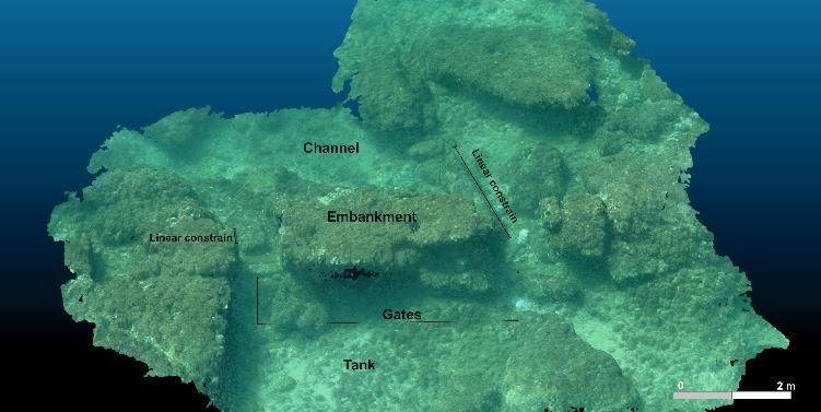
Geomorphometry 2020                                                                          Caporizzo and others

                                      REFERENCES
   [1]    Morhange, C.; Marriner, N.; Laborel, J.; Todesco, M.; Oberlin, C. Rapid
          sea-level movements and non-eruptive crustal deformation in the
          phlegrean Fields caldera, Italy. Geology 2006, 34, pp. 93-96.
   [2]    Benini, A.; Giacobelli, M. Peschiera o Pescheria? Curiosità flegree. Atti del
          III Convegno di Archeologia Subacquea, Manfredonia, Italy, 4-6 ottobre
          2007; Insulae Diomedeae - 24.
   [3]    Miniero, P. Baia sommersa e portus Iulius. Il rilievo con strumentazione
          integrata Multibeam. In Ricoveri per navi militari nei porti del Mediterraneo
          antico e medievale; Blackman, D. J., Lentini, M. C., Bari, Italy, 2010; pp.
          101-108.
   [4]    Gianfrotta, P.A. Ricerche nell’area sommersa del “Portus Iulius” (1988-’90 e
          successive): un riepilogo. In ATTA 22, 2012; pp. 1-20.
   [5]    Benini, A.; Giacobelli, M. Peschiera o Pescheria? Curiosità flegree. Atti del
          III Convegno di Archeologia Subacquea, Manfredonia, Italy, 4-6 ottobre
          2007; Insulae Diomedeae - 24.
   [6]    Mattei, G.; Troisi, S.; Aucelli, P.P.C.; Pappone, G.; Peluso, F.; Stefanile, M.
          Multiscale reconstruction of natural and archaeological underwater landscape
          by optical and acoustic sensors. In 2018 IEEE International Workshop on
          Metrology for the Sea; Learning to Measure Sea Health Parameters
          (MetroSea), 2019b; pp. 46-49.
   [7]    Marre, G.; Holon, F.; Luque, S.; Boissery, P.; Deter, J. Monitoring Marine
          Habitats With Photogrammetry: A Cost-Effective, Accurate, Precise and
          High-Resolution Reconstruction Method. Front. Mar. Sci. 2019; 6:276. doi:
          10.3389/fmars.2019.00276
   [8]    Neyer, F.; Nocerino, E.; Gruen, A. IMAGE QUALITY IMPROVEMENTS
          IN LOW-COST UNDERWATER PHOTOGRAMMETRY, Int. Arch.
          Photogramm. Remote Sens. Spatial Inf. Sci., XLII-2/W10, 135–142,
          https://doi.org/10.5194/isprs-archives-XLII-2-W10-135-2019, 2019.
   [9]    Pierre Drap (2012). Underwater Photogrammetry for Archaeology, Special
          Applications of Photogrammetry. Dr. Daniel Carneiro Da Silva (Ed.), ISBN:
          978-953-51-0548-0,                InTech,           Available             from:
          http://www.intechopen.com/books/special-applications-of-
          photogrammetry/underwater-photogrammetry-forarchaeology
   [10]   Leoni, G.; Dai Pra, G. Variazioni del livello del mare nel tardo olocene, ultimi
          2500 anni, lungo la costa del Lazio in base ad indicatori geo-archeologici:
          interazioni fra neotettonica, eustatismo e clima. ENEA, Unità comunicazione
          e informazione, 1997.
   [11]   Lambeck, K.; Anzidei, M.; Antonioli, F.; Benini, A.; Esposito, E. Sea level
          in Roman time in the central Mediterranean and implications for recent
          change. EPSL 2004, 224, pp. 563–575.
   [12]   Auriemma, R.; Solinas, E. Archaeological remains as sea level change
          markers: a review. Quat. Int. 2009, 206 (1), pp. 134-146.
   [13]   Evelpidou, N.; Pirazzoli, P.A.; Saliegec, J.F. Submerged notches and doline
          sediments evidence for Holocene subsidence. Cont. Shelf Res. 2011., 31, pp.
          1273-1281.
   [14]   Lambeck, K.; Anzidei, M.; Antonioli, F.; Benini, A.; Verrubbi, V. Tyrrhenian
          sea level at 2000 BP: evidence from Roman age fish tanks and their
          geological calibration. Rend. Lincei-Sci. Fis. 2018, 29, pp. 69-80.
   [15]   Shennan, I.; Long, A. J.; Horton, B. P. Handbook of sea-level research.
          Oxford: John Wiley & Sons, New York, U.S.A., 2015.
   [16]   Vacchi, M.; Marriner, N.; Morhange, C.; Spada, G.; Fontana, A.; Rovere, A.
          Multiproxy assessment of Holocene relative sea-level changes in the western
          Mediterranean: Sea-level variability and improvements in the definition of
          the isostatic signal. Earth-Sci. Rev. 2016, 155, pp. 172-197.

                                                                                       62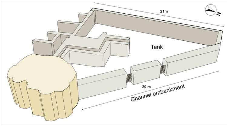

You can also read