National Freshwater Ecosystem Priority Areas
              Project (NFEPA)
←
→
Page content transcription
If your browser does not render page correctly, please read the page content below
National Freshwater Ecosystem Priority Areas
Project (NFEPA)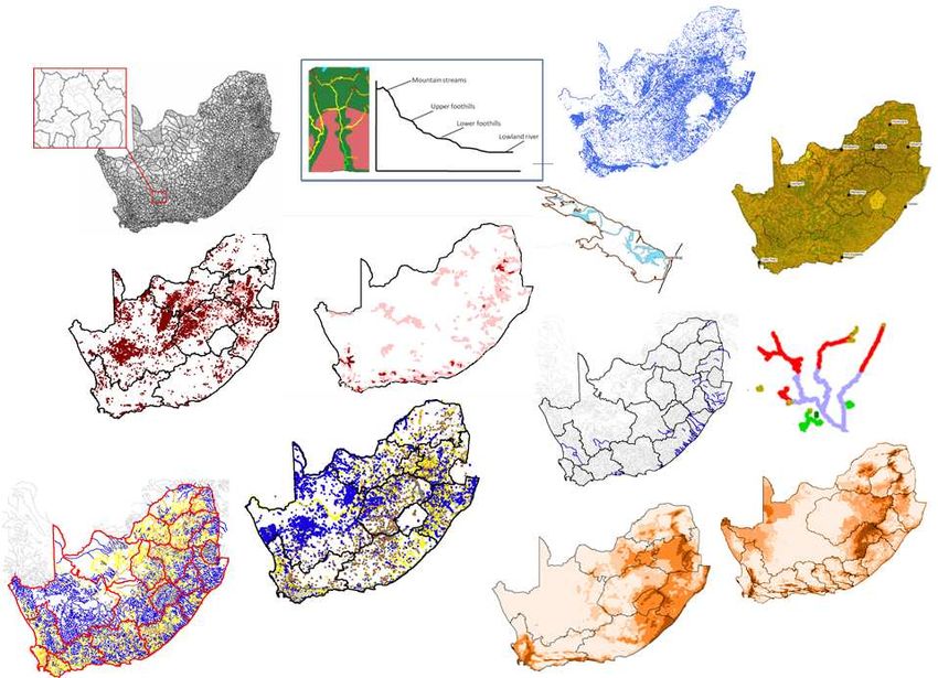
Freshwater ecosystems are in a shocking state
(Driver et al. 2005; Nel et al. 2007)

                                        •   Present ecological status 1999
                                             • Only 30% intact (Class A or B)
                                        •   River Health Programme
                                             • Ongoing deterioration over a 12
                                                                                  year period
                                        •   National Spatial Biodiversity
                                            Assessment
                                             • 84% threatened, 50% critically
                                                                             60
                                                                                     53
                                                                             50

                                             Nu mber o f river sign atures
                                                                             40
                                                                                            32
                                                                             30
                                                                                                                    22
                                                                             20
                                                                                                              13
                                                                             10

                                                                              0
                                                                                     CE      E                V     LT
                                                                                            Con servatio n status

            HOW DO WE MANAGE OUR WATER RESOURCES
                      MORE SUSTAINABLY?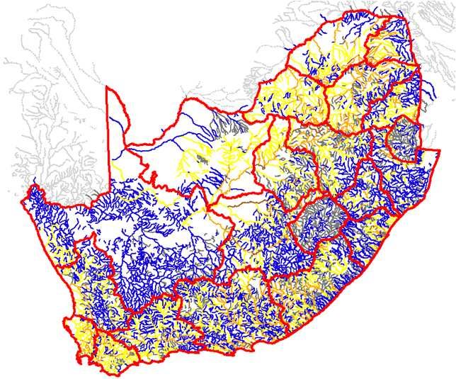
Sustainability:
Balancing protection and utilization
                          •   Protection & utilization
                              work hand-in-hand
                          •   Catchments can be
                              designed for multiple levels
                              of use
                          •   Natural rivers support
                              sustainability of hard
                              working rivers
  Which rivers, and how
                          •   This concept is firmly
  many, are needed in a
                              embedded in SA water
      natural state?
                              policy
SYSTEMATIC BIODIVERSITY
      PLANNING

      also known as

“Systematic Conservation
       Planning”
What is systematic biodiversity planning?

                Biodiversity planning identifies strategic
              spatial priority areas for conservation action
  •   Strategic                            Margules & Pressey 2000 Nature

       •   Strives for efficiency
       •   Proactive use of limited resources (money, capacity)
  •   Systematic
       •   Strives for representation of the full variety of freshwater ecosystems in a
           planning region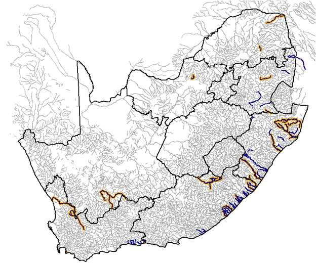
Systematic biodiversity planning
 •   Pioneered in terrestrial ecosystems

                                    1970s
                                     until
         Ad hoc approaches

                                    1980s
         Scoring approaches

                                    1990s
     Planning for representation                SYSTEMATIC
                                                 Biodiversity
                                                  planning:

                                    1990s
       Planning for persistence

                                     2000s   representation + targets
     Planning for implementation                  + persistence
                                                     + policy
                                     2000s

     Planning for climate change
             adaptation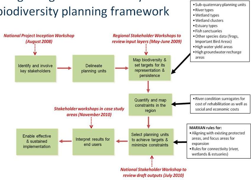
Principles of systematic biodiversity
planning
   •   Representation (Margules & Pressey 2000)
        • Requires and operational means of mapping biodiversity
        • Use “biodiversity surrogates”
        • Scale-dependent (global, regional, national, local)
   •   Setting of quantitative biodiversity targets (Desmet & Cowling 2004)
        • How much of each biodiversity surrogate is enough
        • Should be based in strong science
        • Failing that, agreed-upon policy targets can be very powerful
   •   Persistence (Rouget et al. 2006; Nel et al. 2011)
        • We need to make sure that the processes that maintain the biodiversity
            are still functional
        •   Especially the landscape ones that operate over the large spatial areas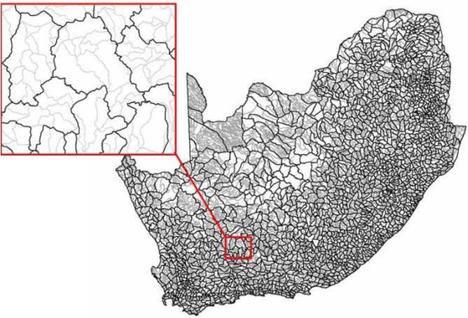
“Implementation principles”
Increased applicability of systematic
biodiversity planning to freshwaters
  •   Focus on entire landscape, NOT JUST PROTECTED
      AREAS
      •   Can design a catchment for different levels of use
      •   Includes people rather than fencing off and locking
          resources away
  •   Focus shifting from ‘representation’ to
      ‘representation + persistence’
      •   Increased attention connectivity over large areas
      •   Ability to incorporate this into conservation planning
          algorithms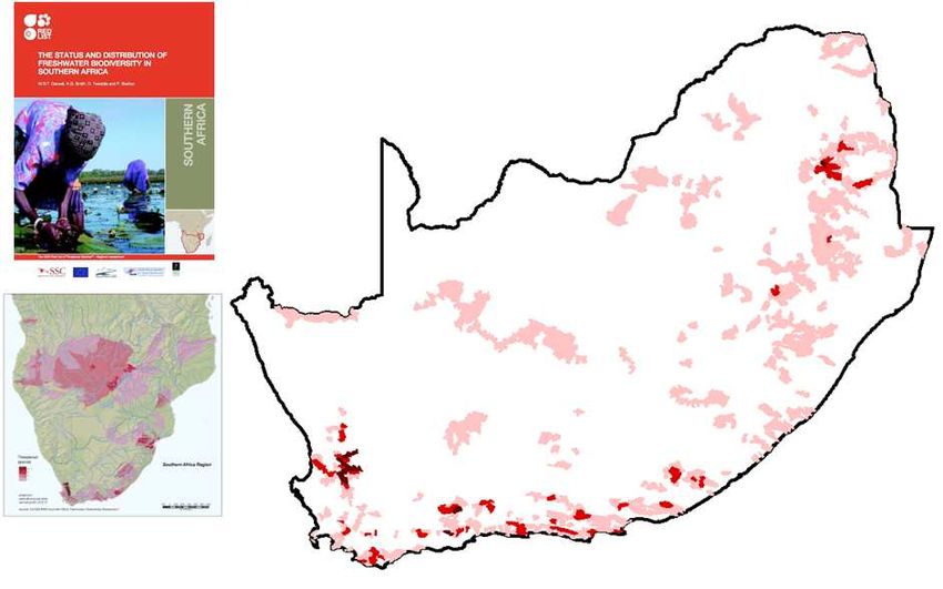
Freshwater biodiversity planning
 Sub-catchment                        Freshwater biodiversity Decision support tools
 delineation with                     surrogates                        for longitudinal
                                      • Higgins et al. 2005 Cons. Biol.
 river-tree networks                  • Snelder et al. 2007 Cons. Biol. connectivity
 HydroSHEDs                           • Turak et al. 2007 Hydrobiologia        • Linke et al. 2007 Freshwater Biol.
 ArcHydro                             • Ausseil et al. 2010 Freshwater Biol.   • Moilanen et al. 2008 Freshwater Biol.
                                                                               • Linke et al. marxan

                                              Policy frameworks
Reviews & case studies                        showing relevance
                                                                                  ......Conservation
• Thieme et al. 2007 Biol. Cons.              within Integrated
• Sowa et al. 2007 Ecological Monographs                                          targets?
• Nel et al. 2009 Aquatic Conservation        Water Resources                     • Roux et al. 2008 Cons. Biol.
• Linke et al. 2010 Freshwater Biol.                                              • Rivers-Moore 2010 WRC Report
• Freshwater Biol. Special Issue 2011         Management
                                              • Roux et al. 2008 Cons. Biol.
HISTORY OF FRESHWATER
BIODIVERSITY PLANNING IN
SOUTH AFRICAFreshwater conservation planning in SA
Noble 1959 O’Keeffe 1986
• 30 aquatic biotopes
• Descriptive (not spatially explicit) • Based on areas experts know well
• Final sites well-known by experts; not • “Until we can classify our rivers zones in
systematic detail, management of different priorities will
• Limited to 30 sites at best be haphazard”
• Not systematic
Aquatic Expert
biotopes opinion
Freshwater
Skelton 1995 Ecosystem Priority
• Systematic Areas• 2011
Systematic and most comprehensive at this
• Based on fish species only scale in the world
• Fish are not good biodiversity surrogates for • Ecosystems and fish, water birds and frogs
invertebrates • Broader species data not included
• Concerted effort for improving ecosystem
condition needed
River types
Wetland types
Fish spp Estuary types
Fish spp
Estuary sppStudies forming the foundation for
NFEPA
• Science
• Ecoregions (Kleynhans et al. 2005)
• Geomorphic zones (Rowntree & Wadeson 1999)
• Fish database & IUCN assessment (SAIAB and Albany Museum; Darwall et al. 2009)
• National land cover (van den Berg 2008)
• Wetland classification (typing) framework (SANBI 2009)
• Case studies
• Policy
• Integrated environmental flow assessment (King & Brown 2010; Brown & King 2010)
• Water Resource Classification system (Dollar et al. 2010)
• National Spatial Biodiversity Assessment (Driver et al. 2005; Nel et al. 2007)
• Cross sector policy process for conserving freshwater ecosystems (Roux et al. 2006)National
Freshwater Ecosystem Priority Areas
Project
(NFEPA)NFEPA Aims
1. To identify National Freshwater Ecosystem Priority
Areas
2. To develop an institutional basis to enable effective
implementation
• National component - aligning water & environment sector
policy mechanisms
• Sub-national component - building capacity to use products
at catchment levelsCo-production of knowledge Collective experience of almost 1000 years!
NFEPA project outputs
1.   Atlas and NFEPA DVD: packages map products and
     data
2.   Implementation manual: how to use FEPA maps in
     existing planning and decision-making processes, along
     with freshwater ecosystem management guidelines
3.   Technical report: documents science and stakeholder
     engagement process
4.   GIS data and associated metadata: in shapefile
     format
Criteria to ID FEPAs
• Represent river, wetland and
estuary ecosystem types
• Represent threatened fish
• Represent free-flowing rivers
• Represent NB migration routes
• Fish corridors
• Wetland clusters
• Maintain water supply areas
• High water yield areas
• High groundwater recharge areas
• Represent estuary species
• Identify connected systemsIntegrating criteria into a systematic biodiversity planning framework
Input data                         River types
                                                          Wetland
                                                          delineations
             Sub-quaternaries
                                                                                Landforms

                                                             Estuaries
                                Fish sanctuaries
 Wetland clusters

                                                        Free-flowing rivers     Wetland
                                                                                types

River condition
                                                   Groundwater recharge

                        Wetland condition                                     Water yield (MAR)
Planning units: nested sub-quaternary catchments
• Quaternaries
Average size ~650 km2
WARNING: There a few ugly ones
• Sub-quaternaries 9,417 • Flat sub-catchments
Average size ~135 km2 • Coastal/estuarine sub-catchmentsRiver types • 31 Level 1 Ecoregions • 4 longitudinal zones • 2 flow regime categories
River condition
   A or B
                  COMBINED:
   C
   D
                  •   DWA Present
   E
                      Ecological State
   Z                  data (1999)
                  •   DWA PES updates in
                      certain regions
                  •   River Health
                      Programme data
                  •   Reserve data
                  •   Modelled land
                      cover data
                  •   Expert opinion
Wetland types National Wetland Classification System, LEVEL 4 (Ollis et al., 2009) 1. Seep 2. Valley-head seep 3. Channelled valley-bottom 4. Unchannelled valley-bottom 5. Floodplain 6. Depression 7. Flat
Landforms for South Africa
Van Deventer et al., in prep

  •    Small neighbourhood
         •   average valley-width for Partridge et al. (2010)
             geomorphic province (plus 1 km)
  •    Large neighbourhood
         •   Maximum width of tertiary catchment (plus 1 km)
Wetland types
• Combine 7 HGM types
with 133 vegetation
type groupings
(“wetveg types”)
• Azonal/Forest lumped
into neighbouring
vegetation
• Each wetland unit
assigned its majority
“wetveg type”
• 792 wetland typesWetland condition
• Used to rank the relative importance of a wetland
CONDITION OF NON-RIVERINE WETLANDS
• Based on the minimum % natural land cover in and
around the wetland:
• Wetland
• 50 m area around a wetland
• 100 m area around wetland
• 500 m area around wetland
CONDITION OF RIVERINE WETLANDS
• The condition of the river is also considered
• If river condition is D, E or F
wetland condition is D, E or F
• If river condition is A, B, C or unknown
wetland condition is based on minimum
% natural landcover in and around the wetlandWetland condition AB – intact wetland C – riverine wetland with associated C river DEF – riverine wetland with associated D, E or F river Z1 – not intact and based on % natural land cover Z2 – majority of wetland unit “Artificial” Z3 - “Artificial” from CDSM
Wetland ranks
  CRITERION                                                                                 RANK
  Wetlands that intersect with a Ramsar site                                                   1
  Wetlands within 500 m of a IUCN threatened frog point locality                               2
  Wetlands within 500 m of a threatened waterbird point locality                               2
  Wetlands (excluding dams) with the majority of its area within a sub-quaternary catchment    2
  that has sightings or breeding areas for threatened Wattled Cranes, Grey Crowned Cranes
  and Blue Cranes
  Wetlands (excluding dams) within a sub-quaternary catchment identified by experts at the     2
  regional review workshops as containing wetlands of exceptional biodiversity importance,
  with valid reasons documented
  Wetlands (excluding dams) within a sub-quaternary catchment identified by experts at the     2
  regional review workshops as containing wetlands that are good, intact examples from which
  to choose
  Wetlands (excluding dams) within a sub-quaternary catchment identified by experts at the     3
  regional review workshops as containing wetlands of biodiversity importance, but with no
  valid reasons documented
  Wetlands (excluding dams) in A or B condition AND associated with more than three other      4
  wetlands (both riverine or non-riverine wetlands were assessed for this criterion)
  Wetlands in C condition AND associated with more than three other wetlands (both riverine    4
  or non-riverine wetlands were assessed for this criterion)
  Wetlands (excluding dams) within a sub-quaternary catchment identified by experts at the     5
  regional review workshops as containing impacted Working for Wetland sites
  Any other wetland (excluding dams)                                                           6
Wetland clusters
          Clusters of wetlands embedded in a relatively
        natural landscape matrix through which dispersal
                   between wetlands can occur
 •   Clusters are a biodiversity feature IN
     ADDITION to representing wetland
     types
 •   More than 3 non-riverine wetlands
     within 1 km of each other where:
      • > 50 % of the wetland systems
          are natural,
      • the landscape matrix is ≥ 25%
          natural
            • Preferential selection first
              from ones with ≥ 50 %
 •   Strive for representation across
     wetland vegetation groups
Fish sanctuaries
• To support the fish sanctuaries, we have identified:
• Upstream Management Zones
• Fish Migration Corridors
• Translocation Zones
• Restoration Zones
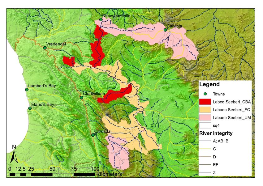
Critical Biodiversity Area
Upstream Manage Zone
Fish migration corridor
Sub-quat catchmentBiodiversity targets
• River ecosystem types – 20% of total length per type
• Wetland ecosystem types – 20% of total area per type
• Threatened freshwater fish species – 100% of all confirmed
Critically Endangered or Endangered populations; at least 10
populations of all other threatened
• Wetland clusters – 20% of total area per “wetveg type”
• Free-flowing rivers – 20% of total length per ecoregion group
• Estuary ecosystem & habitat types – 20% of total area per type
• Estuary-dependent species – 50% of the population of
threatened species; 40% of the population of exploited species; 30%
of the population of all other species
• Non-threatened freshwater fish species
• No a priori target
• where there are less than 10 populations after other FEPAs
selected, additional areas will be chosenPlanning protocol Wetlands
7. Discount sub-catchments
Rivers containing focus areas for
1. Load data into MARXAN protected area expansion AND
• Allows planning for connectivity river FEPAs
2. Select all fish sanctuaries 8. Set boundary cost to favour
• Irrespective of river condition longitudinal connectivity
• But only allow A or B rivers to 9. Run MARXAN to achieve
contribute to river type targets remaining targets for:
3. Discount sub-catchments • Wetland types, wetland clusters
containing focus areas for • Preferential selection in top
protected area expansion wetland ranks
4. Set boundary cost to favour 10. Select wetland units within sub-
longitudinal connectivity catchments selected by MARXAN
5. Run MARXAN to achieve • Exclude dams & wetland rank = 6
• Cut wetland units using sub-
remaining targets for: catchment boundary
• River types, Free-flowing rivers
11. Add in Freshwater Ecosystem
6. Add in Freshwater Ecosystem Support Areas
Support Areas • Sub-catchments containing FEPAs
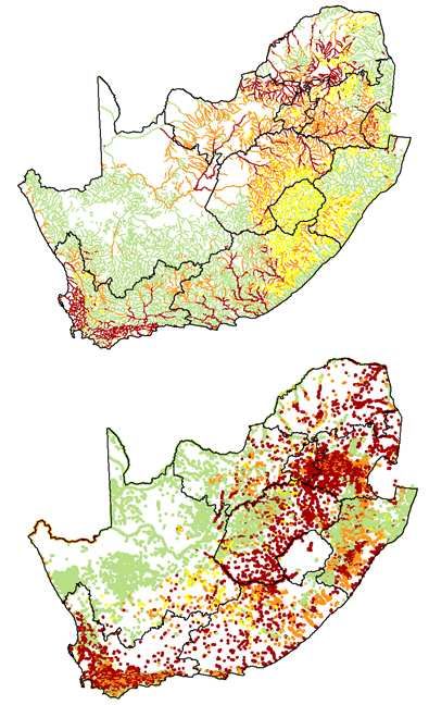
get selected as FESAsNFEPA map products
• WMA level
1. FEPA map (Freshwater Ecosystem Priority Areas)
• National level
2. Density of FEPAs by Water
Management Area
3. Density of FEPAs by sub-Water
Management Area
4. Free-flowing rivers
5. Fish sanctuary areas
6. Water supply areasMAP 1: FEPA map (one for each WMA)
• Incorporating a conservation
vision into Catchment
Management Strategies
• Biodiversity sector input into
scenario planning in water
resource classification
• Planning by national &
provincial conservation
agenciesBiodiversity planning outputs underpinning map products River FEPAs Wetland FEPAs
MAP 2: Density of FEPAs per WMA

                          • Biodiversity
                            responsibility
                            not equal across
                            country
                          • What
                            mechanisms
                            support
                            implementation
                            of biodiversity
                            goals
MAP 3: Density of FEPAs per sub-WMA
• Biodiversity
responsibility
not equal within
a WMA
• What
mechanisms
support
implementation
of biodiversity
goals in the
WMAMAP 4: Free-flowing rivers
Free-flowing rivers
Flagships • 63 rivers
• Only 4% of our
river length
• Only 25 ≥ 100 km
• FLAGSHIPS
• Acknowledge
need for some
developmentNORTHERN CAPE EASTERN CAPE KWAZULU-NATAL
Upper Sak, Klein- Sak & tributaries* Riet Mzimkhulu*
Kap Mzumbe
WESTERN CAPE Mpekweni Mpambanyoni*
Doring & tributaries* Mgwalana aMahlongwa
Klaas Jaagers Kobonqaba aMahlongwana
Rooiels iNxaxo Mkomazi & tributaries*
Touws Qhorha & tribuntaries* Mkuze & tributaries*
Karatara-Hoekraal Shixini Nsuze* tributary of Thukela
Homtini Nqabarha* Matigulu & tributaries*
Knysna Ntlonyane Black Mfolozi & tributaries*
Bietou-Palmiet Xora* Nsonge
Groot Mncwasa Nondweni
Bloukrans Mdumbi Ngogo
Mtakatye* Mfule*
LIMPOPO Mnenu Nyalazi*
Mutale-Luvuvhu* Sinangwana
Mohlapitse Mngazana MPUMALANGA
Mntafufu Ntombe tributary of Phongolo
NORTHWEST Mzintlava Hlelo*
Upper Groot-Marico Mkozi Upper Vaal*
Msikaba* Elands*
Mtentu* Mbyamiti
Sikombe Nwanedzi-Sweni*
Mpahlane
Mzamba*
Mtamvuna & tributaries*
Kraai & tributaries*MAP 5: Water Supply Areas
• High water yield areas
3 x higher than
average for
catchment
• High groundwater
recharge areasMAP 6: Fish Sanctuary Areas
• Number threatened species per
sub-quaternaryKey findings
• Tributaries are in a better condition than main rivers
• Rivers, wetlands and estuaries are highly threatened
• Respectively 57%, 65% and 82% are threatened
• Freshwater Ecosystem Priority Areas (FEPAs) comprise
only 22% of South Africa’s 1:500 000
• There are only 62 large free-flowing rivers,
representing only 4% of our river length
• Only 18 % of our water supply areas are formally
protected
• By protecting only 15% of our river length we protect
all our fish on the brink of extinctionKey messages
1. Freshwater Ecosystem Priority Areas are a valuable
national asset
2. Freshwater inputs are critical to estuarine and marine
environments
3. Free-flowing rivers are part of our natural heritage
4. Healthy tributaries and wetlands support the
sustainability of hard-working rivers
5. Healthy buffers of natural vegetation mitigate the
impact of land-based activities
6. Groundwater sustains river flows particularly in dry
seasons
7. Mountain catchment areas play a critical role in securing
our water supplies
8. Healthy freshwater ecosystems support resilience and
adaptation to climate changeKey recommendations
• Employ aquatic ecologists in provinces, Catchment Management
Agencies and municipalities
• Set up mechanisms to support uptake of FEPA maps, especially by
provincial conservation authorities and Catchment Management
Agencies.
• Use FEPA maps in assessing EIA applications, in water resource
development processes, and in applications for mining and prospecting
• Pilot formal mechanisms for the management and protection of FEPAs
• Revive the Mountain Catchment Areas Act,
• Review general authorisations of the National Water Act in relation to
their impact on FEPAs.
• Strengthen and expand the scope of the River Health Programme to
include wetlands and actively target FEPAs as new monitoring sites.
• Strengthen collaboration of DWA and DEA around managing and
conserving freshwater ecosystems.POLICY CONTEXT
Policy context:
The shared mandate for freshwater biodiversity

                                                  •   FEPAs are the
                                                      biodiversity sector’s
                                                      input into DWA-led
  Mandate for                     Mandate for         water resource
    water:                        biodiversity:       planning and
 Department of                    Department          management
 Water Affairs                   of Env Affairs   •   Talks to both the Water
                                                      and Biodiversity Act
                                                  •   Provides a strategic
                                                      framework for DWA
                                                      and DEA engagement
                                                      around managing &
                                                      conserving freshwater
             Shared mandate for                       ecosystems
           freshwater biodiversity
BIODIVERSITY POLICY CONTEXT
(Protected Areas Act
& Biodiversity Act)BIODIVERSITY GOALS
• Representation
• Persistence
Protected Areas Act
Biodiversity Act
STRATEGY 2
STRATEGY 1
Conservation of
Expand and consolidate
ecosystems in priority
protected area
areas outside the PA
network
network
Range of new tools, including…
• Listing threatened ecosystems
• Listing threatened species
• Bioregional plans
• Biodiversity management plans
• IAS regsListing threatened ecosystems
Rivers 50
43
% Number ecosystem
40
30 26
types
19
20
13
10
0
CR EN VU LT
Wetlands 50 48
% Number ecosystem
40 35
30
types 20
12
10
5
0
CR EN VU LTBioregional plans
planning tools, frameworks, assessments etc
Systematic Biodiversity Plan IDPs
(usually provincial)
Map of SDFs
Critical Biodiversity Areas
Multi-sectoral
(CBAs)
EMFs
Bioregional Plans
NFEPA feeds into (e.g. at district SEAs
provincial level)
biodiversity plans
and CBA maps
EIAs
New ones in
WRCS CMSs future?WATER POLICY CONTEXT (National Water Act)
NFEPA provides biodiversity sector input on:

   • How many rivers, wetlands and estuaries should
     be designated for high protection?
   • Which are best suited for conservation purposes?

            Freshwater Ecosystem
            Priority Area

(E.g. hard-working Vaal River needs healthy
tributaries to sustain the ecosystem services it
provides – how many and which ones?)
Integrated Water Resources Management in SA (National Water Act)
Water Resource Classification
  • Sets a ‘Class’ for every significant water resource through
      consultation
  •   The class defines management objectives for the water
       • Describes the desired condition of the resource & extent to which it can be utilised
  •   Three classes
       • CLASS I: minimally used
       • CLASS II: moderately used
       • CLASS III: heavily used
  •   There are guidelines on the required configuration of ecological
      categories within a catchment for achieving the assigned class
You can also read