Quays and Wharves of Ipswich - IMT Occasional Series of Papers - No 1 Revised and updated 2020 Stuart Grimwade - Ipswich Maritime Trust
←
→
Page content transcription
If your browser does not render page correctly, please read the page content below
Quays and Wharves
of Ipswich

IMT Occasional Series of Papers – No 1
Revised and updated 2020
Stuart Grimwade

June 2020
Quays and Wharves of Ipswich
The first edition of this Paper, published in 2011, was in part designed to encourage all
those involved in the future redevelopment of Ipswich’s historic Waterfront to
recognise the importance of the old quay names, and of the need to reinstate them in
their rightful locations, in preference to new and entirely irrelevant names of no local
significance.
Following Ipswich Borough Council’s welcome decision to reinstate some of those
original quay names utilising those adopted during the early years of the Post Office,
and still officially recognised today, it now seems appropriate to update the Paper. A
new appendix has therefore been added to include some more recent research carried
out by Trust colleagues into earlier quay names often reflecting the names of the
maritime trader property owners or tenants around the Waterfront in earlier times. The
opportunity has also been taken to correct some factual errors in the original paper.
Illustrations are from the Trust image archive.
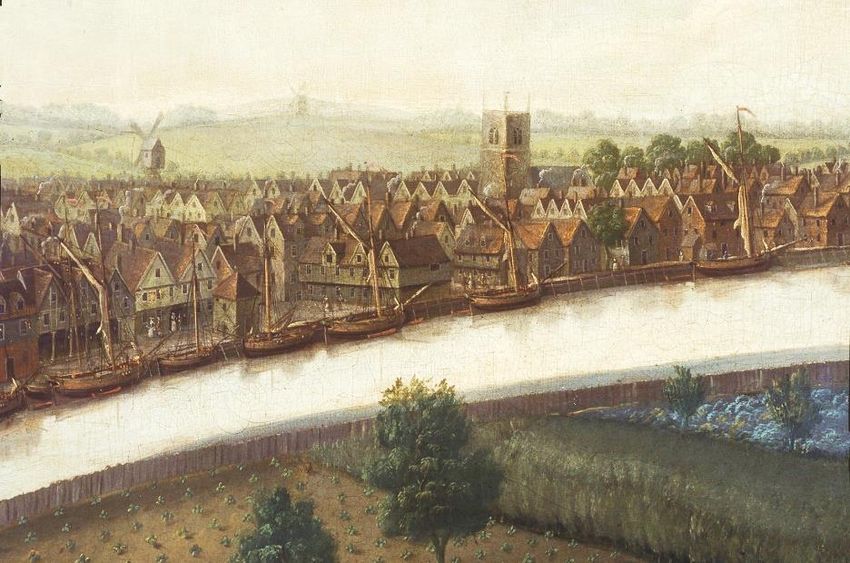
Before the construction of the Wet Dock in 1839 - 42 there was only one place at which it was
legal to land cargoes, and that was the Common Quay in front of the old timber-framed Custom
House with its ‘Sailors’ Walk’ lined with wooden columns supporting the upper floor. The
overall scene was beautifully captured by the artist John Cleveley in the grand panorama from
Stoke Hill which he painted in 1753, a detail of which is reproduced here.
The Common Quay, with
its crane, first mentioned
in 1477, was the place at
which merchants could
load and unload goods
under the eye of the
customs officials. Here is
a view of the back of the
old Custom House.
Elsewhere along the riverside buildings came
right down to the water’s edge, though at the rear of their properties some prominent
merchants had their own quays at which they might deal with their own goods. An early
example of such a private establishment was Bigod’s Quay, owned by the Bigod earls of
Norfolk whose stone house – a mark of great affluence in a town that was largely composed
of timber-framed buildings – stood in Key (Quay) Street.
Isaac Lord's is a complete merchant's establishment with the dwelling house on Fore Street
and storage and processing facilities stretching all the way to the quay. The Smarts, father
Richard and then son William (died 1599), had similarly impressive premises opposite the
Quay church until the final demolition of 1954. Indeed, Bigod's Quay probably became Smart's
Wharf in Elizabethan times. Leonard Squirrell's watercolour reproduced below left, shows the
impressive north-facing gatehouse just before its end. The right hand sketch, by local architect
John Shewell Corder, shows the Wet Dock frontage yard of the same wharf, looking north as
it appeared in the late 19th Century.
Page 2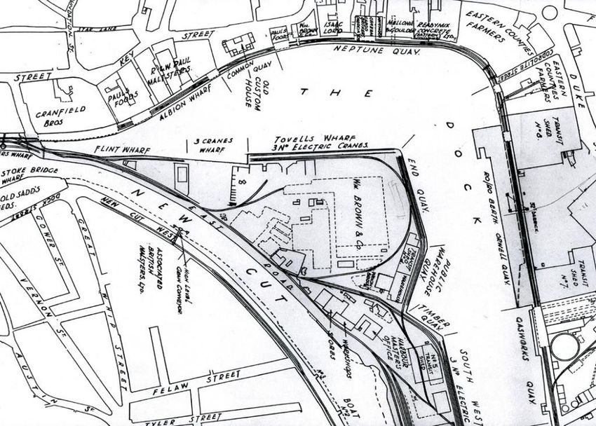
This photograph by local photographer
                                                     William Vick, shows yet another Tudor
                                                     set of wharfside buildings, believed to
                                                     have been demolished for the
                                                     construction of Cranfields Mill, now the
                                                     site of the Trust’s Window Museum.

                                                     It is sad to realise that much of the best
                                                     of Tudor Ipswich dockland was lost in
                                                     relatively recent times. Had they
                                                     survived, these ‘historic waterfront’
                                                     buildings really would enable the area to
                                                     live up to its name.

When Henry Palmer designed the Wet Dock, cutting off a section of the Orwell by damming it
top and bottom and forming the New Cut to carry the waters of the Gipping to the sea, he
proposed the construction of a continuous quay all the way along the north and east sides of
the Dock. In fact for reasons of economy the quay was cut short on the east side at what was
then known as the Ballast Wharf, and from there to the lower dam there was merely a slope into
the water. Even in later times there were only timber stages at the far end, as may be seen in
this early (1858) photo by Robert Burrows:

                                            The Ballast Wharf was the place at which sailing
                                            ships could take on ballast, gravel dredged from
                                            the river, should they be leaving the port without
                                            cargo. Until the establishment of the Dock
                                            Commission the provision of ballast was the sole
                                            and very profitable prerogative of the town’s
                                            Corporation.

                                            Unsurprisingly the place where ballast was loaded
                                            changed from time to time; at the time the Dock
                                            was under construction it was just to the north of
                                            the gasworks, but it later moved to the river side of
                                            the lower dam and then on to the island, just inside
                                            the original lock, and where this photograph was
                                            taken.

                                                                                         Page 3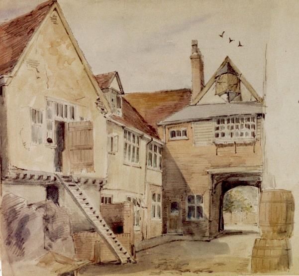
With the construction of the Dock a fairly wide area of river was left between the upper dam and
the cast-iron Stoke Bridge that had been erected by William Cubitt and Ransomes after its
predecessor had been washed away by a flood in 1818. This area became known as St Peter’s
Dock, the quay on the north side being known as St Peter’s Quay; at that time Stoke tidemill
still stood facing downriver on the northern side of the bridge, as may be seen in this late 19th
Century photograph.

In 1925, St Peter’s Quay was
widened by some 20ft at the
Stoke Bridge end and by
some 30ft. at the Dock end in
order to accommodate a third
railway line. This widening
accounts for the somewhat
changed appearance of the
area     in    all   pre-1925
photographs showing barges
in St Peter’s Dock. The last
barge to moor at this quay
was S.B. Victor in October
2009, to celebrate the
completion     of   the Mill
development.

St Peter’s Quay had almost certainly existed before the coming of the Dock, and for some years
the name was also used for the most westerly quay within the Dock, in later days sometimes
called Cranfield’s Quay. On the other side of the river beside the maltings that had been
converted into a temporary barracks at the time of the Napoleonic Wars, immediately below the
bridge, was Stoke Bridge Wharf.

Next to St Peter’s Quay, in front of Pauls’ Maltings, was Albion Wharf, now given the
meaningless name of Regatta Quay by a developer. It is tempting to suggest that this was
named from an Albion public house, but no such dockside pub has been traced. The area in
front of the New Custom House, opened in 1845, (and now rather inappropriately referred to as
the Old Custom House, especially as it still houses the offices of the current Port Authority)
retained the name of Common Quay that it had borne for some six hundred years.

White’s maps of 1849 and 1867 misleadingly give the name Common Quay to the whole area
from the Custom House to the corner where now is Coprolite Street, and plans issued by the
Ipswich Dock Commission in the mid-20th Century name the entire length from the Home
Warehouse to Coprolite Street as Neptune Quay, clearly named after the Old Neptune pub in
Fore Street. However, the western part of this was once known as Wherry Quay, from the sailing
wherries that carried on a daily service for passengers and light goods between Ipswich and
Harwich. In spite of the ‘evidence’ supplied by Fred Russel, who depicted a Norfolk wherry lying
at this quay, the Orwell wherries were very different from the Broadland variety.

Coprolite Street, a new highway of about 1860, was named after the phosphatic nodules (of
dinosaur dung) that were the raw material of the artificial fertiliser industry. From there onwards
the quay fronting Orwell Works was Ransomes’ Wharf, seen below in the late 19th Century with
three barges alongside the foundry; but with the departure of Ransomes, Sims & Jefferies to
another site about 1960 it was renamed Orwell Quay.

The name had originally been used for the quay along the east side of the New Cut. Ransomes’
Wharf extended to Gasworks Quay, where its two hydraulic cranes used to unload the colliers
that brought fuel for the retorts. When the dock was first opened there was a deep inlet with the
original gasworks of 1822 at its head; the Gas Dock, as it was known, was eventually filled in to
provide space for the extension of the gasworks.

                                                                                           Page 4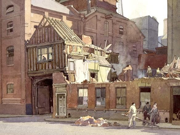
In this photograph, taken by Harry Walters in 1897, the former Steam Packet Tap Inn can be
seen behind the quayside barge at the junction of Neptune Quay and Coprolite Street, now the
site of the University of Suffolk main building.

Beyond Patteson Road was Eagle Wharf, which presumably took its name from Pauls’ Eagle
Mill, vessels berthing there lay alongside the timber stages built out into deeper water as there
was no quay heading in this area.

In the 19th Century the length between the gasworks and the lower dam was the Marine
Promenade, which also extended across the dam and alongside the New Cut as far as the
original lock; for the whole distance it was lined with lime trees. The section of the Promenade
on the east side of the Dock disappeared quite early, probably with the construction in 1880-81
of a new entrance lock cut through the lower dam. The Promenade that was so well
remembered by a past generation of Ipswich people ran only from the new lock to the old one.

The section of roadway on the east of the Dock was named Helena Road, after the former brig-
sloop Helena which was loaned by the Navy in 1868 to serve as a floating church and was
moored in this part of the Dock. She remained at Ipswich until 1880, when she was transferred
by the Navy to other duties.

There were originally no quays on the island site between the Dock and the New Cut, much of
which was taken up by a large millpond, as it was called on a Plan of the Proposed Wet Dock
made by Henry Palmer in 1836. It apparently provided a head of water to operate George
Tovell’s roman cement works on the ‘island’. It was later used as a timber pond for the storage
of imported timber and then became a branch dock, being filled in between 1923 and 1925.

In 1882 an iron-framed public warehouse was built to the north of the original entrance lock,
giving its name to Public Warehouse Quay, as seen in the photograph below, taken in the late
1880s. Remarkably, it stills stands today.
                                                                                     Page 5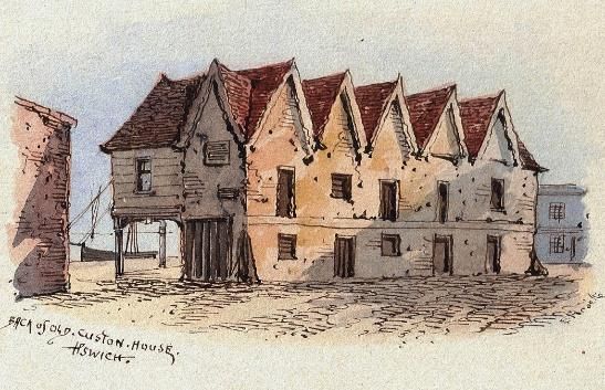
By then the new entrance
lock had been opened, and
in 1904 Timber Quay was
constructed across the
inner end of the old lock, at
the same time that South
West Quay replaced the old
dolphins (mooring post
structures) that had enabled
large ships to berth and
unload their cargoes into
barges and lighters for
transfer to the mills higher
up the dock; the water at the
west end of the dock was
too shallow for large
vessels.

With the filling in of the branch dock in the 1920s End Quay was added to the north of Public
Warehouse Quay and Tovell’s Wharf, named after the one-time owner of the cement mill and
an early dock commissioner, was constructed on the north side of the ‘island’. Three Cranes
Wharf and Flint Wharf lay to the west of Tovell’s Wharf at the upper end of the Dock. The three
small cranes shown on the Ordnance Survey large-scale plan of 1884 provide evidence of the
origin of Three Cranes Wharf, but Flint Wharf remains something of a mystery. The name could
have been derived from the landing of cargoes of flint for Frederick Ransome’s artificial stone
manufactory, later transferred to Greenwich (on the site of the 02 Stadium), but this is mere
speculation.

While the opening of the new lock reduced the number of cargo-carrying vessels in the New
Cut, which soon became the centre for both pleasure and ferry paddle steamers, commercial
shipping still used the Cut until the late 1960s, trading to the Maltings near Stoke Bridge at the
north end, while at the south barges regularly moored on the Black Wall servicing businesses
in the vicinity of Ransomes and Rapier. The latter can be seen in this photo looking west across
the new lock.

                                                                                          Page 6
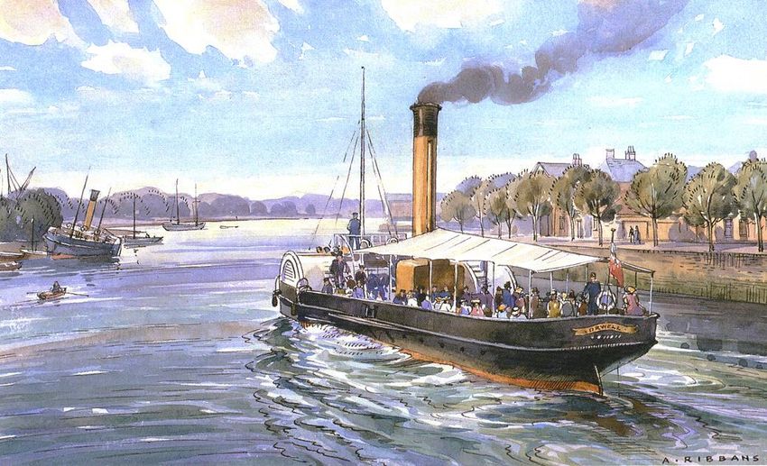
The tree-lined Promenades on both sides of the Cut provided splendid complementary shore-
based recreational areas to the paddle steamers, the first of which, named ORWELL No.1, plied
from New Cut East whose wharf was then known as Orwell Quay. The Griffin ferry linked this
Quay to the wharf of the same name on New Cut West. In this lovely watercolour, by Ipswich
artist Albert Ribbans, a later steamer also named ORWELL, leaves the Cut.

The map extract reproduced below is believed to date from the late 1970s, and was produced
for port operational purposes by the former Ipswich Dock Commission. These and other quay
names mentioned in this article have been added to the following OS map extract from 1884,
and it is suggested that these should be the historic quay names which are recognised and
retained in preference to any others, where relevant.

The Ipswich Maritime Trust welcomes any information from those with more detailed
knowledge of past Ipswich dockside industries who can provide further information on the
origin of some of the quay names

                                                                                    Page 7
COMMON QUAY WHERRY QUAY
NEPTUNE QUAY
ST. PETER’S WHARF ALBION QUAY
STOKE BRIDGE FLINT WHARF
WHARF 3 CRANES WHARF
TOVELL’S WHARF
END QUAY
RANSOMES
QUAY
ORWELL QUAY
PUBLIC
WAREHOUSE
QUAY
TIMBER QUAY
GASWORKS
QUAY
SOUTH WEST
QUAY
GRIFFIN WHARF
EAGLE
WHARF
BLACK WALL
Quay and Wharf names recognised by the Ipswich Dock Commission
during the early years of the 20th Century superimposed on the OS map of
1884 with the later (and current) island site quays shown with a blue line.
Page 8References
Ipswich Through the Ages, Lilian J. Redstone, 1948
A Victorian Vision – The building of Ipswich Wet Dock, Robert Malster and Bob Jones, 1992
Ships and Shipyards of Ipswich 1700-1970, A contribution to the Maritime history of an
Ancient East Coast Port, Hugh Moffat, 2002
The Port of Ipswich – Its Shipping and Trades, Richard W. Smith and Jill Freestone, 2011
Illustrations
IMT Image archive
David Kindred
Ipswich Museums Collection
Ipswich School Archive
Maps
Former Ipswich Dock Commission
Suffolk County Council
In compiling this paper, the first Occasional Paper to be published by IMT, I am grateful for
the help of Bob Malster, Dr John Blatchly, Colchester and Ipswich Museum Service,
Suffolk Record Office, and my colleagues at the Trust.
Stuart Grimwade, September 2011
Ipswich Maritime Trust
Registered Charity No. 286603
The Trust began life in 1982 at a time when the Wet Dock was in serious decline with very few
vessels and many redundant historic buildings. Its aim was to find ways of bringing life back to
the Wet Dock, and its success in this endeavour was largely achieved when its ‘Sail Ipswich’
event in 1997 drew over 35,000 people to the Waterfront over a single week-end. Today, the
principal aim of the Trust is to bring to everyone’s attention the astonishing maritime history of
the Orwell and its Port, reaching back to before the 7th Century, enabling Ipswich to claim to be
the oldest English town. We undertake a wide range of activities which includes holding a series
of winter and spring talks on a maritime related theme, and running the Window Museum on
Albion Wharf for which we are always keen to collect and display maritime artefacts.
More details on the Trust can be found at the IMT website www.ipswichmaritimetrust.org.uk, or
by contacting Des Pawson on 01473 690090.
This revised edition published June 2020 by
Ipswich Maritime Trust, regd. office, 501 Wherstead Road, Ipswich, IP2 8LL
© Text, the author, images from the IMT Image Archive.
Page 9Appendix 1. As mentioned in the introduction to this revised Paper, the intervening years and changing face of the Waterfront have enabled Trust members to research the issue in more depth, using sources such as White’s Directory of 1844, and a contemporary of Richard White, Mr. R. Wodderspoon, whose ‘New Guide to Ipswich’ published in 1842 was not only the first published guide of its kind of the town but, more interestingly, provides a detailed description of the then brand-new Wet Dock. This, in turn, provided much useful information for the creation of the Trust’s Window Museum display No.20 on the building of the Wet Dock. These and other sources such as the local newspapers of the Victorian era give us tantalising glimpses of long-lost property and quay names around the Waterfront both before and after construction of the new Wet Dock. These were times before formally recognised addresses became necessary through the establishment of the Post Office. It would have been natural for a ship’s captain’s orders to quote the name of traders berths using the same name as their premises. In the case of waterfront inns and taverns, the same principle applied. It is not clear what prompted alternative uses of the word ‘Quay’ and ‘Wharf’. This may simply be changing preferences over time, or may indicate changes brought by the coming of official postal addresses, or both. The same applies to the changing spelling over time of the names of surrounding streets, such as ‘Key’ Street and ‘Quay’ Street, ‘Duck’ Street and ‘Duke’ Street. It seems likely that after construction of the Wet Dock, and the creation of a continuous newly built quay both within and outside the new dock in the New Cut, many businesses relocated to newly built premises, leading to a reordering of former quay names and their gradual amalgamation into one new agreed title. To the Trust’s knowledge this is the first attempt to bring the following evidence together. It is therefore incomplete, and may well contain unknown errors, but is presented here as fully as possible. As more evidence is discovered, this can be updated. The following is a selection of other Quays & Wharf names that are mentioned in various publications. I am grateful to Andy Parker and Des Pawson for researching and compiling this list :- Albion Wharf. 5 & 8 Dorling’s Alma Wharf. 10 Bigod’s Quay and Palace12 Bridge Wharf, Dock Street, 1 Carpenters Quay 11 Crown & Sceptre Wharf (named after Crown & Sceptre Inn Quay street). 5 E. Curtis Wharf (Etheridge Curtis). 6 & 7 Dockside. 5 Griffin Inn at New Bank (Stoke) goes on to be Griffin Wharf. 5 Mr James Hare’s Quay, St Clements. 3 Ipswich Navigation Company’s Wharf, 5 Mr William Mays Wharf, St Peters. 4 & 5 Packard’s Quay 14 Ridley’s Quay the address given for the Pilot Inn, likely to relate to H. G. & W. Ridley, Fore Street. 5 Salt Office Quay, near the Green Man Inn. 2 Seekamps Wharf. 8 Smarts Wharf. 5 Stoke Bridge Wharf 13 George Tovell, of Lock Road, gave rise to Tovell’s Wharf named after his business.5 Union Jack, public house, New Quay. 5 Wherry Quay named after the Wherry Inn. 5
1
  The Suffolk Chronicle 01/08/1868
2
  Ipswich Journal 11/07/1778
3
  Ipswich Journal 09/12/1786
4
  Suffolk Chronicle 28/05/1842
5
  Whites Suffolk Directory 1844
6
  Robert Malster & Robert Jones, A Victorian Vision, page 54
7
  Richard Smith, The Port of Ipswich, page 120
8
  Hugh Moffat, Ships and Shipyards of Ipswich, page 46
9
  Hugh Moffat Ships and Shipyards of Ipswich page 39 to 41
10
   A Photograph & Advertisements in newspapers from 1858,1861,1862
11
   Robson’s Ipswich Classification Sailmakers 1839
12
   Bob Malster and others relating to Hugh Bigod’s Ipswich residence in the Middle Ages.
13
   IDC map c.1960 and earlier sources.
14
   Henry Palmer’s quay design cross section dated 1837

It is not possible to identify the exact locations of many of these lost quay names, although some
are possible where photographic evidence exists, such as in the case of Dorling’s Alma Wharf
on New Cut East, in this very early image from around 1860. Soon after the photograph was
taken, the business relocated to Harwich, where the ‘new’ Alma Inn still trades.

These images, two of the earliest photographs in the Trust’s Archive taken in the 1840s soon
after construction of the Wet Dock, show vessels lying on Bridge Wharf (left), and Albion Quay
(right, and possibly then known as New Quay as listed above by the Union Jack public house)
Appendix 2.

    Installation of Historic Quay and Wharf Names by IBC

    The Submission made jointly to Ipswich Borough Council by Ipswich
    Maritime Trust (IMT) and the Ipswich Society.

1. In 2011 IMT published an Occasional Paper proposing the reinstallation of historic quay
   and wharf names commonly in use during the commercial life of the Wet Dock,
   recommending that emphasis be placed on those quay and wharf names recognised
   by the Ipswich Dock Commission during the first half of the 20 th century.

2. New research carried out subsequently by IMT reveals further evidence of the past
   practice of quays being named after the owner or tenant of dockside premises who held
   rights to use the quays for the purposes of loading and unloading cargoes across them.
   This led to frequent changes of name until such time as the establishment of the formal
   postal address system. IMT current research of this is now set out in updated
   Occasional Paper No.1. available on www.ipswichmaritimetrust.org.uk.

3. On the basis of evidence set out in para. 1. above, IBC has now proposed the
   reinstallation of those names still recognised by the Post Office and for which they can
   therefore reinstall street plates.

4. IMT therefore now welcomes the placing of the following plates using the new blue plate
   and crest motif for:

•   New Cut East
•   St. Peter’s Wharf
•   Albion Quay
•   Wherry Quay
•   Neptune Quay
•   Patteson Road
•   Helena Road
•   Ship Launch Road

5. With regard to most of IBC’s proposed locations for these plates, there can be no doubt
   as to the obvious locations.

6. However, in respect of the extent of St. Peter’s Wharf, Albion Quay, Wherry Quay and
   Neptune Quay, O.S. Map and other records reveal different start and finish locations
   depending on the period selected. Consistent throughout almost 1000 years however
   is the location and identification of Common Quay, although it is understood that this
   was never a location named by the Post Office. This is surprising, and IBC is urged to
   review the matter.

7. Of the quays listed in para 4. above St. Peter’s Wharf appears the earliest name to be
   established and retained. Its western extent has remained at Stoke Bridge, but its
   eastern extent has reached as far as Common Quay. The renaming of part of it as
Albion Quay came later in the 19th Century, probably taken from the then newly
constructed Albion Mills. There remains doubt as to the historic western limit of Albion
Quay, but the location selected by IBC (Foundry Lane, with the plate on the DanceEast
building) appears both logical and appropriate given the extent of redevelopment along
its now continuous frontage. A case could be made for its termination at the
passageway occupied by the IMT Window Museum, but again this is a new feature
offering no historic logic for its selection as marking the boundary of St. Peter’s Wharf
and Albion Quay, whereas an eastern limit of St. Peter’s Wharf coincident with the
extent of the tidal St. Peter’s dock gives a much clearer logic.
8. Turning to Wherry Quay and Neptune Quay, both names became well established and
in common use after construction of the Wet Dock, and the creation of Coprolite St,
although Wherry Quay appears to have been ‘absorbed’ into Neptune Quay by the
1960s. Coprolite St. appears to have been regarded as the eastward limit of Neptune
Quay ever since its construction. From this point south the quay then became known
as Ransomes Quay for the whole length of the former Ransomes Sims and Jeffries
factory premises until its extension out into the dock led to it being given the name
Orwell Quay, by which it is commercially known today. The absence of this quay from
the naming scheme is therefore regretted, as is Eagle Wharf still in commercial use
today by Anglo-Norden Ltd.
9. Debate therefore centres of the evidence for coincident eastern limit of Wherry Quay
with the western limit of Neptune Quay, while recognising that Wherry Lane itself has
been a fixed location since medieval days. Historically there appears evidence that the
former Salthouse (now Salthouse Hotel) marks the western limit of Neptune Quay, while
Isaac Lord’s (now Isaacs) premises marked the eastern limit of Wherry Quay. This
boundary is recognised today by postal code.
10. Ideally therefore this should be reflected in separate plates on both premises, rather
than the proposed single location on the wall of the Salthouse Hotel car park. If a plate
marking the eastern limit of Wherry Quay on Isaac’s is not practicable for listed building
reasons, there may be merit in not identifying it at all, rather than positioning both plates
in one (arguably incorrect) position.
11. The remaining issue therefore is to identify a logical point for the western limit of Wherry
Quay. There is historical evidence that before the construction of the Wet Dock there
was no quay in front of properties lying west of Wherry Lane, with medieval properties
abutting the water’s edge. Construction of the new quay, together with the buildings
now occupied by the ‘Bistro on the Quay’ suggest that this area probably then became
part of Wherry Quay, having hitherto been part of Common Quay. IMT therefore
supports IBC’s proposal to define the western end of Wherry Quay as being coincident
with the limits of the highway in front of the Custom House, thereby requiring a name
plate on the former ‘Home’ warehouse.
12. In summary the Ipswich Maritime Trust and the Ipswich Society jointly:
• support the current proposed new quay and wharf name plate locations,• regret the fact that neither Orwell Quay (formerly Ransomes Quay) nor Eagle Wharf
are not to be officially recognised, particularly bearing in mind the number of visitors
to the town who are directed to Orwell Quay in publicity, and therefore request that
means of informally describing the continued commercial roles of these two quays
be further explored, either on relevant buildings or possibly as part of future street
furniture on the quay,
• request that consideration be given to marking the existence of Common Quay with
a suitable name plate on the Custom House, in view of this quay’s important function
in the historic development of the town from medieval times up to and including the
present day.
SG. 21.08.2020You can also read