Risk assessment of Shishper Glacier, Hassanabad Hunza, North Pakistan - NCEG
←
→
Page content transcription
If your browser does not render page correctly, please read the page content below
Journal of Himalayan Earth Sciences Volume 52, No. 1, 2019 pp. 1-11

   Risk assessment of Shishper Glacier, Hassanabad Hunza, North Pakistan
  Attaullah Shah1, Karamat Ali1, Syed Moazzam      Nizami1, Irfan U. Jan2, Iqtidar Hussain1,
                                 Farida Begum , Hawas Khan
                                                1

                     1
    2
                       Karakoram International University, Gilgit, Pakistan
      National Centre of Excellence of Geology, University of Peshawar, Peshawar Pakistan
                    *Corresponding author's email: karamat.ali@kiu.edu.pk
            Submitted: 3/1/2019 Accepted:22/3/2019 Published online:29/3/2019
Abstract

       Over the last five decades the Karakoram Glaciers has revealed irregular behavior and lack of stability.
These anomalies lead surge of glaciers and the formation of glacier lakes, and now risk increasing in the
context of climate change. The hazard associated with glacier lake outburst floods (GLOFs) has become an
increasingly serious threat to the life, property, livelihoods and infrastructure in the Karakoram Mountains of
Pakistan. Shishper Glacier Lake in the Shishper watershed areas of central Hunza in North Pakistan, after its
latest activity has turned to a highly prone GLOF hazard. Shishper Glacier and Glacier Lake in the North
Pakistan can be harmful to the downstream population and have large socioeconomic impacts if an outburst
occurs. This study investigated the spatio-temporal changes in Shishper glacier and its glacial lake, and
associated risk of potential GLOF hazard. Shishper glacier was assessed on the basis of field survey carried
out in December 2018 combine with GIS and remote sensing data for morphometric, land cover change,
physical vulnerability and temporal analysis of Shishper glacier. The Glacier has shown an anomalous
behavior in the month of July 2018, no prominent lake was observed while in the month of November 2018 a
lake with an area of 0.026 km2 was noticed. Similarly, in the month January, 2019 a prominent lake appeared
with an area of 0.057 km2. The physical vulnerability results showed that 80% of the area of Hassanabad
village is highly exposed to GLOFs hazard, whereas low lying areas along the Hunza River are also
susceptible to inundation. The results show that there is immediate danger of catastrophic outburst through
downward movement of the glacier. The study recommends the glacier has an anomalous behavior, it is
necessary to monitor the glacier and Glacier Lake continuously, and minimize the adverse effects of potential
GLOFs risk. We also recommend strong understanding the phenomenon of glaciers therefore, glacier lakes
are very important in north Pakistan with respect to GLOF disaster management.

Keywords: Glacier lake outburst, risk assessment, Shishper glacier, Hazard potential.

1. Introduction                                            raised by 0.85°C in the last three decades. This
                                                           has major implication on rapid melting of
      The world's highest mountain areas are               glaciers and formation of new glacier lakes in
facing many environmental challenges such as               mountainous regions of the world (Yao et al.,
rapid population growth, environmental                     2012; Ashraf, Naz and Iqbal, 2015). The Hindu
degradation, Climate Change (CC), and glacial              Kush-Karakoram-Himalaya (HKH) region and
melting, resulting Glacial Lake Outburst Flood             its biggest glaciation focus in low and middle
(GLOFs) (Cui et al., 2010). The GLOFs event                latitude regions in the world has also been
happens when ice is unable to hold the                     affected by the Climate Change associated with
restraining end moraine wall of loss material              rising temperatures (Dongtao et al., 2004).
from the glacier, often underlain by debris, and           GLOFs have appeared as a serious threat in the
as a result the sudden releases of water from              mountainous region of HKH in last two
impounded lake outburst floods. It can cause               decades due to increase in population growth,
loss of life, injury, serious damage to property           climate change, economic development and
and livelihoods to the downstream                          many other anthropogenic activities in these
communities (Khanal, Hun and Mool, 2005;                   areas which were inhabited and were not
Gurrung et al., 2017).                                     advanced previously (Khanal et al., 2015; Nie
                                                           et al., 2017). Global warming has intensified
     According to the Fifth Assessment Report              the risk of GLOFs, and in future, such events
of IPCC (2013), the Earth temperature has                  can increase. GLOFs risk can be reduced
                                                      01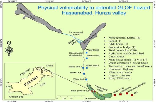
through a comprehensive risk assessment and             area. Hassanabad ravine (naalah) originates
appropriate mitigation measures. To this end,           from Shishper and Mochowar glaciers, and
comprehensive evaluation of GLOFs hazard,               runs toward the south, joining with the adjacent
vulnerability and risk is imperative. However,          Hunza River. The total watershed area is
efforts have been made to establish procedures,         approximately 359 km2 (Fig.1). The study site
approaches and guideline for such an                    (36° 15´ – 36° 30´N latitude, 74° 28´ – 74° 39´ E
assessment (Carey, Huggel, Bury, Portocarrero,          longitude) comprises the Hassanabad
& Haeberli, 2012; Schneider, Huggel,                    watershed in district Hunza, north Pakistan.
Cochachin, Guille´n, & Garcı´a, 2014; Worni,            The Shishper Basin is extremely prone to
Huggel, & Stoffel, 2013). Alford (2007),                Glacier lake outburst flood because of the swift
mentioned that socioeconomic vulnerability              advancement of Shishper Glacier and blockage
assessment is a crucial part of a comprehensive         of Hassanabad naalah. An integrated approach
risk assessment for disaster risk reduction in          was adapted to assess the potential risk of
mountainous areas together with the hazard and          Shishper GLOF by integrating Geo-
exposure assessment. But procedure and                  morphometric assessment, land cover change
methods are scanty for vulnerability and risk           and temporal analysis, physical vulnerability
evaluation of potential GLOF events in                  assessment and community perceptions on
downstream areas.                                       Shishper glacier. The study area has an essential
                                                        role in hydro-power generation for Hunza
      Rapid melting and expansion of glaciers is        Valley (Hassanabad power complex: 1200 KW
a serious threat in Karakoram and Himalayan             Norwegian unit, 700 KW Chinese unit and
region. The Shishper/Hassanabad glacier,                2000 KW Diesel generated power station). The
south-facing exposed glacier located south of           elevation ranges within the watershed from
the Batura glacier has stretched significantly          2000 to 7,700 m.a.s.l. While the mean annual
toward the south-west direction from northeast.         precipitation is 125mm and average
Over the last few years a slight movement was           temperature is 11 °C.
observed in Shishper glacier whereas, in the
month of July 2018 a rapid growth was                   3. Material and methods
observed. Resultantly, flow of Hassanabad
stream has blocked and a glacier lake formed,                An integrated approach was adapted to
1km south-west of Aliabad city, district Hunza,         assess the potential risk of Shishper GLOF by
north Pakistan. The glacier lake is highly              integrating Geo-morphometric assessment,
vulnerable to lives and properties of                   land cover change and temporal analysis, in
Hassanabad village and low lying areas along            addition to physical vulnerability assessment
Hunza River. Whereas high cost infrastructures          and community perceptions on Shishper
are highly exposed to running hydro-                    glacier. The data required are obtained from the
powerhouse, under construction powerhouse               following sources. Advance Spaceborne
and a bridge of the Karakoram Highway (Pamir            Thermal Emission and Reflection (ASTER)
times, August 2018; Baig, Dad and Salim                 Digital Elevation Model (DEM, 30m ground
2018). The aim of this paper was to assess              resolution) was downloaded from the National
potential risk of Shishper Glacier and Glacier          Aeronautic and Space Administration (NASA),
Lake and suggest some mitigation measures.              open Geo-database. Basin modeling technique
The specific objectives of the paper is i)              was applied in a GIS environment to demarcate
morphometric analysis of the Shishper                   Shishper Basin and extracted drainage network
watershed, ii) Assessing land cover change and          by using ASTER DEM as input spatial data.
glacier movement between 2015-2018 and iii)             Eight Geo-morphometric factors were added
physical vulnerability assessment.                      by applying established Hortonian and Strahler
                                                        Geo-morphological laws. Remote sensing
2. Study area                                           techniques can be used to assess the land cover
                                                        classes and land cover change. Satellite images
    Hassanabad is a small village adjacent to           have served a great deal in the land use, land
Aliabad city, Hunza, Northern Pakistan.                 cover classification of different landscape
Karakorum Highway crawls through the study              components on a larger scale (Ozesmi and
                                                   02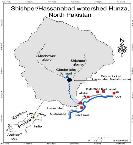
Bauer, 2002). Satellite data for 3 years                      An evaluation of physical vulnerability
consisted of multi spectral data acquired by             indicates the documentation of the exposed
Sentinel-2 satellite in the month of September           essentials at risk and is usually described as the
provide by Sentinel-ESA. ERDAS imagine                   negative impact of hazardous events on
2014 was used, preprocessed for geo-                     susceptible elements. (Karagiogos et al., 2016).
referencing, mosaicking, and sub-setting of              In this study, multiple approach was used to
Area of Interest (AOA) from the image.                   determine physical vulnerability such field
Shishper watershed was classified into four              observations, local community participation in
main classes (snow and clean glacier, debris             the identification and mapping of susceptible
glacier, vegetation and barren land) on the bases        elements combines with GIS and remote
of specific Digital Number (DN) of various               sensing techniques.
landscape elements. The maximum likelihood
algorithm was utilized for supervised
classification of the image.

      Fig. 1. Location map of study area.

                                                    03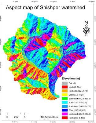
4. Result and discussion Drainage texture indicates channel spacing in a
fluvial dissected terrain which depends on a
4.1. Morphometric analysis number of natural factors such as lithology, soil
type, climate and vegetation. Smith (1950)
The results of morphometric analysis of classified drainage texture as follows: 8
2 and in Figure 2. The total area of the very fine. The drainage texture of the Shishper
watershed is 359 km2 while the perimeter is watershed is 4.05 which indicate coarse
88km. The watershed's elevation ranges from drainage texture. It seems that the massive and
2000 m.a.s.l in the south to about 7700 m.a.s.l in resistant rocks and high relief have produced
the north. Overall, 61% of the area fall between very coarse to coarse drainage texture basin.
4000m to 7,700m altitude, whereas glaciers According to Strahler (1964) total number of
normally accumulate more snow in the winter. streams and stream types in a watershed is
Overall, north, northeast and east aspect cover called stream ordering. Shishper watershed is
29% of the basin area, 46% of the area covered designated as a fourth-order basin.
by south, southeast and southwest aspect
whereas 25% area covered by west, northwest 4.2. Land cover change and observation of
and north aspect. The watershed covered 28% glacier movement
of the area by very steep slope class (48°-78°),
while 45% of the area covered by steep slope The distribution and change in land cover
(28°- 47°) whereas 20% of the area covered by during the three years is given in Table 3. The
low and moderate slope (12°- 27°). According land cover category of snow and clean glacier
to Horton (1945) drainage density is the total increased from 97 km2 to 123km2 from 2015 to
stream length per unit area of a basin. Poorly 2018. Similarly, debris glacier also increased
drained basin has drainage density 2.74, while from 64 km2 to 84 km2 from 2015 to 2018. An
well drained has 0.73. The drainage density of increase was observed in snow and clean
the Shishper watershed is 0.33 km/km2. Steam glacier from 27% to 34% and debris glacier
frequency shows the texture of the drainage from 18% to 21% during these three year
network, which depends on lithological period. Whereas the slight decline was
conditions of a basin. However, stream observed in the case of vegetation, a total of 44
frequency characterized by steeper surface, km2 (13%) vegetation in the year 2015 to 38
impermeable subsurface material, high surface km2 (11%) by the end of 2018 (Figure 3).
runoff, sparse vegetation and high relief setting.
The stream frequency of Shishper watershed is Glaciers are one of the major water
0.14 per km2. resource in Pakistan. Glaciers in the Karkoram
Mountains are surging and depict anomalous
The circularity ratio of a basin indicates behavior (Hewitt, 2005; Minora et al 2013;
the rate of infiltration and reach time for the Gardelle, 2012). In Shishper watershed two
excess water in the outlet of the basin, which main glaciers are exist namely, Shishper and
depends upon lithology, geological conditions Mochowar glacier, and the watershed has two
and vegetation cover. The circularity ratio of tongues glacier. The Shishper and Muchowar
the Shishper watershed is 0.58, indicating a less glacier was assessed by remotely sensed
elongated basin, which also revealed a strong Sentinel-2 ESA high resolution images
structural control on drainage development. acquired.
The watershed indicates a uniform rate of
infiltration as well as it can take long time to Our study indicates the anomalous
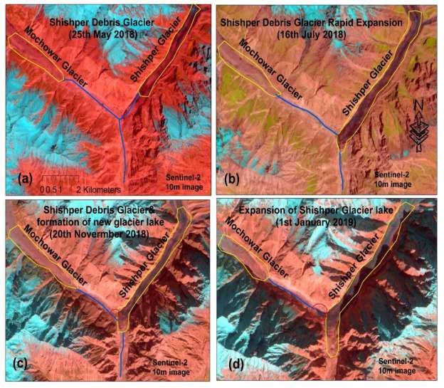
reach excess water to the basin outlet. behavior of Shishper glacier. Spatial and
Elongation ratio indicates the shape of a temporal changes in snow, clean and debris
drainage basin, and the ratio usually runs from glacier shown in Figure 4. In the month of May
0.6 to 1.0 in a broader range of climatic and 2018, the stable situation was found in Shishper
geological setting. The elongation ratio for the and Muchowar glacier. Moreover, in the month
watershed is 0.8 which indicate oval shape of July 2018 a dramatic movement was
basin with high relief and substantial slope. observed in Shishper glacier, and it collided
04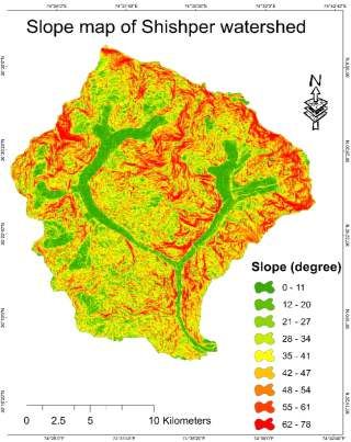
with Muchowar Mountain and completely                    (i-e from November 2018 to January 2019) a
 blocked water flow of Hassanabad Naalah. In              prominent lake appeared with an area of 0.057
 the month of July 2018 no prominent lake was             km2. Figure 5b and 5d shows terminus of
 observed in the image while in the month of              Shishper glacier and its newly formed Glacier
 November 2018, a lake with an area of 0.026              Lake.
 km2 was noticed. Similarly, within two months

Fig. 2. Morphometric characteristic of Shishper watershed.

                                                     05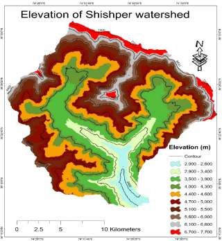
Fig. 3. Shishper watershed land cover change between 2015 and 2018.

                                                  06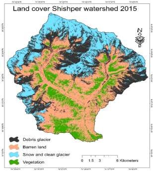
Fig. 4. Temporal analysis of Shishper glacier and Glacier Lake.

                                                    07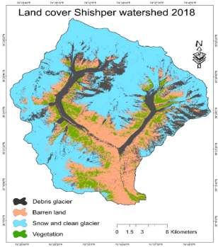
4.3. Physical vulnerability                              processes and the magnitude of such an event.
                                                         The finding shows Hassanabad village is highly
      Physical vulnerability refers to the               susceptible for Shishper GLOF hazard. Figure
exposure of a place towards a possible event             6 which shows the risk elements and areas,
(i.e. Lake Outburst). According to the IPCC              helps to infer that 100% area of the village is
(2012) the presence of human and natural                 located in the area of GLOF hazard as well as
environment, tangible and intangible assets,             low lying areas in the downstream are at high
human activities and services, infrastructures in        risk of Shishper GLOF hazard. The land use of
an area can be affected by the hazard. The               Hassanabad village is dominated by residential
physical vulnerability assessment has focused            buildings, farm and orchard land and power
on the both sides of Hassanabad naalah                   complex of power generation plants (figure 3
(ravine). The exposure depends on physical               and 6).

Fig. 5. (a) Shows Shishper and Mochowar glacier (b) Shishper glacier debris.

 Fig. 6. Physical vulnerability map of Hassanabad village.
                                                    08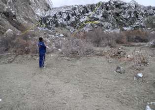
5. Conclusion                                            Shishper Glacier and Glacier Lake need
                                                         immediate attention for GLOF risk reduction.
      The Shishper basin is a sub-basin of               The glacier and glacier lake risk reduction
Hunza basin in Pakistan, which covers very a             strategies should focus on (1) continuous
large glacier system. In this study, we followed         monitoring of the glacier movement and
a multi-method for risk assessment of Shishper           Glacier Lake is required to avoid exposure of
glacier and Glacier Lake using Sentinel                  life, property and infrastructure in flood-prone
imagery, an assessment of hazard potential of            areas; (2) establishing early-warning system in
identifying lake based on high-resolution                the source area, more lead time is very
imagery, risk assessment of surging glacier              important in early-warning for those living in
based on field evidence and remote sensing               low laying areas to respond to the GLOF event;
data. It is inferred that the Hassanabad Naalah          (3) reducing the current GLOF hazard through
(Ravine) is mainly dominated by first order              community awareness and preparedness; (4)
streams, the watershed show dendritic drainage           strong cooperation among the institutions is
pattern, which thus show homogeneous                     needed for research and sharing information on
lithology. The majority of the streams orders            the issues related glacier hazard to reduce
are fall in first-order and then second order            GLOF risk; (5) national and international
stream case. The watershed is designated as a            community must mobilize the resources for
fourth-order basin. The elevation ranges from            addressing GLOF issues and climate change
2000 to 7,700m m a.s.l. The drainage density             induced disasters for the holistic disaster risk
value of the Shishper basin has a value of 0.33          reduction.
k m/k m2 th at r ev ealin g s u b s u r f ace is
impermeable, a characteristic feature of the             Authors’ Contribution
high density drainage system. The circulation,
elongation and drainage texture values of the                  Attaullah shah proposed the main concept
basin are 0.58, 4.57 and 4.05, respectively. The         and involved in field visits, critical revision of
results show that there is a strong structural           the article and final approval of the version to
control on drainage development. The                     be published. Karamat Ali, involved in data
morphometric parameters indicate that                    collection, GIS based mapping and in write up.
Shishper basin is a high risk basin for flash            Syed Moazzam Nizami review and proof read of
floods. The total cover area of Shishper                 the manuscript. Irfan Ullah Jan provided
watershed is approximately 359 km2. The                  critical feedback and helped shape the research
results reveal a significant increase in snow            and contributed the final version of the
cover, clean and debris glacier between 2015-            manuscript. Iqtidar Hussain involved in data
2018; increasing from 161km2 to 197 km2. The             collection and assistance in preparation of
land cover change analysis demonstrates that             figures. Farida begum involved in proof read of
the dramatic increase in snow and glacier cover          the manuscript and provided assistance in
can enhance glacier related disaster risks. The          review.
analysis of remote sensing data reveals that the
Shishper glacier surged in the month of July             References
2018 and a glacier lake has formed. The satellite        Ashraf, A., Naz, R., Iqbal, M. B., 2017.
observations show a significant downward                      Altitudinal dynamics of glacial lakes
movement of the Shishper glacier between July                 under changing climate in the Hindu
2018 to January 2019 and lake size is increasing              Kush, Karakoram, and Himalaya ranges.
from 0.026 km2 to 0.057 km2. Glacier                          Geomorphology, 283, 72-79.
movement and Glacier Lake are expected to                Baig, S. U., Dad. A., Salim. A., 2018. Impact of
increase in the upcoming months due to                        Sudden Advancing of Shishper Glacier -
increased summer air temperature over the                     A Case Study of Interaction between
basin. The physical vulnerability results                     Hydrology and Natural Environment in
indicate that more than 80% of residential                    the Karakoram Mountains.
buildings including property, agricultural land,              Environmental Analysis and ecological
hydroelectric power plant infrastructure and                  studies, ISSN 2578-0336.
KKH Bridge are highly vulnerable to GLOF                 Baig, S. U., Khan, H., Din, A., 2018.
therefore expose to high risk.                                Spatio‐temporal analysis of glacial ice
                                                    09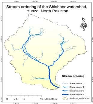
area distribution of Hunza River Basin,            Horton, R. E., 1945. Erosional development of
      Karakoram region of Pakistan.                           streams and their drainage basins;
      Hydrological Processes, 32(10), 1491-                   hydrophysical approach to quantitative
      1501.                                                   morphology. Geological society of
Bhambri, R., Hewitt, K., Kawishwar, P., Pratap,               America bulletin, 56(3), 275-370.
      B., 2017. Surge-type and surge-modified            Huggel, C., Giráldez, C., Haeberli, W.,
      glaciers in the Karakoram. Scientific                   Schneider, D., Frey, H., Schaub, Y.,
      Reports, 7(1), 15391.                                   Rohrer, M., 2013. Climatic extreme
Carey, M., Huggel, C., Bury, J., Portocarrero,                events combine with impacts of gradual
      C., Haeberli, W., 2012. An integrated                   climate change: recent evidence from the
      socio-environmental framework for                       Andes and the Alps. In EGU General
      glacier hazard management and climate                   Assembly Conference Abstracts, Vol. 15.
      change adaptation: lessons from Lake               Karagiorgos, K., Thaler, T., Heiser, M., Hübl,
      513, Cordillera Blanca, Peru. Climatic                  J., Fuchs, S., 2016. Integrated flash flood
      Change, 112(3-4), 733-767.                              vulnerability assessment: insights from
Cruz, R. V., Harasawa, H., Lal, M., Wu, S.,                   East Attica, Greece. Journal of
      Anokhin, Y., Punsalmaa, B., Huu Ninh,                   Hydrology, 541, 553-562.
      N., 2007. Impacts, Adaptation and                  Khanal, N. R., Hu, J. M., Mool, P., 2015.
      Vulnerability. Contribution of Working                  Glacial lake outburst flood risk in the
      Group II to the. Fourth Assessment                      Poiqu/Bhote Koshi/Sun Koshi river basin
      Report of the Intergovernmental Panel on                in the Central Himalayas. Mountain
      Climate Change, 469-506.                                Research and Development, 35(4), 351-
Cui, P., Dang, C., Cheng, Z., Scott, K. M., 2010.             364.
      Debris flows resulting from glacial-lake           Khanal, N. R., Hu, J. M., Mool, P., 2015.
      outburst floods in Tibet, China. Physical               Glacial lake outburst flood risk in the
      Geography 31, 508–527.                                  Poiqu/Bhote Koshi/Sun Koshi river basin
Dongtao, M. A., Jianjun, T. U., Peng, C. U. I.,               in the Central Himalayas. Mountain
      Ruren, L. U. 2004. Approach to mountain                 Research and Development, 35(4), 351-
      hazards in Tibet, China. Journal of                     364.
      Mountain Science, 1(2), 143-154.                   Komori, J., Koike, T., Yamanokuchi, T.,
Gardelle, J., Berthier, E., Arnaud, Y., 2012.                 Tshering, P., 2012. Glacial lake outburst
      Slight mass gain of Karakoram glaciers in               events in the Bhutan Himalayas. Global
      the early twenty-first century. Nature                  Environmental Research, 16, 59-70.
      geoscience, 5(5), 322.                             Minora, U., Bocchiola, D., D'Agata, C.,
Gardelle, J., Berthier, E., Arnaud, Y., Kaab, A.,             Maragno, D., Mayer, C., Lambrecht, A.,
      2013. Region-wide glacier mass balances                 Smiraglia, C. 2013. 2001–2010 glacier
      over the Pamir-Karakoram-Himalaya                       changes in the Central Karakoram
      during 1999-2011.The Cryosphere, 7(6),                  National Park: a contribution to evaluate
      1885-1886.                                              the magnitude and rate of the" Karakoram
Geneva, S., 2013. Intergovernmental Panel on                  anomaly". The Cryosphere Discussions,
      Climate Change, 2014. Working Group I                   7(3), 2891-2941.
      Contribution to the IPCC Fifth                     Nie, Y., Sheng, Y., Liu, Q., Liu, L., Liu, S.,
      Assessment Report. Climate Change.                      Zhang, Y., Song, C., 2017. A regional-
Gurung, D. R., Khanal, N. R., Bajracharya, S.                 scale assessment of Himalayan glacial
      R., Tsering, K., Joshi, S., Tshering, P.,               lake changes using satellite observations
      Penjor, T. 2017. Lemthang Tsho glacial                  from 1990 to 2015. Remote Sensing of
      Lake outburst flood (GLOF) in Bhutan:                   Environment, 189, 1-13.
      cause and impact. Geoenvironmental                 Ozesmi, S. L., Bauer, M. E., 2002. Satellite
      Disasters, 4(1), 17.                                    remote sensing of wetlands. Wetlands
Hewitt, K., 2005. The Karakoram anomaly?                      ecology and management, 10(5), 381-
      Glacier expansion and the 'elevation                    402.
      effect,'Karakoram Himalaya. Mountain               Riaz, S., Ali, A., Baig, M. N., 2014. Increasing
      Research and Development, 25(4), 332-                   risk of glacial lake outburst floods as a
      340.                                                    consequence of climate change in the
                                                    10
Himalayan region. Jàmbá: Journal of Wang, W., Yao, T., Yang, W., Joswiak, D., Zhu,
Disaster Risk Studies, 6(1), 1-7. M., 2012. Methods for assessing regional
Rosenzweig, C., Casassa, G., Karoly, D. J., glacial lake variation and hazard in the
Imeson, A., Liu, C., Menzel, A., southeastern Tibetan Plateau: a case study
Tryjanowski, P. 2007. Assessment of from the Boshula mountain range, China.
observed changes and responses in Environmental Earth Sciences, 67(5),
natural and managed systems. 1441-1450.
Strahler, A. N., 1964. Part II. Quantitative Yasmeen, Z., Afzaal, M., 2017. Application of
geomorphology of drainage basins and Remote Sensing for Temporal Mapping of
channel networks. Handbook of Applied Glacier and Glacial Lake. Pakistan
Hydrology: McGraw-Hill, New York, 4- Journal of Meteorology, 13(26).
39.
Times, P., 2018. A Swift Expansion of Shishper
Glacier & Its Implications. August 28.
http://pamirtimes.net/
Times, P., 2018. Potential Implications of the
expanding Shishper Galcier. December
11. http://pamirtimes.net/
11You can also read