SD28 - Halton Borough Council
←
→
Page content transcription
If your browser does not render page correctly, please read the page content below
SD28
 Biodiversity – DALP Topic Paper 2020

1.      Introduction
1.1.     Biodiversity is the range of different species of plants and animals that exist in a
         particular area – the ‘variety of life’. It is a key component to supporting life on the
         planet and plays a vital role in adaptation to our rapidly changing environment. The
         main threats to biodiversity are associated with human activities, for example
         development, which causes damage to or loss of habitat; day-to-day activities such as
         transportation and industry which cause pollution and, ultimately, contribute towards
         climate change; and the killing of plants and animals, whether for food or as associated
         with development or other activities (e.g. war).
1.2.     A number of environmental designations exist at international, national, regional and
         local levels, with the aim inter alia of protecting species and habitats from damage.
         These include Special Areas of Conservation (SAC), Special Protection Areas (SPA),
         Ramsar sites, Sites of Special Scientific Interest (SSSIs) and National and Local Nature
         Reserves (NNRs / LNRs).
2.      Context Review
       Evidence Source                        Key Objectives and messages
 NPPF 2019                  Section 15 relates to ‘Conserving and enhancing the natural
                            environment’. It sets out that the planning system should
                            contribute to and enhance the natural and local environment by
                            protecting valued landscapes; recognising the wider benefits of
                            ecosystem services; minimising impacts on biodiversity, providing
                            net gains where possible and halting the overall decline by
                            establishing ecological networks that are resilient to change. Local
                            planning authorities should set criteria based policies against
                            which proposals for any development on or affecting protected
                            wildlife sites will be judged. (Distinctions should be made between
                            the hierarchy of international, national and locally designated sites
                            so that protection is commensurate with their status). Local Plans
                            should plan positively for the creation, protection, enhancement
                            and management of networks of biodiversity and green
                            infrastructure. Planning policies should plan for biodiversity at a
                            landscape scale and across LPA boundaries. Local ecological
                            networks should be identified and mapped (includes biodiversity
                            sites, wildlife corridors, stepping stones and areas identified by
                            local partnerships for restoration or creation). Policies should
                            promote preservation and restoration of priority habitats and
                            species. In Nature Improvement Areas, LPAs should consider
Evidence Source Key Objectives and messages
specifying the types of development that may be appropriate in
these areas.
UK Post-2010 Succeeds the UK Biodiversity Action Plan. The Framework shows
Biodiversity how the work of the four UK countries joins up with work at a UK
Framework (July level to achieve international biodiversity strategies and
2012) obligations. Vision is that ‘By 2050, biodiversity is valued,
conserved, restored and wisely used, maintaining ecosystem
services, sustaining a healthy planet and delivering benefits
essential for all people’.
Biodiversity 2020: A The ‘mission’ of this strategy is to halt overall biodiversity loss,
strategy for England's support healthy well-functioning ecosystems, and establish
wildlife and coherent ecological networks, with more and better places for
ecosystem services nature for the benefit of wildlife and people.
(2011). Progress
update provided July
2013
UK Biodiversity Indicators summarise complex data into more simple,
Indicators standardised and communicable figures. First published in June
2007 and published annually ever since – most recently December
2019. The indicators show changes in various aspects of
biodiversity, such as the population size of important species, or
the area of land managed for wildlife.
The Status of The reports are based on a survey of 48 of the 53 Local Wildlife Site
England’s Local partnerships across England. The survey found that more than
Wildlife Sites 2014 11% of 6,590 Local Wildlife Sites monitored in the period 2009 –
2013 were lost or damaged. Issues include the effective
identification, management and protection of Local Wildlife Sites
in their area and to combat the causes of neglect, inappropriate
management and development pressures that threaten these
sites.
Green Infrastructure This is a guidance document to be used by stakeholders to
to Combat Climate influence and provide evidence for policy and delivery on this
Change: A Framework crucial and long term agenda.
for Action in Cheshire,
Cumbria, Greater
Manchester,
Lancashire and
Merseyside (2011)
North West Marine The UK is divided into marine planning regions with an associated
Plan plan authority who prepares a marine plan for each area.
A marine plan:
sets out priorities and directions for future development
within the plan areaEvidence Source Key Objectives and messages
informs sustainable use of marine resources
helps marine users understand the best locations for their
activities, including where new developments may be
appropriate.
The MMO will always consider the benefits of economic
investment alongside the need to conserve and protect marine
species and habitats. The views of Local Authorities and the land-
use plans behind them, will continue to inform the development
of Marine Plans.
Liverpool City Region The Liverpool City Region (LCR) Ecological Network is an evidence
Ecological Network base which comprises ecological and biodiversity information on
the City Region’s natural assets. Its purpose is to identify
opportunities to enable better protection and management of
those natural assets and at the same time, describes opportunities
to create new natural assets.
Halton Biodiversity Action Plans for reedbeds and coastal saltmarsh habitation.
Action Plan (2003)
Halton Natural Assets This strategy is both a policy and an action document. It provides
Strategy (2007-12) information on the natural environment of Halton and how actions
will be carried out to protect, manage and enhance this resource.3. Current Baseline
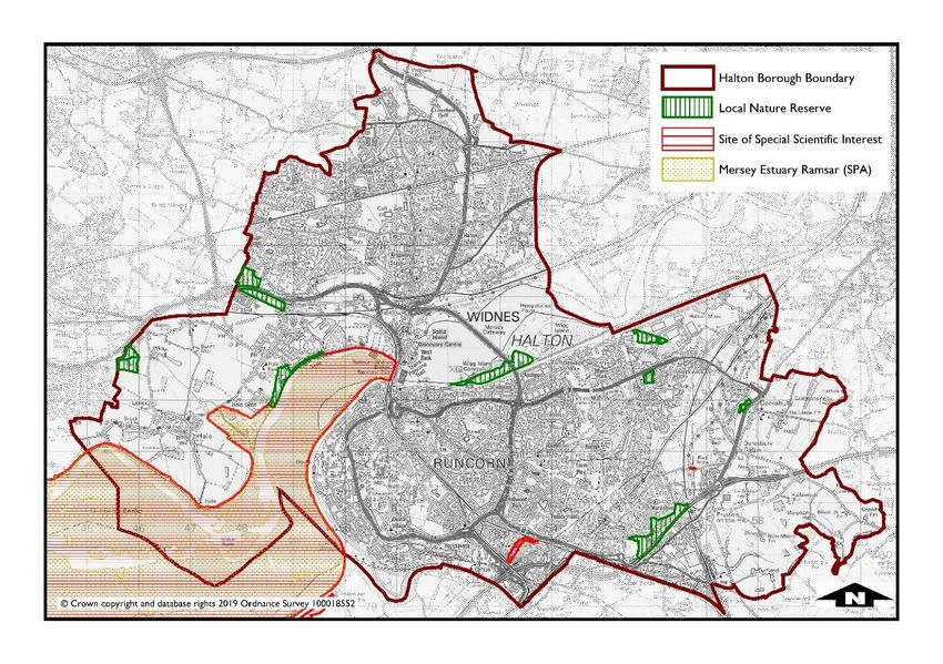
Nature Conservation Site in Halton
Map of site by designation in Halton (Map 1)
Special Protection Areas (SPAs) / Ramsar Sites
3.1. SPAs are areas which have been identified as being of international importance for the
breeding, feeding, wintering or the migration of rare and vulnerable species of birds
found within European Union countries. They are European designated sites,
classified under the ‘Birds Directive 1979’. Within Halton the Mersey Estuary is
designated as a Special Protection Area.
Halton has one Special Protection Area (SPA)
3.2. Ramsar sites are wetlands of international importance, designated under the Ramsar
Convention, which provides for the conservation and good use of wetlands. Wetlands
are defined as areas of marsh, fen, peatland or water, whether natural or artificial,
permanent or temporary, with water that is static or flowing, fresh, brackish or salt,
including areas of marine water the depth of which at low tide does not exceed six
metres. Sites qualify for Ramsar status if they meet a set of criteria, including
supporting 20,000 or more water birds or 1% of the population of one species or
subspecies of water bird.Halton has one Ramsar Site
Mersey Estuary, the qualifying features of the SPA that was designated in 1995
and updated in 2004 contain:
o Black-tailed godwit Non-breeding (Limosa limosa islandica),
o Dunlin Non-breeding (Calidris alpina alpina),
o Golden plover Non-breeding (Pluvialis apricaria)
o Pintail, Non-breeding (Anas acuta),
o Redshank Non-breeding (Tringa totanus),
o Shelduck Non-breeding (Tadorna tadorna),
o Teal Non-breeding (Anas crecca) and
o Non-breeding Waterbird assemblage.
National Nature Reserves
3.3. National Nature Reserves (NNRs) were established to protect some of the country’s
most important habitats, species and geology, and to provide ‘outdoor laboratories’
for research. Natural England manages about two thirds of England’s NNRs. The
remaining reserves are managed by organisations approved by Natural England, for
example, the National Trust, Forestry Commission, RSPB, Wildlife Trusts and local
authorities.
Halton contain no National Nature Reserves.
Sites of Special Scientific Interest
3.4. Sites of Special Scientific Interest (SSSIs) are the country’s best wildlife and geological
sites and need active management to maintain their conservation interest. SSSIs
support plants and animals that find it more difficult to survive in the wider
countryside, and they hold some of our rarest and most threatened wildlife and
geology. In addition, SSSIs perform a wide range of functions, including:
Peat bogs and woodlands lock up carbon, helping to tackle the effects of climate
change
Natural rivers, wetlands and their catchments help to reduce the risk of flooding
in our urban areas and agricultural land
There are three SSSI’s within Halton:
Red Brow Cutting
Flood Brook Cough; and
Mersey Estuary
Local Nature Reserves
3.5. Within Halton there are a number of locally designated nature reserves these include:
Clincton Wood
Daresbury Firs (Keckwick Hill)
Dorchester Park
Hale Road Woodland
Mill Wood and Hopyard Wood Murdishaw Wood and Valley
Oxmoor
Pickerings Pasture; and
Wigg Island
Biodiversity Action Plan Habitats
3.6. Reedbeds occur in Halton as part of the Upper Mersey Estuary, with a history of
wildfowling on the reedbeds. 15 hectares occur in Halton, one main site is (over 2ha)
at Astmoor, to the east of Wigg Island community Park. According to the BAP 2002
there are over 50 species recorded on this site. Site identified for possible small-scale
reedbed creation include Oxmoor Local Nature Reserve, Pickering’s Scrape and
Wharford Farm. Key species on the sites include: breeding snipe, reed warbler and
reed bunting; over wintering teal and raptors.
3.7. Saltmarshes in Halton are found on the Mersey Estuary and alongside the River
Mersey upstream from the Runcorn Silver Jubilee Bridge. 166 ha occur in Halton, with
the main site at Hale Marsh (72ha), Astmoor (51ha) and Widnes Warth (45ha). There
is a history of grazing on all saltmarshes but currently those at Astmoor and Widnes
are ungrazed.
3.8. The Hale, Widnes Warth and Astmoor areas of the Mersey are subject to a cycle of
accretion and erosion due to changes in the river channel.
Ecological Networks
3.9. England has a wide range of different types of statutory and non-statutory designation
for habitat protection. Sites can be segregated into three levels based on their
purpose and level of protection offered:
a) Sites with a primary purpose of nature conservation and which have a high level
of protection due to statutory status or ownership (e.g. Natura 2000 sites, SSSIs
and National Nature Reserves);
b) Sites designated for their high biodiversity value but which do not receive full
statutory protection (e.g. county-level Biological Heritage Sites);
c) Areas designated for landscape, culture, and / or recreation and with wildlife
conservation included in their statutory purpose (e.g. areas of outstanding
natural beauty).
3.10. Site designations alone are insufficient for protecting the species, ecosystems, and
ecosystem processes found in England’s landscapes. To accommodate these natural
assets, the need to plan for the protection and management of ecological networks
has been recognised. Several recent efforts have led to increased focus on ecological
networks.
3.11. Development of the Liverpool City Region Ecological Network, and the accompanying
framework reports, is a local response to government targets for halting biodiversityloss and safeguarding ecosystem goods and services. It will enable local planning
authorities in the Liverpool City Region to address the requirements in the NPPF.
3.12. The development of an ecological network as a conservation strategy is intended to
maintain the function of the ecosystem in order to support the conservation of species
and habitats while also promoting land management strategies that limit the impacts
of human activities on biodiversity.
4. Likely Future Baseline
a) Threats to biodiversity are often beyond local control, as they extend to and
beyond human activity. The effects of climate change and flooding will be a threat
to the Borough’s biodiversity in the future. Travel patterns and pollution are also
a significant threat.
b) International and National designations will continue to receive protection
through European and national legislation, but adequate mitigation or
compensation may not be achieved in the right places if criteria based policies are
not effective.
c) Development may threaten linkages or ‘networks’ between important nature
sites if the correct criteria-based approach which prioritises the protection of
these sites is not achieved through planning policy. As a result, habitats could
become more fragmented
5. DALP Issues
a) The creation of a multi-functional network of green spaces is not aimed at
preserving biodiversity, but the delivery of wider spatial outcomes that
incorporate environmental, social and economic benefits. Whilst the biodiversity
components of any green infrastructure network would retain their intrinsic
value, its differing objectives cannot guarantee benefits for the biodiversity
resource.
b) The potential loss of valuable greenfield sites within the urban areas will further
increase habitat fragmentation and possibly threaten the long term viability of
biodiversity interest on other sites in the immediate vicinity.
c) The effects of climate change on biodiversity, including loss of habitat and habitat
squeeze – a threat which is difficult to quantify and measure. It will be necessary
to gain an understanding of the short, medium and long term changes to
biodiversity and how resilience can be built into the natural environment.
d) There is a growing recognition that biodiversity is not restricted to designated
areas. The contribution made to habitat connectivity by infrastructure such as
street trees and domestic gardens can be significant. Protection and
enhancement of wildlife corridors is an important priority – particularly as a
means of promoting biodiversity in more urban areas of the Borough. We need
to establish a coherent network of green corridors, to improve habitat
connectivity and help facilitate species transfer.6. Data Limitations
a) It is difficult to quantify or qualify all the potential biodiversity in the Borough, and
there will inevitably be important sources such as brownfield land and residential
gardens which are an important component of biodiversity and habitats, housing
many species, that will be omitted from surveys.
b) There is also a lack of local information in relation to flora and fauna.
c) There are complex interrelationships between species and their habitats for day-
to- day survival and for migration, dispersal and genetic exchange in adaptation
to environmental conditions (particularly climate change). Whilst some species
are restricted to protected sites supporting certain habitats, many others require
a patchwork of inter-connecting habitats, the scale and diversity of which
depends on their ecological characteristics and requirements.
d) Many important protected and rare species (e.g. bats, great crested newts and
barn owls) occur outside statutory sites.You can also read