FOREST DEGRADATION IN THE BRAZILIAN AMAZON
←
→
Page content transcription
If your browser does not render page correctly, please read the page content below
FOREST DEGRADATION IN
THE BRAZILIAN AMAZON
PUBLIC POLICY MUST TARGET INSIGHT
PHENOMENON RELATED MARCH 2021
TO DEFORESTATION
Over the past decades, Brazil has garnered significant experience in using policy to protect
tropical forests. Most notably, the country designed and implemented several effective efforts to
combat clear-cut deforestation in the Brazilian Amazon.1 This was prompted by the urgent need
to curb the loss of tropical forest in the country, which ranked amongst the highest in the world in
the early 2000s.2 Deforestation, however, is not the only kind of environmental damage affecting
the Brazilian Amazon. Forest degradation, a phenomenon characterized by the gradual loss of
vegetation, is emerging as an increasingly relevant threat to the region.3,4 Though degradation
may seem less destructive than deforestation, combating degradation must be a priority for
Brazil’s conservation policy agenda. After all, halting forest loss at an earlier stage enhances the
ability to conserve native vegetation in the long run.
Today, in part because degradation remains a relatively unknown phenomenon, it is rarely
prioritized in policy action aimed at protecting native vegetation. A better understanding
of degradation in the Amazon, and particularly of its empirical relationship with clear-cut
deforestation, is a key input in the decision-making process for allocating scarce resources to
public policy implementation. With it, Brazil could target its efforts more efficiently and provide a
more timely response to degradation.
To enhance understanding of this phenomenon, researchers from Climate Policy Initiative/
Pontifical Catholic University (CPI/PUC-Rio) empirically characterized the dynamics of
degradation and its relationship with clear-cut deforestation in the Brazilian Amazon. This Insight
provides a brief introduction to the topic of tropical degradation, a summary of key results,
and directions for future research and policy. The analysis reinforces the recent relevance of
degradation in the Brazilian Amazon, and finds that there is a close relationship between
degradation and deforestation. Results indicate that this relationship varies significantly across
land tenure categories, stressing the need for tailoring conservation policy to address different
tenure-based governance structures.
1 For a summary of conservation policy assessments, see: Gandour, Clarissa. Why Is Protecting the Amazon Important? Climate Policy Initiative, 2019.
bit.ly/3v0ow7N.
2 Hansen, Matthew C. et al. “Humid tropical forest clearing from 2000 to 2005 quantified by using multitemporal and multiresolution remotely
sensed data”. Proceedings of the National Academy of Sciences 105, No. 27 (2008): 9439–9444.
3 Rappaport, Danielle I. et al. “Quantifying long-term changes in carbon stocks and forest structure from Amazon forest degradation”. Environmental
Research Letters 13, No. 6 (2018): 065013.
4 Matricardi, Eraldo A. T. et al. “Long-term forest degradation surpasses deforestation in the Brazilian Amazon”. Science 369, No. 6509 (2020):
1378-1382.
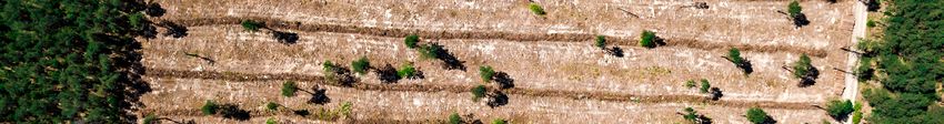
1WHAT IS FOREST DEGRADATION?
This project defines forest degradation as the partial loss of forest biomass. Figure 1 provides
a simplified view of this process. Starting with an undisturbed forest, degradation undermines
the integrity of forest cover via the gradual loss of vegetation over time. Although a degraded
forest still retains primary vegetation, it does not have the same forest structure, resilience,
and functions as an undisturbed forest.5 As degradation progresses, the loss of forest biomass
approaches that of clear-cut deforestation, in which there is complete (or near complete)
removal of all vegetation cover.
WHAT1.ISForest
Figure DEGRADATION ? and Clear-cut Deforestation
Degradation
1. Undisturbed forest 2. Early stage of degradation
3. Advanced stage of degradation 4. Clear-cut deforestation
Source: CPI/PUC-Rio, 2021
Source: Climate Policy Initiative
5 Longo, Marcos et al. “Aboveground biomass variability across intact and degraded forests in the Brazilian Amazon”. Global Biogeochemical Cycles
30, No. 11 (2016): 1639-1660.
2The process depicted in Figure 1, in which an undisturbed forest undergoes several stages
of degradation culminating in clear-cut deforestation, is just one of the possible paths for a
degraded area. Degradation can occur more or less gradually over time, depending on the type of
activity causing it. Moreover, degradation does not necessarily lead to clear-cut deforestation – a
degraded area can be intentionally maintained with only a partial remnant of primary vegetation,
or it might experience regeneration and contain a mixture of primary remnants and secondary
vegetation.
DEGRADATION IN THE BRAZILIAN AMAZON
PRIMARY CAUSES
The practices most commonly associated with tropical degradation in Brazil are selective
logging and forest fires. Selective logging entails the cutting of specific species of trees, typically
selected based on the commercial value of their timber. In addition to the loss of biomass from
tree extraction itself, the forest around felled trees is also compromised by the opening of access
roads and storage yards and by the damage caused by trees falling on nearby vegetation. To
minimize this side effect, lawful logging activities should abide by a management plan.
Fires, on the other hand, usually destroy the more fragile plants first and, after repeated burn
cycles in the same location, advance to more resistant plants. Due to high humidity, tropical
forests do not burn easily or right away. Upon first contact, fires consume the most fragile
vegetation and compromise the resilience of the remaining plants, which become more
vulnerable to subsequent fires.
The analysis by CPI/PUC-Rio uses data from DEGRAD, a system developed by Brazil’s National
Institute for Space Research (Instituto Nacional de Pesquisas Espaciais - INPE) that uses satellite
imagery to compile annual maps of degraded areas across the Brazilian Amazon from 2007
to 2016. DEGRAD does not consistently categorize the type or stage of degradation, so the
empirical analysis does not currently cover any such classification.
GENERAL CHARACTERISTICS
Forest degradation is a large-scale phenomenon in the Amazon, typically affecting a much
greater area than clear-cut deforestation. Between 2007 and 2016, an average 11,000 km2
of forest were degraded each year. This is twice the annual average for deforested areas in the
same period. While deforestation advanced at a relatively stable pace during the sample period,
degradation varied considerably over time, especially from 2009 to 2016. Total degraded area
per year varied from a minimum of 2,700 km² in 2014 to a peak of 23,700 km² in 2016.
3Spatially, forest degradation is geographically concentrated along the Arc of Deforestation,
which historically also holds most of the Amazon’s deforested areas.6 On average, the states of
Mato Grosso and Pará jointly account for 75% of degraded areas and 64% of deforested areas
per year in the Amazon. Despite the phenomenon’s regional concentration, degradation exhibits
a low rate of local recurrence over the years. A given area is classified as degraded, on average,
only once in the sample period.
Furthermore, there seems to be relatively little conversion from degradation to deforestation in
the Amazon as a whole during the period under assessment. On average, only 9% of degraded
areas are deforested within three years, which is the average length of time between the
occurrence of these two events. This, however, does not mean that a close relationship between
degradation and deforestation does not exist. Since this number is an Amazon-wide average, it
may hide important differences in how stakeholders interact with the forest in specific regions.
Land tenure plays a potentially central role in this. In Brazil, tenure is a key determinant of the
rules that govern local land use, including the protection and conversion of native vegetation.
Tenure-based governance structure may therefore affect land use decisions and, thus, local forest
conversion patterns. This calls for a better understanding of the relationship between degradation
and deforestation across different land tenure categories.
DEGRADATION AND DEFORESTATION BY LAND TENURE CATEGORY
By looking at how degradation and deforestation relate in different categories of land tenure, the
study aims at exploring whether governance structure influences local stakeholders’ interactions
with the forest. The analysis considers seven categories: small private properties, medium or
large private properties, protected territories (protected areas and indigenous lands), rural
settlements, undesignated public lands, unidentified lands (for which no information on tenure is
available), and others (remaining categories).
6 The Arc of Deforestation refers to a wide region of the Amazon biome that extends from western Maranhão and southern Pará towards the west,
passing through Mato Grosso, Rondônia, and Acre.
4Figure 2a. Deforestation, Distribution by Land Tenure Category, 2007-2018
Figure 2a. Deforestation, Distribution by Land Tenure Category, 2007-2018
100
90
80
70
Fraction of Deforested Area (%)
60
50
40
30
20
10
0
2007 2008 2009 2010 2011 2012 2013 2014 2015 2016 2017 2018
Year
Small Private Property Rural Settlement Undesignated Area Others
Medium/Large Private Property Protected Territory Unidentified Area
Source: CPI/PUC-Rio with data from PRODES/INPE, Agricultural Atlas/IMAFLORA, and National Registry of
Source: CPI/PUC-Rio with
Public Forests/Brazilian data Service,
Forest from PRODES/INPE,
2021 Agricultural Atlas/IMAFLORA, and National Registry of
Public Forests/Brazilian Forest Service, 2021
5Figure 2b. Degradation, Distribution by Land Tenure Category, 2007-2016
Figure 2b. Degradation, Distribution by Land Tenure Category, 2007-2016
100
90
80
70
Fraction of Degraded Area (%)
60
50
40
30
20
10
0
2007 2008 2009 2010 2011 2012 2013 2014 2015 2016
Year
Small Private Property Rural Settlement Undesignated Area Others
Medium/Large Private Property Protected Territory Unidentified Area
Source:CPI/PUC-Rio
Source: CPI/PUC-Riowithwithdata
datafrom
fromDEGRAD/INPE,
DEGRAD/INPE,Agricultural
AgriculturalAtlas/Imaflora,
Atlas/IMAFLORA, and National
and National Registry
Registry of
of Public
Forests/Brazilian Forest Service,
Public Forests/Brazilian Forest 2021
Service, 2021
Figure 2 shows the annual distribution of deforestation and degradation across categories.
For deforestation, the distribution remains quite stable over time, with similar shares of forest
loss occurring every year in private properties (mainly medium or large), rural settlements and
undesignated public lands. Degradation, on the other hand, varies significantly across categories
and years. A large share of degradation occurs in medium or large private properties and, to a
lesser extent, in unidentified lands. The lower participation of small private properties and rural
settlements, as well as the greater participation of protected territories contrast with the pattern
seen for deforestation.
6Figure 3. Relationship Between Degradation and Deforestation by Land Tenure Category, 2007-2015
Figure
Figure 3.
3. Relationship
Relationship Between
Between Degradation
Degradation and
and Deforestation
Deforestation by
by Land
Land Tenure
TenureCategory,
Category,2007-2015
2007-2015
HOW TO READ THE GRAPH?
HOW TO READ THE GRAPH? Of all sites degraded in 2007, 30% were also
Example Land Tenure Category
deforested
Of all within in
sites degraded the next 30%
2007, threewere
yearsalso
Example Land Tenure Category (in 2008,within
2009the
or 2010).
deforested next three years
70 (in 2008, 2009 or 2010).
Fraction of Degraded Area (%)
70 60
Fraction of Degraded Area (%)
60 50
50 40 Of all sites degraded in 2007, 50% were either
40 30 deforested
Of all or sawinnearby
sites degraded 2007, deforestation within
50% were either
the next or
deforested three
sawyears
nearby(in deforestation
2008, 2009 orwithin
2010) –
30 20
the30%
next had
threeon-site deforestation
years (in 2008, 2009and 20% had
or 2010) –
20 10 30%deforestation
had on-site happening
deforestationwithin
and 0.5
20% km.
had
10 0 deforestation happening within 0.5 km.
0
2007
2008
2009
2010
2011
2012
2013
2014
2015
Of the degraded sites in 2007, 70% were
2007
2008
2009
2010
2011
2012
2013
2014
2015
either
Of the deforested
degraded sitesor
in saw nearby
2007, 70% deforestation
were
within the next three years (in 2008, 2009 or
either deforested or saw nearby deforestation
2010)
within 30%three
the–next had on-site
years (indeforestation,
2008, 2009 or 20%
Year in which degradation had–deforestation
2010) happening
30% had on-site within 0.5
deforestation, 20% km
occurred and 20% had deforestation happening
Year in whichwithin example
degradation had deforestation happening within 0.5 km
land tenure
occurred withincategory
example andbetween
20% had0.5 km and 1 km.happening
deforestation
land tenure category between 0.5 km and 1 km.
Small Private Property Medium/Large Private Property Rural Settlement
Small Private Property Medium/Large Private Property Rural Settlement
70
70 60
60 50
50 40
40 30
30 20
Fraction of Degraded Area (%)
Fraction of Degraded Area (%)
20 10
10 0
0
Protected Territory Undesignated Area Unidentified Area
Protected
70 Territory Undesignated Area Unidentified Area
70 60
60 50
50 40
40 30
30 20
20 10
10 0
2007
2008
2009
2010
2011
2012
2013
2014
2015
2007
2008
2009
2010
2011
2012
2013
2014
2015
2007
2008
2009
2010
2011
2012
2013
2014
2015
0
2007
2008
2009
2010
2011
2012
2013
2014
2015
2007
2008
2009
2010
2011
2012
2013
2014
2015
2007
2008
2009
2010
2011
2012
2013
2014
2015
Year
On-site degradation and Year
On-site degradation and nearby On-site degradation and nearby
deforestation
On-site degradation and On-site degradation and 0.5
deforestation (within km)
nearby deforestation
On-site (within
degradation and 1nearby
km)
deforestation deforestation (within 0.5 km) deforestation (within 1 km)
Note: For each land tenure category, the graph shows the share of area degraded in each year that was followed
Source: CPI/PUC-Rio with data from DEGRAD/INPE, Agricultural Atlas/Imaflora, and National Registry of Public
by Forests/Brazilian
deforestation within three years.2021
Forest The analysis considers deforestation happening in the same site as degradation
Source: CPI/PUC-Rio withService,
data from DEGRAD/INPE, Agricultural Atlas/Imaflora, and National Registry of Public
(conversion of degradation
Forests/Brazilian to deforestation)
Forest Service, 2021 and in its vicinity (deforestation near degradation).
Source: CPI/PUC-Rio with data from DEGRAD/INPE, PRODES/INPE, Agricultural Atlas/IMAFLORA, and National
Registry of Public Forests/Brazilian Forest Service, 2021
7Does deforestation systematically follow degradation in any of the land tenures categories?
Figure 3 suggests it does. Although the local conversion of degradation into deforestation
remains low or moderate across all tenure categories, the data point to significant deforestation
occurring near degraded areas within three years of the degradation event. In this sense,
degradation in a given site may not always be a precursor to on-site deforestation, but it may
serve as an indicator that deforestation will soon occur in that region.
As Figure 3 shows, the relationship between degradation and deforestation varies among
land tenure categories. Although it is impossible to determine the reasons for these
differences from the data used in the study, the analysis raises a few likely interpretations.
There are three main patterns. First, the conversion of degradation into deforestation
is consistently low within protected territories, even when accounting for deforestation
occurring in the vicinity of degraded areas. Considering that environmental crimes
committed inside protected territories are subject to harsher penalties, the low conversion
rates could be explained by the fact that removing more vegetation in degraded areas, which
carries a greater risk of detection by environmental law enforcement authorities, is simply
not worth it.
Second, degradation appears to be followed by nearby deforestation in small private properties
and rural settlements. In these categories, even local conversion from degradation to
deforestation is relatively high. This pattern is likely tied to the high cost of clearing vegetation
in a tropical forest. For smallholders and settlers, who typically have limited access to financing,
degradation might provide a way to remove forest cover little by little and at a lower cost.
Third, medium and large private properties, undesignated public areas, and unidentified areas
seem to lie somewhere in-between the two previous patterns. Local conversion of degradation
into deforestation is low, but there appears to be a moderate portion of degraded areas that are
followed by nearby deforestation. These categories are less homogeneous than the previous
ones, so this pattern likely encompasses a variety of degradation and deforestation profiles.
Finally, the evidence suggests that the share of degradation followed by on-site or nearby
deforestation grew in the final years of the sample across all land tenure categories. This may
point to degradation as an increasingly relevant precursor to – and therefore an important leading
indicator of – deforestation.
NEXT STEPS FOR RESEARCH AND PUBLIC POLICY
Forest degradation appears to be closely related to deforestation in the Brazilian Amazon,
and, for select land tenure categories, it seems to be a precursor of deforestation. Degradation
can therefore be used as an indicator of imminent environmental damage and help target
conservation policy efforts. On the other hand, for cases in which degradation does not convert
to deforestation, it is important to understand why the degradation of environmental assets is
happening if the land is not being subsequently used for production.
In this setting, public policies must tailor approaches to address the various forest conversion
practices found across different land tenure categories. Research, in turn, must support public
policy design and implementation by advancing the understanding of how tenure-based
8governance structures influence patterns of degradation and subsequent deforestation. This
study offers a first look at how policymakers can understand degradation and use this knowledge
to enhance their ability to combat forest loss in its various forms.
DATA
The analysis explores a rich and spatially explicit (raster) dataset built from a variety of publicly
available sources. The key variables and their sources are: degraded areas from DEGRAD/INPE;
deforested areas from PRODES/INPE; and land tenure categories from the Agricultural Atlas/
IMAFLORA and National Registry of Public Forests/Brazilian Forest Service.
METHODOLOGICAL NOTE
The analysis aims at empirically characterizing forest degradation in the Brazilian Amazon and
investigating its relationship with clear-cut deforestation between 2007 and 2018. The spatial
sample includes tropical forest areas in the Brazilian Amazon Biome that were degraded and/
or deforested during the sample period. A raster database was compiled at 30-meter resolution
to include georeferenced data on degradation and deforestation over time, as well as on land
tenure categories for the entire Amazon Biome. The study relates degradation and deforestation
events happening in the same place or in close proximity, and stratifies the results by land tenure
category. Due to the large number of observations in the database (almost 2 billion), random
sampling was used to build the dataset for analysis (containing 2.5% to 15% of all observations in
the original database).
9AUTHORS
CLARISSA GANDOUR
Head of Policy Evaluation, Conservation, CPI/PUC-Rio
clarissa.gandour@cpiglobal.org
DIEGO MENEZES
Analyst, Conservation, CPI/PUC-Rio
JOÃO PEDRO VIEIRA
Analyst, Conservation, CPI/PUC-Rio
JULIANO ASSUNÇÃO
Executive Director, CPI/PUC-Rio
Suggested Citation
Gandour, Clarissa, Diego Menezes, João Pedro Vieira, and Juliano Assunção. Forest Degradation in the Brazilian Amazon:
Public Policy Must Target Phenomenon Related to Deforestation. Rio de Janeiro: Climate Policy Initiative, 2021.
MARCH 2021
Climate Policy Initiative (CPI) is an analysis and advisory organization with deep expertise in finance and policy. Our mission is to help
governments, businesses, and financial institutions drive economic growth while addressing climate change. In Brazil, CPI partners with the
Pontifical Catholic University of Rio de Janeiro (PUC-Rio). This work is funded by Norway’s International Climate and Forest Initiative (NICFI)
and Instituto Clima e Sociedade (iCS). This publication does not necessarily represent the view of our funders and partners.
Contact CPI Brazil: contato.brasil@cpiglobal.org
www.climatepolicyinitiative.org
Content licensed under Creative Commons Attribution 4.0 International. The texts in this publication may be reproduced in whole
or in part provided that the source and the respective authors are cited.
10You can also read