Cycling infrastructure in the Ottawa-Gatineau area: a complex assemblage of data
←
→
Page content transcription
If your browser does not render page correctly, please read the page content below
Cycling infrastructure in the Ottawa-Gatineau area: a complex assemblage of
data
Sylvie Lafortune1, Joël Rivard2

Abstract
The Ottawa-Gatineau National Capital Region (Canada) has a well developed and well used cycling
network of over 1,000 km which spans both sides of the Ontario and Quebec provincial boundary.
The purpose of this study is to map out the complex data landscape behind the cycling infrastructure
in the National Capital Region (NCR), which is largely based on inter-jurisdictional cooperation and
partnerships with cycling advocacy groups. The questions we try to answer are: What data are
collected for cycling infrastructure and activities? Who are the data producers and stakeholders?
What are the relationships amongst the various data producers and stakeholders? The study reveals
that the complexity of the cycling data landscape in the NCR is due to the complexity of the
relationships between the various data producers and stakeholders.

Keywords
Cycling infrastructure data, cycling advocacy, cycling data stakeholders, cycling data producers,
National Capital Region (Canada), active transportation data

Introduction
This article is based on the results of an exploratory study conducted in 2017-2018 and presented as
a poster at the IASSIST 2018 conference in Montreal, Canada. The theme of the conference was
‘Once upon a data point: sustaining our data storytellers’ and it provided us with a great opportunity
to explore the data story behind the cycling infrastructure in Ottawa, Canada’s capital city.

We felt that our topic was particularly timely as we had noticed a heightened interest in active
transportation research over a number of years. This became apparent with an increase in requests
for cycling data which, we might add, are frequently difficult to obtain. As a result, the overall goal of
our study was to get a better understanding of the data collected to build and maintain the cycling
network in the National Capital Region (NCR). We chose this geographic region for the following two
reasons:

     1. The NCR is an interesting and possibly unique location to examine because it is situated
        across two cities (Ottawa and Gatineau) as well as two Canadian provinces (Ontario and
        Quebec). It is also managed by a federal commission which is described below. These five
        bodies are governed in different ways and follow their own processes for collecting,
        managing and sharing active transportation data.

     2. Most of the requests we get for cycling data are generally limited to the NCR, which is where
        both of our universities are based and where our users are conducting research.

1/8 Lafortune,Sylvie and Rivard, Joël (2018) Cycling infrastructure in the Ottawa-Gatineau area: a complex assemblage of data, IASSIST
Quarterly 42 (4), pp. 1-8. DOI: https://doi.org/10.29173/iq937
Background and purpose of the study
The National Capital Region has a well developed and well used cycling network of over 1,000 km of
cycling routes which spans both sides of the Ontario and Quebec provincial boundary. The cycling
network started in the 1980s when the National Capital Commission (federal government) secured
the majority of industrialized waterfront lands as public land to create public green spaces, acquired
a vast area in the Gatineau Hills to create a federal park, and established the 203-square-kilometre
National Capital Greenbelt around Ottawa.3
Over the past two decades the Ottawa-Gatineau area has seen continued growth in cycling
infrastructure but according to Citizens for Safe Cycling, an active advocacy group in Ottawa, there
has been ’decades of under-investment in active transportation which means that there is a lot of
catching up to do’.4
In the past few years, governments in Canada have followed the sustainable transportation
development trend and shifted funding in this direction. As a result, municipalities such as Ottawa
have made strategic decisions to further invest in cycling infrastructure. These include expanded and
improved bike lanes and paths, traffic calming measures, parking facilities, bike-transit integration,
bike sharing and training programs to promote cycling and increased cycling safety.
The purpose of this exploratory research is to gain a better understanding of the data landscape
behind the cycling infrastructure in the Ottawa-Gatineau area which is largely based on inter-
jurisdictional cooperation and partnerships with cycling advocacy groups. The questions we try to
answer are:
1. What data are collected for cycling infrastructure and activities?
2. Who are the data producers and stakeholders?
3. What are the relationships amongst the various data producers and stakeholders?
Methodology
Given the scope of this study, we decided to conduct a website content analysis. We began with a
general web search on cycling infrastructure in the Ottawa-Gatineau area. This led to the web sites
and planning documents issued by the governments that have jurisdiction over this region: the City
of Ottawa, the Ville de Gatineau and the National Capital Commission. From these webpages, other
data stakeholders such as the TRANS Committee, Bike Ottawa, Action vélo Outaouais and VeloGO
emerged and were further explored.
To validate information found on these web pages and documents, certain individuals were
contacted to verify the accuracy of the information. We then compiled the types of cycling data
produced and which organization was producing the data. Finally, we attempted to establish the
relationships between the various data producers and the stakeholders.
2/8 Lafortune,Sylvie and Rivard, Joël (2018) Cycling infrastructure in the Ottawa-Gatineau area: a complex assemblage of data, IASSIST
Quarterly 42 (4), pp. 1-8. DOI: https://doi.org/10.29173/iq937Findings
A. Data collected
The following briefly describes the various data which contribute to the cycling infrastructure in the
Ottawa-Gatineau area, including how they are collected and who collects them.
Public Consultations
Public consultations are regulatory means of getting feedback from the general public about cycling
and its infrastructure in the national capital area. These include in-person and online consultations
to help organizations draft reports and plan for future directions. Target audiences for public
consultations on cycling include residents from both Ottawa and Gatineau and are conducted by
various organizations such as the City of Ottawa, the City of Gatineau and the National Capital
Commission (NCC).
Rapport sur l’état du vélo à Gatineau en 2015
A comprehensive report on cycling in the Ville de Gatineau in the province of Quebec. This is
produced by Vélo Québec which draws from a province-wide survey of cycling practices in Quebec,
with a sample of 400 respondents for the Ville de Gatineau. The report also includes an analysis of
the 2005 and 2011 Origin-Destination surveys of the Ottawa-Gatineau agglomeration.
Origin-Destination Survey
The Origin-Destination (O-D) Survey, held every five years, examines the “who, where, why, when,
and how” of transportation trips made by residents of the National Capital Region (NCR) resulting in
extensive, up-to-date information on current daily trip patterns of area residents.The survey is
conducted through voluntary, confidential telephone interviews over a 12-week period by a team
hired by the TRANS committee, the organization responsible for administering the survey. The
survey is conducted at the beginning of fall because during this period trip patterns are usually more
stable than at other times of the year. Results from the 2005 and 2011 survey are available on the
TRANS committee webpage. The next survey will take place once the first stage of implementation
of the light-rail has been implemented at the City of Ottawa.
User-generated active transportation data
Data generated by users when they sign up to use a mobile app that publicly tracks bicycle rides,
runs and other fitness activities. The data can be uploaded and become part of anonymized datasets
which are licensed to city planning groups. Strava Metro is one of the leading companies which
collect user-generated active transportation data. The City of Ottawa, the Ville de Gatineau and the
NCC share a Strava Metro account.
Cartographic data
These include geospatial data, maps (paper and digital) as well as interactive maps that have been
created by various local organizations.The cartographic products are used to illustrate the historical,
current and future cycling infrastructure in the NCR.
Quality of Facilities Measure
Currently, a small-scale preliminary ‘quality of facilities measure’ study is being conducted in the City
of Ottawa. It uses the Level of Traffic Stress (LTS) methodology to determine the actual and
perceived level of safety of the cycling infrastructure. It uses road characteristics such as vehicle
3/8 Lafortune,Sylvie and Rivard, Joël (2018) Cycling infrastructure in the Ottawa-Gatineau area: a complex assemblage of data, IASSIST
Quarterly 42 (4), pp. 1-8. DOI: https://doi.org/10.29173/iq937speed, number of vehicle lanes, and the presence of parking to determine the quality for a particular
segment.
Collision Data
The annual collisions report provides data on all reported collisions, including bicycles, on roads
within the jurisdiction of the City of Ottawa. It should be noted that during our research (spring
2018), this data was only found on the City of Ottawa’s Open Data portal. When searching the City of
Gatineau’s Open Data portal, the data was not available. No further steps were taken to confirm
whether or not this data existed for the City of Gatineau.
Post-infrastructure implementation survey
These are online surveys conducted to get a better understanding of the travel behavior of cyclists
once the cycling infrastructure is established. These surveys are part of a larger consultation process
conducted through meetings or email.
Bike Counters
Infrastructure that collects the number of times a bicycle crosses the counter (both directions
summed unless otherwise noted) at various locations in the NCR.
B. Organizations
Data Producers
National Capital Commission (NCC)
The National Capital Commission is a federal Crown corporation created by Canada’s Parliament in
1959 under the National Capital Act. The NCC is subject to the accountability regime set out in Part X
of the Financial Administration Act. It reports to Parliament through the minister designated as
minister responsible for the National Capital Act. The NCC is the main federal urban planner in
Canada’s Capital Region. In this role, the NCC works in collaboration with stakeholders to enhance
the natural and cultural character of the Capital. The NCC manages 236 kilometres of the pathways
in the Ottawa-Gatineau region, which extend from Gatineau Park, through Ottawa and into the
Greenbelt.
City of Ottawa
The City of Ottawa’s land area covers 2,792 km2 with a population of 934,243 in 2016. It operates
under the Ontario Municipal Act and the City of Ottawa Act, both overseen by the Ontario Ministry
of Municipal Affairs. In 2013, the city added an extensive cycling plan to the Building a Liveable
Ottawa 2031 report, which was a city-wide review of land use, transportation and infrastructure
policies, launched in 2012. In 2015, the city owned and maintained a cycling network of 700 km.
According to Bike Ottawa, the City of Ottawa has budgeted approximately $25 M in 2018 for cycling-
related projects.
Ville de Gatineau
The Ville de Gatineau spans a territory of 343 km2 with a population of 276,245 in 2016. It operates
under the Cities and Towns Act and the Charter of Ville de Gatineau, both overseen by the Ministère
des Affaires municipales et de l’Occupation du territoire du Québec. The city is currently creating its
first cycling network master plan which is expected to be adopted in 2018-2019. This master plan
will update the 2013 Plan de déplacements durables. In 2015, the city offered a cycling network of
269 km. According to the 2018 Ville de Gatineau budget, $7.5M will be available for the
4/8 Lafortune,Sylvie and Rivard, Joël (2018) Cycling infrastructure in the Ottawa-Gatineau area: a complex assemblage of data, IASSIST
Quarterly 42 (4), pp. 1-8. DOI: https://doi.org/10.29173/iq937development of the cycling network and an extra $1.4M per year afterwards. Additionally, the Ville
de Gatineau has planned to spend $470K annually for the cost of maintenance of the cycling
network.
TRANS Committee
The TRANS Committee was established in 1979 to coordinate efforts between the major
transportation planning agencies of the National Capital Region. The Committee is a neutral forum
for the exchange of information on technical guidelines and best practices. In addition, it manages
transportation studies and collects data for transportation planning. The six members of the
committee span all three levels of government. They include the National Capital Commission, the
ministère des Transports, de la Mobilité durable et de l'Électrification des transports du Québec, the
Ministry of Transportation of Ontario, Ville de Gatineau, the City of Ottawa, and the Société de
transport de l’Outaouais. Funding responsibilities are shared by the six member agencies. The
proportion of contributions may vary for some projects.
Stakeholders
Bike Ottawa
Bike Ottawa (also known as Citizens for Safe Cycling) is a cycling advocacy group established in 1984
and based in Ottawa. According to its website, this organization promotes “cycling as a safe, fun, and
environmentally friendly form of transportation.” The organization has a strong volunteer base
involved in writing letters to city councillors, participating in city consultations, gathering and
analyzing data from Statistic Canada, the Ottawa Cycling Plan, bike counters, Transport Canada as
well as Weather Canada to promote safe cycling and cycling as active transportation.
Action vélo Outaouais
Action vélo Outaouais is a cycling advocacy group based in Gatineau. According to its website, the
focus of this group is on the planning and development of a safe cycling network in the Outaouais
region (including the Ville de Gatineau). Action vélo Outaouais partners with the Ville de Gatineau by
networking with cycling groups in the Gatineau area to gather feedback on cycling projects and by
submitting briefs and reports to the city. It partners closely with Vélo Québec, a long-standing
provincial cycling advocacy group which produces detailed cycling reports at the regional level in the
province. The organization is also involved in promoting active transportation, recreational cycling
and cyclotourism, as well as finalizing the development of the Route Verte (cycling infrastructure
throughout the province of Québec).
Bicycle-sharing program
A service in which bicycles are made available for shared use to individuals on a very short term
basis, for a fee. VeloGo is the official bicycle-sharing program for the Ottawa-Gatineau area and it
uses “smart-bikes” which come equipped with real-time GPS, GSM, RFID and NFC technologies. This
program is a public-private partnership between CycleHop, the City of Ottawa, the National Capital
Commission and the Ville de Gatineau. Cyclehop shares its VeloGO GPS data with its partners.
C. Relationships
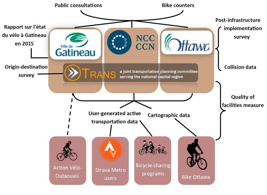
An important insight offered by this study is that the complexity of the cycling data landscape in this
area is largely due to the complexity of the relationships between the various data producers and
5/8 Lafortune,Sylvie and Rivard, Joël (2018) Cycling infrastructure in the Ottawa-Gatineau area: a complex assemblage of data, IASSIST
Quarterly 42 (4), pp. 1-8. DOI: https://doi.org/10.29173/iq937stakeholders. Most relationships were outlined above, but to get a deeper understanding of the
actual collaboration between organizations, we created the diagram below.
Relationships amongst the producers and stakeholders of data
Further observations
The National Capital Region (NCR) is a unique geographic area in Canada, where two provinces, two
municipalities, and one federal organization must work together to develop a safe and sustainable
cycling infrastructure for the residents and visitors who travel within and between both
municipalities and federal parks. The cycling data landscape is further complicated by an increasing
number of stakeholders such as cycling activist groups and bike sharing companies who have an
obvious interest in promoting and challenging transportation projects which involve cycling. Finally,
an additional challenge in the NCR is that the infrastructure must be implemented in either one or
both of Canada’s official languages.
However, we found that the intricate nature of the region is somewhat counterbalanced by a long-
standing formal culture of data sharing through the TRANS Committee as well as an informal one
between the various stakeholders (users and data producers). In an era of growing active
transportation and open government, how these relationships evolve could be further explored.
However, and not surprisingly, we noted that each of the three jurisdictions in the NCR operates
independently and information on their cycling planning is not always publicly available in the same
manner.
6/8 Lafortune,Sylvie and Rivard, Joël (2018) Cycling infrastructure in the Ottawa-Gatineau area: a complex assemblage of data, IASSIST
Quarterly 42 (4), pp. 1-8. DOI: https://doi.org/10.29173/iq937Further studies on how the NCR stakeholders use and combine the various cycling datasets, more specifically the user-generated active transportation data, to improve infrastructure should also be considered. Finally, further investigation on how infrastructure decisions are actually arrived at would require interviews with the data producers and stakeholders. References Bike Ottawa (2018) ‘Bike Ottawa Annual Report 2018’. Accessed 20 April 2018 https://drive.google.com/file/d/1BZUzvxBhT2slD-6EkVBLvQ4AtE6hbKis/view City of Ottawa (2013) ‘Ottawa Cycling Plan’. Ottawa: City of Ottawa. Accessed 22 November 2017 https://documents.ottawa.ca/sites/documents.ottawa.ca/files/documents/ocp2013_report_en.pdf National Capital Commission (2018) ‘Capital Pathway Strategic Plan’. Ottawa: National Capital Commission. Accessed 15 February 2018 http://ncc-ccn.gc.ca/our-plans/capital-pathway-strategic-plan O-D Survey. (2018) ‘TRANS Committee’. Ottawa: Trans Committee. Accessed 15 February 2018 http://www.ncr-trans-rcn.ca/surveys/o-d-survey/ Ville de Gatineau (2018) ‘Gatineau, ville vélo’. Gatineau: Ville de Gatineau. Accessed 12 November 2017 https://www.gatineau.ca/portail/default.aspx?p=transport_voirie/velo Ville de Gatineau (2018) ‘Plan directeur du réseau cyclable’. Gatineau: Ville de Gatineau. Accessed 12 November 2017 https://www.gatineauvillevelo.ca/ Vélo Québec (2015) ‘L’Etat du vélo à Gatineau en 2015’. Accessed October 25 2017 https://www.gatineau.ca/docs/transport_voirie/velo/etat_velo_2015.fr-CA.pdf 7/8 Lafortune,Sylvie and Rivard, Joël (2018) Cycling infrastructure in the Ottawa-Gatineau area: a complex assemblage of data, IASSIST Quarterly 42 (4), pp. 1-8. DOI: https://doi.org/10.29173/iq937
End-notes

1Sylvie Lafortune is a Social Sciences Librarian at Carleton University, Ottawa, Canada. Her
email address is: sylvie.lafortune@carleton.ca.
2
 Joel Rivard is the Geography and GIS Librarian at the University of Ottawa, Canada. His
email address is: joel.rivard@uottawa.ca

3
 Canada. National Capital Commission. A Legacy to Build On, Accessed November 11,
2017, http://capital2067.ca/legacy/

4
 Citizens for Safe Cycling, 2017 Ottawa Report on Bicycling, Accessed November 11, 2017,
https://bikeottawa.ca/images/Cycling_Reports/2017_Ottawa_Report_Bicycling_FINAL.pdf

8/8 Lafortune,Sylvie and Rivard, Joël (2018) Cycling infrastructure in the Ottawa-Gatineau area: a complex assemblage of data, IASSIST
Quarterly 42 (4), pp. 1-8. DOI: https://doi.org/10.29173/iq937
You can also read