OTematata MAsterplan 2020 - Waitaki District Council
←
→
Page content transcription
If your browser does not render page correctly, please read the page content below
1 | otematata masterplan 2020 OTematata MAsterplan 2020
Foreword from
                                           the Mayor
                                             “If you fail to plan, you are planning to fail”
                                                                                           - Benjamin Franklin

                   Benjamin Franklin’s words continue to be as relevant today as they ever were, and when it comes to
                   townships which are growing as Otematata and Ōmārama are, planning is crucial to ensure that that growth
                   is managed. The importance of good planning is not just for the new people who move to the townships and
                   the development they bring, it is even more important for the existing inhabitants of those communities.
                   I’m pleased with the masterplans presented in this document, and also with the way they were developed.
                   They are the result of very positive engagement with both communities, along with some very good work
                   by our planning team. These masterplans will help direct growth in ways which improves the liveability of
                   Ōmārama and Otematata, and which will help locals continue to enjoy the positive attributes of living in their
                   special part of Waitaki.
                   Council’s vision of making Waitaki a better place to live is embodied in these plans as we help to create great
                   places to live in. I look forward to seeing them implemented in the years to come!
                   Kind Regards,
                   Gary Kircher
                   Mayor for Waitaki

2   |   otematata masterplan 2020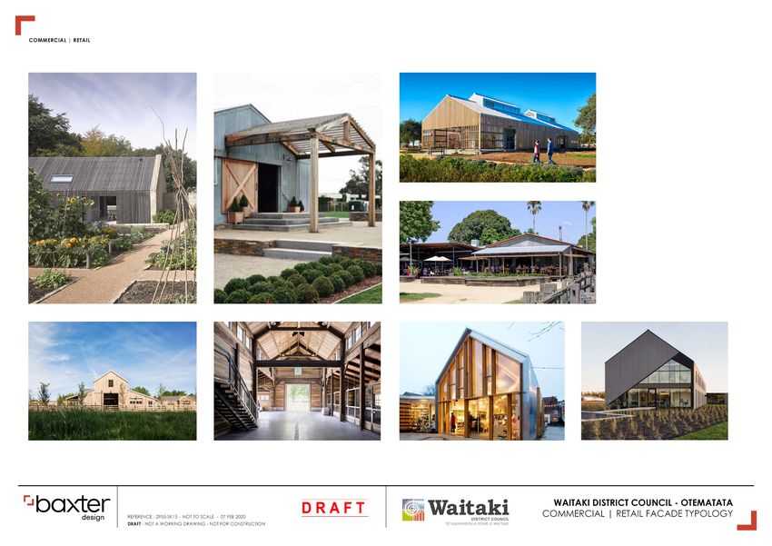
WHAT IS THE otematata MASTERPLAN?
        The Otematata Masterplan is a blueprint for long term growth and helps the
        community and Council plan for how Otematata will grow and change in the
        future.
        The Masterplan sets out the community’s vision for how it wants to see the town
        grow and where new houses, shops, community facilities, open spaces, trees,
        street furniture, car parks, pedestrian connections etc could go.
        The masterplan provides a spatial framework to guide future growth and
        development in Otematata.

        WHY DOES OTEMATATA NEED
        A MASTERPLAN?
        Waitaki District Council held a series of community visioning workshops as part of the Long Term Plan
        process in 2018. A strong theme emerged from these workshops that a town plan was needed for Otematata
        to better plan for development in the future given its increasing popularity and tourism growth. The
        development of a masterplan for Otematata was identified in the Council’s Long Term Plan for 2018-2028.

3   |   otematata masterplan 2020
HOW WAS THE MASTERPLAN
        DEVELOPED?
        In order to better understand what the community thinks and values about Otematata, Council held a series
        of drop-in sessions over January and February 2019, along with an opportunity for people to have their say
        via online and paper surveys. We also considered the feedback given at the Community Visioning workshops
        held in Otematata in 2018 as part of the Long Term Plan consultation.
        Accommodating increased pressures for growth and creating a viable township are presenting challenges
        for the community. Whilst Otematata has a small permanent resident population (186 as at 2013), there is a
        continued demand to build additional houses in the area. Undeveloped residential zoned land in Otematata
        is currently under Crown pastoral lease. This has created concerns about where additional residential
        development should happen and whether Otematata can support future growth. The area has seen a
        continued rise in tourism with the Alps to Ocean trail and increases in visitor numbers within the Waitaki
        Valley overall. The town will benefit from increased visitors to the Waitaki Whitestone Geopark and needs to
        be able to service tourism growth while at the same time building a resilient economy to encourage a larger
        permanent resident base in the area.

        Guiding Principles                                                                                                                 Becoming
                                                                                                                         More
        for Change                                                                                                     housing
                                                                                                                                           a vibrant
                                                                                                                                          community
                                                                                                                        choice              all year
        Waitaki District Council has worked with the community to identify the key issues facing                                             round
        the Otematata community. Talking with the community has helped identify three core
        issues the Masterplan should deal with.

                                                                                                                                  Improved
                                                                                                                                 appearance
                                                                                                                                 along State
                                                                                                                                 Highway 83

4   |   otematata masterplan 2020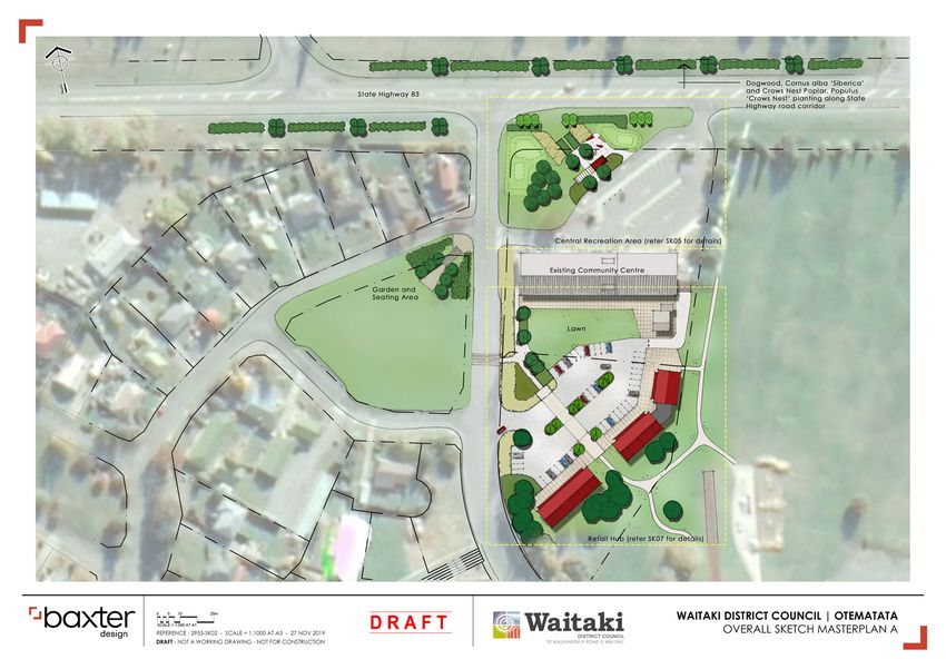
The options for Otematata:
        Three masterplan options were presented to the community for feedback and discussion during August/September 2019.
        The options were available online and a morning workshop was held in Otematata which was attended by over 75 members of the community. The options
        put forward were focused on the guiding principles for change and provided a basis for further discussion and agreement on how the final masterplan for the
        town should look. Further information on the options and background to the masterplan process can be found in more detail in the Masterplan Discussion
        Document which can be accessed here.

                                                                                   option 2                                                  option 3
                                                                    Additional retail, business                              More retail with new
                                                                    area and information zone                                business area and visitor
                                                                    The focus of this option is to have more                 accommodation.
                                                                    retail space south of State Highway                      The focus of this option is to expand the
                        option 1                                    83 with a new business area and
                                                                    information zone.
                                                                                                                             retail area north of State Highway 83
                                                                                                                             with a new business area and additional
                                                                                                                             visitor accommodation.

         Status quo with streetscape
         improvements
         This option keeps the status quo of
         zones and uses with improvements to
         the streetscape with better pedestrian
         links.

5   |   otematata masterplan 2020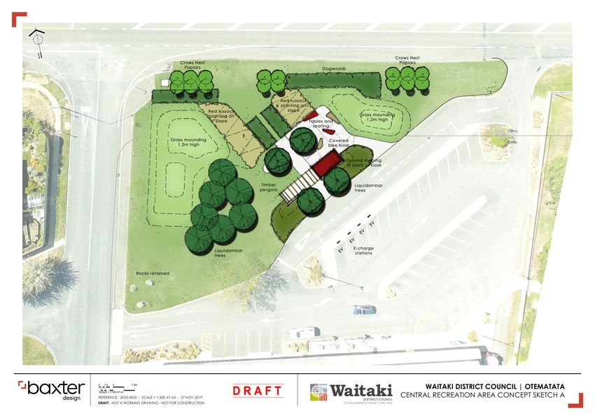
Community FeedbacK
We went out to the community and asked for their views on the three
masterplan options. The community gave us a clear direction on how
they want to see Otematata develop in the future.
Information on the feedback received from the community can be
found here.
TRANSPORT VISITOR
HOUSING RETAIL FACILITIES
here’s a LANDSCAPE/ Install a bike maintenance
snapshot of No clear consensus
on the location of future
Favoured location for more
Need to calm traffic speeds
either directly with speed
STREETSCAPE station on area to front of
retail behind the community
what you housing but Waitaki Drive centre and shop.
limits or indirect with calming
measures such as landscaping,
Strong support for gateway
community centre.
Electric charger for bikes
East and Loch Laird Road landscaping on approaches
told us at the sites were favoured. (Loch traffic islands. to town. Select plants that
and cars.
Laird site was favoured for Improved town signage. Develop heritage trail using
community mixed use development.)
COMMERCIAL Provide safe crossing point
are suitable to climate/
conditions and ensure QR codes.
workshop: Need for larger section
sizes to keep boats, trailers
from hotel to park (underpass
idea was popular)
they are maintained. Need
for professional and local
Provide an unmanned
information kiosk focus on
etc off the road (600m2 - Light industry and service knowledge to provide advice hydro and cultural heritage
800m2). activities at the Loch Laird on planting. of area.
Provide some limited Road site – mixed use site Hydro-history information
with some residential.
RECREATIONAL and sculpture on main
areas for higher density FACILITIES
housing but keep to a road. Placement of old dam
maximum of two storeys building machinery (possibly OTHER
No need for dog park from Twizel) had good
and ensure character of the
(already an existing one at support– great feature and for
town is retained.
Buller Crescent). kids to climb and explore. Need to ensure
Concerns that housing infrastructure provision
Enhance existing
will only be used for visitor is suitable before new
recreational areas with better
accommodation and not development planned.
lighting, planting (including
provide for an increased
fruit tree) and changing sheds.
resident population.
BBQ area at old toilet site
with shade sail and picnic
tables.
6 | otematata masterplan 2020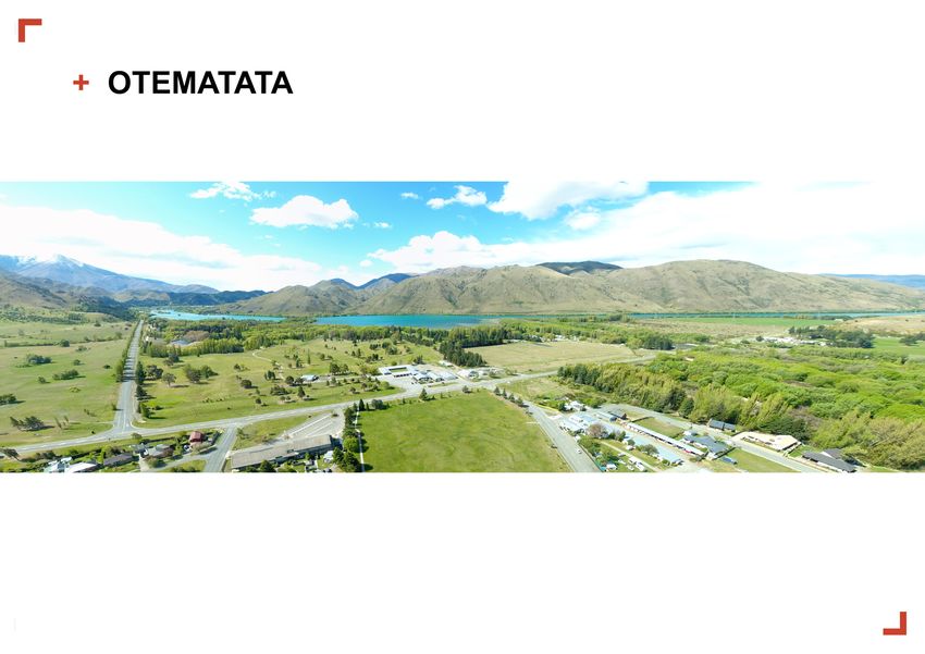
And here’s what you told us from your written feedback:
                      Most preferred OPTIONS                    			                       (listed in order of preference) 			                                       Least

                           1                  2                3                 4                   5                  6                    7                8                  9
                        Adventure          Establish a    Establishment         Small            Additional         Establish a        Establish a           Provide            Visitor
                        playground         hydro-dam      of community        business          commercial          new retail          new retail          a fenced       accommodation
                                            sculpture        gardens         area with               light          area along          area along          dog park        on West Road/
                            =                 at the                           shared             industrial       the frontage           the golf         within the         Rata Drive
                        A2O kiosk         intersection                       resources           land along           of the           course road         recreation          reserve.
                           at the         of SH83 and                                           River Terrace       recreation           frontage.            area
                       intersection
                          of West
                                           Loch Laird
                                              Road
                                                                                                                       area
                                                                                                                                             =
                                                                                                                                      Information/
                         Road and                                                                                                         hydro-
                         SH83 (in                                                                                                       heritage/
                          front of                                                                                                    A2O kiosk on
                        community                                                                                                      West Road/
                          centre).                                                                                                     Rata Drive
                                                                                                                                         reserve

                      These were your thoughts on where new housing should go:
                     Most preferred OPTIONS (listed in order of preference)

                                      1                                     2                                          3                                          4
                     Medium density housing off Waitaki        Low density housing off Kowhai            Medium density housing to south              Low density housing off Loch
                      Drive East (approx. 100 houses).           Place (approx. 20 houses).              of Otematata (approx. 250 houses)           Laird Road (approx. 50 houses)

7   |   otematata masterplan 2020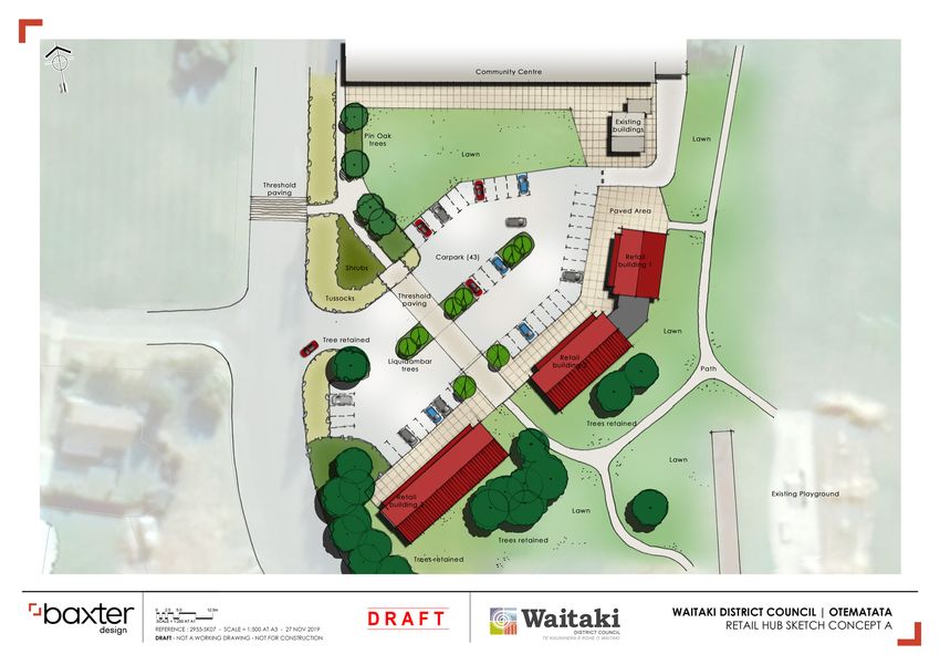
otematata Today                                                                                Relationship with
        Snapshot Stats
                                                                                                       other Plans and
                                                                                                       Strategies
                                                             Otematata has a resident population
                                                             of approximately 1861 . Otematata has     Figure 1 shows the relationship of the Otematata Masterplan with other Waitaki
                                                             seen significant growth and decline       District Council plans and strategies. It identifies which Council documents have
                                                                                                       helped develop the options presented in this document. It also shows how the
                                                             since the 1950s. At its peak (in 1966),
                                                                                                       Masterplan will feed into future Council plans and strategies.
                                                             4166 people lived in Otematata.

        There are approximately 460                                                                     DOCUMENTS THAT                                                      DOCUMENTS THE
                                                                                                        HAVE FED INTO THE                                                  MASTERPLAN WILL
        dwellings in Otematata. Additional                                                              MASTERPLAN                                                               FEED INTO
        residential developments are
        currently underway at Albert Place
                                                                                                       Long Term Plan 2018-28                                               Long Term Plan 2021-2031
        and The Dutch Way (formerly
        Otematata School).
                                                                                                                                                                                  District Plan Review
                                                              Otematata has a high proportion of       District Plan                                                            Inform future land use
                                                                                                                                                                                         development
                                                              unoccupied dwellings. Based on
        Very little resident population growth                2013 figures, there are 111 occupied
                                                                                                                                         OTEMATATA
        is anticipated in Otematata. Based on                 dwellings and 336 unoccupied
                                                                                                       Parks Strategy                    MASTERPLAN                                       Annual Plan
        recent low population growth rates,                   dwellings. This number may increase
        Otematata is projected to expand                      further with increased use of the                                                                                    Infrastructure Plan
        by up to 20 people by 20302. This                                                              Public Toilets Strategy
                                                              Alps to Ocean, Waitaki Whitestone
        figure does not factor in the expected                Geopark and other tourist attractions.                                                                          Guidance for the Ahuriri
        growth in holiday homes and visitor                   Otematata has the 8th highest level of                                                                               Community Board
        accommodation.                                                                                 Waitaki Reserves
                                                              unoccupied dwellings in NZ3.             Management Plan 2014
                                                                                                                                                                          Community Led Development
                                                                                                                                                                                         Programme

        Please note these figures are based on 2013 census data, best knowledge and                                                                                  Guidance for Private Developers
        information at the time of writing.
                                                                                                       Figure 1. Relationship of Masterplan to other Council documents.
        ___________________________________
        1.        Census 2013
        2&3.      Understanding Data Otematata Data Profile 2019

8   |     otematata masterplan 2020
Where we’re at in the
        Masterplan procesS
        We’ve listened to feedback from the community and had further discussions with the
        Ahuriri Community Board. Baxter Design Ltd were engaged to prepare the final documents
        for Otematata. These are now annexed to this document, along with ideas for future                 Community
        landscaping, building design, street furniture, signage and materials.                             Engagement
                                                                                                           June 2018: Community
                                                                                                           Visioning Workshops
                                                                                                           Jan 2019: Community
                                                                                                           engagement surveys and
                                                                                                 stage 1   drop-in sessions
                                               Draft Masterplan
                                               Options
                                               After talking with the
                                               community, we’ve identified a
                                               number of projects and ideas
                                               that are presented here as
                                                                                 stage 2
                                               masterplan options for the
                                               community to consider.                                      Preferred
                                                                                                           Masterplan Option
                                                                                                           August 2019: Consult with
                                                                                                 stage 3   the community to develop a

                                               Community                       we earree                   preferred masterplan option.

                                               Board & Council                  h
                                               approval
                                               December 2019: Ahuriri            stage 4
                                               Community Board to give
                                               further feedback on preferred
                                               masterplan option.
                                                                                                           Long Term Plan
                                               Jan/Feb 2020: Final approval
                                                                                                           and Annual Plan
                                               of masterplan by Ahuriri                          stage 5   Projects from the adopted
                                               Community Board and Waitaki                                 masterplan option will be
                                               District Council                                            fed into the Long Term Plan
                                                                                                           and Annual Plans if needed.
                                                                                                           Any re-zoning or land use
                                                                                                           requirements will be considered
                                                                                                           as part of the District Plan
                                                                                                           Review process.

9   |   otematata masterplan 2020
WHAT HAPPENS NEXT?
         The masterplan for Otematata was developed to assist in setting out the community vision for how and
         where the township will grow. A vision for the future supports the community to understand what future
         growth in the area could look like.
         The masterplan is not a ‘set in stone’ scenario, but an evolving vision that will change over time.
         The masterplan helps to identify key issues and priorities for the community and creates a blueprint for
         long term growth that helps us to plan for how Otematata could grow and evolve in the future.
         An opportunity to provide further feedback on the final masterplan will happen through the Long Term
         Plan and District Plan Review processes, and as the masterplan ideas are put in place.
         Implementation of the masterplan can’t be done by Council alone. It needs the commitment of the
         community, takata whenua, local organisations, private investors, the business community, other
         government and non-government agencies too. Whilst the Council will lead some actions, others will
         need to be led by the community and private sector.

                                                                                                                    MORE INFORMATION
                                                                                                                    You can find out more information on
                                                                                                                    the masterplan process by clicking
                                                                                                                    on the following link;
                                                                                                                    https://www.waitaki.govt.nz/
                                                                                                                    our-council/consultation/Pages/
                                                                                                                    Otematata-masterplan.aspx
10   |   otematata masterplan 2020
THE Otematata MASTERPLAN
The following draft Otematata Masterplan is a starting point. It’s an evolving
community document that relies on community support and vision for the future.
Hopefully it provides inspiration to the community and local developers to guide how
Otematata could grow into the future.
Visit https://www.waitaki.govt.nz/our-council/consultation/Pages/Otematata-
masterplan.aspx for more information and updates on the masterplan.
11 | otematata masterplan 2020OTEMATATA DESIGN STATEMENT
Otematata is surrounded by strong, open landscape, with the town set back from the state approximately 1000m2 of Retail/Commercial space, paved areas for
highway and facing the broad expanse of hills to the north of Lake Aviamore. With an abundance restaurants/café dining, and an open lawn space.
of space in the town, opportunities arise to define public spaces and create amenity. Residents
have identified the need to strengthen connections, form a well-planned retail hub and provide The second concept for the Retail Hub includes retail/commercial
sheltered space for visitors. space north of the Community Centre in a smaller capacity, balancing
the heritage/bike kiosk (mentioned previously) and the open space
As the speed through the town is 80km/ph, emphasis has been based on attempting to here. This concept allows for approximately 550m2 of Retail/
modulate traffic speed by clearly identifying the arrival and exit points into the town and Commercial space, 21 car parks (reduction of parks overall from the
reinforcing this throughout the township. This will help to encourage the sense of being in a existing), central lawn space with bike/heritage kiosk, and plantings
residential area. We noted the success of the small grassed area, canopied with trees – home of tussock, shrubs and trees. The space allows for visitors to see that
to a coffee cart, which has become a favoured stop off spot. We have attempted to echo this there is a place to stop to get a bit, relax, and learn about the history
with an informal public lawn space by the central car park. of the town, which frees up the land south of the Community Centre to
be developed as residential land with approximately 11 lots between
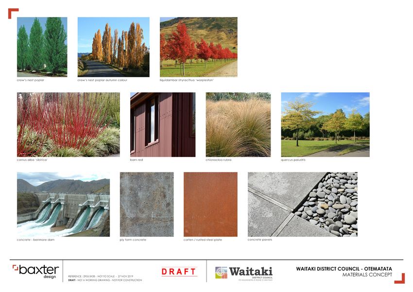
Bold planting features in the design, with two predominant species: Poplar trees in pairs and 400-600m2.
fours, and bold groups and borders of red bark Dogwoods. These trees and shrubs add bulk
and form to the town landscaping and are continued throughout the urban road corridor. These future developments each represent key aspects of the
Otematata community’s desire to strengthen the heart of the town,
We have referenced some current landscape elements in front of the Community Centre. provide for the A20 riders and supporters with bike/heritage kiosk,
These are the Liquidambar trees, Pin Oaks, Tussocks, and rocks. With the residents’ thoughts public space, and new retail/commercial areas, provide for future
in mind regarding the bike and heritage kiosk, we have designed a self-service bike station development with extensions of the community facilities, improvements
for the A20 riders, with seating, and shade. This area is surrounded by mounding to create a to the landscaping/planting, and additional housing area providing for
sense of place and enclosure and will incorporate information on local history including the future growth to the town.
background of the hydroelectricity projects.
An important desire for the community was to include additional retail spaces closer to the
main road to encourage visitors to stop in the township. We have proposed this Retail Hub
across two different concepts. The first of which locates the Retail Hub south of the Community
Centre which includes; 43 carparks, pedestrian connections to existing paths to the playground
and community field, bold planting of tussocks, shrubs, and Pin Oak and Sweet Gum trees,t. 03 433 0300 e. service@waitaki.govt.nz
Office 20 Thames Street, Ōamaru
Post Private Bag 50058, Ōamaru 9444
www.waitaki.govt.nz
12 | otematata masterplan 2020You can also read