Seabed meets Horizon - Nationalpark Wattenmeer
←
→
Page content transcription
If your browser does not render page correctly, please read the page content below
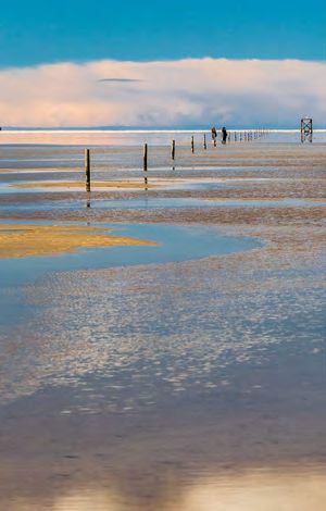
Seabed meets Horizon

2                                                                                                                                                       3

    Seabed meets Horizon
    The tidal flats between Den Helder in the Netherlands
    and Esbjerg in Denmark are the largest continuous tidal
    flats in the world and one of the last areas in Europe
    where nature can still develop to a great extent without
    human influence. So that this can continue, the German
    coastal states established three national parks: in 1985 the
    Schleswig-Holstein Wadden Sea, in 1986 Lower Saxony
    Wadden Sea and in 1990 the Hamburg Wadden Sea. The
    Wadden Sea was also placed on the UNESCO World
    Heritage List.                                                            The Halligen are unique to the Wadden Sea in Schleswig-Holstein. They
                                                                              have mostly low dykes and therefore f lood during storms. Then only the
    National Parks are symbols of untouched nature. Here                      artificial mounds („Warften“), on which the houses stand, remain above
    nature may develop freely, without human intervention.                    water.

    The idea came from the USA. There the first National
                                                                                Certified tidal flats
    Park in the world was established in 1872 - Yellowstone,
                                                                                Schleswig-Holstein Wadden Sea is more than just a National
    a mountain landscape with geysers and sulphur springs. In                   Park. It fulfils different international criteria for protected areas
    Germany there are 16 of these special protected areas.                      and was established as a
                                                                                • UNESCO World Natural Heritage Site
    ‘Let nature be nature’ is the objective of all National Parks.
                                                                                • United Nations Biosphere Reserve which also includes the
    All of nature should be maintained – not just the animals
                                                                                  Halligen.
    and plants, but the scenery in its totality, with mountains
                                                                                • EU Birds Directive and Flora and Fauna Habitats Directive site
    and lakes or, in our case, tidal flats and tidal creeks, dunes                (incl. the Halligen)
    and salt meadows. So that present and future generations                    • Wetland of International Importance under the Ramsar
    can be inspired by nature in the Wadden Sea region,                           Convention (incl. the Halligen)
    visitors are welcome. Research is also carried out there in                 • Particularly Sensitive Sea Area of the International Maritime
    order to ensure its better protection.                                        Organization.

                                                                              Between Land and Sea
                                                                              From the salt marshes to the tidal creeks, from the dunes
                                                                              to the sand banks - the tidal flats form the meeting point
                                                                              between land and sea. The tidal flats are flooded twice a
                                                                              day at high tide. The tidal range is three metres. The tidal
                                                                              creeks, which wind like rivers through sand and silt, form the
    Of the three Wadden Sea National Parks, Schleswig-Holstein has (with 30
    kilometres) the widest tidal f lat belt between mainland and open sea.    connection with the open sea.
4 5
Feathered Guests
Twice a day the seabed meets the horizon: low tide expo-
ses tidal flats full of worms, mussels and snails – a feast for
birds. In late summer and autumn four million birds use
the tidal flats, salt marshes and sands of the National Park
as a feeding place or to rest.
On the long journey between the breeding areas in Scan-
dinavia, north Siberia and north-east Canada and the
over-wintering sites in Western Europe and West Africa,
the food rich tidal flats are a vital stopover for about 40
species of migratory birds. 30 coastal bird species, with
100,000 pairs in total, breed in the Schleswig-Holstein Brent Geese breed in northern Siberia and boost their energy reserves for
National Park. During breeding season the most impor- the long f light ahead by feeding on plants from the salt marshes. Especially
the Halligen are important for Brent Geese where in spring up to 40,000
tant nesting sites on beaches, in salt marshes or dunes birds are present in total; many of them can be observed during the Brent
Goose Days at close range. (www.ringelganstage.de)
are closed to the public. National Park Rangers and the
employees of nature conservation organisations pro-
vide information and make sure that these sites are well
protected.
Breeding and resting bird numbers
in the Schleswig-Holstein Wadden Sea
Bird species Maximum Period with Amount of Breeding
number per year maximum Western numbers
(2014 - 2018) number European (pairs in 2017)
population (%)
Barnacle Goose 200.000 Autumn 20 600
Brent Goose 80.000 Spring 30 0
Common Shelduck 160.000 Summer 60 2.200
Eurasian Wigeon 200.000 Autumn 13 25
Common Eider 46.000 Autumn 6 500
Eurasian Oystercatcher 80.000 Autumn 9 9.500
Pied Avocet 4.000 Spring 10 2.500
For the Common Shelduck the southern part of the National Park is an Grey Plover 32.000 Spring 16 0
important moulting place. From July onwards 160,000 of these white, russet Red Knot 140.000 Spring 19 0
Dunlin 200.000 Spring 16 5
and black ducks, more than 50 percent of the European population arrive
Bar-tailed Godwit 70.000 Spring 11 0
there from France, England, Scandinavia and the Baltic states to moult. Eurasian Curlew 40.000 Autumn 6 5
They are f lightless for four weeks. On foot or swimming, they can find Common Redshank 14.000 Autumn 7 4.800
plenty of food in the undisturbed tidal creeks around Trischen to fulfil the Black-headed Gull 90.000 Autumn 3 32.000
Herring Gull 22.000 Autumn 2 7.200
high energy needs of replacing their feathers.6 7
Seals and Porpoises
In the Schleswig-Holstein Wadden Sea there are about
13,000 Common Seals and 200 Grey Seals. The male Grey,
at more than two metres body length, is half a metre bigger
than the Common Seal. Both seal species are Germany’s
biggest predators.
In the National Park there are some 1,000 Harbour Por-
poises, a 1.5 metre long relative of the dolphin. Many female
Harbour Porpoises with their young are regularly sighted
off the west coast of Sylt and Amrum. Therefore, a cetacean The Lugworm lives in a U-shaped burrow 25 centimetres deep in the
protection area was established there as a part of the Natio- ground. It eats sand, digests the bacteria and algae living in it and excretes
typical worm casts made of cleaned fine sand.
nal Park.
Common Seals, Grey Seals and Harbour Porpoises are the
top of the food chain in the Wadden Sea. Here one can Worms and Mollusces
observe them in large numbers, in contrast to the mainland
where these top predators like brown bear or wolf are absent. An enormous variety of invertebrate animals inhabit the
Wadden Sea. Especially the salt marshes have a diverse
invertebrate fauna. The tidal flats contain a higher animal
biomass than the rain forest. Beside crabs, mussels and
snails there is a microcosm of tiny creatures. They live in
the spaces between the sand grains.
At the beginning of the food chain are bacteria and single
cell algae. On the surface of the tidal flats they can be
clearly recognized as a red-brown layer, crossed by fine
stripes: these are the food tracks of the tiny (few millime-
tres long) Mudsnail, with up to 120,000 individuals per
square metre.
The branched tidal creeks, the water veins of the tidal
flats, are a nursery for a number of fish species: possibly
half of the plaices, herrings and soles which occurr in the
Common Seals live on fish which they catch on long hunts far out in the
North Sea. Afterwards they rest on the sand banks of the National Park. North Sea have grown up here. In addition there are many
The young (pups) are also born and nursed on the sandbanks, where they small crustaceans. These shrimps and small fish are food
shouldn‘t be disturbed. for gulls and terns and also for seals and porpoises.8 9
List DENMARK
The National Park
at a Glance Tondern
Westerland
The Schleswig-Holstein Wadden
Wal-
Sea is the largest national park to SYLT
human use Klanxbüll
be found between the North Cape schutz- exclusion
and Sicily. Its border lies 150 gebiet zone Niebüll
metres seawards of the dykes and
dunes. The inhabited islands and Dagebüll
FÖHR
Halligen are not included in the
Wyk Schlüttsiel
National Park area. OLAND
AMRUM
LANGENESS
GRÖDE
National Park area: HAMBURGER
Bredstedt
HALLIG
4,410 km² = 441,000 ha,
HOOGE
99,9% owned by the State of
NORDSTRANDISCH-
Schleswig-Holstein PELLWORM MOOR
Protection Zone 1: NORD-
STRAND Husum
1,579 km², of which 126 km²
is completly free of human
utilisation Westerhever Friedrichstadt
Protection Zone 2:
St. Peter-
2,801 km², of which 1,235 km² Ording Tönning
is a cetacean protection area
HELGOLAND
Legislation:
National Park Law 1985, Heide
amended 1999
Inhabitants: 10 km
Büsum
3 permanent residents (Hallig
National Park boundary
Süderoog), about 2,300 plant Protection zone 1 (light area)
TRISCHEN
species and 4,200 animal species Tidal flats
Salt marshes Friedrichskoog
High and low points: Sand, dunes
National Park information
+8 m (Warft on Süderoog),
to -27 m to the south of Amrum
ELBE10 11
Marshes by the Sea People in the National Park
Salt marshes lie only slightly Around 299,000 people live in the districts of Nordfries-
above sea level; some are flooded land and Dithmarschen which border the National Park,
more than 100 times a year. As a 25,000 of them on the islands of Sylt, Amrum, Föhr and
result about 40 highly specialised Pellworm, 270 on the Halligen. 78 shrimp boats and 7
plant species grow here which are mussel-dredgers operate in the National Park, 42 farmers
adapted to the water and saline are allowed to graze sheep on the salt marshes.
conditions. The purple flowered
Common Sea Lavender or the fra-
grant Sea Wormwood can grow
where they are not grazed by
25 insect species live on
sheep. The grass and herbs of the the Sea Aster.
salt marshes are a home to about
1,800 insect and spider species of which 250 are only
found there, for example Pseudaplemonus limonii, a weevil
living only on Sea Lavender.
The Multimar Wattforum in Tönning is the largest information centre in
the National Park. 180.000 visitors experience the aquariums, the 18 metre
long sperm whale skeleton and many interactive exhibits each year.
The most important economic factor for residents in the
National Park region is tourism. It contributes to 35 per-
cent of people‘s income on the Schleswig-Holstein North
Sea coast. 2 million overnight visitors are registered each
year in the National Park region and 13 million people
visit the area as day-trippers.
Nature conservation organisations, National Park tidal
flat guides and National Park rangers offer over 5,000
trips and tidal flat tours for about 140,000 participants.
Until the beginning of the 1990s, most of the 70 square kilometres of salt In addition, there are boat tours with wildlife watching,
marshes in the National Park were used intensively for sheep grazing. The birding excursions and similar activities. Numerous infor-
short-grazed marshes were very poor in species. Today there is a mosaic
of salt-marsh types from the completely ungrazed salt marshes on which mation boards, leaflets and web sites provide up-to-date
the Common Sea Lavender f lowers again to the lightly and heavily grazed information.
areas.12 13
National Park Regulations
Permitted (+) and forbidden(-)
The regulations effective in the National Park are deter-
mined by the National Park Law of 1985 (amended 1999). Activity Protection Protection Protection
The National Park is split into protected zones: Protection Zone 1 Zone 1 Zone 2
human use exclusion all other zone 1
Zone 1 is largely free of human use and nature can take its zone (to the north areas
of Föhr)
course, while Protection Zone 2 can allow for limited use.
To do justice to nature as well as to people, there are many Individuals
Travelling
exceptions and special provisions for visitors and National +1 +1 +1
by boat
Park users with local rights. Thus, shrimp fishing is permit- Access - -2 +
Flying kites - -2 +
ted in Protection Zone 1. An absolutely untouched human Let dogs run free - - -
use exclusion zone of 126 kms2 exists between the islands of Hunting - - -
Collecting
Sylt and Föhr. To the west of Sylt and Amrum is a cetacean archaeological remains - - -
protection area which is part of Protection Zone 2. Collecting mussels
3, 4
- -2 +
Collecting
Voluntary arrangements exist with fishermen, boat owners, seashells
- -2 +
water sport associations and local authorities. For example Picking plants - - +5
Horse riding - -6 -6
during the Shelduck moulting season, from July to Sep- Disturbing animals - - -
tember, shrimp fishing boat owners and sports boat owners Overnight camping - - -
Walking on tidal flats - -7 +
have agreed to avoid creeks and channels in the southern -
Digging worms 4 -2 +
tidal flats in the county of Dithmarschen in order to reduce
disturbance of the birds. Commercial
Oil production - - -8
Angling, swimming or taking photos are permitted in areas Collecting oysters 9 - - +
Fishing for
where access is not restricted. shrimps and fish - + +
Dredging for
cockles
- - -
Dredging for
mussels 9 - - +
1 in certain areas designated on nautical charts it is not allowed to depart
from the waterways during low tide
2
permitted in the area up to approx. 1 km from the coast line (observe local signs)
3
Oysters and mussels for own consumption, max. 10 l/day
4
Fishing permit necessary
5
Small bunch, with the exception of specially protected species like
Common Sea Lavender and Sea Thrift
6
only certain areas
7
only near to the coast (approx. 1 km) and on certain routes with tidal flat guides
8
only from the oil platform Mittelplate A
9
according to the mussel fishery program14 15
Who Does What?
The National Park Administration in Tönning acts as The National Park Aministration is an authority of the
a service provider bringing together the protection of Schleswig-Holstein Ministry of the Environment. Impor-
nature and the interests of visitors, local farmers, shrimp tant decisions concerning the National Park are discussed
fishermen, tidal flat guides, as well as yachtsmen, scientists by the National Park Committees of Nordfriesland and
and many others. It co-ordinates and approves research, Dithmarschen. The National Park Administration is
projects and necessary maintenance and construction strongly supported by nature conservation associations.
work. Together with the other Wadden Sea states, it orga- Some of them were operating for a long time before the
nizes extensive environmental monitoring programmes National Park was established to preserve Wadden Sea.
in which, for instance, seals and birds are counted and They warden National Park areas and run National Park
biological phenomena are documented. The general public information centres, support environmental monitoring
is kept informed by the rangers and information centres and lead numerous excursions within the National Park.
such as the National Park information centre Multimar
Wattforum, as well as through the media. Attractive envi-
ronmental education programmes are offered to schools
and teachers.
National Park Partners
Tourism companies and authorities which
are especially connected to the National
Park can become National Park partners. They meet special
high-quality criteria and inform guests and customers about the
National Park and the region. Tidal flat guides, tour operators, rail
companies, accommodation companies, shipping companies and
others offer excursions, tours or lodgings with first class National
Park experiences.
www.nationalpark-partner-sh.de
Halligen Biosphere
Since 2004 the five inhabited Halligen Langeneß, Oland, Hooge,
Nordstrandischmoor and Gröde have belonged to the develop-
ment zone of the ‘Biosphere Reserve Schleswig-Holstein Wadden
Sea and Halligen’. Thereby they have become a part of a world-
wide network of UNESCO model regions in which nature and
The young people who perform voluntary ecological work in the nature
humans live together. The objectives include the protection of
conservation associations have something in common with the rangers: their
nature, sustainable management, socially fair development, as
enthusiasm for the National Park. Get inspired too!
well as education, research and environmental monitoring.
www.halligen.deInformation ...about North Sea tourism: North Sea Hotline +49 4841 89750 www.nordseetourismus.de www.nordsee-naturerlebnis.de ...about the National Park and it´s activities: National Park Telephone +49 4861 96200 www.nationalpark-wattenmeer.de www.multimar-wattforum.de www.nationalpark-partner-sh.de www.waddensea-worldheritage.org LKN.SH/National Park Admistration Schlossgarten 1, D-25832 Tönning www.nationalpark-wattenmeer.de www.lkn.schleswig-holstein.de Text: Sina Clorius, translation: Mark Sixsmith Photos: LKN.SH/Brunckhorst (page 5, 15 left), LKN.SH/Schröder (page 11), LKN.SH/Stock (all others) Layout: Elisabeth Koop 12 | 2021
You can also read